WKN Weer, Klimaat en Natuurrampen
Lees alles over het onstuimige weer op onze planeet, volg orkanen en tornado's, zie hoe vulkanen uitbarsten en hoe Moeder Aarde beeft bij een aardbeving. Alles over de verwoestende kracht van onze planeet en tal van andere natuurverschijnselen.


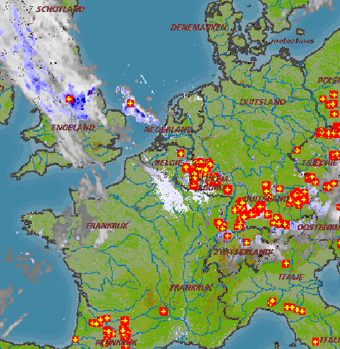
Wordt idd een beetje rood daar op de radarquote:Op vrijdag 3 juli 2009 11:19 schreef Klonk het volgende:
bwoahhh, kijk het eens ontploffen boven de Ardennen en Eifel

Op donderdag 28 juni 2012 20:52 schreef Peterselieman het volgende:
We hebben Sjorsduels. Saaie wedstrijden waarin niets gebeurt en die ellendig lang duren :P
We hebben Sjorsduels. Saaie wedstrijden waarin niets gebeurt en die ellendig lang duren :P
het is net alsof iemand daar een ballon met onweer op aan het blazen is, echt heel indrukwekkend om te zien hoe het vanuit een klein pitje in eens boeeemmmm doet
Klonk is alleen Klonk als er Klonk op staat
Dit weer doet met trouwens denken aan het onweer in juni of juli van 2000.
Dat begon ook met een gruwelijk klamme dag (bij 30°C), toen 's middags de lucht een gele kleur kreeg, constant gerommel hoorbaar was en de regen en de grote hagelstenen met bakken uit de lucht kwam.
Trouwens op Estofex staat een veelbelovende voorspelling:
Ten zuiden van Eindhoven (boven België) is ook al onweer geregistreerd.
Dat begon ook met een gruwelijk klamme dag (bij 30°C), toen 's middags de lucht een gele kleur kreeg, constant gerommel hoorbaar was en de regen en de grote hagelstenen met bakken uit de lucht kwam.
Trouwens op Estofex staat een veelbelovende voorspelling:
Als het begint, dan gaan we er schijnbaar lang van genieten.quote:Words like 'forcing', 'front' and 'dynamic' can finally be involved again in the forecast. A constantly weakening cold front from W-France draws near during the afternoon hours and probably dissolves somewhere over the highlighted area. Shear at all levels remains weak although a marginal increase in speed shear is possible at mid-levels. The main advantage with such a feature is that moisture pooling along the convergence zone will assist in a concentrated swath of 800-1500J/kg MLCAPE as mid-level lapse rates steepen somewhat. Excessive rain due to slow storm movement will be the main hazard, but an isolated large hail report can't be ruled out, given better instability release and a slim increase in wind speeds throughout the troposphere. However the main effect of this set-up will be the longevity of thunderstorms mainly over Belgium, the Netherlands, Luxembourg and W-Germany, which will continue well into the night, probably until next morning. Isolated tornadoes are possible during the peak time heating with GFS showing LL CAPE of roughly 200J/kg.
Ten zuiden van Eindhoven (boven België) is ook al onweer geregistreerd.


28,7°C om 11:30u (Eindhoven & Twenthe)
Arcen (28,8°C om 11:20u) zit waarschijnlijk nog iets hoger, maar de site van het KNMI is nog niet zo ver met updaten.
Arcen (28,8°C om 11:20u) zit waarschijnlijk nog iets hoger, maar de site van het KNMI is nog niet zo ver met updaten.
Het schiet echt als een raket omhoogquote:
Op donderdag 28 juni 2012 20:52 schreef Peterselieman het volgende:
We hebben Sjorsduels. Saaie wedstrijden waarin niets gebeurt en die ellendig lang duren :P
We hebben Sjorsduels. Saaie wedstrijden waarin niets gebeurt en die ellendig lang duren :P

Hoe roze gaat Nederland worden!quote:
Vedanta_veri: Ik vraag mij af waarom iedereen zo voor het verbod op pedofilie is maar niet op roken, beiden zijn dingen waar je anderen mee beschadigd. Maar goed, mensen die verslaafd zijn aan iets kunnen daar niet objectief over zijn.
Volkel ook (29,1)quote:
Arcen 29,4°C (11:30u)
Ook de Achterhoek doet mee met 29,2°C
Op donderdag 28 juni 2012 20:52 schreef Peterselieman het volgende:
We hebben Sjorsduels. Saaie wedstrijden waarin niets gebeurt en die ellendig lang duren :P
We hebben Sjorsduels. Saaie wedstrijden waarin niets gebeurt en die ellendig lang duren :P

In Eindhoven weer 28,6°C
De eerste tekenen van convectie zijn inmiddels te zien vanaf hier. Naar het zuiden toe zijn door de vochtige lucht de contouren van een stapelwolk herkenbaar.
De eerste tekenen van convectie zijn inmiddels te zien vanaf hier. Naar het zuiden toe zijn door de vochtige lucht de contouren van een stapelwolk herkenbaar.
Heb op YouTube nog twee filmpjes gevonden, over die onweersbui die vorig jaar over mijn dorp trok. Dat was echt mooi spul. 


Als het goed is moet er over Noordwijk zometeen een buitje trekken Kan wel wat verkoeling gebruiken.
Voordat dat hier in de achterhoek is zit je denk aan het eind van de middag en dan zal het hier wel 31/32 graden zijn. Ik ga nog mooi even deels van de zon genieten en deels wat in de tuin doen voordat strax de grond weer veel te nat is
Never Stop Exploring!
Life begins at the end of your comfort zone!
Follow me on Twitter: https://twitter.com/EdwinKr83 Instagram: https://www.instagram.com/edwinkr83/
Life begins at the end of your comfort zone!
Follow me on Twitter: https://twitter.com/EdwinKr83 Instagram: https://www.instagram.com/edwinkr83/

ik zie niet veel gebeuren eigenlijk...quote:Op vrijdag 3 juli 2009 12:05 schreef Zipportal het volgende:
Boven Flevoland ontstaat ook iets kleins. Richting het noorden a.u.b.
[ afbeelding ]
* I intend to live forever, so far so good! *