WKN Weer, Klimaat en Natuurrampen
Lees alles over het onstuimige weer op onze planeet, volg orkanen en tornado's, zie hoe vulkanen uitbarsten en hoe Moeder Aarde beeft bij een aardbeving. Alles over de verwoestende kracht van onze planeet en tal van andere natuurverschijnselen.


Flink sterker geworden dan verwacht, gister was de verwachting dat het pas een orkaan zou worden als het de eilandengroep was gepasseerd 
Storm naar Bovenwindse eilanden
WILLEMSTAD - Voor de eilanden Sint Maarten, Sint Eustatius en Saba is dinsdagavond (lokale tijd) door de Antilliaanse regering een 'hurricane watch' en een 'tropical storm warning' uitgegeven.
Dit is gebeurd mede op basis van voorspellingen van het National Hurricane Center in Miami. Dinsdag waaide Omar nog als tropische storm over de Antilliaanse eilanden Aruba, Bonaire en Curaçao. De verwachting is dat de storm uitgroeit tot een orkaan in de categorie twee en woensdag aan het einde van de dag de eilanden Sint Maarten, Sint Eustatius en Saba treft.
De scholen op die eilanden zijn woensdag zeker dicht. Ook zijn verschillende andere voorzorgsmaatregelen genomen, zoals het verlagen van het waterpeil van de Great Salt Pond en de Fresh Pond in Sint Maarten.De bevolking wordt aangeraden de laatste nieuwsberichten op de radio goed te volgen.
Op Curaçao is inmiddels duidelijk dat door Omar bijna alle stranden flinke schade hebben opgelopen, zo heeft gezaghebber Dindial bekend gemaakt.
quote:Category 3 Hurricane Omar Slams Northern Carribean
CHRISTIANSTED, U.S. Virgin Islands — Hurricane Omar was quickly moving away from the northern Leeward Islands early Thursday after passing through the area as a major Category 3 storm that caused little damage.
The powerful core of the storm, with the most intense winds, passed overnight between St. Martin and the U.S. Virgin Islands, said Lixion Avila, a hurricane specialist with the U.S. National Hurricane Center.
"It could have been worse," Avila said. "They were very, very lucky."
Hurricane Omar had maximum sustained winds of 125 mph but a last-minute shift to the east meant that St. Croix, the most populated of the U.S. Virgin Islands, experienced the weaker side of the system. Winds there reached just 48 mph mph, officials said.
The storm knocked down trees, caused some flooding and minor mudslides but there were no immediate reports of deaths or major damage, said Mark Walters, director of the U.S. Virgin Islands disaster management agency.
The nearby British Virgin Islands also emerged largely unscathed, said Deputy Gov. Inez Archibald, noting there was little damage beyond some mudslides and scattered debris.
"We did reasonably well actually," Inez told The Associated Press. "We did not get what we expected."
Early Thursday morning, Omar was centered about 160 miles northeast of the Northern Leeward Islands. It was moving northeast near 30 mph and had maximum sustained winds of 115 mph.
Omar was taking an unusual southwest-to-the-northeast track toward the central North Atlantic, well away from the U.S. mainland.
On the Puerto Rican island of Vieques, which was brushed by the storm, people returned to their homes from shelters where they spent the night and awaited the resumption of ferry service to the mainland of the U.S. island territory. Lingering bands of the storm were expected to bring rain and rough seas.
"Everything was calm, nothing happened," said Joselyn Ponce of the local office of emergency services.
One death was reported on Puerto Rico's tiny island of Culebra. Authorities say a 55-year-old man collapsed from cardiac arrest while trying to install storm shutters on his house.
Many people throughout the islands had feared the worst and spent Wednesday securing their homes and making sure they had enough food, water and batteries.
"I plan to stay up all night and ride out the storm, but I have a feeling it's going to be very bad," said St. Croix resident Helino Cruz, retiree from the island's giant Hovensa oil refinery.
The refinery, one of the 10 largest in the world, shut down operations for the storm. Hovensa was expected to conduct an inspection for any damage before deciding whether to restart the refinery.
Hurricane Omar forced at least three cruise ships to divert course. Flights were canceled on several islands.


Madagascar krijgt vaak bezoek.quote:Op maandag 20 oktober 2008 15:59 schreef Frutsel het volgende:
[ afbeelding ]
Kuchkuch
Madagascar krijgt Asma op bezoek
Klopt, Somalië en Yemen af en toequote:Op maandag 20 oktober 2008 20:26 schreef aloa het volgende:
[..]
Madagascar krijgt vaak bezoek.
[ afbeelding ]
Regendrama in Jemen
SAYOUN - Overstromingen in Zuid-Jemen hebben tot gisteravond aan zeker 61 mensen het leven gekost.
De Jemenitische autoriteiten hebben dat bekendgemaakt.
De politie in de afgelegen provincie Hadramaut waarschuwde dat het dodencijfer verder kan oplopen omdat nog tientallen mensen worden vermist.
Vooral de zuidoostelijke provincies Hadramaut en Mahara zijn zwaar getroffen door het noodweer in de regio. Honderden woningen zijn vernietigd. Gezinnen die niet dakloos zijn geraakt, kampen wel met ernstige wateroverlast. Inmiddels wordt geprobeerd met helikopters tenten, medicijnen en andere noodgoederen naar het gebied te brengen, dat door de modderstromen over de weg niet meer te bereiken is.
Jemen werd gisteren opnieuw door veel regen getroffen, hoewel de regenval in Hadramaut niet zo zwaar was als eerder. De storm, die de regens met zich meebracht, begon al weken geleden.
De historische hoogbouw in woestijnstad Shibam, die op de werelderfgoedlijst van Unesco staat, wordt bedreigd. De stad, met zo'n 20.000 inwoners, is volledig geïsoleerd en kampt met elektricteit- en drinkwaterproblemen. Inmiddels heeft Jemen een internationaal hulpverzoek laten uitgaan.
Minister Bert Koenders van Ontwikkelingssamenwerking vertrekt vandaag voor een driedaags werkbezoek naar Jemen. Hij zal zich daar onder meer op de hoogte laten stellen van de gevolgen van de overstromingen.
Het bezoek van Koenders staat in het teken van dertig jaar betrekkingen tussen Nederland en het streng islamitische land, dat jaarlijks ongeveer 30 miljoen euro ontwikkelingsgeld van Nederland ontvangt.
Jemen is een van de armste en minst ontwikkelde landen van de wereld. Het scoort slecht op internationale ranglijsten over de staat van het onderwijs, de gezondheidszorg, veilige watervoorzieningen, de positie van vrouwen, mensenrechten en persvrijheid.
De regering in de hoofdstad Sanaa heeft bovendien te kampen met rebellie en geweld in het voormalige onafhankelijke noorden, tribale onrust in het zuidoosten en een toestroom van Somalische vluchtelingen langs de kust


Tropical Depression Three, Gulf of Aden
The third tropical cyclone of the season in the northern Indian Ocean brought rare rains to the desert regions of Yemen and Oman in the third week of October 2008 after the storm hooked around the Horn of Africa and entered the Gulf of Aden. This image of the storm was captured on October 23, 2008, by the Moderate Resolution Imaging Spectroradiometer (MODIS) on NASA’s Terra satellite.
Tropical Storm Three formed in the Indian Ocean southeast of the island of Socotra and headed northwest over the island. It skirted the Horn of Africa and headed west. The storm only briefly reached “Tropical Storm” status before it weakened to a tropical depression. By the time of this image, the storm did not have the iconic pinwheel shape and distinct eye of a powerful storm, but hints of its cyclonic nature were visible. Airflow spiraled inward in a counterclockwise direction toward a storm center located near the eastern shoreline of Yemen. Two patches of intensely bright clouds around this center of rotation signal areas of severe thunderstorms.
According to a blog posting by international meteorologist Jim Andrews with Accuweather.com, the storm was bringing scattered downpours over areas that are accustomed to going a year or more without significant rainfall. Local flash flooding was likely along the coast of Yemen, Oman, and northeastern Somalia.
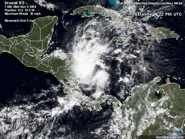
Misschien dat dit nog gaat uitgroeien tot iets groots.
Het systeem ligt nu voor de kust van Nicaragua.
navy
Het systeem ligt nu voor de kust van Nicaragua.
navy


Dit is denk ik ook de laatste van 2008quote:Op donderdag 6 november 2008 18:18 schreef Co_OL het volgende:
Het water is al een stuk kouder zag ik dus CAT 4 orkies zullen er niet meer onstaan denk ik
Paloma gaar waarschijnlijk nog een categorie 3 worden.
quote:Strengthening Hurricane Paloma threatens Caymans 07 Nov 2008 18:29:40 GMT
GEORGE TOWN, Nov 7 (Reuters) - Residents of the Cayman Islands braced for Hurricane Paloma on Friday as it strengthened rapidly while bearing down on the wealthy British territory on a path that could also threaten Cuba.
"No one thought this storm would come in so quickly," said Levonne Johnston," a resident of George Town, the Cayman Islands capital, which was expected to take a lashing from the eighth hurricane of the 2008 Atlantic storm season.
"We are just doing whatever we can with the couple of hours we have left and then knuckle down and wait out the storm," Johnston said.
Paloma doused Honduras with heavy rains on Thursday, adding to misery in the impoverished Central American country where the U.N. estimates 70,000 people have been made homeless by recent storms.
It posed no threat to U.S. oil installations in the Gulf of Mexico on its passage northward but U.S. forecasters said it was strengthening on Friday and could become a "major" hurricane with maximum sustained winds of at least 111 miles per hour (178 kph) by Saturday.
At 1 p.m. EST (1800 GMT), Paloma was 60 miles (100 km) south of Grand Cayman and moving north-northeast at 6 mph (10 km), the U.S. National Hurricane Center said.
Its top sustained winds increased to 90 mph (150 kph), making Paloma a strong Category 1 hurricane on the five-step Saffir-Simpson intensity scale, the Miami-based center said.
Rainfall totaling up to 12 inches (30 cm) was expected over parts of the Cayman Islands and its national weather service forecast waves rising up to 30 feet (9 metres) off the islands, triggering potentially dangerous coastal storm surges.
CATEGORY 3 POTENTIAL
The hurricane center said the storm was likely to become a Category 2 hurricane later on Friday, before possibly growing into a fearsome Category 3. Hurricane Katrina was a Category 3 storm when it came ashore near New Orleans in 2005 and swamped the vulnerable, low-lying city.
"The center of Paloma will pass near the Cayman Islands late today or early Saturday and be approaching the coast of central Cuba late Saturday," the hurricane center said.
Government offices were closed and the storm forced the postponement of a national festival known as Pirates Week, a major tourist draw. Many tourists already had cut short their vacations in order to evacuate.
"We're going to Cancun where it's sunny," said Steve Keith, a visitor who was married in Grand Cayman on Thursday night and had intended to spend his honeymoon there.
Paloma came in the last month of what experts correctly predicted would be a busier than normal storm season.
It was expected to hit Cuba after its brush with the Cayman Islands, though possibly as a weakening hurricane.
The communist-ruled island still is dealing with devastating effects from two powerful hurricanes that caused more than $5 billion in damage two months ago.
The Atlantic hurricane season runs from June 1 to Nov. 30. (Writing by Tom Brown and Jane Sutton; Editing by Michael Christie and Bill Trott)


quote:Hurricane Paloma strengthens, heads for Cuba 08 Nov 2008 15:40:40 GMT
Source: Reuters
(Updates with details, quotes, new storm position)
By Shurna Robbins
GEORGE TOWN, Nov 8 (Reuters) - Hurricane Paloma strengthened into an "extremely dangerous" Category 4 storm on Saturday as it pounded the wealthy British Caribbean territory of the Cayman Islands and headed toward storm-battered Cuba.
Paloma's eye passed just to the east of Grand Cayman, the main island and home to most of the more than 50,000 people in the important offshore financial center, but damage appeared to be light and there were no immediate reports of deaths.
"There is no damage to central George Town, where the bulk of the financial sector is located," said Cindy Scotland, an official with the Cayman Islands Monetary Authority. "So there is no reason to think there has been any damage in any way to the infrastructure of the financial services sector."
"The Authority does not expect any reports of significant, if any, interruptions in business," she said.
Cuba, already hammered this year by hurricanes Gustav and Ike, declared an emergency in central and eastern parts of the island, canceled all national air and ground transportation and began evacuating hundreds of thousands of residents.
Authorities issued an "all-clear" early Saturday for Grand Cayman but cautioned residents to move about carefully. Power was out in some parts of the island and the streets of George Town were littered with tree branches.
Paloma's sustained winds increased to 140 miles per hour (225 km per hour) early on Saturday as the storm hurtled across the group's smaller islands, Cayman Brac, home to 1,800 people, and Little Cayman, with a population of about 100.
Gov. Stuart Jack asked that the British auxiliary ship Wave Ruler head straight to the smaller islands after the storm passes.
"Paloma is now an extremely dangerous category four hurricane on the Saffir-Simpson scale," the U.S. National Hurricane Center said.
Category 4 hurricanes can generate tidal surges up to 18 feet (5.5 metres) above normal and their winds can tear off the roofs and blow out the doors and windows of small homes.
Hurricane Ivan had 160 mph (260 kph) winds when it slammed the Caymans in 2004, causing extensive damage. But the islands and their solid structures are considered less vulnerable than other Caribbean islands to the fierce tropical storms that churn through between June and the end of November each year.
Paloma doused Honduras with heavy rains as it formed on Thursday, adding to misery in the impoverished Central American country where the United Nations estimates 70,000 people have been made homeless by recent storms.
It posed no threat to U.S. oil installations in the Gulf of Mexico.
In Cuba, Paloma was forecast to beat a northeast path through central Camaguey and eastern Las Tunas provinces. It was expected to weaken before hitting Cuba as a Category 3 storm, the forecasters said.
"I don't want to talk or hear about hurricanes, because they have already driven me crazy. First one came through from the north, now one is heading here from the south," Camaguey resident Carlos Martinez said. "I hope another doesn't fall from the sky."
Ailing former President Fidel Castro put damage from previous storms Ike and Gustav at $8 billion and blamed global warming for the number and power of the storms this year.
In a written statement published on Saturday, Castro rejected any aid from the United States before it was even offered, demanding instead that Washington lift economic sanctions tightened by U.S. President George W. Bush.
"Dignified conduct will again be needed if the head of the empire, who has been the chief instigator behind the genocidal blockade against our country, were to again offer pitiful aid. It will most surely be rejected," said Castro, who has not appeared in public since intestinal surgery in July 2006.
By 10 a.m. EST (1500 GMT), Paloma was about 130 miles (210 km) east-northeast of Grand Cayman Island and about 140 miles (225 km) southwest of Camaguey, Cuba, and moving east-northeast near 9 mph (14 kph), the hurricane center said. (Additional reporting by Marc Frank in Havana; writing by Jim Loney, editing by Vicki Allen)


ging wel erg snel naar CAT4.
Dostojewski: "Je kunt je niet van je eigen gezond verstand overtuigen door je buurman op te sluiten."
wel raar dat het ineens ophoud met de orkaan!
je zou toch zeggen dat op zee weer aan kracht toe neemt?
je zou toch zeggen dat op zee weer aan kracht toe neemt?
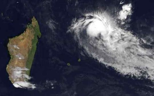
TS Anika
TS Three
Het orkaanseizoen in de Zuid Indische/West Australische oceaan lijkt ook van start te gaan
TS Three
Het orkaanseizoen in de Zuid Indische/West Australische oceaan lijkt ook van start te gaan
Yup....quote:Op donderdag 20 november 2008 09:49 schreef Frutsel het volgende:
Het orkaanseizoen in de Zuid Indische/West Australische oceaan lijkt ook van start te gaan
Cyclone 06B over Sri Lanka and India
On November 26, 2008, Cyclone 06B was passing northwest over the island of Sri Lanka and approaching the southern tip of India. This image of the storm was captured by the Moderate Resolution Imaging Spectroradiometer (MODIS) on NASA’s Terra satellite. The storm’s organization was being affected by passage over land. The clouds had a spiral pattern, but they were becoming ragged. According to reports from the Joint Typhoon Warning Center at 5:30 p.m. local time in Sri Lanka, the storm had sustained winds of 50 knots (58 mph), with gusts of up to 65 knots (75 mph).

On November 26, 2008, Cyclone 06B was passing northwest over the island of Sri Lanka and approaching the southern tip of India. This image of the storm was captured by the Moderate Resolution Imaging Spectroradiometer (MODIS) on NASA’s Terra satellite. The storm’s organization was being affected by passage over land. The clouds had a spiral pattern, but they were becoming ragged. According to reports from the Joint Typhoon Warning Center at 5:30 p.m. local time in Sri Lanka, the storm had sustained winds of 50 knots (58 mph), with gusts of up to 65 knots (75 mph).