WKN Weer, Klimaat en Natuurrampen
Lees alles over het onstuimige weer op onze planeet, volg orkanen en tornado's, zie hoe vulkanen uitbarsten en hoe Moeder Aarde beeft bij een aardbeving. Alles over de verwoestende kracht van onze planeet en tal van andere natuurverschijnselen.


wel interessant om eens te kijken waar dan de verschillen zitten tussen die modellen. voor de mensen die eraan werken dan, ik begrijp daar geen barst van natuurlijkquote:Op vrijdag 29 augustus 2008 13:01 schreef Basp1 het volgende:
[..]
Ja dat is idd wel vreemd om te zien 3 die direct op new orleans afgaan en 3 die naar texas gaan.
[b]Op maandag 6 september 2010 00:28 schreef tong80 het volgende:[/b]
GVD Wat moet jij een trotse vader zijn :)
:P
GVD Wat moet jij een trotse vader zijn :)
:P
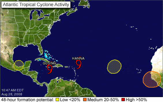
En dan te bedenk dat Hanna van de andere kant komt 
en er nog 3 plekken voor potentiele ontwikkeling zijn
en er nog 3 plekken voor potentiele ontwikkeling zijn
Gustav lijkt meer op verhoging van de olieprijs af te stevenen (boorplatforms, raffinage).quote:Op vrijdag 29 augustus 2008 13:01 schreef Basp1 het volgende:
[..]
Ja dat is idd wel vreemd om te zien 3 die direct op new orleans afgaan en 3 die naar texas gaan.
Voor de Amerikaanse economie gaat Gustav beter niet linksaf.quote:Shell evacueert al zijn personeel uit de Golf van Mexico vanwege de tropische storm Gustav.Er zijn al 750 mensen aan land gebracht en de rest volgt vandaag en morgen.De actie zal gevolgen hebben voor de olieproductie.

quote:Op vrijdag 29 augustus 2008 15:16 schreef okee6 het volgende:
Voor de Amerikaanse economie gaat Gustav beter niet linksaf.

Steeds meer lijntjes in dezelfde richting.. geen garanties, maar echt goed ziet het er ook niet uit.
ik heb een vraag voor jullie weerkundigenquote:
waarom kiezen die amerikanen voor zo'n oorkaan geteisterde gebeid
om al hun olie-platforms op te richten?
lijkt me geen gezond verstand, waarom kunnen ze dat niet gewoon elders bouwen en opereren?
of zijn dit net de amerikaanse bruggenbouwers die de hele bevolking van michigan in de steek hebben gelaten met die befaamde brug - (naam waarvan ik niet meer op kan komen)
AJ


en daar op het land, bij Houston vooral, bevindt zich ook het grootste chemisch industriegebied ter wereld (als je het Rotterdamse en Antwerpse chemisch industriegebied niet bij elkaar neemt)quote:
hm, de modellen zijn het opeens weer aardig met elkaar eens....quote:
[b]Op maandag 6 september 2010 00:28 schreef tong80 het volgende:[/b]
GVD Wat moet jij een trotse vader zijn :)
:P
GVD Wat moet jij een trotse vader zijn :)
:P

Ah, dat laatste is geruststellendquote:Gustav's top winds increased to 100 mph (155 km/hr) Saturday, making it a Category 2 storm as it approaches the western tip of Cuba, according to the National Hurricane Center in Miami, Florida.
Forecasters warn Gustav could grow to be a Category 4 hurricane on the Saffir-Simpson Scale as it barrels toward the U.S. Gulf Coast for a landfall late Monday or Tuesday, although they predict it would weaken to a Category 3 storm before reaching land.
Waarom heeft de olie zoveel miljoenen jaren geleden gekozen om zich in dat gebeid af te zetten.quote:Op zaterdag 30 augustus 2008 05:38 schreef zkr623 het volgende:
[..]
ik heb een vraag voor jullie weerkundigen
waarom kiezen die amerikanen voor zo'n oorkaan geteisterde gebeid
om al hun olie-platforms op te richten?
Of te wel olie zit niet overal, nog beter gezegd, olie zit bijna nergens en men is blij als men wat vindt.

Ik denk dat ze de olie met windenergie oppompen en dan met zeilbootjes naar de wal brengen. Dan is wind lekker makkelijk vooral ook omdat je altijd de orkaan in de rug hebt en dus lekker snel en goedkoop olie naar de wal kan krijgen.quote:Op zaterdag 30 augustus 2008 05:38 schreef zkr623 het volgende:
waarom kiezen die amerikanen voor zo'n oorkaan geteisterde gebeid
om al hun olie-platforms op te richten?
lijkt me geen gezond verstand, waarom kunnen ze dat niet gewoon elders bouwen en opereren?
quote:GEORGE TOWN, Cayman Islands — Gustav swelled to a Category 2 hurricane early Saturday with winds near 100 mph after plowing through the Cayman Islands toward Cuba, gathering strength on a journey that could take it to the U.S. Gulf Coast as a fearsome Category 3 storm three years after Hurricane Katrina.
Gustav, which killed 71 people in the Caribbean, hit the Caymans Friday with fierce winds that tore down trees and power lines. It was expected to cross Cuba's cigar country Saturday and head into the Gulf of Mexico by Sunday
Gustav first struck Cayman Brac and Little Cayman, the smaller easternmost "Sister Islands" in the chain. Storm surge and heavy rains flooded the streets.
More than 1,100 people were in government shelters in the three islands as high waves and heavy winds battered the chain, the National Emergency Operations Center said in a statement. No injuries were reported.
"We're just trying to wait it out," said Juliana O'Connor-Connolly, who represents the islands in the Cayman legislature, by cell phone from the kitchen of her farm on Cayman Brac.

En toen opeens zondag zegt Gustav ik ga haaks rechts af (cat4 dan) zo over miami heen!
Dat zou wat zijn en een grote ramp dan :|
Dat zou wat zijn en een grote ramp dan :|
dat is het enige geruststellende danquote:Op zaterdag 30 augustus 2008 10:58 schreef ItaloDancer het volgende:
[..]
Ah, dat laatste is geruststellend
Dat niet alleen, het laat ook zien dat de orkaan blijft hangen en niet overtrekt. Dat wordt veel regen... erg veel regen.quote:Op zaterdag 30 augustus 2008 09:03 schreef Againzender het volgende:
[..]
hm, de modellen zijn het opeens weer aardig met elkaar eens....
Misschien gaat de Superdome er dan nu wel eens definitief aan, dat miste nog de vorige keerquote:Op zaterdag 30 augustus 2008 11:40 schreef Drugshond het volgende:
[..]
Dat niet alleen, het laat ook zien dat de orkaan blijft hangen en niet overtrekt. Dat wordt veel regen... erg veel regen.
Die huizenprijzen zullen het daar goed doen.
Je kunt maar beter een camper hebben.... die kun je nog verplaatsen.
Je kunt maar beter een camper hebben.... die kun je nog verplaatsen.
zolang je met camper maar geen trailer bedoeldquote:Op zaterdag 30 augustus 2008 12:43 schreef Drugshond het volgende:
Die huizenprijzen zullen het daar goed doen.
Je kunt maar beter een camper hebben.... die kun je nog verplaatsen.


30 Augustus 2008
Orkaan Gustav neemt in kracht toe
Vanwege de naderende orkaan Gustav heeft de Amerikaanse president Bush de noodtoestand afgekondigd in Louisiana en Texas. Daardoor kan de hulpverlening vanuit Washington worden geregeld.
Bush wil voorkomen dat de hulpverlening weer misloopt, zoals drie jaar geleden toen Katrina het gebied rond New Orleans trof. Langs de Golfkust vielen toen 1800 doden.
Gustav is de afgelopen uren snel in kracht toegenomen en het Hurricane Centre heeft hem nu ingeschaald als een orkaan met kracht 3 met windsnelheden tot meer dan 180 kilometer per uur. De orkaan komt dinsdag in de VS aan land.
Uit de oude doos.
Pause ff op 0:49
Valt op dat al die Katrina topics op youtube opeens tot leven zijn gekomen. Dat is een soort chat commune geworden.

Pause ff op 0:49
Valt op dat al die Katrina topics op youtube opeens tot leven zijn gekomen. Dat is een soort chat commune geworden.
Gezamenlijke herinnering/trauma he..quote:Op zaterdag 30 augustus 2008 14:09 schreef Drugshond het volgende:
Uit de oude doos.
Pause ff op 0:49
Valt op dat al die Katrina topics op youtube opeens tot leven zijn gekomen. Dat is een soort chat commune geworden.


quote:HAVANA, Aug 30 (Reuters) - Powerful Hurricane Gustav roared toward western Cuba on Saturday with 125 mph (205 kph) winds on its way to the oil-rich Gulf of Mexico after a deadly pass through the Caribbean.
Gustav ripped across the Cayman Islands and closed in on Cuba's Isle of Youth before it was set to strike the Cuban mainland later in the day as a major hurricane.
Forecasters predicted Gustav would cross the Gulf of Mexico and hit central Louisiana on Tuesday with the same force that Hurricane Katrina delivered three years ago.
The U.S. National Hurricane Center said Gustav, gathering strength as it crossed the warm Caribbean, was a Category 3 storm on the five-stage Saffir-Simpson scale of hurricane intensity.
Any storm with winds of at least 111 mph (178 kph) is ranked "major" by the Miami-based hurricane center.
Gustav could grow to a Category 4, with winds of at least 131 mph (210 kph), before reaching the Cuban coast, and may strengthen further on Sunday when it goes into the Gulf of Mexico.
Zeer ongebruikelijk, in 12 uur tijd van cat 1 naar 4...
Interessante Twittersites over Gustav
http://www.twitter.com/MarkMayhew
http://www.twitter.com/hurricanes
http://www.twitter.com/dfwgustav
http://www.twitter.com/peakoil (die is van mij)
[ Bericht 43% gewijzigd door HansAEX op 30-08-2008 19:43:26 ]
Interessante Twittersites over Gustav
http://www.twitter.com/MarkMayhew
http://www.twitter.com/hurricanes
http://www.twitter.com/dfwgustav
http://www.twitter.com/peakoil (die is van mij)
[ Bericht 43% gewijzigd door HansAEX op 30-08-2008 19:43:26 ]

Kenner firefighters help administrators evacuate nursing, assisted living homes
Mandatory evacuations in St. Bernard, Plaquemines, St. Charles and lower Jefferson parishes
Public evacuation system might rely on school buses
Gustav strengthens to 'extremely dangerous Category 4 hurricane'
Greyhound, Amtrak routes canceled as city takes over transit station
Get out and take neighbors with you, St. Charles president urges
http://www.nola.com/
Dostojewski: "Je kunt je niet van je eigen gezond verstand overtuigen door je buurman op te sluiten."
Komt die over Key West(Florida? Vond op GLP een webcam
http://www.oceankey.com/interior.aspx?ID=1460
edit - Key West alleen Tropical Storm
http://www.srh.weather.gov/key/
http://www.oceankey.com/interior.aspx?ID=1460
edit - Key West alleen Tropical Storm
http://www.srh.weather.gov/key/
Dat is sneller dan de verwachting.quote:Op zaterdag 30 augustus 2008 19:37 schreef HansAEX het volgende:
Zeer ongebruikelijk, in 12 uur tijd van cat 1 naar 4...

Gisteren en vandaag stond er voor CAT 5 1 % en 6 % vanmiddag... nu opeens 34 % voor morgen
Maar goed het gaat erom waar deze staat op 08 PM Maandag (want dan komt hij ongeveer aan land). En ook dat is sneller dan de verwachting.... de voorgaande voorspellingen waren pas om 08 AM Dinsdag.
Hij heeft er duidelijk zin in.... snelheid en kracht nemen snel toe. En gaat via een rechte geodetische lijn op rampkoers op de Amerikaanse kust af.
MSNBC meldt cat 5
Maar dat wordt nog nergens bevestigd, laatste update NHC is cat 4
- edit: ook Wunderground en Weather Channel houden het op 4
Maar dat wordt nog nergens bevestigd, laatste update NHC is cat 4
- edit: ook Wunderground en Weather Channel houden het op 4
Ook de trajectorie van NOAA is veel zeggend.
Niks links van Orleans maar er bovenop. Vergelijkbaar met Katrina.

Niks links van Orleans maar er bovenop. Vergelijkbaar met Katrina.
Is niet onmogelijk..... Wilma deed het in 1 nacht (12 uur) weet ik nog wel.quote:Op zaterdag 30 augustus 2008 20:58 schreef HansAEX het volgende:
MSNBC meldt cat 5
Maar dat wordt nog nergens bevestigd, laatste update NHC is cat 4
S-avonds van CAT 1 naar een monster buiten de CAT 5 (zwaarste hurricane ooit).
Maar hij moet eerst over land bij Cuba..... en daar zullen geen pret hebben.
Vind het erg hard gaan. De GOM is nog niet eens bereikt, meestal neemt ie dan in kracht toe door het relatief warme water. Alles wijst op een 'big one' deze keer...
Het zal wel een CAT 5 worden...
En bij impact een CAT 3 of CAT 4....
Die mensen daar zijn weer zwaar de sjaak.
En bij impact een CAT 3 of CAT 4....
Die mensen daar zijn weer zwaar de sjaak.
Ja ja.... nu zou ik pas begonnen zijn met een separaat topic.quote:Op zaterdag 30 augustus 2008 21:07 schreef Frutsel het volgende:
ik zei toch Drugshond, dat het met Cat.3 niet gedaan zou zijn
Al je voorspellingen komen overigens wel uit. Vraag ff in [NWS] of ze een sticky-topic aanmaken.
Klopt...quote:Op zaterdag 30 augustus 2008 21:11 schreef HansAEX het volgende:
Katrina was CAT 3 bij 'landfall' als ik me niet vergis
quote:Hurricane Gustav strengthened to a dangerous Category 4 storm Saturday, prompting officials to plan a special advisory and some Gulf Coast residents to leave town ahead of mandatory evacuations.
Data from an Air Force reconnaissance aircraft indicated that Gustav's maximum winds have increased to close to 145 mph, making the already-deadly storm an extremely hazardous Category 4 hurricane on the Saffir-Simpson hurricane scale.
The advisory was issued about 2 p.m. EDT to modify an earlier warning.
Gustav could strengthen even further to a Category 5 hurricane just before or shortly after it passes over Cuba into the Gulf of Mexico, according to the National Hurricane Center.
New Orleans residents, with the memory of devastating Hurricane Katrina still fresh in their minds, didn't waste time getting out of the city on Saturday.
Lines of people waiting for buses to take them out of the Big Easy grew longer and traffic grew heavier on main highways as Hurricane Gustav strengthened into a dangerous storm on track for the Gulf Coast.
"I'm getting out of here. I can't take another hurricane," said Ramona Summers, 59, whose house flooded during Katrina. She hurried to help friends gather their belongings. Her car was already packed for Gonzales, nearly 60 miles away to the west of New Orleans.
New Orleans Mayor Ray Nagin said a mandatory evacuation hadn't yet been issued, but could come later in the day to begin Sunday morning.
He said he was confident the levees wouldn't fail the way they did during Katrina if Gustav hits New Orleans.
"We have invested a significant amount of money in levee protection, so I’m not anticipating the same type of levee flooding we had with Katrina," Nagin told reporters Saturday. He said he was expecting street flooding, and city officials would be working through the night in preparation for the monster storm.
As for whether or not New Orleans could survive another devastating hurricane, Nagin said it would be difficult.
"Emotionally can we handle it? I think there's a lot of fragileness in the city," he said. "It’s going to be a tough one, but New Orleanians are very resilient."
A line well over a mile long stretched in six loops through the parking lot at Union Station Terminal in New Orleans. Under a blazing sun, many led children or pushed strollers with one hand and pulled luggage with the other. Volunteers handed out bottled water, and medics were nearby in case people became heatsick.
The Federal Emergency Management Agency (FEMA) was already working feverishly to avoid the kind of problems that surfaced in the aftermath of Hurricane Katrina. FEMA said it expects a "huge number" of Gulf Coast residents will be told to leave the region this weekend.

Jij wel ja, maar ik heb een vooruitziende blikquote:Op zaterdag 30 augustus 2008 21:15 schreef Drugshond het volgende:
[..]
Ja ja.... nu zou ik pas begonnen zijn met een separaat topic.
Al je voorspellingen komen overigens wel uit. Vraag ff in [NWS] of ze een sticky-topic aanmaken.
heb NWS 2 dagen terug al ingelicht achter de schermen
En het topic in NWS loopt totaal niet
