WKN Weer, Klimaat en Natuurrampen
Lees alles over het onstuimige weer op onze planeet, volg orkanen en tornado's, zie hoe vulkanen uitbarsten en hoe Moeder Aarde beeft bij een aardbeving. Alles over de verwoestende kracht van onze planeet en tal van andere natuurverschijnselen.


Holland Mayor: "Holland is under water"
Hele straten zijn weggeslagen gisteren. Hier in de buurt valt 't mee maar iets verderop in Holland is het een puinhoop. Was wel indrukwekkend om te zien: Gigantische bliksem met enorme stortregens.
Hele straten zijn weggeslagen gisteren. Hier in de buurt valt 't mee maar iets verderop in Holland is het een puinhoop. Was wel indrukwekkend om te zien: Gigantische bliksem met enorme stortregens.
Patience is not one of my virtues, neither is memory. Or patience for that matter.
http://www.spc.noaa.gov/products/outlook/day3otlk.html
Noodweer op komst in de VS voor het zuidoosten?
Noodweer op komst in de VS voor het zuidoosten?
Tornado warning voor LA Countyquote:The National Weather Service in San Diego has issued a
* Tornado Warning for...
Orange County in southwest California...
this includes the cities of... Seal Beach... Huntington
Beach... Westminster... Garden Grove... Irvine... Fullerton... Costa
Mesa... Anaheim...
* until 130 PM PST
* at 1237 PM PST... National Weather Service Doppler radar indicated a
severe thunderstorm capable of producing a tornado 17 miles
southwest of Huntington Beach... moving northeast at 30 mph.
* The tornado will be near...
Huntington Beach by 110 PM PST...
Fountain Valley... Costa Mesa... Westminster and Garden Grove by 120
PM PST...
Santa Ana by 125 PM PST...
Tustin... Tustin foothills... Orange and 6 miles northwest of Irvine
by 130 PM PST...
Precautionary/preparedness actions...
In addition to the tornado... this storm is capable of producing
three quarter to one inch hail and destructive straight line winds.
When a Tornado Warning is issued based on Doppler radar... it means
that strong rotation has been detected in the storm. A tornado may
already be on the ground... or is expected to develop shortly. If you
are in the path of this dangerous storm... move indoors and to the
lowest level of the building. Stay away from windows. If driving... do
not seek shelter under a Highway overpass.
The safest place to be during a tornado is in a basement. Get under a
workbench or other piece of sturdy furniture. If no basement is
available... seek shelter on the lowest floor of the building in an
interior hallway or room such as a closet. Use blankets or pillows to
cover your body and always stay away from windows.
If in Mobile homes or vehicles... evacuate them and get inside a
substantial shelter. If no shelter is available... lie flat in the
nearest ditch or other low spot and cover your head with your hands.

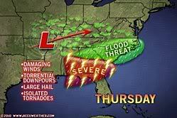
quote:Severe thunderstorms will continue to push across southern Alabama, northern Florida and southern Georgia today into this evening. The cities of Albany, Tallahassee, Jacksonville and Savannah will be threatened.
Click the graphic for the latest watches and warnings.A locally strong thunderstorm or two cannot be ruled out over the Tennessee Valley this afternoon.
The strongest thunderstorms will be capable of producing powerful winds, hail and frequent lightning. The winds could lead to downed trees, property damage and overturned semi-trucks.
An isolated tornado or two could touch down and cause destruction, but there will likely not be a repeat of Wednesday's tornado outbreak.
Flooding downpours will also accompany the thunderstorms, while heavy rain spreads over the rest of the Tennessee Valley and Carolinas. In both instances, flash flooding could ensue.
[ Bericht 4% gewijzigd door #ANONIEM op 21-01-2010 13:25:50 ]
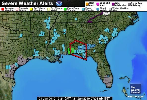

Er staan op dit moment een aantal 'warnings' uit. Onder andere 3 tornado warnings in het noorden van Florida.
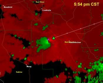
quote:Damaging tornadoes already reported in East Texas and Louisiana
Written by Reed Timmer
Wednesday, 20 January 2010 18:39
Supercells with a history of damaging tornadoes are underway over parts of East Texas and Louisiana this evening along and ahead of a strong cold front plowing across the Southern Plains.
The image shows a 100+ knot gate-to-gate couplet from a tornadic supercell in Natchitoches County, LA at 5:54 pm CST, which was likely producing a large, violent tornado at the time of this image. Damage to homes and large trees down have been reported from tornadoes in Van Zandt and Harrison Counties, TX from a tornadic supercell that has since moved across the Shreveport area into northern Louisiana. It is going to be a long night over East Texas and Louisiana for tornadoes, so stay tuned to local media and be sure to have your weather radio turned on if you live in this region.
1 Tornado heeft de nodige schade aangericht in Texas, gelukkig geen slachtoffers.
quote:One tornado on Wednesday slammed Waskom, Texas, which is just west of Shreveport, La. The twister destroyed homes and businesses, as well as downed trees across Interstate 20.
Closer to Dallas, another tornado littered Interstate 20 with power lines and debris near Canton, Texas. The Associated Press reports that officials were forced to close the interstate for several hours. Multiple homes northeast of Canton were damaged and several people sustained minor injuries.
Fortunately, there have been no reports of deaths from Wednesday's outbreak.
bron + Videoquote:(CNN) -- At least five homes were destroyed after a tornado touched down in western Oklahoma Monday evening, authorities said. There were no reports of injuries.
Other homes were damaged, and power was out to about 900 residences in and around the city of Hammon in Roger Mills County, Oklahoma, Michelann Ooten of the Department of Emergency Management said.
Roger Mills officials continued to assess the damage, but all residents appear to be accounted for, Ooten said.
The tornado hit about 5:30 p.m. (6:30 p.m. ET), said Ken Gallant, lead forecaster for the National Weather Service in Norman, Oklahoma.
The thunderstorms that produced the conditions for the tornado weakened shortly afterward and a tornado warning was canceled, Gallant said.
Jerry Dean, county commissioner of Roger Mills, said the county barn was among the structures destroyed.
Area residents had time to prepare before the tornado hit, Dean said.
He could see the tornado coming before going into a cellar to wait it out, he said.
[ Bericht 1% gewijzigd door #ANONIEM op 09-03-2010 10:51:34 ]


quote:Dangerous Thunderstorms Take Aim at Lower Mississippi
.One or more rounds of powerful, potentially dangerous and destructive thunderstorms will fire from portions of eastern Texas to Arkansas, Louisiana, Missouri, Mississippi and Alabama into tonight.
Many of the storms will bring strong, gusty winds, blinding downpours, small hail and cloud to ground lightning strikes. However, a handful of the storms can bring damaging wind gusts, golf-ball sized hail and flash flooding. The strongest of the storms may spawn tornadoes.
While only a few tornadoes are expected during this outbreak, even one tornado in a populated area could lead to loss of life and devastation.
The storms rolled through the Dallas-Fort Worth Metroplex at midday with downpours and brief gusty winds. However the line of storms has had a recent history of producing golf ball-sized hail in parts of Texas.
Additional lines of thunderstorms will fire and progress to the east into the evening.
AccuWeather.com meteorologists are concerned this early season outbreak may catch people off guard.
If you live or are traveling through this area, be prepared for delays as the storms roll through.
If severe weather approaches your location, seek shelter immediately.
Remember to stay away from windows in your home, school or office. Do not attempt to drive through flooded roadways.
Een aantal (zwaar) gewonden, complete huizen verwoest en hagelstenen zo groot als golfballen.
Three tornadoes hit Arkansas
Three tornadoes hit Arkansas
quote:(CNN) -- Parts of Arkansas were under a tornado watch until early Thursday after a series of powerful tornadoes ripped through dozens of homes, critically injuring two people.
The first twister struck in Saline County in central Arkansas at 7:28 p.m. ET Wednesday, the National Weather Service said. The tornado damaged 22 homes, an Arkansas Emergency Management spokeswoman said.
A woman in the area said she could hear the storm roaring as it approached the area.
"It was the awfulest roaring I ever heard in my life," the woman told CNN affiliate KTHV. "My house felt like it was fixing to crumble over me."
Another tornado struck north of Saline in White County at 9:25 p.m. ET, the weather service said. That storm damaged 9 homes and injured one person.
A third tornado struck in nearby Cleburne County at 10:05 p.m. ET. Emergency officials were still trying to determine the full extent of the damage hours after the twister hit the area. Several homes were damaged or destroyed and three people were injured. Two were critically injured, said Renee Preslar, spokeswoman for the Arkansas Department of Emergency Management.
Along with tornadoes, central Arkansas was raked by powerful thunderstorms and golf ball-size hail, the National Weather Service said.
"The storm seems to be shifting to the east so the severe weather should be out of this area by [Thursday]," said John Lewis, a senior forecaster with an Arkansas office of the National Weather Service.
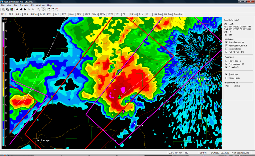
Die tornado's komen van deze supercell. Heb gisteravond deze bui een tijdje gevolgd via de radar. Was niet te missen.quote:Op donderdag 11 maart 2010 10:30 schreef aloa het volgende:
Een aantal (zwaar) gewonden, complete huizen verwoest en hagelstenen zo groot als golfballen.
Three tornadoes hit Arkansas
[..]
Half miljoen huizen in VS zonder stroom door storm
(Novum) - Door rukwinden en zware regen zitten meer dan een half miljoen huizen en bedrijven in het noordoosten van de Verenigde Staten zonder stroom. Internationale vluchten lopen uren vertraging op en een trein richting New York met vijfhonderd passagiers stond meer dan vijf uur stil.
Een diesellocomotief heeft de trein uiteindelijk naar het volgende station gesleept, waarop de passagiers de reis met de bus konden vervolgen.
Het is de tweede keer in een week tijd dat meer dan een half miljoen huizen en bedrijfspanden door de storm zonder stroom komen te zitten. Door de rukwinden vallen bomen om en knappen elektriciteitsdraden. New York en New Jersey zijn het zwaarst getroffen, maar ook in delen van Pennsylvanië en Connecticut is de stroom uitgevallen.
Negen vliegtuigen die in New York hadden moeten landen zijn uitgeweken naar Boston, omdat ze niet genoeg brandstof hadden om nog langer te wachten op beter weer in New York. Onder de uitgeweken vliegtuigen was een Airbus A-380, het grootste commerciële passagiersvliegtuig ter wereld.
In Atlantic City viel een kraan om op een bouwplaats. Opvliegend puin vloog door het raam van een politiewagen, waardoor een agent gewond raakte.
bron
Klassieke haak.quote:Op donderdag 11 maart 2010 12:48 schreef i2Them2 het volgende:
[..]
Die tornado's komen van deze supercell. Heb gisteravond deze bui een tijdje gevolgd via de radar. Was niet te missen.
[ afbeelding ]
's Avonds een man, overdags rustig an

Honderdduizenden mensen zaten in de regio van New York door orkaanachtige stormen en hevige regen tijdelijk zonder stroom. Volgens de New York Times Online werden twee mensen gedood door ontwortelde bomen in Teaneck in de staat New Jersey. Een brand verwoestte verschillende historische huizen in de badplaats Ocean Grove aan de Atlantische Oceaan.
Het luchtverkeer werd verstoord en liep vertragingen op. Wegens de felle wind werd ook het treinverkeer tussen New York en Philadelphia onderbroken. Regionale spoorwegverbindingen werden eveneens getroffen net zoals delen van de New Yorkse metro en ook het busverkeer. De Staten Island-veerboten bleven meer dan vier uur aan de kade liggen. De elektriciteitsmaatschappij Con Ed deelde mee dat het onduidelijk is wanneer de stroomvoorziening volledig hersteld is.
In Pittsburgh hadden weerkundigen al gewaarschuwd voor zware overstromingen. De combinatie van warmer weer en verschillende dagen regen kunnen de sneeuw in de bergen doen smelten, waardoor het waterniveau in de rivieren zal stijgen. In die regio is voorlopig wel minder neerslag gevallen dan verwacht. ( Bron )

aldus Twitter:quote:Strong storms slammed South Florida with rain and high winds Monday morning, possibly causing a tornado that scattered debris over Oakland Park Boulevard near Interstate 95.
The National Weather Service says trained spotters reported a tornado near the area about 8:30 a.m. No other information was available.
The weather service had issued a tornado warning for northeastern Broward County until 8:45 a.m.
Large hail and damaging winds of more than 60 mph are possible.
A tornado watch remains in effect until 11 a.m. for the rest of South Florida.
The weather service cautioned drivers not to try to outrun a tornado. Instead, motorists should leave their vehicles and go into a strong building.
The weather service also issued an urban flood advisory for eastern Broward and southeastern Palm Beach County.
quote:Tornado cuts 5-mile-long swath through Oakland Park., Fla.; thousands left without power - National Weather Service
Zie net deze foto bij een nieuwsbericht staan
Wat een foto
Maar lijkt wel gefotoshopped
Zou dat echt zo kunnen?

Wat een foto
Maar lijkt wel gefotoshopped
Zou dat echt zo kunnen?
quote:Twisters rip through south
Severe storms hammered North Carolina on Sunday evening, but no fatalities had been reported as of Monday morning, and injuries were minor, officials said.
Residents reported as many as eight tornadoes touching down–overturning mobile homes, ripping out trees and plunging neighborhoods into darkness.
Survey crews were meeting with local officials throughout the state to get a clearer picture of the storm damage, said Ernie Seneca, spokesman for the North Carolina Department of Crime Control and Public Safety. There were reports of damaged houses and downed trees, but injuries were limited, he said.
“It looks like people heeded the warning to seek shelter when the storm came,” he said.
“It really did sound like a train. It was pure noise,” said William Schlaeppi, who lives on a farm in High Point, North Carolina, where the National Weather Service reported damage to at least 20 homes. “I literally watched my fields disappear in front of me under a wall of water–circular, spinning water.”
Strong storms slammed South Florida with rain and high winds Monday morning, possibly causing a tornado that scattered debris over Oakland Park Boulevard near Interstate 95.
A tornado touched down in Oakland Park, Florida, just north of Fort Lauderdale, between 8 and 8:30 a.m. Monday, said Tyrone Mosley, a weather service specialist. There was debris but no immediate report of injuries, he said.
In North Carolina, at least eight unconfirmed tornadoes were spotted along the Interstate 85 corridor between Charlotte and Greensboro on Sunday evening.
Metal roofing was ripped off an industrial building in Belmont, west of Charlotte, littering nearby trees with clumps of yellow insulation.
Het ziet er wel echt uit, die foto.quote:Op maandag 29 maart 2010 20:25 schreef Frutsel het volgende:
Zie net deze foto bij een nieuwsbericht staan
[ afbeelding ]
Wat een foto
Maar lijkt wel gefotoshopped
Zou dat echt zo kunnen?
[..]
http://images.google.nl/images?hl=nl&source=hp&q=tornado&gbv=2&aq=f&aqi=g10&aql=&oq=&gs_rfai=
[ Bericht 15% gewijzigd door #ANONIEM op 29-03-2010 21:16:02 ]
Ah okay!quote:Op maandag 29 maart 2010 21:14 schreef aloa het volgende:
[..]
Het ziet er wel echt uit, die foto.
http://images.google.nl/images?hl=nl&source=hp&q=tornado&gbv=2&aq=f&aqi=g10&aql=&oq=&gs_rfai=
Maar hij hoort dus niet bij het nieuws van net
Neequote:Op maandag 29 maart 2010 21:26 schreef Frutsel het volgende:
[..]
Ah okay!
Maar hij hoort dus niet bij het nieuws van net
Sommige sites gebruiken vaak oude foto's bij dergelijke items.
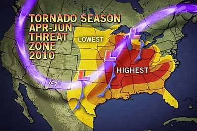
quote:This year's tornado season is expected to shift farther eastward into the Midwest and become more active in late April through June.
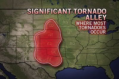
The greatest concentration of tornadoes is reported between March and August each year in "Tornado Alley," which includes portions of Texas, Oklahoma, Kansas, Nebraska and South Dakota.
This spring, AccuWeather.com meteorologists expect tornado activity will increase farther east into the Midwest instead of the traditional Tornado Alley.
Tornado season usually begins in March, but this year, there has been a lack of tornadoes. A total of 64 tornadoes have occurred as of March 29. On average, 225 tornadoes occur by this date.
Several reasons account for the lack for tornadoes in 2010, an El Niño year.
1. A cooler-than-normal Gulf of Mexico.
2. Jet stream displaced farther south than normal due to the El Niño.
3. Persistent cool weather in the Plains and South.
The frequency of tornadoes will increase as the El Niño begins to weaken and the Gulf of Mexico sea surface temperatures warm.
quote:The Midwest appears particularly primed for additional tornado outbreaks this year rather than the typical Tornado Alley states because of the predicted storm track and the proximity of Gulf moisture should be present by late April.
AccuWeather.com analyzed tornado reports dating back to 1950 from the Storm Prediction Center during April, May and June of 1958, 1966, 1978, 1988, 1993, 1995 and 2003, the most recent years categorized as El Niño events.
Two patterns emerged from this information: many states had fewer tornadoes reported early in severe weather season than normal, and then higher totals emerged in the following months for some states.
In April, the southern tier of states, including Oklahoma, Texas, Louisiana, Mississippi, Alabama and Florida, reported an increased number of tornadoes than they typically see. Meanwhile, nearly all states to the north of that line saw fewer twisters in El Niño years.
However, the severe weather often returned with a vengeance in the states lining the Mississippi River and many Southern states in May, as a much higher-than-normal amount of tornado reports occurred in those years.
Once June arrives, tornado activity begins to normalize overall across the country. The one exception is South Dakota, which has seen nearly double the amount of twisters in June El Niño years than others.
De komende week gaat het spannend worden. Er zijn t/m woensdag toch wel wat kansen op severe weather. April/Mei zal toch de maand moeten worden waarin het losbarst na het rustige 2009. Ik ben erg benieuwd.
Heb zojuist de season finale gezien van Storm Chasers 2009... Wat lijkt het mij toch gaaf om een keer mee te gaan op zo'n chase!
Heb zojuist de season finale gezien van Storm Chasers 2009... Wat lijkt het mij toch gaaf om een keer mee te gaan op zo'n chase!
's Avonds een man, overdags rustig an
Jep, alleen al daar zitten en tijdens tv programma's opeens die chasers op tv zien met prachtige beelden is al gruwelijk genoegquote:Op zondag 4 april 2010 22:07 schreef Burnie88 het volgende:
De komende week gaat het spannend worden. Er zijn t/m woensdag toch wel wat kansen op severe weather. April/Mei zal toch de maand moeten worden waarin het losbarst na het rustige 2009. Ik ben erg benieuwd.
Heb zojuist de season finale gezien van Storm Chasers 2009... Wat lijkt het mij toch gaaf om een keer mee te gaan op zo'n chase!