WKN Weer, Klimaat en Natuurrampen
Lees alles over het onstuimige weer op onze planeet, volg orkanen en tornado's, zie hoe vulkanen uitbarsten en hoe Moeder Aarde beeft bij een aardbeving. Alles over de verwoestende kracht van onze planeet en tal van andere natuurverschijnselen.


Extreem weer in de V.S.
De Verenigde Staten kennen extreme weersituaties. Tornado's en orkanen eisen elk jaar tientallen levens. Plotseling opkomende onweersbuien zijn vooral in Florida gevaarlijk. In bergachtige gebieden en in woestijnen neemt de grond weinig water op en veranderen beekjes als gevolg van hevige regenval plotseling in kolkende watermassa's.
Tornado's
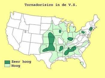
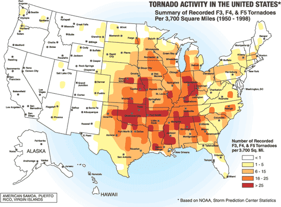
Tornado's ontstaan overal in de Verenigde Staten, maar het merendeel ten oosten van de Rocky Mountains in Texas, Kansas en Oklahoma, ook wel Tornado Alley genoemd. Jaarlijks razen ongeveer 1000 tornado's over de Verenigde Staten.
Er zijn twee tornadoseizoenen. De eerste is in april en mei en het tweede in november. In november beperken de tornado's zich tot Alabama, Mississippi en Louisiana.
Florida is berucht wegens het grote aantal onweersdagen. In Lightning Alley onweert het op meer dan 90 dagen per jaar.
Deel1: Weeralarm VS: Ongewoon zwaar tornadoseizoen
Amerikaanse weerinstituut National Weather Service
Voor orkanen is er: Hurricane Season 2008:Very active season ahead
Foto Greensburg voor en na de Tornado Ramp
[ Bericht 2% gewijzigd door #ANONIEM op 13-06-2008 16:25:22 ]
De Verenigde Staten kennen extreme weersituaties. Tornado's en orkanen eisen elk jaar tientallen levens. Plotseling opkomende onweersbuien zijn vooral in Florida gevaarlijk. In bergachtige gebieden en in woestijnen neemt de grond weinig water op en veranderen beekjes als gevolg van hevige regenval plotseling in kolkende watermassa's.
Tornado's
Tornado's ontstaan overal in de Verenigde Staten, maar het merendeel ten oosten van de Rocky Mountains in Texas, Kansas en Oklahoma, ook wel Tornado Alley genoemd. Jaarlijks razen ongeveer 1000 tornado's over de Verenigde Staten.
Er zijn twee tornadoseizoenen. De eerste is in april en mei en het tweede in november. In november beperken de tornado's zich tot Alabama, Mississippi en Louisiana.
Florida is berucht wegens het grote aantal onweersdagen. In Lightning Alley onweert het op meer dan 90 dagen per jaar.
Nieuwsberichten, foto's, filmpjes over tornado's, onweer, overstromingen etc etc kun je hier in dit topic kwijt.quote:Tornado Parkersburg tweede EF5 van de eeuw
De tornado die zondagmiddag om 18 uur door Parkersburg in de stad Iowa trok is gedefinieerd als een EF-5 tornado. Daarmee is sprake van de tweede EF5-tornado van deze eeuw. De laatste keer dat dit gebeurde was op 4 mei 2007 in Greensburg (Kansas).
De tornado in Parkersburg was de zwaarste tornado voor Iowa sinds 1976. De tornado trok met windsnelheden van 328 kilometer per uur door het dorp en had een breedte van 800 meter. Daarbij vielen volgens de officiële statistiek van de Nationale Weerdienst 6 doden. 50 mensen raakten gewond.
vwk
Deel1: Weeralarm VS: Ongewoon zwaar tornadoseizoen
Amerikaanse weerinstituut National Weather Service
Voor orkanen is er: Hurricane Season 2008:Very active season ahead
Foto Greensburg voor en na de Tornado Ramp
[ Bericht 2% gewijzigd door #ANONIEM op 13-06-2008 16:25:22 ]
Padvinders gedood door wervelstorm
In de Amerikaanse staat Iowa zijn woensdag (plaatselijke tijd) zeker vier padvinders om het leven gekomen door toedoen van een wervelstorm
Het kamp van de padvinders werd getroffen door een wervelstorm. Naast de vier dodelijk slachtoffers raakten ook nog eens 40 anderen gewond. Dat heeft nieuwszender CNN gemeld.
De scouts waren tussen de dertien en achttien jaar oud.
weeronline
4 Scouts killed as twister rips through camp

Ah, een nieuw deel!
Op zaterdag 15 augustus 2009 23:05 schreef eer-ik het volgende:
Ik vind je sig nogal denigrerend.
Ik vind je sig nogal denigrerend.

Floods in the U.S. Midwest
Heavy rains in early June 2008 soaked the U.S. Midwest, leaving swollen rivers in their wake. By June 8, 2008, the National Weather Service had issued flood warnings for numerous counties throughout Indiana and Illinois. The lower Wabash, White, and East Fork White watersheds had all been affected by the deluge, according to National Weather Service bulletins, and streamflow guages on parts of the White and East Fork White River recorded 100-year-flood levels, according to preliminary reports from the U.S. Geological Survey.
The Moderate Resolution Imaging Spectroradiometer (MODIS) on NASA’s Aqua satellite captured the top image on May 28, 2008, and the bottom image on June 10. These false-color images combine infrared and visible light to enhance the contrast between vegetation (bright green) and water (dark blue). Bare ground is pinkish-tan, and clouds are blue-white. Rivers that were not even visible at MODIS’ resolution on May 28 are wide blue ribbons on June 10. The Embarras, Wabash, White, and East Fork White Rivers are all swollen from the heavy rains.

In bepaalde gebieden de zwaarste overstromingen sinds 1993
bron:quote:Flooding in the Midwest...
Damage from flooding appears likely to reach hundreds of millions of dollars. Roads and bridges have been shut down, crops have been damaged, and officials in some areas fear the worst flooding since 1993. Thousands of homes and hundreds of businesses have been flooded with numerous evacuations, countless roads are flooded and closed, road damage is extensive, and many levees and earthen dams have failed or are in jeopardy of failing.
De Ohio river is niet echt toegenomen zo te zien, plaatselijk regenval dus 
"We meet every day at the same cafe, six-thirty and no one knows she'll be there."
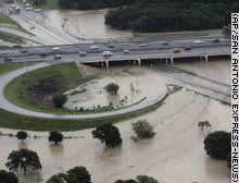
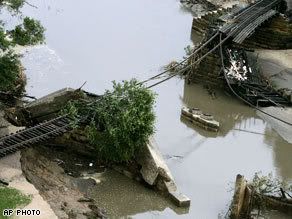
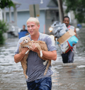
4,000 homes evacuated amid flooding in Cedar Rapids, Iowa
CEDAR RAPIDS, Iowa (AP) -- The Cedar River poured over its banks here Thursday, forcing the evacuation of nearly 4,000 homes, causing a railroad bridge to collapse and leaving cars underwater on downtown streets.
Officials estimated that 100 blocks were underwater in Cedar Rapids, where several days of preparation could not hold back the rain-swollen river. Rescuers had to use boats to reach many stranded residents, and people could be seen dragging suitcases up closed highway exit ramps to escape the water.
"We're just kind of at God's mercy right now, so hopefully people that never prayed before this, it might be a good time to start," Linn County Sheriff Don Zeller said. "We're going to need a lot of prayers, and people are going to need a lot of patience and understanding."
Days of heavy rain across the state have put nine rivers across Iowa at or above historic flood levels. Residents were steeling themselves for floods before storms late Wednesday and early Thursday brought up to 5 inches of rain across west central Iowa.
"We are seeing a historic hydrological event taking place with unprecedented river levels occurring," said Brian Pierce, a meteorologist with the National Weather Service in Davenport. "We're in uncharted territory; this is an event beyond what anybody could even imagine."
Gov. Chet Culver has declared 55 of Iowa's 99 counties to be state disaster areas.
No deaths or serious injuries were reported in Iowa, but one man was killed in southern Minnesota when his car plunged from a washed-out road into floodwaters. Another person was rescued from a nearby vehicle in the town of Albert Lea.
cnn
CEDAR RAPIDS, Iowa (AP) -- The Cedar River poured over its banks here Thursday, forcing the evacuation of nearly 4,000 homes, causing a railroad bridge to collapse and leaving cars underwater on downtown streets.
Officials estimated that 100 blocks were underwater in Cedar Rapids, where several days of preparation could not hold back the rain-swollen river. Rescuers had to use boats to reach many stranded residents, and people could be seen dragging suitcases up closed highway exit ramps to escape the water.
"We're just kind of at God's mercy right now, so hopefully people that never prayed before this, it might be a good time to start," Linn County Sheriff Don Zeller said. "We're going to need a lot of prayers, and people are going to need a lot of patience and understanding."
Days of heavy rain across the state have put nine rivers across Iowa at or above historic flood levels. Residents were steeling themselves for floods before storms late Wednesday and early Thursday brought up to 5 inches of rain across west central Iowa.
"We are seeing a historic hydrological event taking place with unprecedented river levels occurring," said Brian Pierce, a meteorologist with the National Weather Service in Davenport. "We're in uncharted territory; this is an event beyond what anybody could even imagine."
Gov. Chet Culver has declared 55 of Iowa's 99 counties to be state disaster areas.
No deaths or serious injuries were reported in Iowa, but one man was killed in southern Minnesota when his car plunged from a washed-out road into floodwaters. Another person was rescued from a nearby vehicle in the town of Albert Lea.
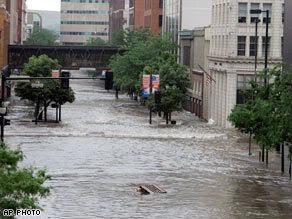
cnn

Idd. Lekkere bende daar...quote:Op vrijdag 13 juni 2008 05:32 schreef kraakvandaal het volgende:
Ze mogen wel eens wat aan dijken gaan doen daar.
zou me niets verbazen als de adviseurs daar dat ook al jaren roepen, maar dat de politiek steeds andere prioriteiten had.quote:Op vrijdag 13 juni 2008 05:32 schreef kraakvandaal het volgende:
Ze mogen wel eens wat aan dijken gaan doen daar.
Bizar dat in Californie de bush-fires vanwege de droogte alweer begonnen zijn, in Aspen kunnen ze skieën, in het midden-westen grote overstromingen en in het oosten hebben ze een hittegolf, allemaal tegelijkertijd...
Kun je, je toch niet voorstellen dat zoiets in de USA kan. Erg slecht dat men daar niet meer aan dijken e.d. doet.
Verschikkelijk voor die mensen daar
Verschikkelijk voor die mensen daar
* I intend to live forever, so far so good! *
http://www.msnbc.msn.com/id/25105715/
quote:Een hittegolf aan de oostkust van de Verenigde Staten heeft in vier dagen tijd al aan meer dan dertig mensen het leven gekost. De meeste slachtoffers zijn bejaarden.
In en rond Philadelphia vielen vijftien doden, onder wie een man die tijdens het zonnebaden een zonnesteek opliep. In New York kwamen zeven mensen om, in Virginia werden ook zeven doden gemeld en in Maryland ten slotte twee. De temperatuur liep op tot hoog in de dertig graden celsius. (DePers)
http://seattletimes.nwsou(...)2_webweather09m.htmlquote:Seattle just experienced the coldest first week of June, according to climate records dating to 1891, said Cliff Mass, University of Washington metrologist. Both 1999 and 2008 share the record, with 1917 falling in second place, he said. "Just wait until tomorrow," he said, when temperatures are going to be even colder.
A heavy snow warning has been issued for the Washington Cascades and Olympics as a storm from the Gulf of Alaska plows into the state tonight.
Forecasters with the National Weather Service said up to a foot of snow may fall in the mountains as low as 3,000 feet, which means Snoqualmie Pass may get a dusting.
State transportation crews will be parking their mowers and driving snowplows.
"We will have crews working through the night, and we'll have extra crews on standby just in case this storm hits hard," said Monty Mills, Washington Department of Transportation maintenance manager for snow and ice operations.
Crews will be on the roads today and tonight applying de-icer as necessary to prevent the road surface from icing up.
The state has four snowplows available over White Pass on Highway 12 and seven on Snoqualmie Pass on Interstate 90.
For the last few weeks, crews have stopped fighting snow to mowing grass, tackling weeds, striping lane lines and sweeping roads. It's back to winter operations tonight.
"In 30 years I can only remember two other times when it snowed this late in the season," said Sam Krahenbuhl, Snoqualmie Pass assistant maintenance superintendent. "One time it snowed on a Fourth of July weekend. This is really rare."
While it won't snow in the Puget Sound area, records for the lowest high temperature may be broken today and Tuesday. Forecasters said the high temperature today should be 57 degrees, 1 degree below the record set last year. On Tuesday, under windy and rainy skies, the temperature should only get to 54 degrees, 2 degrees below the record set in 1972.
"It's not completely unusual to get snow in June," said forecaster Dennis D'Amico. "But this is a lot of snow and it's an unseasonable cold system."
foto's:
http://www.wsutoday.wsu.edu/pages/Publications.asp?Action=Detail&PublicationID=12357&PageID=
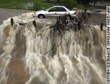
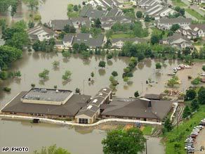
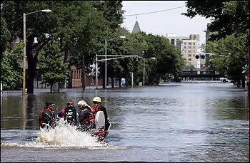
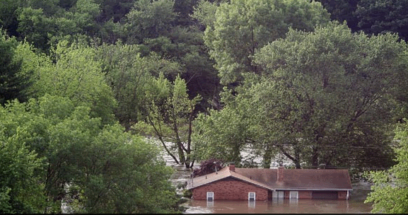
Rising Water Forces Evacuation of Iowa Hospital
Rising water from the Cedar River forced the evacuation of a downtown hospital Friday after residents of more than 3,000 homes fled for higher ground. A railroad bridge collapsed, and 100 city blocks were under water.
The hospital's 176 patients, including about 30 patients in a nursing home facility at the hospital, were being evacuated to other hospitals in the region. The evacuation started late Thursday night and continued Friday morning in the city of 124,000 residents.
"Some are frail and so it's a very delicate process with them," said Karen Vander Sanden, a hospital spokeswoman.
Water was seeping into the hospital's lower levels, where the emergency generator is located, said Dustin Hinrichs of the Linn County emergency operations center.
"They proactively and preventatively started evacuation basically guessing on the fact they were going to lose power," he said.
Dave Koch, a spokesman for the Cedar Rapids fire department, said the river will crest Friday at about 31.8 feet. It was at 30.9 feet early in the morning. In a 1993 flood, considered the worst flood in recent history, it was at 19.27 feet.
ABC
Rising water from the Cedar River forced the evacuation of a downtown hospital Friday after residents of more than 3,000 homes fled for higher ground. A railroad bridge collapsed, and 100 city blocks were under water.
The hospital's 176 patients, including about 30 patients in a nursing home facility at the hospital, were being evacuated to other hospitals in the region. The evacuation started late Thursday night and continued Friday morning in the city of 124,000 residents.
"Some are frail and so it's a very delicate process with them," said Karen Vander Sanden, a hospital spokeswoman.
Water was seeping into the hospital's lower levels, where the emergency generator is located, said Dustin Hinrichs of the Linn County emergency operations center.
"They proactively and preventatively started evacuation basically guessing on the fact they were going to lose power," he said.
Dave Koch, a spokesman for the Cedar Rapids fire department, said the river will crest Friday at about 31.8 feet. It was at 30.9 feet early in the morning. In a 1993 flood, considered the worst flood in recent history, it was at 19.27 feet.

ABC
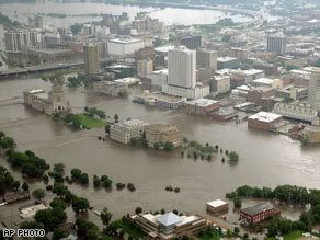
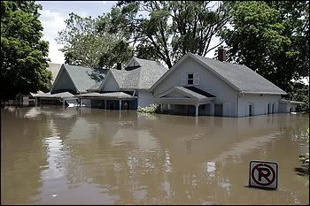
20 doden bij overstromingen in de VS
De Amerikaanse staat Iowa blijft geteisterd door uitzonderlijke overstromingen.
Het noodweer in het centrum van de Verenigde Staten heeft de voorbije weken al aan tenminste twintig mensen het leven gekost.
In Cedar Rapids zijn grote delen van de stad geëvacueerd en het water bedreigt nu ook de hoofdstad Des Moines.
De rivier Cedar trad uit haar oevers en het water stroomde de stad in. Meer dan vierhonderd straten zijn overstroomd en duizenden mensen moesten hun woning verlaten.
Volgens woordvoerder Brett Voorhees van de lokale autoriteiten gaat het om een overstroming "zoals men er maar één in vijfhonderd jaar meemaakt".
vwk
had net m'n vader aan de telefoon en die zei inderdaad dat het al een hele tijd elke dag 35/40 graden is (north carolina)quote:Op vrijdag 13 juni 2008 08:54 schreef Ared het volgende:
[..]
zou me niets verbazen als de adviseurs daar dat ook al jaren roepen, maar dat de politiek steeds andere prioriteiten had.
Bizar dat in Californie de bush-fires vanwege de droogte alweer begonnen zijn, in Aspen kunnen ze skieën, in het midden-westen grote overstromingen en in het oosten hebben ze een hittegolf, allemaal tegelijkertijd...
<a href="https://forum.fok.nl/topic/1321859/1/30" target="_blank" >HuHu en kwiwi hebben een kindje gemaakt</a> O+
Vraag me af, of dat haalbaar is (of het mogelijk is, is zelfs de vraag...). Dat zal in ieder geval een enorm aantal kilometers dijk worden.quote:Op vrijdag 13 juni 2008 05:32 schreef kraakvandaal het volgende:
Ze mogen wel eens wat aan dijken gaan doen daar.
CEDAR RAPIDS, Iowa (CNN) -- Floodwaters started to recede Sunday in Iowa's second-largest city, but more than 20,000 residents were unable to return to their homes and the streets of Cedar Rapids remained inundated.
Hundreds have flocked to shelters, where they expressed concerns about how they are going to rebuild.
"Most of the people here ... do not have flood insurance," said Steve Doser, director of a shelter in Cedar Rapids.
"A couple people told us ... that they were told they didn't need flood insurance. 'Don't worry about it, you're in a 500-year [plain],' " he said. "Now they don't have anything."
The flooding also has affected Cedar Rapids' water treatment plant, which is operating at only 25 percent. Residents have been asked to limit their water usage.
Linn County, where Cedar Rapids is located, is expected to stay above the flood stage until the end of the month, as the water level has already crested and is expected to drop.
Iowa has been inundated with heavy rains in recent weeks, causing several major rivers that feed into the Mississippi -- including the Cedar, Des Moines and Iowa rivers -- to escape their banks.
There have been 16 storm-related deaths since May 25 in Iowa, including one woman found dead in her Cedar Rapids home Saturday, the governor's office said.
The other fatalities include those resulting from tornadoes. Among them are four Boy Scouts killed after a twister hit their camp in western Iowa on Wednesday.
Culver has declared 83 of the state's 99 counties disaster areas and deployed more 2,500 Iowa National Guard troops.
Of those, 750 are stationed in Des Moines helping to shore up levees with sandbags along the Des Moines River amid fears that the historic flooding that has hit other parts of the state could soon take its toll on the capital.
Early Saturday, rising waters breached a levee on the Des Moines River, prompting emergency officials to evacuate 270 homes in Des Moines' Birdland Park neighborhood, a state emergency official said.
A high school in the neighborhood was also flooded.
The flooding caught many people by surprise.
"We didn't think it would get this high," said Tina Fleischacker, whose Cedar Rapids home was devastated by the rising waters. "We moved everything upstairs and it's gone. It's gone. We left with the clothes on our backs."
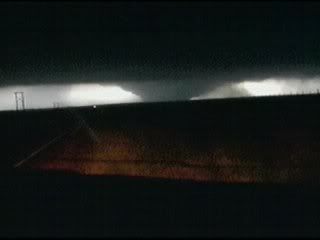
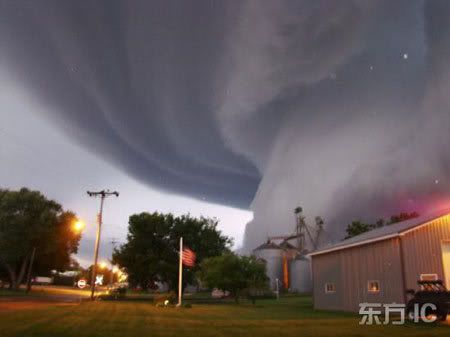
Indrukwekkende tornadofoto uit Iowa
Op internet circuleert een foto van een tornado, die dinsdagavond is genomen door Lori Mehmen in Orchard (Iowa). Woensdagochtend plaatste de Mitchell County Press de foto en later verscheen de foto elders.
Op verschillende fora wordt gesuggereerd dat deze foto niet echt is. Maar googlen op de naam van de fotograaf levert veel hits op in kranten. Indrukwekkend.
vwk
Jij denkt op z'n Nederlands, op zijn Amerikaans gedacht denkt men in privé termen. De ene staat/stad/buurt wel, de andere niet.quote:Op zondag 15 juni 2008 20:06 schreef aloa het volgende:
[..]
Vraag me af, of dat haalbaar is (of het mogelijk is, is zelfs de vraag...). Dat zal in ieder geval een enorm aantal kilometers dijk worden.
Helaas heeft Nederland te lang in het eigen land gedacht. Nu wordt er dan wel aan die expertise verdiend en kan men tevens helder laten zien wat er te koop is aan bescherming. New Orleans bijvoorbeeld.
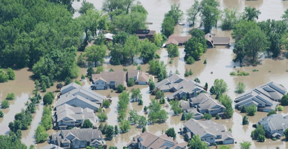
Floods in the U.S. Midwest
Take just three days apart, these images illustrate the rapid rise of water levels on the Mississippi River. The glut of water that had swelled Iowa’s rivers drained in to the Mississippi, raising water levels to dangerous levels. The National Weather Service reported major flooding—record flooding in some cases—at gauges on the Mississippi from Iowa nearly to St. Louis, Missouri.
Captured by the Moderate Resolution Imaging Spectroradiometer (MODIS) on NASA’s Terra satellite, these images show the extent of the flooding across most of the flood region. The large images show additional flooding along the Mississippi River. Water in these false-color images is black, while plant-covered land is green, and bare ground is tan. Clouds are light blue and white. Large bulges punctuate the Mississippi River in the June 17 image (top) where the river flowed over its banks. One of the new bulges threatens the town of Gulfport, Illinois, where a levee burst early on June 17, reported CNN. The river is also wider on June 17 than it had been three days earlier.

quote:Op dinsdag 17 juni 2008 19:57 schreef aloa het volgende:
Indrukwekkende tornadofoto uit Iowa
Op internet circuleert een foto van een tornado, die dinsdagavond is genomen door Lori Mehmen in Orchard (Iowa). Woensdagochtend plaatste de Mitchell County Press de foto en later verscheen de foto elders.
Op verschillende fora wordt gesuggereerd dat deze foto niet echt is. Maar googlen op de naam van de fotograaf levert veel hits op in kranten. Indrukwekkend.
[ afbeelding ]
vwk

2008: al 1300 twisters in de VS, aantal doden staat op 115
“This year may set records for tornadoes and tornado-related deaths” bericht Greg Carbin van NOAA’s Storm Prediction Center in Norman, Oklahoma. Tornado’s hebben dit jaar in de VS al aan 115 mensen het leven gekost. Sinds de grote ‘super tornado outbreak’ in 1974 is het maar twee keer eerder voorgekomen dat er meer dan 100 slachtoffers vielen te betreuren: in 1994 vielen er 122, in 1998 132 doden. Dat er dit jaar zoveel doden zijn, is voor een belangrijk deel te wijten aan de 87 twisters die op 5-6 februari over de Tennessee valley en de Midwest raasden. Deze vroege, catastrofale start van het seizoen kostte maar liefst 56 mensen het leven. Het totaal aantal tornado's dit jaar bedraagt al circa 1300: in een doorsnee kalenderjaar zijn dat er circa 1200.
Verder zijn de meteorologische condities aanmerkelijk ‘gunstiger’ voor het ontstaan van tornado’s (twisters) dan de afgelopen jaren. Volgens Greg Carbin is er normaal gesproken wekelijks een ‘major storm’ (actieve depressie) ergens in de VS actief, gedurende het voorjaar en de voorzomer van dit jaar is dat eens in de 3-4 dagen het geval. Ongetwijfeld heeft een en ander ook te maken met de standvastige kou in de High Plains (onder meer Wyoming).
Jan Visser

http://refdag.nl/artikel/1347950/Dijkdoorbraken+Mississippi.htmlquote:Dijkdoorbraken Mississippi
WASHINGTON (ANP) – Talrijke plaatsen in het westen van de Amerikaanse staat Illinois zijn overstroomd na twee dijkdoorbraken langs de Mississippi. In het aangrenzende Missouri bereiden veel inwoners zich voor op wateroverlast na extreme regenval, meldden Amerikaanse media woensdag.
Met miljoenen zandzakken wordt geprobeerd zwakke dammen en dijken te versterken. De Amerikaanse president George Bush brengt donderdag een bezoek aan de door overstromingen getroffen gebieden. Het midden–westen van de Verenigde Staten lijdt onder de ergste watersnood in vijftien jaar. Ook in Iowa staan grote landbouwgebieden onder water. De schade wordt nu al op 1,5 miljard dollar geschat.
De Amerikaanse president George Bush brengt donderdag een bezoek aan de door overstromingen getroffen gebieden. De schade wordt nu al op zeker 3 miljard dollar (1,9 miljard euro) geschat. Zeker 2 miljoen hectare landbouwgrond zijn verwoest. Het grootste gedeelte van het getroffen gebied is dun bevolkt.
Op zaterdag 15 augustus 2009 23:05 schreef eer-ik het volgende:
Ik vind je sig nogal denigrerend.
Ik vind je sig nogal denigrerend.
http://www.nieuwsblad.be/(...)leid=DMF19062008_049quote:Al 20 dijken aan de Mississippi overstroomd
WASHINGTON - Na dagenlange overstromingen zijn al twintig dijken aan de Amerikaanse rivier Mississippi gebroken. De schade aan de oogsten is enorm. Experts schatten de voorlopige schade op 1,9 miljard euro.
Het overstromingsgevaar is nog niet voorbij. Het leger is ingezet om te voorkomen dat aan de belangrijkste waterloop van de Verenigde Staten nog 20 tot 30 dijken overstromen of doorbreken.
De meeste getroffen en bedreigde gebieden aan de stroom zijn slechts dunbevolkt. Naast de Mississippi ligt vooral landbouw- en industriegrond. Slechts enkele kleine dorpjes moesten geëvacueerd worden.
Op vele plaatsen waren vrijwilligers miljoenen zandzakjes aan het vullen. Het blijft waarschijnlijk tot het weekend regenen. Pas dan kan men de volledige omvang van de schade inschatten.
2 of 20 dijken... klein verschil...
Op zaterdag 15 augustus 2009 23:05 schreef eer-ik het volgende:
Ik vind je sig nogal denigrerend.
Ik vind je sig nogal denigrerend.
Ik vraag me serieus af of dit wel een tornado is... volgens mij is een shelf die erg laag zit.quote:Op dinsdag 17 juni 2008 19:57 schreef aloa het volgende:
Indrukwekkende tornadofoto uit Iowa
Op internet circuleert een foto van een tornado, die dinsdagavond is genomen door Lori Mehmen in Orchard (Iowa). Woensdagochtend plaatste de Mitchell County Press de foto en later verscheen de foto elders.
Op verschillende fora wordt gesuggereerd dat deze foto niet echt is. Maar googlen op de naam van de fotograaf levert veel hits op in kranten. Indrukwekkend.
[ afbeelding ]
vwk
* I intend to live forever, so far so good! *

Lijkt me idd ook een shelf die laag zit icm wat vertekening. Wel een gaafe fotoquote:Op donderdag 19 juni 2008 16:21 schreef IkWilbert het volgende:
[..]
Ik vraag me serieus af of dit wel een tornado is... volgens mij is een shelf die erg laag zit.
Eerste tornadodode New Hampshire sinds 1950
Bij een krachtige EF-2 tornado donderdag in New Hampshire is één dode gevallen. Het komt niet vaak voor dat zo ver noordelijk doden vallen door tornado’s.
De tornado van donderdag was er één van de 15 die deze dag in de Verenigde Staten werden waargenomen. De tornado trok een spoor van 60 kilometer door elf dorpen en stadjes en duurde bijna één uur. Hierbij ontstond een schadespoor van plaatselijk 500 meter breed.
Vooral bomen liepen schade op. Volgens de lokale meteorologische dienst werden duizenden bomen getroffen. In totaal kregen 200 huizen met schade te maken en werden 12 huizen vernietigd. Daarbij overleed een 57-jarige vrouw. Ze werd in het puin naast een drie maanden oude baby gevonden, die had beschermd. Ze is daarmee de 120e tornadodode van dit jaar.
New Hampshire wordt niet vaak door tornado’s getroffen. Uit raadplegingen in historische databases blijkt dat dit de eerste dode is in de staat sinds 1950, toen de statistieken begonnen.
vwk
NYC issues public warning; urges people to seek shelter as the NWS issues a rare tornado warning; tornado will be near City Island by 5.40pm


Het zou wel zorgen voor wat spectaculaire beelden natuurlijk 

"Whatever the mind of man can conceive and believe, it can achieve" Napoleon Hill
Dat zal wel meevallen, die waarschuwingen krijgen wij ook wel eens. NY is niet echt een 'tornado staat' dus ik denk dat ze het wat overdrijven.quote:Op zaterdag 16 augustus 2008 01:00 schreef Drugshond het volgende:
NYC issues public warning; urges people to seek shelter as the NWS issues a rare tornado warning; tornado will be near City Island by 5.40pm
Heb er nu al twee op afstand gezien, wel indrukwekkend.
Patience is not one of my virtues, neither is memory. Or patience for that matter.

Oeps, dubbel is niet nodig.
[b]Op dinsdag 27 januari 2009 21:01 schreef MariaEtcetera het volgende:[/b]
We zijn gewoon een topic vol dysfunctional awesomeness! And proud of it!
We zijn gewoon een topic vol dysfunctional awesomeness! And proud of it!
Hoe zou het aflopen met de tornado's in Denver, icm de conventie?
quote:Gisteren, op de vooravond van de opening van de Democratische conventie, hebben enkele tornado's toegeslaan in de rand rond Denver in de staat Colorado, meldde het Amerikaanse metereologische agentschap NWS.
Het NWS heeft tornadowaarschuwingen verspreid voor vier gebieden in het zuiden en het oosten van Denver, maar niet voor de stad zelf waar vandaag de grote Democratische Conventie start die Barack Obama zal lanceren als presidentskandidaat.
Draaiende stofwolk
De lokale televisiezender KUSA heeft indrukwekkende beelden getoond van een draaiende stofwolk vlakbij Parker, zo'n 40 kilometer ten zuidoosten van het centrum van Denver. Er zijn nog geen berichten opgedoken over eventuele schade.
Ongeveer 50.000 mensen hebben zich in de hoofdstad van Colorado verzameld voor de conventie die vier dagen zal duren. Obama zal donderdag in een openluchtstadion met 75.000 zitplaatsen een speech geven ter gelegenheid van deze conventie.
Bidden
Op 12 augustus heeft een fundamentalistische christelijke groep opgeroepen om te bidden voor stortregens in Denver op de dag van de speech van Barack Obama. (afp/adv)
[b]Op dinsdag 27 januari 2009 21:01 schreef MariaEtcetera het volgende:[/b]
We zijn gewoon een topic vol dysfunctional awesomeness! And proud of it!
We zijn gewoon een topic vol dysfunctional awesomeness! And proud of it!
quote:BISMARCK, N.D. — President Barack Obama declared North Dakota a federal disaster area because of statewide flooding late Tuesday.
In eastern North Dakota, Fargo residents are rushing to build dikes to head off a Red River flood crest of 39 to 41 feet on Friday. The river's flood stage in Fargo is 18 feet.
Meanwhile, some south Bismarck residents who live near the Missouri River were forced to evacuate their homes when an ice jam caused unexpected flooding. A demolition team may attempt to break up the ice jam.
A major winter storm raised flood fears for Bismarck on the Missouri River on Tuesday, even as communities 200 miles to the east along the Red River fought to hold back rising waters there.
Sen. Kent Conrad, D-N.D., called Bismarck "the most urgent threat" in North Dakota because of ice jams north and south of town and heavy snow forecast.
The Army Corps of Engineers cut water releases Tuesday from the Garrison Dam, about 50 miles upriver from Bismarck. The city also ordered the evacuation of homes along the river where access roads were under water in the middle of the spring blizzard. It wasn't immediately clear how many homes.
Authorities also transferred 146 inmates from the Missouri River Correctional Center, a medium-security prison along the Missouri River, to the main state penitentiary. Deputy warden Patrick Branson said the river was close enough that officials "felt we had to get all those guys out of there."
The National Weather Service forecast 8 to 14 inches of snow for much of central and western North Dakota, including Bismarck, with up to 20 inches in some spots.
Meanwhile, the Red River approached a lower-than-expected crest Tuesday in Wahpeton, but the National Weather Service only tweaked its projections for a record crest 30 miles downstream in Fargo, where sandbaggers were working furiously to raise the city's protective dikes high enough
Rest of the Story...
More pictures


Vanavond (lokale tijd) weer severe weather verwacht richting Texas. Over 4 dagen kan de hel losbarsten met een moderate risk.
's Avonds een man, overdags rustig an
Over 4 dagen? Dat zien ze dan in elk geval mooi op tijd. Tornado's enzo? Of wat?quote:Op woensdag 25 maart 2009 20:04 schreef Burnie88 het volgende:
Vanavond (lokale tijd) weer severe weather verwacht richting Texas. Over 4 dagen kan de hel losbarsten met een moderate risk.
Ja tornado's enzo. Supercells in ieder geval.quote:Op woensdag 25 maart 2009 20:18 schreef Frutsel het volgende:
[..]
Over 4 dagen? Dat zien ze dan in elk geval mooi op tijd. Tornado's enzo? Of wat?
http://www.spc.noaa.gov/products/exper/day4-8/
's Avonds een man, overdags rustig an
Op het moment een tornado-warning in Mason, Texas.
Is toch een leuk celletje:
Hier kan je enkele chasers volgen: http://tornadovideos.net/full-screen-chaser-video.php
[ Bericht 30% gewijzigd door i2Them2 op 25-03-2009 22:21:47 ]
Is toch een leuk celletje:
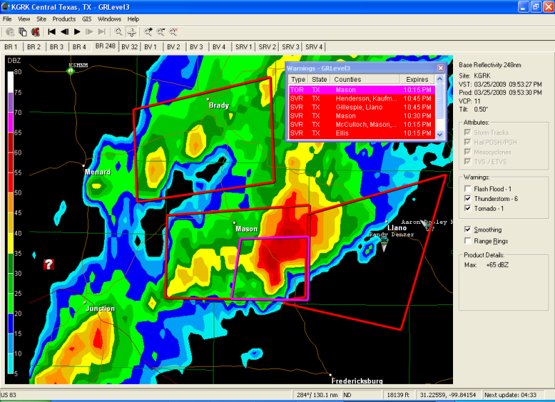
Hier kan je enkele chasers volgen: http://tornadovideos.net/full-screen-chaser-video.php
[ Bericht 30% gewijzigd door i2Them2 op 25-03-2009 22:21:47 ]
Zijn mooie beelden. Jammer dat de duisternis daar zal gaan invallen binnen 2 uur.
's Avonds een man, overdags rustig an
Tering, het gaat los daar! http://www.spc.noaa.gov/exper/mesoanalysis/frames.php?sector=1
's Avonds een man, overdags rustig an
Hmm das helaas een eind van me vandaan. Als er iets in Oklahoma is ga ik proberen wat filmpjes te maken 
IJsdammen...quote:In delen van de Amerikaanse staat Noord-Dakota is de noodtoestand uitgeroepen vanwege hoogwater. Het gebied wordt geteisterd door zware overstromingen als gevolg van onophoudelijke regenval. Verder dreigt de Missouri buiten haar oevers te treden.
Wegen en bruggen in het gebied zijn al afgesloten en duizenden vrijwilligers zijn in de weer met zandzakken om de dijken te verstevigen.
Mensen in laaggelegen gebieden zijn geëvacueerd. Ook 146 gevangenen in de hoofdstad Bismarck van Noord-Dakota moesten naar een andere plaats worden gebracht.
quote:There has been confirmation of a tornado touchdown in Magee, Mississippi, major damage and power outage reported.
quote:No fatalities were immediately reported, but authorities and rescue crews were still responding to the damaged areas north of Magee
quote:'Major damage' reported in possible Magee tornado - Possible twister also hits Madison County
Possible tornadoes struck Simpson and Madison counties early today, leaving extensive damage in their paths.
The Storm Prediction Center in Norman, Okla., which gathers and releases storm reports, said the Magee Police Department reported "major damage" on the north side of Magee after an early morning tornado.
The report from the Police Department also said injuries had been reported, although the extent and number were unknown.
A woman answering the phone at the Simpson County Sheriff's Department just after 2:30 a.m. said no one was available to speak at the time, as emergency officials still were assessing the situation and "just trying to see what we've got."
Phone lines at the Magee Police Department were busy.
Joanne Culin, a meteorologist with the National Weather Service in Jackson, said the agency never likes to say with certainty whether damage is the result of a tornado or straight-line winds until a full assessment can be made.
However, she said regarding the Magee storm that she felt "very confident that that was a tornado."
"The signature on radar was unmistakable," Culin said.
The storm containing the possible tornado rolled through the Simpson County city around 1:45 a.m., part of an intense line of storms ahead of an approaching cold front.
Magee is located about 40 miles south of Jackson on U.S. 49.
Just after midnight, another possible tornado moved out of northern Hinds County in central Mississippi and into southern Madison County, where there were reports of roofs blown off homes in the Annandale and Reunion subdivisions. Many trees and street signs also were reported down in Madison County.
Culin said the weather service received reports that two homes in the Ashbrooke subdivision, located off Rice Road north of the Natchez Trace in Madison, were damaged as was another house near Gluckstadt.
Other damage reported early this morning as the storms marched across Mississippi from west to east included:
Three homes damaged in Madison County's Cherry Hill subdivision.
Numerous trees down and power outages along Mississippi 24 West near Woodville in Wilkinson County.
Trees and power lines down along Mississippi 28 in Copiah County.
Trees down in Utica and Clinton in Hinds County, McNair in Jefferson County, West Lincoln in Lincoln County and Monticello in Lawrence County.
A carport blown away near Raleigh in Smith County.
On Wednesday, the Mississippi Emergency Management Agency reported storm damage in Lauderdale County in east Mississippi.
In that storm, two homes sustained major damage, while nine homes, one business and two barns sustained minor damage. Another business was reported to be a total loss.
MEMA and the National Weather Service urged Mississippians to stay aware of the continuing potential for severe weather through the early morning hours on Saturday.
The weather service said heavy rain, damaging wind and tornadoes will remain possible as a powerful spring storm system continues moving south toward Mississippi. Large hail is also possible, the weather service said.
"Now is the time for every family to make sure their emergency supply kit is well stocked," said Mike Womack, MEMA director. "It is also a perfect time to make sure you have a NOAA weather radio with fresh batteries."
Tevens severe weather verwacht deze nacht en morgen in het gebied Texas/Oklahoma/Kansas. Met name ontzettend veel sneeuw/blizzards. Verwachting rond 10/15cm.
Er is iig genoeg 'winterse'neerslag gevallen:quote:Op vrijdag 27 maart 2009 01:14 schreef Drasss het volgende:
Tevens severe weather verwacht deze nacht en morgen in het gebied Texas/Oklahoma/Kansas. Met name ontzettend veel sneeuw/blizzards. Verwachting rond 10/15cm.
Veel grote hagel (tot 3 inch / 7,6 cm). Verder een tornado melding en op het moment ook twee tornado-warnings plus een aantal severe weather warnings.
Sneeuw viel hier erg tegen. Niet eens een inch. Wel in het westen van de staat Oklahoma plekken die 10 inches of meer op hun donder hebben gekregen.
Helaas is het over 1 a 2 dagen weg omdat het volgende week weer 70F wordt.
Helaas is het over 1 a 2 dagen weg omdat het volgende week weer 70F wordt.
Net ontstond er een prachtige onweersbui boven men schoolcampus ( Oklahoma City )
Hier 1 van de foto's. Alles wat je ziet was eigenlijk aan het draaien..
Hier 1 van de foto's. Alles wat je ziet was eigenlijk aan het draaien..

Morgen (2 april) moderate risks voor tornado's in zuidoost Amerika. Kans op grote tornado's die langdurig van aard zullen worden/zijn. Ik ben heel erg benieuwd, kon wel eens een flinke outbreak gaan worden.
Mooie foto Drasss
Mooie foto Drasss
's Avonds een man, overdags rustig an
Thx Burnie. Zuid-oost ik denk dat Oklahoma net buiten de prijzen gaat vallen, maargoed er komt wel veel regen aan dus wie weet! Hele dag hier al windkracht 6 wat eigenlijk vrij normaal is...
Morgen kans op tornado's ergens rond Texas. Ben benieuwd. Nog niet echt een grote outbreak geweest dit jaar (zal morgen ook niet gebeuren).
's Avonds een man, overdags rustig an
Klopt Burnie. Verwachting is dat Oklahoma donderdagavond kleine kans op onweer heeft. Het zal daarna verder trekken richting het oosten.
Maar! in het weekend verwacht men toch wel wat spektakel. Zaterdag en Zondag grote kans op fikse onweersbuien met tornado's. Even afwachten hoe het eruit ziet rond vrijdag, maar men is nu al kleine waarschuwingen aan het geven.
Maar! in het weekend verwacht men toch wel wat spektakel. Zaterdag en Zondag grote kans op fikse onweersbuien met tornado's. Even afwachten hoe het eruit ziet rond vrijdag, maar men is nu al kleine waarschuwingen aan het geven.
We blijven het in de gaten houden. Voor Norman OK is nu een moderate risk afgegeven, dus kan nog wat worden vanmiddag/vanavond aldaar. Ben benieuwd wat het weekend gaat brengen (hier in NL in ieder geval heerlijk lenteweer).
's Avonds een man, overdags rustig an

Nou in Oklahoma City is alles iig voorbij getrokken. Klein beetje regen gehad, maar niks bijzonders. Alle regen zit nu ten zuiden/oosten van mij vandaan. Ik denk dat Little Rock en omstreken er flink last van gaan krijgen!
Wachten het weekend maar af, dan moet er wat gaan gebeuren
Wachten het weekend maar af, dan moet er wat gaan gebeuren
Nu gaat het ook wel aardig los, mooie onweerslijn aan het ontwikkelen rond Arkansas.
Ik ga het weekend ook maar eens kijken dan
Ik ga het weekend ook maar eens kijken dan
's Avonds een man, overdags rustig an
Waren flinke bosbranden hier in Oklahoma, maar geen tornado's of onweer in de buurt... Wel in andere staten oost van mij.
Zondag op maandag grote kans op tornado's in Texax/Oklahoma/Kansas dus we wachten rustig af...
Zondag op maandag grote kans op tornado's in Texax/Oklahoma/Kansas dus we wachten rustig af...
Maak je ook foto's ?quote:Op vrijdag 10 april 2009 15:59 schreef Drasss het volgende:
Waren flinke bosbranden hier in Oklahoma, maar geen tornado's of onweer in de buurt... Wel in andere staten oost van mij.
Zondag op maandag grote kans op tornado's in Texax/Oklahoma/Kansas dus we wachten rustig af...
Momenteel flink heftig weer in USA, met hoge kans op flinke tornado's en hagel met doorsnee van 3" oftewel 7,5cm
Drugs are good mkay?

Er zijn al enkele tornado's gemeld ja. En hagel (0,75" t/m 3") is daar ook geen probleem:quote:Op vrijdag 10 april 2009 21:23 schreef Party_P het volgende:
Momenteel flink heftig weer in USA, met hoge kans op flinke tornado's en hagel met doorsnee van 3" oftewel 7,5cm
Verder staan er nog genoeg severe-weather/tornado - warnings open.
Ja het is nu erg in Ten. Al 2 doden door verschillende tornado's dicht bijelkaar... en het gaat daar echt los.
Even de naam vergeten 2 posts hierboven. Als ik foto's kan maken dan zal ik ze zeker hier posten. Helaas is het vaak savonds en dan krijg je geen briljante foto's, maar misschien heb ik zondag meer geluk !
Even de naam vergeten 2 posts hierboven. Als ik foto's kan maken dan zal ik ze zeker hier posten. Helaas is het vaak savonds en dan krijg je geen briljante foto's, maar misschien heb ik zondag meer geluk !
Verwoestende tornado trok door Arkansas
Het kleine stadje Mena in de Amerikaanse staat Arkansas is vannacht getroffen door een tornado. Hierbij kwamen drie personen om het leven.
Zeker tien gebouwen, waaronder het gemeentehuis en twee kerken, werden door de tornado verwoest. Ook raakten 24 mensen gewond. Gasleidingen waren lekgeslagen en elektriciteitsmasten omgevallen, net als een aantal bomen.
Kort voor de tornado Mena trof, kwamen iets ten zuiden van het stadje hagelstenen neer met een diameter van acht centimeter -de grootte van een forse appel. Aan de grens met Louisiana en Texas richtte een andere tornado ook fikse schade aan, onder andere aan woonwagens. Alabama, Kentucky, Mississippi en Tennessee hadden te kampen met stroomuitval.
vwk
quote:Op vrijdag 10 april 2009 23:02 schreef Drasss het volgende:
Ja het is nu erg in Ten. Al 2 doden door verschillende tornado's dicht bijelkaar... en het gaat daar echt los.
Even de naam vergeten 2 posts hierboven. Als ik foto's kan maken dan zal ik ze zeker hier posten. Helaas is het vaak savonds en dan krijg je geen briljante foto's, maar misschien heb ik zondag meer geluk !
Blue sky hier en behoorlijk warm ( rond de 18 C ).. Gister was het welliswaar 28 smiddags, savonds misschien maar 5 door een windkracht 7 of 8... ongelofelijk. Alles onder het stof etc.
Tering hee, het gaat los daar! Major warnings door SPC.
I2Them2; waar haal je die mooie data vandaan?
I2Them2; waar haal je die mooie data vandaan?
's Avonds een man, overdags rustig an
Die cellen gingen over mijn hoofd sochtends toen ik nog op 1 oor lag alleen waren ze toen amper regenbui waardig Ongelofelijk en een hel als je er nu inzit.
Ja echt bizar. Op tornadovideos.net kun je live stormchasers volgen (met beeld).
En er gaat een huge supercellop op Atlanta city af.
En er gaat een huge supercellop op Atlanta city af.
's Avonds een man, overdags rustig an
Klopt ik volg het nu ff niet, omdat men laptopdan erg vertraagd. Ze zaten gister allemaal net ten noorden van Ok City.. en gingen richting Kansas... nu maar hopen dat ze straks gierend naar Ok City gaan dan weet ik genoeg wat er gaat gebeuren dit weekend :p
Ik vind het wel raar dat het SPC niets voorspelde voor vanavond, en nu opeens een severe weather forecast.
Is de voorspelling dat het losgaat in OK? Ik ben benieuwd of er nog een F5 aan de grond komt.
Is de voorspelling dat het losgaat in OK? Ik ben benieuwd of er nog een F5 aan de grond komt.
's Avonds een man, overdags rustig an
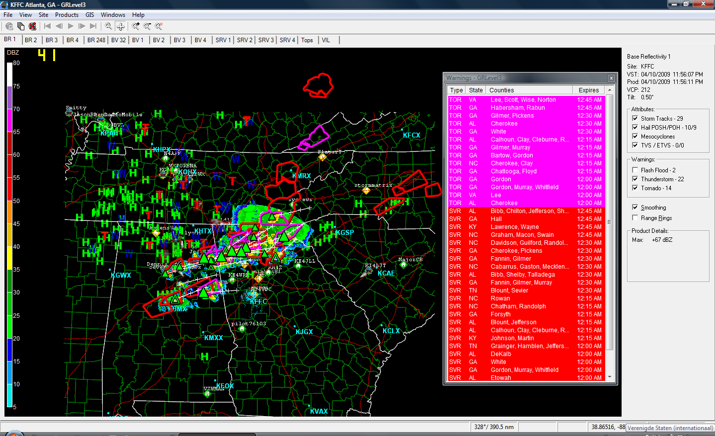
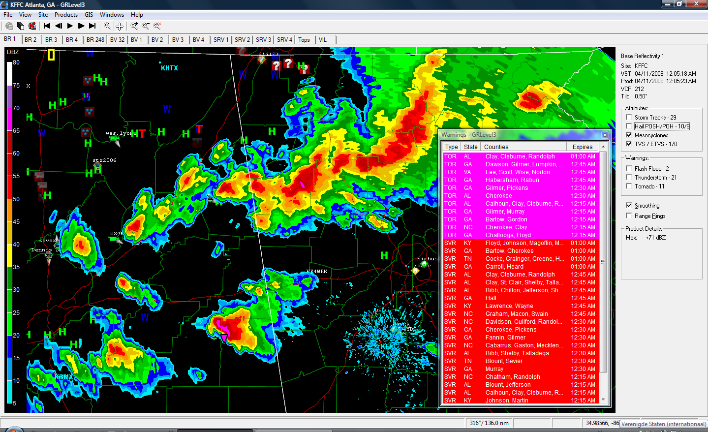
Die mooie data haal ik van het programma GRLevel3. Je kan een demo zo van hun site halen (proeftijd van 21 dagen): http://www.grlevelx.com/grlevel3/ . Er dwaalt trouwens ook nog ergens een torrent rond, zodat je geen tijds-limiet meer hebtquote:Op zaterdag 11 april 2009 00:31 schreef Burnie88 het volgende:
Tering hee, het gaat los daar! Major warnings door SPC.
I2Them2; waar haal je die mooie data vandaan?
Op deze site wordt trouwens in het Nederlands uitgelegd hoe je het programma optimaal kan gebruiken; aanrader: http://www.supercell.nl/grlevel3.html
Het leek net allemaal wat af te zwakken, maar ondertussen zijn er weer een paar pittige cellen bij gekomen.
2 more killed, dozens hurt in Southeastern tornadoes
cnnquote:A tornado descended on Murfreesboro, Tennessee Friday, killing two people and injuring another 30, an official said.
Two people were critically injured by the tornado, which hit the city, located about 30 miles southeast of Nashville, around 1:40 p.m., Donnie Smith, public information officer with the Tennessee Department of Emergency Management in Nashville said.
The search-and-rescue effort was continuing into the evening, Smith said, "so it's possible that may not be all."
Many homes were damaged, others were destroyed and power lines were down across Murfreesboro, said Randy White, a public information officer with Rutherford County Emergency Management.
The bad weather began around noon, when a band of severe thunderstorms swept across the state from the southwest, Smith said.
Elsewhere in the region, the town of Mena, Arkansas, is cleaning up after a tornado roared through, killing three people and damaging or destroying more than 100 homes, an Arkansas official said.
The town looked like a "war zone" as soldiers from the Arkansas National Guard went house to house searching for victims of the twister that hit Thursday night, said Capt. Christopher Heathscott.
About 50 soldiers also helped with security and food distribution.
Gov. Mike Beebe planned to fly over Mena on Friday afternoon.
Mena, population 6,000, took a heavy hit on the west side of town, as the storm swept through downtown before heading up state Highway 71, said Tommy Jackson from the state Department of Emergency Management.
"It looks like a war zone out here," said James Reeves, also from the department. Watch scenes of devastation in Mena »
The tornado damaged the county hospital, Mena City Hall, a middle school, churches, a library, the Masonic lodge and the courthouse -- which houses the 911 emergency dispatch center and a detention center, Reeves said. He said electricity and gas were out in the western half of the city.
Two plants at an industrial park were destroyed, said reporter Charles Crowson of CNN affiliate KTHV-TV. He said utility crews were trying to stop a gas leak there.
Polk County Sheriff Grady Judd told Crowson the county detention center was "uninhabitable." There were 18 inmates in the jail at the time of the tornado, and they were moved to neighboring jurisdictions, he said. iReport.com: Are you there? Send photos, video
There were 24 reports of tornadoes in the area Thursday night, said CNN meteorologist Rob Marciano, and wind gusts reached more than 70 mph.
"So a significant severe weather event last night, and we expect similar action later on today, although it's all moving to the east," he said Friday morning. "It went from Oklahoma across the border toward Arkansas."
Winds will continue to be gusty until later in the afternoon, Marciano said.
As the storms moved east, thunderstorms were predicted, and there was a chance for more tornadoes. Large hail and damaging winds were predicted for the Southeast later Friday.
In Mena, officials set up three shelters, but fewer than 50 people had sought refuge in them. In this rural community, most people are staying with friends and family, Reeves said.
All three victims were elderly, officials said. A man and a woman died when houses collapsed, and another woman died after being struck by debris.
Beebe sent 30 National Guard soldiers to the town Thursday, and 20 more are expected Friday.
Momenteel regen met toch wat onweer er tussen. Paar flinke klappen gehad.
Heel de nacht en morgen zal het zo doorgaan.... Ik vermoed dat vooral zuid Oklahoma/ Texas er last van gaan krijgen en vervolgens de staten oost daarvan. Geen echte tornado waarschuwingen, maar weer regen en onweer...
Heel de nacht en morgen zal het zo doorgaan.... Ik vermoed dat vooral zuid Oklahoma/ Texas er last van gaan krijgen en vervolgens de staten oost daarvan. Geen echte tornado waarschuwingen, maar weer regen en onweer...
Er zijn al weer moderate risk waarschuwingen afgegeven voor Texas (en die kant op) idd. Ben benieuwd.
's Avonds een man, overdags rustig an
Over een klein uurtje komen een aantal cellen bijelkaar en kunnen wat klappen krijgen hier in OK City...
Regen/Hagel/Thunder zit er zeker in maar geen kans op tornado's.
Edit: Enja zoals ik al zei kwam hij er na 30 min aan.... Eigenlijk een best mooie rolwolk of hoe je het ook mag noemen. Helaas is het te donker om hem op een foto te krijgen.. Dang! Ik kan er niks meer van maken hehe.
[ Bericht 27% gewijzigd door Drasss op 13-04-2009 04:15:16 ]
Regen/Hagel/Thunder zit er zeker in maar geen kans op tornado's.
Edit: Enja zoals ik al zei kwam hij er na 30 min aan.... Eigenlijk een best mooie rolwolk of hoe je het ook mag noemen. Helaas is het te donker om hem op een foto te krijgen.. Dang! Ik kan er niks meer van maken hehe.

[ Bericht 27% gewijzigd door Drasss op 13-04-2009 04:15:16 ]
Gaan we weer. Nieuw stormfront opkomst vanuit de Rocky's. Kans op hagel/onweer en misschien een aantal tornado's...
Nogmaals een kickje. As zaterdag tot en met volgende week grote kans op severe weather. Met kans op tornado's/hagel everything... Werd ook weer eens tijd, want na 5 dagen 30 C werd het ook een beetje saai :p
ghehehequote:
Nogmaals een kickje. As zaterdag tot en met volgende week grote kans op severe weather. Met kans op tornado's/hagel everything... Werd ook weer eens tijd, want na 5 dagen 30 C werd het ook een beetje saai :p
High risk is net gegeven aan een groot gebied in Oklahoma. Ik val er echt net buiten en zit in moderate risk.
Nu is het nog prachtig weer hier, de cellen beginnen zicht te ontwikkelen en zullen vanavond afschuwelijk hard toeslaan hoorde ik al.
Gister was het ook al raak in de state met verschillende tornado's op de grens van Kansas-Oklahoma en west van OKC( mijl of 100 )...
Naar mijn weten gaat het maandag pas echt spoken bij mij en zullen we gehit worden door wat storms... ik wacht met spanning af.
Maar eens gaan volgen! Kan nog wat gaan worden.
Ondertussen al genoeg flinke cellen. En oa ook al een funnel gemeld ten oosten van Crawford.
[ Bericht 52% gewijzigd door i2Them2 op 26-04-2009 23:46:31 ]
Ondertussen al genoeg flinke cellen. En oa ook al een funnel gemeld ten oosten van Crawford.
[ Bericht 52% gewijzigd door i2Them2 op 26-04-2009 23:46:31 ]