WKN Weer, Klimaat en Natuurrampen
Lees alles over het onstuimige weer op onze planeet, volg orkanen en tornado's, zie hoe vulkanen uitbarsten en hoe Moeder Aarde beeft bij een aardbeving. Alles over de verwoestende kracht van onze planeet en tal van andere natuurverschijnselen.


Opnieuw een zware orkaan richting de Filipijnen
Opnieuw lijkt het erop dat de Filipijnen te maken krijgen met een zeer zware orkaan. De tropische storm Haiyan ligt op dit moment nog ver op de oceaan maar op dit moment is de verwachting dat de storm dan is uitgegroeid tot een orkaan van vierde categorie.


De landfall van Haiyan wordt vrijdag verwacht en wellicht dat de voorspelling tegen die tijd iets gunstiger zal uitpakken, net als dat de koers van Haiyan nog kan worden bijgesteld.
Het is de zoveelste tropische storm die de Filipijnen in 2013 gaat treffen. Met kleinere impacts in januari en februari van dit jaar kreeg het eiland vooral in de maanden juli en augustus enkele flinke orkanen voor de kiezen. Vooral tyfoon UTOR maakte veel slachtoffers en zorgde voor miljoenen dollars aan schade op het eiland.
In september van 2013 ging supertyfoon Usagi ternauwernood aan het eiland voorbij maar in oktober deden de tyfoons Nari en Vinta vooral in het noorden van Luzon een flinke waterduit in het zakje.
Elk jaar worden grote delen van Azie, vooral Vietnam, Laos, Filipijnen, Korea, China en Japan door talloze orkanen getroffen. Op dit moment ligt ook voor de kust van Vietnam de orkaan Krosa en het seizoen is nog niet ten einde.
Meer informatie over orkanen en tyfoons?
WKN / [ACTUEEL] Hurricane Season 2013 #2 Orkanen en Cyclonen
[ Bericht 3% gewijzigd door Frutsel op 07-11-2013 09:37:00 ]

Momenteel ligt Tropische depressie Thirty boven de Filipijnen. Deze trekt richting Vietnam. Ook Haiyan zal uiteindelijk landfall maken in Vietnam.

Er zijn nu al vluchten niet doorgegaan vanwege de storm die net de Filipijnen heeft verlaten. (WILMA). En de volgende moet nog komen. Haiyan is nu een cat 1 en zal verder toenemen in kracht. Waarschijnlijk zal deze donderdag landfall gaan maken als een 'major' (cat3) tyfoon.


quote:More trouble in the Western Pacific
Tropical cyclone activity in the Western Pacific over the past month has been very high, with seven typhoons in the month of October alone. According to records at the Joint Typhoon Warning Center (JTWC), this would appear to be a new record for the number of typhoons in any October, breaking the previous record of six typhoons during October 1989 (thanks go to typhoon expert Mark Lander for this stat.) The latest system of concern is Tropical Storm Haiyan, which is gathering strength over the warm tropical waters east of the Philippines. Haiyan's formation brings the tally of named storms in the Western Pacific in 2013 to 28, making it the busiest season in that ocean basin since the 32 named storms of 2004. Satellite loops show that Haiyan is a large tropical storm with plenty of intense thunderstorms that are steadily growing more organized. Haiyan is expected to take advantage of warm waters and low wind shear and intensify into a major Category 4 typhoon by Thursday. Both the GFS and European models predict that Haiyan will pass through the central Philippines near 6 UTC on Friday. If this prediction holds true, Haiyan could be the most dangerous tropical cyclone to affect the Philippines this year--particularly since Tropical Depression Thirty is dumping heavy rains of up to one inch per hour over the central Philippines today, which will saturate the soil and make extreme flooding more likely late this week when Haiyan arrives.


De tyfoon heeft nu de kracht van een cat 4, maar zal nog verder in kracht toenemen. Net voor het passeren van het eiland Koror neemt Haiyan nog toe tot een categorie 5.


Wat een monster. Deze gaat niet alleen voor ellende zorgen op de Filipijnen, maar ook Vietnam en het zuiden van China gaat een klap krijgen van Haiyan.
Het max windveld zit nu op 280 km/u, maar de windstoten komen zelfs tot 330 km/u.
Het max windveld zit nu op 280 km/u, maar de windstoten komen zelfs tot 330 km/u.
![Philippines prepares for Typhoon Haiyan [Yolanda] - Update 4 (11/7, 03UTC)](http://i.ytimg.com/vi/NMmYK8Dhuks/default.jpg)

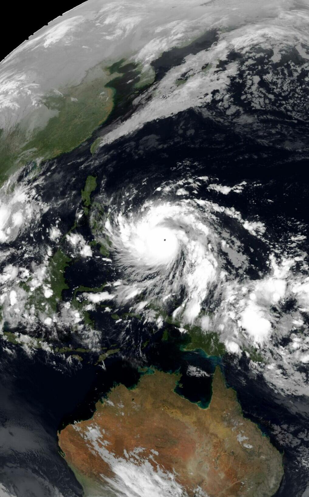
Evacuations are underway in the Philippines Islands as extremely dangerous Category 5 Super Typhoon Haiyan heads west-northwest at 20 mph towards the islands. Haiyan, which is the Chinese word for a petrel seabird, is referred to as "Yolanda" in the Philippines, and became a Category 5 storm with 160 mph winds at 12 UTC (7 am EDT) Wednesday. Haiyan became a Cat 5 at an unusually low latitude (7.9°N), but this is not a record. The most southerly Cat 5 on record was Super Typhoon Louise of 1964 (7.3°N), followed by 2012's Super Typhoon Bopha (7.4°N.) Haiyan is the fourth Category 5 storm in the Western Pacific and fifth on Earth so far in 2013. This is the highest number of Cat 5s since 2009, which had four Cat 5s in the Western Pacific and one in the Eastern Pacific. Since 2000, Earth has averaged 4.4 of these mightiest of tropical cyclones per year. The record for Cat 5s in a year is twelve, set in 1997, when an astonishing ten Cat 5s occurred in the Western Pacific. The Atlantic has not had a Category 5 storm since Hurricane Felix of 2007, making the past six years the longest stretch without a Cat 5 since 1981 - 1987.
Satellite loops show that Haiyan is a spectacular typhoon with a tiny pinhole eye just 9 miles in diameter. A buoy (station 52087) reported a pressure of 956 mb and sustained WNW winds of 67 mph at 1000 UTC (5 am EDT) Tuesday morning in the southern eyewall of Haiyan. With warm waters that extend to great depth, low wind shear, and excellent upper-level outflow, Haiyan will likely stay at Category 4 or 5 strength until landfall occurs between 03 - 06 UTC Friday in the central Philippine islands of Samar or Leyte. The only brake on Haiyan's strength over the next day might be an eyewall replacement cycle, which will be capable of causing a temporary weakening of perhaps 20 mph in the storm's winds.
Haiyan a major storm surge threat
The storm surge potential for Haiyan is very concerning, if the typhoon maintains its current forecast track and makes landfall on Leyte Island. This track would push a dangerous storm surge into the funnel-shaped Leyte Gulf, which comes to a point in Tacloban, population 221,000, the capital of the province of Leyte. Much of Tacloban is at elevations less than ten feet, and the experimental storm surge forecasts from the European Commission's Joint Research Centre HyFlux2 model made on November 5 and November 6 have called for a storm surge of 5 - 10 feet (1.6 - 2.9 meters) to hit Tacloban. This model has not been verified for the Philippines, and it is not unreasonable to speculate that the storm surge could be higher along a 20-mile swath of the coast to the north of where the eye hits, if it indeed comes ashore in Leyte. If the eye strikes farther north on Samar Island, this would not generate as high of a storm surge, since there is no triangular-shaped bay there to funnel the waters to a peak. Storm surge forecasts made by the Philippines' Project NOAH at 00 UTC November 6, 2013, are calling for no more than 2 meters (6.6 feet) of surge throughout the Philippines from Haiyan.
Haiyan the fifth named storm to hit the Philippines in 2013
Haiyan will be the fourth typhoon and fifth named storm to hit the Philippines this year. The others were:
Tropical Storm Rumbia, which hit the island of Samar on June 29 as a tropical storm, killing six.
Typhoon Nari, which hit Luzon on October 11 as a Category 3 typhoon with 115 mph winds, killing five.
Typhoon Utor, which hit Luzon on August 12 as a Category 4 typhoon with 140 mph winds, killing fourteen and causing $25 million in damage.
Typhoon Krosa, which hit northern Luzon on October 31 as a Category 2 typhoon with 105 mph winds, killing five and doing $5 million in damage.
The Philippines lie in the most tropical cyclone-prone waters on Earth, and rarely escape a year without experiencing a devastating typhoon. Usually, these storms impact the northern Philippine island of Luzon, but last year, Earth's deadliest weather disaster of 2012 occurred on the southern Philippine island of Mindanao, where Super Typhoon Bopha struck as a Category 5 super typhoon with winds of 160 mph (260 km/h), on December 3. Bopha made two additional landfalls in the Philippines, on central Visayas and on Palawan, on December 4. The typhoon left 1901 people dead, mostly on the island of Mindanao, making Bopha the 2nd deadliest typhoon in Philippine history. With damages estimated at $1.7 billion, Bopha was the costliest natural disaster in Philippines history. However, that mark was eclipsed just over four months ago, when torrential rains in the wake of Typhoon Trami inundated the capital of Manila and large areas of Luzon, killing 27 people and causing damages estimated at $2.2 billion by Aon Benfield.
Met dank aan: Weather Underground
Dat is niet niks. 
We live at a time when emotions and feelings count more than truth, and there is a vast ignorance of science. - James Lovelock


Vóór het internet dacht men dat de oorzaak van domheid een gebrek aan toegang tot informatie was. Inmiddels weten we beter.
quote:Filipijnen vreest komst tyfoon
Jan van Dam ziet bezorgd typhoon Yolanda naderen. Natuurgeweld zorgt in de Filipijnen vaak voor veel ellende.
De Filipijnen krijgt jaarlijks met het nodige natuurgeweld te maken. Naast een paar actieve vulkanen en de nodige aardbevingen razen er jaarlijks een stuk of twintig tropische depressies over de ruim 7.100 eilanden. Sommige van die depressies zijn zo hevig dat ze typhoons genoemd worden.
Op dit moment, het is vandaag 6 november als ik dit schrijf, is er een typhoon naar de Filipijnen onderweg die hier donderdagavond of vrijdagochtend aan land zal komen. Het is de vierde echt zware storm dit jaar. Met verwachte windsnelheden van 250 km of meer wordt dit wellicht de zwaarste typhoon van het jaar. De lokale naam is Yolanda, maar internationaal heet ze Haiyan.
Veel regen
Tropische depressies ontstaan als de bovenlaag van het zeewater een temperatuur heeft van 28 graden Celsius of hoger. Ze ontstaan meestal ten noorden en noordoosten van Indonesië en trekken dan westwaarts of naar het noordwesten richting de Filippijnen, Taiwan en Japan. Naast harde wind gaan ze gepaard met veel regen.
De Filipijnen wordt het vaakst getroffen door deze typhoons, elke keer weer overstromingen, landverschuivingen en andere rampen veroorzakend. Doordat het eilandenrijk veel vlakke gebieden kent tussen wat bergen en hoge heuvels, stroomt daar het regenwater naar toe.
De lage gebieden zijn van oudsher de vruchtbare gebieden waar veel rijst wordt verbouwd naast andere gewassen als maïs. Er wonen veel mensen in die gebieden, vaak langs de rivieren, riviertjes en beken. Wanneer het hard regent raken die rivieren en beken overvol, en kunnen die het aangevoerde water niet verwerken, met overstromingen als gevolg.
Delta
De hoofdstadregio, ook wel Manilla genaamd, is een gebied omsloten door heuvels en bergen en gelegen in een heuvelachtige delta. Mede als gevolg van slechte en verstopte rioleringen en zwerfvuil in de kreken en riviertjes staan na regenbuien flinke delen van deze regio onder water, soms wel twee meter hoog. Jaarlijks vallen hier slachtoffers door verdrinking en is er grote materiële schade. De lokale overheden werken vaak langs elkaar heen en verwijten elkaar hun werk niet goed te doen, maar ook de lokale bevolking werkt niet hard mee om overstromingen te voorkomen. Men blijft huisvuil in de kreken en riviertjes gooien, denkend dat het wel weg spoelt. Als we het maar kwijt zijn....
Veel afval
Je ziet dan ook dat deze waterwegen vol met afval liggen, de filters verstoppen en de gebieden onder stinkend water zettend zodra het begint te regenen. Hoewel er wetten zijn die mensen verbieden om vlak langs de waterwegen te gaan wonen, zie je overal, meest illegale bouwsels waar bij overstromingen de meeste slachtoffers vallen. Regelmatig worden deze gebieden ontruimd en opgeruimd, maar nog sneller staan ze daarna weer volgebouwd.
Dit gebeurt echter niet alleen in de regio van Manilla, maar in alle steden in de Filipijnen en het is een probleem wat niet makkelijk opgelost zal worden. Mensen zijn zich bewust van de gevaren, maar de economie van de stad lokt en ze nemen het risico om overstroomd te raken bewust. Een betere bewustwording dat afval niet op straat of in de rivier moet liggen, hoort daar ook bij. De voorlichting is er wel, maar er wordt nog te weinig gehoor aan gegeven, met name door de lager opgeleiden die in die regio's wonen.
Modderstromen
De verwachting is dat Yolanda net ten zuiden van de regio Manilla zal passeren, maar zij zal in elk geval gepaard gaan met veel regen en wind en waarschijnlijk de nodige modderstromen en/of landverschuivingen teweeg brengen. Als dat zo is zullen ook de nodige slachtoffers vallen. Hoeveel is nog af te wachten. De overheden hebben de lokale hulpdiensten in het hele land opgeroepen paraat te staan.
Vaak is het zo dat dit soort stormen licht afbuigt en een iets noordwestelijke richting volgt. Als dat het geval zal zijn wordt Manilla, met zijn 15 miljoen inwoners zwaar getroffen vrees ik. Ik kan me de supertyphoon Ondoy nog herinneren die eind september 2009 Manilla trof. Grote gebieden stonden wekenlang onder water, op sommige plaatsen meer dan drie meter hoog. Er waren toen vele honderden slachtoffers te betreuren en miljarden aan materiële schade.
De Filipijnen bidden voor en hopen op een goede afloop.
275km/u wind nu... en druk van 910 mb...
"strongest hurricane in the world for over a year" ... zie je op tweets voorbij komen
"strongest hurricane in the world for over a year" ... zie je op tweets voorbij komen
Dit ook maar eens volgen. Klinkt niet zo best allemaal en de Filipijnen zijn natuurlijk ook niet het meest bestand tegen dit soort dingen.
Baat 't niet, schaadt 't niet. Dus slikken, kreng.
De fuck, dat is gewoon een tornado van 200km doorsnede. Dat houden onze stenen huizen nog niet, laat staan wat er in de filipijnen staat.
They told me all of my cages were mental, so I got wasted like all my potential.
Da's dicht bij het record van 870..quote:Op donderdag 7 november 2013 16:48 schreef aloa het volgende:
Onvoorstelbaar lage kerndruk. Die is gezakt naar 887mb.
They told me all of my cages were mental, so I got wasted like all my potential.
Lijkt weer omhoog te gaan. Nu 888mb.quote:
[..]
Da's dicht bij het record van 870..