WKN Weer, Klimaat en Natuurrampen
Lees alles over het onstuimige weer op onze planeet, volg orkanen en tornado's, zie hoe vulkanen uitbarsten en hoe Moeder Aarde beeft bij een aardbeving. Alles over de verwoestende kracht van onze planeet en tal van andere natuurverschijnselen.


Very Intense TC GIOVANNA
Giovanna heeft de 4e categorie gehaald en heeft nu een windveld van 233 km/u, waarbij windstoten voorkomen tot 281 km/u. De orkaan koerst nu met een snelheid van 28 km/u op het eiland Madagascar af.
Volgens de verwachtingen zal de landfall plaats vinden in de provincie Toamasina.( >2.5 miljoen inwoners). GFS laat dit systeem het gehele eiland overtrekken, vervolgens zal deze weer in kracht toenemen en een tweede landfall maken in Mozambique.
Bij een orkaan van de 4e categorie hoort een stormvloed van 3,8 tot 5,5 meter boven normaal.
Plaats hier berichten over deze orkaan.
Zie ook: Hurricane Season 2012 # 1
TSR
Wunderground
Draai is duidelijk te zien bij Madagascar

Giovanna heeft de 4e categorie gehaald en heeft nu een windveld van 233 km/u, waarbij windstoten voorkomen tot 281 km/u. De orkaan koerst nu met een snelheid van 28 km/u op het eiland Madagascar af.
Volgens de verwachtingen zal de landfall plaats vinden in de provincie Toamasina.( >2.5 miljoen inwoners). GFS laat dit systeem het gehele eiland overtrekken, vervolgens zal deze weer in kracht toenemen en een tweede landfall maken in Mozambique.

Bij een orkaan van de 4e categorie hoort een stormvloed van 3,8 tot 5,5 meter boven normaal.
Plaats hier berichten over deze orkaan.
Zie ook: Hurricane Season 2012 # 1
TSR
Wunderground
Draai is duidelijk te zien bij Madagascar

Wow. En komen wij aan met ons prutswintertje van 10 dagen lang -10.
Mooie foto, met dat oog van die tornado zo
Mooie foto, met dat oog van die tornado zo
Coffee. Gets you up and moving in the mornings.

@Accuweatherquote:Cyclone Giovanna Poses Extreme Danger to Madagascar
The potentially devastating winds, rain and storm tide of Tropical Cyclone Giovanna will be brought to bear on eastern Madagascar Monday.
Life and property will be at great risk in and near the direct path of this dangerous storm, which landfall will be along the middle eastern coast of Madagascar late Monday, EST.
Monday morning, the eye of Tropical Cyclone Giovanna was located within 150 miles east-southeast of Toamasina, Madagascar, the Tropical Cyclone Center of La Reunion said. The storm was headed towards the west at nearly 15 mph.
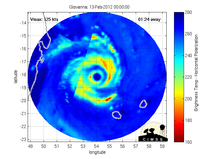
Sunday night, top winds of Giovanna was reckoned to be 125 knots, or almost 145 mph, according to the Joint Typhoon Warning Center (JTWC). Thus, Giovanna's intensity was akin to that of a Category 4 hurricane.
The JTWC forecast was for Category 4 status to be sustained as the eye of Giovanna nears landfall late Monday.
Greatest danger from potentially devastating 100-mph winds and high storm tides will be to a stretch of coast near and south of Toamasina.
Flooding rain, having potential to amount to 10 to 20 inches, will reach inland to the island nation's spine of highlands. The torrential rain could trigger landslides.
Giovanna will weaken markedly once inland, emerging by Tuesday night over the Mozambique Channel. The threat of flooding rain will follow the weakened storm right to the west coast of Madagascar.
Later in the weak, Giovanna could reach the shores of southern Mozambique as a named tropical cyclone.
Ik wil de thread niet verneuken, maar dit plaatje moet er echt even bij:

We cross our bridges when we come to them and burn them behind us, with nothing to show for our progress except a memory of the smell of smoke, and a presumption that once our eyes watered.
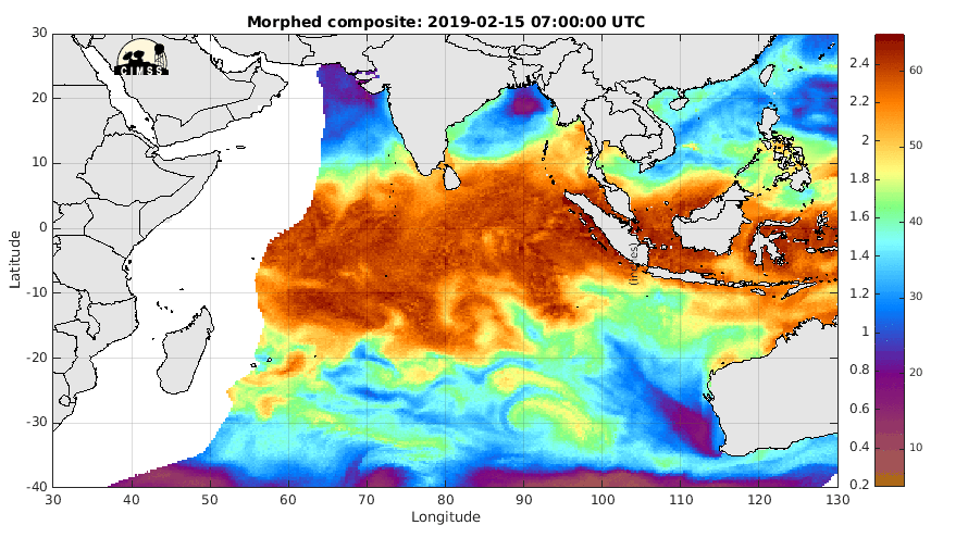
Bij Indonesie (links daarvan) ontstaat ook een nieuwe typhoon zo te zien, al zal die wel weer afzwakken voordat hij bij Madagascar aan zal komen...
Op cnn en abcnews nog niets qua berichtgeving hierover.
Coffee. Gets you up and moving in the mornings.
Wel op The Weather Channel en Accuweather. CNN zal wel een bericht plaatsen als er doden zijn gevallen.quote:Op maandag 13 februari 2012 15:06 schreef gebrokenglas het volgende:
Op cnn en abcnews nog niets qua berichtgeving hierover.


Tornado is wel heel iets anders hoorquote:Op maandag 13 februari 2012 14:57 schreef gebrokenglas het volgende:
Wow. En komen wij aan met ons prutswintertje van 10 dagen lang -10.
Mooie foto, met dat oog van die tornado zo

Een tornadokaan zou wel indrukwekkend zijn, denk je eens in wat voor een schade dat zou doen.quote:
[..]
Tornado is wel heel iets anders hoor
Zie ik het goed? Is er onder Indonesië nog een orkaan aan het ontstaan?
"Any officer who goes into action without his sword is improperly dressed." - "Mad Jack" Churchill DSO MC
quote:Earth's most dangerous storm of 2012 targets Madagascar
Earth's most dangerous storm of 2012 is Tropical Cyclone Giovanna, which is bearing down on Madagascar as a powerful Category 4 storm with 145 mph winds. Giovanna is predicted to hit a heavily populated portion of the east coast of the island near 22 GMT tonight as a Category 3 storm, then move inland, passing near the capital of Antananarivo as a Category 1 storm on Tuesday morning. The outer spiral bands of the storm have already moved over the island, bringing heavy rains and gusty winds.
The forecast: not good
Recent microwave satellite imagery shows that Giovanna has concentric eyewalls, and it likely that the inner eyewall will collapse today as the storm undergoes an eyewall replacement cycle. This process should gradually weaken the storm, and I expect Giovanna will weaken slightly to a still very dangerous Category 3 storm with 125 - 130 mph winds at landfall. However, the eyewall replacement cycle will spread out the storm's hurricane-force winds over a larger area, increasing the storm surge. A 70-mile long swath of the coast that is heavily populated will receive sustained hurricane-force winds tonight. Rainfall amounts in excess of eight inches in a 24-hour period are expected along the center of Giovanna's path. These rains will cause extensive flooding and major damage to the country, and the storm is likely to be one of the top three most expensive disasters in Malagasy history. The damage potential is higher than for previous storms of similar intensity, due to the considerable deforestation Madagascar has experienced over the past 30 years. Madagascar lost 8.3% of its forest cover between 1990 and 2010 and is now just 22% forested, according to mongabay.com. Flood waters run off quicker from deforested land, reach higher heights, and cause greater damage.
Je zou het wel denken. De krul zit er al goed in. Hij staat echter nog niet op de kaarten als "Tropische Storm", maar het kan wel binnen 24 uur komen als het zich daadwerkelijk zo ontwikkeld.quote:
Zie ik het goed? Is er onder Indonesië nog een orkaan aan het ontstaan?
[ afbeelding ]
Dan komt hij vermoedelijk eerst hier in:
Hurricane Season 2012 # 1
Ik zal eens een tweet doen richting TWU over deze krul
Hurricane Season 2012 # 1
Ik zal eens een tweet doen richting TWU over deze krul

quote:
Dan komt hij vermoedelijk eerst hier in:
Hurricane Season 2012 # 1
Ik zal eens een tweet doen richting TWU over deze krul
"Any officer who goes into action without his sword is improperly dressed." - "Mad Jack" Churchill DSO MC

quote:Madagascar has been hit by Cat.4 Giovanna
A tropical cyclone has hit the island of Madagascar, with winds of up to 194km (120mph) ripping up trees and electricity pylons.
Cyclone Giovanna made landfall overnight near the eastern port city of Toamasina.
Emergency service vehicles were out in the capital, Antananarivo, on Tuesday morning clearing up the debris.
Meteorologists warn the damage may be as bad as in 1994, when a cyclone killed 200 people and displaced 40,000.
At least one person has been killed in the inland sugar-producing town of Brickaville after an electricity pole fell on her, a government official told the Reuters news agency.
Antananarivo-based journalist Tim Healy told the BBC's Network Africa the capital is experiencing very high winds and heavy rainfall - after the eye of the storm passed through about six hours after battering Toamasina, 200km (about 125 miles) away.
People are staying at home and offices, schools and businesses have been shut.
He says he has been unable to ask residents living in and nearby Toamasina the extent of the damage there because telephone lines have been brought down by the cyclone.
But he warns it could be serious - given that many coastal villagers live in simple houses built of wood and leaves.
Town criers
The government of Madagascar issued the first warnings on Monday afternoon - but residents say the intensity of the cyclone was not explained.
Town criers, who walk around the streets ringing a bell and shouting out information in the local Malagasy language, are normally used by the government in a time of crisis.
But Mr Healy said they were not heard on Monday and it has left many people taken aback by the storm's severity.
Madagascar, the world's fourth largest island, is prone to cyclones and tropical storms, especially in the rainy season between February and May.
Mike Piggot, a meteorologist with the US-based monitoring body AccuWeather, told the BBC the storm was of a similar strength to Cyclone Geralda.
It was one of the worst cyclones to hit Madagascar and destroyed about 300,000 hectares of crops and left thousands homeless in 1994.
The storm is now heading towards southern Mozambique, he said.

De eerste mensen liggen alweer in het zwembad. Ongeveer 200 km van waar het oog van de orkaan voorbij trok.
http://nl.webcams.travel/(...)each-Ambinany-Iefaka

http://nl.webcams.travel/(...)each-Ambinany-Iefaka

Giovanna is Madagascar overgestoken en de kern ligt nu in het kanaal van Mozambique. De windsnelheid is teruggelopen naar 76 km/u met windstoten tot 92 km/u
De verwachting is dat Giovanna weer in kracht zal toenemen tot een cat 1. Welke kant de cycloon op zal gaan is afwachten..GFS laat het systeem nu weer richting Mozambique trekken. In de vorige run, liet GFS de storm weer terugkeren en langs het zuiden van Madagascar trekken.
De verwachting is dat Giovanna weer in kracht zal toenemen tot een cat 1. Welke kant de cycloon op zal gaan is afwachten..GFS laat het systeem nu weer richting Mozambique trekken. In de vorige run, liet GFS de storm weer terugkeren en langs het zuiden van Madagascar trekken.
|
|