WKN Weer, Klimaat en Natuurrampen
Lees alles over het onstuimige weer op onze planeet, volg orkanen en tornado's, zie hoe vulkanen uitbarsten en hoe Moeder Aarde beeft bij een aardbeving. Alles over de verwoestende kracht van onze planeet en tal van andere natuurverschijnselen.


El Golfo, El Hierro, De plek waar de meeste aardbevingen zijn geregistreerd
quote:Recordaantal aardbevingen op Canarisch eiland
Nog nooit eerder werden er zoveel aardbevingen achter elkaar geregistreerd op het kleine vulkanische eilandje El Hierro, het kleinste van de Canarische Eilanden. De reeks van maar liefst 720 bevinkjes heeft de overheid van deze eilandengroep voor de kust van West Afrika ertoe doen besluiten om voor het eerst in de geschiedenis een vergadering bijeen te roepen van het Stuurcomité van Vulkanische Monitoring. Dit comité werd opgericht om specifieke plannen te realiseren, die de burgerbevolking dienen te beschermen en noodplannen voor vulkanische risico’s moeten ontwikkelen. Inmiddels wordt gesproken over een ‘significante dreiging van seismische activiteit’.
Het Nationaal Geografisch Instituut (IGN) en het Volcanologische Instituut van de Canarische eilanden blijft nauwlettend de aardbevingen in de gaten houden, waarvan de kracht van de bevingen (elke dag!) ligt tussen de 1 en 3 op de Richterschaal. De meerderheid van de bevingen vindt plaats tussen 5 en 15 km diepte.
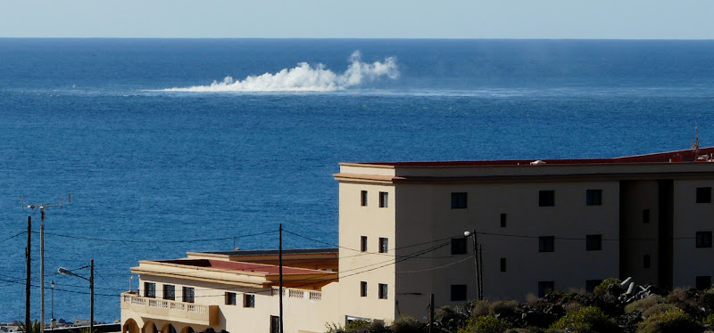
Volgens de autoriteiten betekent deze seismische activiteit nog niet direct dat een grotere, significante aardbeving zal plaatsvinden. Het merendeel van de bevingen die zijn geregistreerd, vonden plaats in het Noord Westen van het 280 vierkante kilometer kleine eilandje, bij het plaatsje El Golfo (zie foto hieronder). Een aardbeving op deze plaats zorgde er zo’n 50.000 jaar geleden voor, dat er een enorme landverschuiving plaatsvond, waarbij de helft van de vulkaan in zee gleed. Hierdoor ontstond een ca. 100 meter hoge tsunami die naar de overzijde van de Atlantische oceaan zou zijn gegleden. Schuin tegenover dit eilandje, in het verlengde van de resterende halve kratermond, ligt het Noord Amerikaanse continent..
quote:El Hierro Earthquake Swarm Enters Third Week
The intensity of earthquakes recorded on the smallest of the Canary Islands, El Hierro, has increased slightly during the last 24 hours. However, the total number of earthquakes recorded daily has lessened since the earthquake swarm initially began on 17 July.
The total number of tremors recorded during the past two weeks has now exceeded 1,050, according to the Instituto Geografico Nacional (IGN).
The majority of the earth tremors ranged between 1-2 magnitude, but during the past 24 hours there have been least five tremors measuring in excess of 2.0 magnitude on the Richter Scale. A 2.4 magnitude earthquake was recorded at 4:56 p.m. local time on Sunday (31 July 2011).
Approximately 50 earth tremors were recorded on Sunday, according to local earthquake monitoring agency Actualidad Volcánica de Canarias (AVCAN). The number is slightly down on the number of tremors recorded on Saturday and significantly less than the 195 earthquakes recorded on 22 July.
quote:The vast majority of the tremors have been recorded in the northwest of the 278.5-square-kilometre island at El Golfo, the location of a massive landslide that created a 100-metre high tsunami almost 50,000 years ago.
The earthquake swarm, prompted the Canary Islands Government to convene the first ever meeting on 22 July of the Steering Committee and Volcanic Monitoring, reflected in the Specific Plan Protection Civil and Emergency for Volcanic Risk, given what it described “the significant increase in seismic activity”. The Committee met again on Friday 29 July to discuss the low magnitude seismic activity. It reported that it had stepped up its seismic monitoring operations to identify the source of the earthquakes.
Following an evaluation of seismic and volcanological information gathered by the IGN and volcanological Institute of the Canary Islands, the Committee agreed to activate “monitoring and surveillance mechanisms necessary to coordinate the actions of civilian self-protection and information to people listed in the Plan” (translated from Spanish press release). It remains unclear, however, if the unprecedented seismic activitiy on El Hierro is a precursor to a possible future increase in earthquake or volcanic activity.
Earthquake swarms are events where a local area experiences sequences of many earthquakes striking in a relatively short period of time. The length of time used to define the swarm itself varies, but the United States Geological Survey (USGS) points out that an event may last for days, weeks, or months.
El Hierro’s Volcanic/Seismic Past
El Hierro is situated in the most southwestern extreme of the Canaries. The island was formed after three successive eruptions, and consequent accumulations, the island emerged from the ocean as an imposing triangular pyramid crowned by a volcano more than 2,000 metres high.
The volcanic activity, principally at the convergence of the three ridges, resulted in the continual expansion of the island. A mere 50,000 years ago, as a result of seismic tremors which produced massive landslides, a giant piece of the island cracked off, crashed down into the ocean and scattered along the seabed. This landslide of more than 300km3 gave rise to the impressive amphitheatre of the El Golfo valley and at the same time caused a tsunami that most likely rose over 100 metres high and probably reached as far as the American coast.


Links
Live webcams op het eiland El Hierro
Zelfde webcams via andere link
Actuele seismische activiteit
AVCan - vulcanologiesch instituut Canarische eilanden
Spaans geografisch instituut
INVOLCAN Facebook pagina
AVCAN facebook pagina
Canariesnews
Tumbit
en op twitter kun je zoeken op #hierro, #elhierro of #viveelhierro
@noticiacanaria Wel veel ander nieuws
@canariesnews
@eruptionsblog
@teideano 1 van de onderzoekers op El Hierro
Gerelateerde topics
[Vulkanen] The ring of fire #6: Waar diverse vulkanen puffen
Aardbevingen #13
Mega tsunami door in zee vallen van eiland La Palma?
<a href="http://goo.gl/q8fhTe" target="_blank">FAQ?</a>
<a href="http://goo.gl/gYvZFq" target="_blank">Geel is een zonnige en vrolijke kleur, als hij tenminste enigszins warm is gekleurd en wat naar het oranje neigt</a>
<a href="http://goo.gl/gYvZFq" target="_blank">Geel is een zonnige en vrolijke kleur, als hij tenminste enigszins warm is gekleurd en wat naar het oranje neigt</a>
Tremors weten niet wat ze willen.
Maar mijn vermoeden is ook wel een beetje dat de schaal is aangepast door de IGN.
Maar mijn vermoeden is ook wel een beetje dat de schaal is aangepast door de IGN.

<a href="http://goo.gl/q8fhTe" target="_blank">FAQ?</a>
<a href="http://goo.gl/gYvZFq" target="_blank">Geel is een zonnige en vrolijke kleur, als hij tenminste enigszins warm is gekleurd en wat naar het oranje neigt</a>
<a href="http://goo.gl/gYvZFq" target="_blank">Geel is een zonnige en vrolijke kleur, als hij tenminste enigszins warm is gekleurd en wat naar het oranje neigt</a>
Dat wat ik eerder had geroepen wordt nu ook bevestigd.
de maanstand - en dus de getijden - is van invloed op de pieken en dalen van ongeveer 12 uur.
[ Bericht 23% gewijzigd door bwt op 23-01-2012 20:55:20 ]
de maanstand - en dus de getijden - is van invloed op de pieken en dalen van ongeveer 12 uur.
quote:NOTE AVCAN 427 - EARTHQUAKE ACTIVITY-VOLCANIC - HIERRO ISLAND - 22 January 2012-12:30 h peninsular - seismic-volcanic activity remains moderate, one in the mountain area east of Tanganasoga, two in the Julan and one in the Llanillos , also with some of seismicity detected but not localized.
Continued volcanic tremor signal in the eruption of the Restinga, and seems to follow cycles d ... and a 12-18h, coinciding with high tides and low tides so that when the tide up and down, having a variation in the water pressure, water enters the tube and becomes very unstable, with loud explosions hydromagmatic, making mincemeat ejecta and more stable at low tide where they exit from lava or pyroclastic balloons floating to the surface smoldering. On day 20 the highest tremor coincided with low tides, the 21 (day before yesterday), and change Yesterday's tremor Igua that coincided with high tides roughly, today has once again changed and coincided with low tide follows high tremor would be for the next low tide at 19:00 h. .. can not not be as simple
The magnitude of the earthquakes located between 1.6 and 0.3. New quakes 6. Profundidada 12, 13, 14, 15, 15 and 16km. Before yesterday 5. Yesterday 4. Today van 2. A total of 12,022 earthquakes are located in El Hierro by IGN from 9:00 am of July 19, 2011 (Enrique).
-------------------
The seismicity map of the last two weeks you can see the circular zone of seismicity of the past days with the strongest earthquakes in the peripheral zone. The two quakes today (Rosa) are ranked according to the prolongation of the NE-SW axis of the island in the Cala Tacorón and the Sea of las Calmas, prolongation active these last days as shown in the earthquakes of days before. Yesterday was the seismic shift in the west of Tanganasoga and Sabina, with 2 peaks in the area, 1 on the coast and another in the Gulf escarpment to the west.
Also be seen as 3 concentric arcs that begin in NS Direction to go turning to NNW-SSE to NW-SE, WNW-ESE and end EO curious and whose interpretation could be a dispersion of efforts by a feather mantle provocandos below the bark ... if so, your focus or center points to the border area to the point where deep seismicity has been detected the past 01 days, almost nothing (Enrique).
DAY 23 JAN EARTHQUAKES. - Rosa (2)
DAY 22 JAN EARTHQUAKES. - Blue (4)
EARTHQUAKES OF THE DAY 06 to 21 JAN. - Yellow (34)
New earthquakes detected and located yesterday and today by the IGN in the area of the island of El Hierro and vicinity since the last note AVCAN:
1119745 01/01/2012 12:17:54 27.7456 -17.9893 34 1.8 4 SE FRONTERA.IHI
1122704 22/01/2012 20:21:14 27.7139 -18.0735 12 0.3 4 SW FRONTERA.IHI
1122703 22/0 ...1/2012 20:35:32 27.7400 -18.1023 16 0.3 4 W FRONTERA.IHI
1122706 22/01/2012 21:21:45 27.7477 -18.0716 15 1.0 4 W FRONTERA.IHI
1122729 22/01/2012 22:14:19 27.7112 -18.0713 13 0.8 4 SW FRONTERA.IHI 12022
1120938 11/01/2012 03:07:01 27.7491 -18.0899 29 II 2.4 4 W FRONTERA.IHI
1122739 23/01/2012 05:39:21 27.6886 -18.0303 15 1.1 4 SW EL PINAR.IHI
1122740 23/01/2012 07:19:12 27.6570 -18.0587 14 1.6 4 SW EL PINAR.IHI
1122793 23/01/2012 11:12:17 27.7095 -18.0403 16 1.4 4 W EL PINAR.IHI

quote:Update 23/01 -11:57 UTC
As we see a more and more active jacuzzi area, we can start thinking of the new phase soon, the Surtseyan phase (when, is depending on the vent activity and can be from hours to weeks if the eruption continues like it goes now).
We want to stress however that based on the just happened Red Sea eruption, the distance from the vent to the coast would be safe enough to not damage La Restinga or any other part of the island. A Surtseyan phase will go normally gradually and with all the scientists aboard, people will have no risk at all.
Additionally IGN or INVOLCAN / ITER have not yet measured high concentrations of the typical eruption gases as yet) It would not surprise us to see it happening soon as the vent depth is reaching the point where the superheated steam pressure from below (magma (1100°C) /water interaction) can become bigger than the water column above it.
We have written it before, but it maybe good the repeat the Wikipedia description of the Surtseyan eruption : A Surtseyan eruption (or hydrovolcanic) is a type of volcanic eruption caused by shallow-water interactions between water and lava, named so after its most famous example, the eruption and formation of the island of Surtsey off the coast of Iceland in 1963. Surtseyan eruptions are the wet equivalent of ground-based Strombolian eruptions, but because of where they are taking place, they are more explosive (ER read : steam and ash columns). This is because as water is heated by lava, it flashes in steam and expands violently, fragmenting the magma it is in contact with into fine-grained ash.
- Joke has just reported (you may have seen it on the webcam) that the Guardia Civil /Involcan helicopter was hanging close to the vent measuring gases and temperatures.

[ Bericht 23% gewijzigd door bwt op 23-01-2012 20:55:20 ]
<a href="http://goo.gl/q8fhTe" target="_blank">FAQ?</a>
<a href="http://goo.gl/gYvZFq" target="_blank">Geel is een zonnige en vrolijke kleur, als hij tenminste enigszins warm is gekleurd en wat naar het oranje neigt</a>
<a href="http://goo.gl/gYvZFq" target="_blank">Geel is een zonnige en vrolijke kleur, als hij tenminste enigszins warm is gekleurd en wat naar het oranje neigt</a>
Video's van gister:
[ Bericht 9% gewijzigd door bwt op 24-01-2012 09:09:46 ]


En de tremors blijven in golven met het getijde komenquote:Update 23/01 – 23:58 UTC
The video above made by the Involcan / Guardia Civil has been recorded this morning while the jacuzzi was still very strong. It shows 2 different vents separate from each other, a new phenomenon as far as the last couple of days and weeks.
Update 23/01 – 23:55 UTC
- An 8th earthquake happened at 23:05. The earthquake had a magnitude of 1.1 (depth unknown at the moment). Epicenter here
- Harmonic tremor minimal but surviving. Very hard to say what will happen next.
Update 23/01 – 22:55 UTC
- Harmonic tremor came again to life at 20:43 UTC and is still surviving a little bit at the time of writing this update. Just as this morning we see regular strong hydromagmatic bursts.
- 3 more earthquakes later today , making it a total of 7 earthquakes today !
23/01/2012 15:12:28 27.7501 -18.0543 13 1.3 4 W FRONTERA.IHI
23/01/2012 15:44:08 27.7565 -18.0286 5 0.6 4 W FRONTERA.IHI
23/01/2012 20:20:35 27.6701 -18.0068 26 1.4 4 SW EL PINAR.IHI

quote:DAY 23 JAN EARTHQUAKES. - Pink (6)
DAY 22 JAN EARTHQUAKES. - Blue (4)
EARTHQUAKES OF THE DAY 06 to 21 JAN. - Yellow (34)
Earthquakes Today, three new, noteworthy that near Frontera, rose above the right of 0.6 to 5.1 km and the two alignments NE-SW and NNW-SSE ...
1122739 23/01/2012 05:39:21 27.6886 -18.0303 15 1.1 mbLg SW EL PINAR.IHI - El Hierro
1122740 23/01/2012 07:19:12 27.6570 -18.0587 14.2 1.6 mbLg SW EL PINAR.IHI - El Hierro
1122793 23/01/2012 11:12:17 27.7095 -18.0403 15.5 1.4 mbLg W EL PINAR.IHI - El Hierro
1122839 23/01/2012 12:21:17 27.6650 -18.0512 11.8 1.5 mbLg SW EL PINAR.IHI - El Hierro
1122875 23/01/2012 15:12:28 27.7501 -18.0543 12.7 1.3 mbLg W FRONTERA.IHI - El Hierro
1122878 23/01/2012 15:44:08 27.7565 -18.0286 5.1 0.6 mbLg W FRONTERA.IHI - El Hierro

[ Bericht 9% gewijzigd door bwt op 24-01-2012 09:09:46 ]
<a href="http://goo.gl/q8fhTe" target="_blank">FAQ?</a>
<a href="http://goo.gl/gYvZFq" target="_blank">Geel is een zonnige en vrolijke kleur, als hij tenminste enigszins warm is gekleurd en wat naar het oranje neigt</a>
<a href="http://goo.gl/gYvZFq" target="_blank">Geel is een zonnige en vrolijke kleur, als hij tenminste enigszins warm is gekleurd en wat naar het oranje neigt</a>
De tremors zijn weer aanwezig - de baloons zullen weer minder worden
quote:NOTE AVCAN 428 - EARTHQUAKE ACTIVITY-VOLCANIC - HIERRO ISLAND - 24 January 2012-12:00 h peninsular - seismic-volcanic activity remains moderate earthquakes located over having no sign of tremor, with today's summit area Tanganasoga east of, and yesterday in a NS strip through the same area, with some seismicity detected but not localized. Continued volcanic tremor signal in the eruption of the Restinga, alternating tremor peridos with low and quiet with periods where it is very unstable, with loud explosions hydromagmatic and ups and downs, went up yesterday and this morning has stopped and has been in the last hours minimum. Magnitude between 1.5 and 0.3. New earthquakes 10. Profundidada 12 and 13km (5.1km and one and two at 15.5 and 25.8km). The day before yesterday 4. Yesterday 8. Today van 4. A total of 12,032 earthquakes are located in El Hierro by IGN from 9:00 am of July 19, 2011 (Enrique)
<a href="http://goo.gl/q8fhTe" target="_blank">FAQ?</a>
<a href="http://goo.gl/gYvZFq" target="_blank">Geel is een zonnige en vrolijke kleur, als hij tenminste enigszins warm is gekleurd en wat naar het oranje neigt</a>
<a href="http://goo.gl/gYvZFq" target="_blank">Geel is een zonnige en vrolijke kleur, als hij tenminste enigszins warm is gekleurd en wat naar het oranje neigt</a>
If true, interestingquote:Pam Thornton says:
January 24, 2012 at 11:26 am
Yes indeed I’m glued. I think my theory of seagulls preceding the sls is bang on! Sorry if that sounds smug, but it’s true.
De minimum tremors zijn weer goed zichtbaar.
Gister was het weer wat zwaarder dan de dagen er voor.
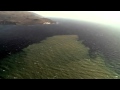
Er is trouwens wel een mooie vlek op de webcam te zien
Goed van kleur ook
[ Bericht 22% gewijzigd door bwt op 25-01-2012 12:01:37 ]
Gister was het weer wat zwaarder dan de dagen er voor.

En nog wat video's van de 23equote:NOTE AVCAN 429 - EARTHQUAKE ACTIVITY-VOLCANIC - HIERRO ISLAND - 25 January 2012-11:45 h peninsular - seismic-volcanic activity remains moderate earthquakes located over having no sign of tremor, today one in the Cala Tacorón and two more in the mountain area south of Tanganasoga, and yesterday the same area, further east in the interior of the island continues volcanic tremor signal in the eruption of the Restinga is declining but remains alternating peridos with low and quiet tremor with periods where it is more unstable, with loud explosions hydromagmatic and ups and downs, went up yesterday and this morning has rebounded somewhat the down after 5:55 pm. Magnitude between 1.6 and 0.5. New earthquakes 5. Profundidada 12 and 13km. Before yesterday 8. Yesterday 6. Now go 3. A total of 12,037 earthquakes are located in El Hierro by IGN from 9:00 am of July 19, 2011 (Enrique).
DAY 25 JAN EARTHQUAKES. - Green (3)
DAY 24 JAN EARTHQUAKES. - Green (6)
DAY 23 JAN EARTHQUAKES. - Pink (8)
DAY 22 JAN EARTHQUAKES. - Blue (4)
EARTHQUAKES OF THE DAY 06 to 21 JAN. - Yellow (34)
The seismicity map of the last two weeks you can see the circular zone of seismicity of the past days with the strongest earthquakes in the peripheral zone. Earthquakes today (red) with an area of Cala Tacorón and two more in the mountain area south of Tanganasoga, and yesterday (green) night the same area, further east in the interior of the island, area east of Tanganasoga peaks, all within the island. The day before yesterday earthquakes (Rosa) NS line and according to the prolongation of the NE-SW axis of the island in the Cala Tacorón and the Sea of Calm, and active in recent days prolongation NNW-SSE as can earthquakes seen in the previous days.
detected and located yesterday and today by the IGN in the area of the island of El Hierro and vicinity since the last note AVCAN:
1123227 24/01/2012 20:29:26 27.6866 -18.0398 13.5 1.6 mbLg SW EL PINAR.IHI
1123251 24/01/2012 23:28:05 27.6799 -18.0390 12.8 1.2 mbLg SW EL PINAR.IHI
1123295 25/01/2012 04:08:11 27.6980 -18.0631 12.0 1.1 mbLg W EL PINAR.IHI
1123296 25/01/2012 04:09:48 27.7104 -18.0627 13.4 0.9 mbLg SW FRONTERA.IHI
1123344 25/01/2012 05:00:40 27.6638 -18.0352 13.2 0.5 mbLg SW EL PINAR.IHI


Er is trouwens wel een mooie vlek op de webcam te zien
Goed van kleur ook
[ Bericht 22% gewijzigd door bwt op 25-01-2012 12:01:37 ]
<a href="http://goo.gl/q8fhTe" target="_blank">FAQ?</a>
<a href="http://goo.gl/gYvZFq" target="_blank">Geel is een zonnige en vrolijke kleur, als hij tenminste enigszins warm is gekleurd en wat naar het oranje neigt</a>
<a href="http://goo.gl/gYvZFq" target="_blank">Geel is een zonnige en vrolijke kleur, als hij tenminste enigszins warm is gekleurd en wat naar het oranje neigt</a>
quote:Update 25/01 – 10:51 UTC
- a bit late today for our first reporting due to an earthquake close to Parma in Northern Italy
- jacuzzi waters strong and a minor harmonic tremor. As we have seen many times before, there seems to be NO direct relation in between HT and the activity at the surface during the normal ongoing submarine eruption. Only the violent phase during the beginning of November was an exception on this.
- have you seen the VERY BIG magma stone in the jacuzzi waters. This block must be meters wide !, almost like a rocK We know the proportion since the blocks we saw a few weeks ago looked minor on the webcam and and where 1.5 meter tall !
- 3 earthquakes so far today. The earthquakes are showing the continuous pressure of the magma against the volcano cone of El Hierro. The magma seeks openings everywhere and is pressing against crevasses, lava tubes etc.
Update 25/01 13:14 UTC
- Ann-Kristin made the remarkable webcam capture : A men/woman walking on the jacuzzi !

1123472 25/01/2012 13:00:54 27.6629 -18.0044 13 1.6 4 SW EL PINAR.IHI

Webcam beelden van vandaag


[ Bericht 11% gewijzigd door bwt op 25-01-2012 17:15:39 ]
<a href="http://goo.gl/q8fhTe" target="_blank">FAQ?</a>
<a href="http://goo.gl/gYvZFq" target="_blank">Geel is een zonnige en vrolijke kleur, als hij tenminste enigszins warm is gekleurd en wat naar het oranje neigt</a>
<a href="http://goo.gl/gYvZFq" target="_blank">Geel is een zonnige en vrolijke kleur, als hij tenminste enigszins warm is gekleurd en wat naar het oranje neigt</a>
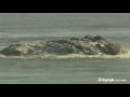
Je ziet de stoom er af komen..
is dat water nou zo heet of komt t bijna aan de oppervlakte?
is dat water nou zo heet of komt t bijna aan de oppervlakte?
| Wordfeud: marcel-o |plug.dj/uptempo |<-- draai zelf je platen
Het water is (althans een aantal dagen geleden) nauwelijks warmer op de plek waar het wit is. Dat zijn voornamelijk gasbubbels die opstijgen. Soms raken die gasbubbels gevangen in de lava, en in een zeldzaam geval ontstaan er zo hete brokken, gevuld met gas, die naar de oppervlakte stijgen. Die veroorzaken de rookpluimen die je soms ziet. Als er hele rookwolken ontstaan, net zoals gister het geval was, dan zijn dat heel veel van die brokken.quote:Op woensdag 25 januari 2012 18:21 schreef marcel-o het volgende:
Je ziet de stoom er af komen..
is dat water nou zo heet of komt t bijna aan de oppervlakte?
Hier een illustratie wat er gebeurt, En als je goed oplet tijdens de activiteit, zie je ook dat die brokken/de rook zich niet in de 'jacuzzi' bevinden, maar er net achter

Kuch, er lijkt nu wel wat meer aan de hand te zijn. Op de Ustream webcam is te zien dat er zich aan de oppervlakte kleine 'explosies' plaats vinden. Ik denk niet dat het 'koken' is, maar wat het wél is? Die lava balloons kunnen voor zover ik weet in een enkel geval ook exploderen, maar nu zouden ze dat ineens allemaal doen. Misschien door een groter temperatuurverschil omdat de vulkaan toch echt dichtbij begint te komen?
Edit: Het kan ook de reflectie zijn van de zon, maar dat toont weer dat het water toch wel flink onrustig is.
[ Bericht 12% gewijzigd door Tokamak op 25-01-2012 19:12:46 ]
Edit: Het kan ook de reflectie zijn van de zon, maar dat toont weer dat het water toch wel flink onrustig is.
[ Bericht 12% gewijzigd door Tokamak op 25-01-2012 19:12:46 ]
Beving van 2.5 gevolgd door een van 1.8
1123504 25/01/2012 17:01:35 27.6401 -18.0339 14 2.5 4 SW EL PINAR.IHI
1123505 25/01/2012 17:06:01 27.6280 -18.0333 14 1.8 4 SW EL PINAR.IHI
Was erg goed zichtbaar bij de tremors.
En weer Bingo
Voelbaar deze keer
1123512 25/01/2012 20:22:34 27.6722 -18.0295 12 Sentido 2.8 4 SW EL PINAR.IHI
[ Bericht 12% gewijzigd door bwt op 25-01-2012 23:28:49 ]
1123504 25/01/2012 17:01:35 27.6401 -18.0339 14 2.5 4 SW EL PINAR.IHI

1123505 25/01/2012 17:06:01 27.6280 -18.0333 14 1.8 4 SW EL PINAR.IHI

Was erg goed zichtbaar bij de tremors.

En weer Bingo
Voelbaar deze keer
1123512 25/01/2012 20:22:34 27.6722 -18.0295 12 Sentido 2.8 4 SW EL PINAR.IHI


[ Bericht 12% gewijzigd door bwt op 25-01-2012 23:28:49 ]
<a href="http://goo.gl/q8fhTe" target="_blank">FAQ?</a>
<a href="http://goo.gl/gYvZFq" target="_blank">Geel is een zonnige en vrolijke kleur, als hij tenminste enigszins warm is gekleurd en wat naar het oranje neigt</a>
<a href="http://goo.gl/gYvZFq" target="_blank">Geel is een zonnige en vrolijke kleur, als hij tenminste enigszins warm is gekleurd en wat naar het oranje neigt</a>
En de tremors voor vandaag:
[ Bericht 40% gewijzigd door bwt op 26-01-2012 11:00:33 ]

quote:NOTE AVCAN 430 - EARTHQUAKE ACTIVITY-VOLCANIC - HIERRO ISLAND - 26 January 2012-10:45 h peninsular - seismic-volcanic activity remains moderate to high, with more earthquakes located to be any sign of tremor in the Sea of las Calmas, Cala area Tacorón and southeast of the island quite microseismicity also detected but not localized tonight, after the earthquake of 2.8 aparecenal least two long-period events or LP, indicating depressurization of fluids and magma movement and is clearly seen in the figure of the spectrogram.
Continued volcanic tremor signal in the eruption of the Restinga, and even decreases while still alternating periods with low and quiet tremor with periods where it is more unstable, with loud explosions and many ups and downs hydromagmatic yesterday morning and went up to continued until 16:40 h and this morning has rebounded somewhat the down after 5:20 pm.
Magnitude between 2.8 and 1.0. New quakes 7. 2 felt earthquakes with intensity II. Depth between 12 and 13km. Before yesterday 6. Yesterday 8. Today van 2. A total of 12,044 earthquakes are located in El Hierro by IGN from 9:00 am of July 19, 2011 (Enrique).
New earthquakes detected and located yesterday and today by the IGN in the area of the island of El Hierro and vicinity since the last note AVCAN:
1123472 25/01/2012 13:00:54 27.6629 -18.0044 12.8 1.6 4 SW EL PINAR.IHI
1123504 25/01/2012 17:01:35 27.6401 -18.0339 13.5 II 2.5 4 SW EL PINAR.IHI
1123505 25/01/2012 17:06:01 27.6280 -18.0333 13.9 1.8 4 SW EL PINAR.IHI 12040
1123513 25/01/2012 19:19:10 27.6908 -18.0345 12.3 1.2 4 SW EL PINAR.IHI
1123512 25/01/2012 20:22:34 27.6722 -18.0295 12.4 II 2.8 4 SW EL PINAR.IHI
1123531 26/01/2012 01:53:50 27.6990 -18.0276 13 1.0 4 W EL PINAR.IHI
1123586 26/01/2012 07:18:45 27.6650 -18.0308 12 1.0 4 SW EL PINAR.IHI

[ Bericht 40% gewijzigd door bwt op 26-01-2012 11:00:33 ]
<a href="http://goo.gl/q8fhTe" target="_blank">FAQ?</a>
<a href="http://goo.gl/gYvZFq" target="_blank">Geel is een zonnige en vrolijke kleur, als hij tenminste enigszins warm is gekleurd en wat naar het oranje neigt</a>
<a href="http://goo.gl/gYvZFq" target="_blank">Geel is een zonnige en vrolijke kleur, als hij tenminste enigszins warm is gekleurd en wat naar het oranje neigt</a>
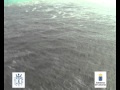
Tremors zijn laag en af en toe aanwezig. De activiteit lijkt echt af te nemen.
OF de vent zit goed dicht (dat zou de bevingen mogelijk kunnen veroorzaken)
En het is best rustig op de webcam.
[ Bericht 20% gewijzigd door bwt op 27-01-2012 12:17:22 ]
OF de vent zit goed dicht (dat zou de bevingen mogelijk kunnen veroorzaken)

1123727 27/01/2012 04:24:53 27.6967 -18.0378 13 2.0 4 W EL PINAR.IHIquote:AVCAN
A deep earthquake of 1.9 at 19:49 at 23km in the Gulf, then we have an LP at 17:49, another 1.0 to 16km sismito in Pinar and then two, curiously have been becoming more shallow, and some but not finally located and tremor resurrects and comes back at about 19:46 that evening we are completita ... I leave the map of the earthquakes that we have today (Enrique).
1123677 26/01/2012 16:49:12 27.7512 -18.0694 23.3 1.9 W FRONTERA.IHI mbLg
1123678 26/01/2012 17:56:05 27.7074 -18.0472 15.6 1 mbLg W THE PINAR.IHI
1123684 26/01/2012 19:02:45 27.6674 -18.0590 14.5 1.5 SW mbLg PINAR.IHI
1123685 26/01/2012 19:19:57 27.7050 -18.0686 14.2 0.6 W THE PINAR.IHI mbLg
DAY 26 JAN EARTHQUAKES. - Dark Blue (6)
EARTHQUAKES OF THE DAY JAN 23 to 25. - Yellow (22)


En het is best rustig op de webcam.

quote:NOTE AVCAN 431 - EARTHQUAKE ACTIVITY-VOLCANIC - HIERRO ISLAND - 27 January 2012-10:00 h peninsular - seismic-volcanic activity continues to moderate, with more earthquakes located microseismicity and having no sign of tremor, located from the coast and border peaks in the area of Cala Tacorón through the Julan and one in the Sea of las Calmas. Also tonight quite microseismicity detected but not localized. Continued volcanic tremor signal in the eruption of the Restinga, and even decreases while still alternating periods with low and quiet tremor with periods where it is more unstable, with loud explosions and many ups and downs hydromagmatic yesterday afternoon by La rose from 19:49 h o'clock and this morning has stopped. Magnitude between 2.0 and 0.4. New earthquakes 12. Depth between 10.5 and 15.6km (and another one at 9.5 and 23.3km). Before yesterday 8. Yesterday 6. Now go 8. A total of 12,056 earthquakes are located in El Hierro by IGN from 9:00 am of July 19, 2011 (Enrique).
DAY 27 JAN EARTHQUAKES. - Red (8)
DAY 26 JAN EARTHQUAKES. - Dark Blue (6)
EARTHQUAKES OF THE DAY JAN 23 to 25. - Yellow (22)
Today Earthquakes accumulate in Julan area and two Border and coincides with one of yesterday along the coast. You will see a series of alignments CalaTacorón EO against entering land and other axis NS and NNW-SSE.
1123677 26/01/2012 16:49:12 27.7512 -18.0694 23.3 1.9 mbLg W FRONTERA.IHI
1123678 26/01/2012 17:56:05 27.7074 -18.0472 15.6 1.0 mbLg W EL PINAR.IHI
1123684 26/01/2012 19:02:45 27.6674 -18.0590 14.5 1.5 mbLg SW EL PINAR.IHI
1123685 26/01/2012 19:19:57 27.7050 -18.0686 14.2 0.6 mbLg W EL PINAR.IHI
1123698 27/01/2012 01:02:27 27.6664 -18.0195 11.7 0.9 mbLg SW EL PINAR.IHI
1123723 27/01/2012 02:13:41 27.6889 -18.0475 12.9 0.9 mbLg SW EL PINAR.IHI 12050
1123727 27/01/2012 04:24:53 27.6967 -18.0378 12.8 2.0 mbLg W EL PINAR.IHI
1123729 27/01/2012 06:27:16 27.6936 -18.0435 10.5 0.4 mbLg W EL PINAR.IHI
1123730 27/01/2012 06:27:45 27.7065 -18.0425 11.2 0.4 mbLg W EL PINAR.IHI
1123732 27/01/2012 06:57:15 27.7537 -18.0703 14.6 0.7 mbLg W FRONTERA.IHI
1123733 27/01/2012 07:39:10 27.6662 -18.0715 9.5 0.4 mbLg SW EL PINAR.IHI
1123735 27/01/2012 07:55:53 27.7478 -18.0693 15.5 0.5 mbLg W FRONTERA.IHI

[ Bericht 20% gewijzigd door bwt op 27-01-2012 12:17:22 ]
<a href="http://goo.gl/q8fhTe" target="_blank">FAQ?</a>
<a href="http://goo.gl/gYvZFq" target="_blank">Geel is een zonnige en vrolijke kleur, als hij tenminste enigszins warm is gekleurd en wat naar het oranje neigt</a>
<a href="http://goo.gl/gYvZFq" target="_blank">Geel is een zonnige en vrolijke kleur, als hij tenminste enigszins warm is gekleurd en wat naar het oranje neigt</a>
Dit lijkt er sterk op dat de boel weer gaat open barsten.
Volgens mij hebben we dit patroon al een paar keer eerder gezien.
Maar het lijkt er inderdaad op dat de "vent" goed dicht zit.
We wachten af....
Volgens mij hebben we dit patroon al een paar keer eerder gezien.
Maar het lijkt er inderdaad op dat de "vent" goed dicht zit.
We wachten af....
Hoewel het rustig is blijven de tremors met de getijden sterker en zwakker worden.

quote:[bron] 19:00 uur
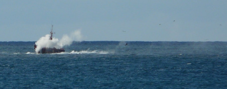
Today we are going and for the 12 earthquakes, 4 more than the last part .. a sismito to 10.5 under Frontera and the truth is that earthquakes are making the area very well magma conduit through the fault, fissure or dike from the el Golfo area, passing under the Tangansoga (an earthquake at 10.5km ) NNW-SSE direction towards SSE passes the mountain area (an earthquake there at 19km), the Julan and will end in the eruption of the Restinga, which returns to bubbling and activity since the tremor was resumed last two in the afternoon ... and for dessert the ship Salvamar by bubbling area a few minutes ago. (Enrique).
DAY 27 JAN EARTHQUAKES. - Red (12)
DAY 26 JAN EARTHQUAKES. - Dark Blue (6)
EARTHQUAKES OF THE DAY JAN 23 to 25. - Yellow (22)
1123739 27/01/2012 09:18:10 27.6995 -18.0699 11.8 0.9 mbLg W EL PINAR.IHI - El Hierro
1123834 27/01/2012 14:14:06 27.7629 -18.0267 10.5 1.1 mbLg W FRONTERA.IHI - El Hierro
1123836 27/01/2012 15:16:34 27.7155 -18.0528 19 0.9 mbLg SW FRONTERA.IHI - El Hierro
1123843 27/01/2012 16:41:33 27.7326 -18.0573 14.8 0.5 mbLg SW FRONTERA.IHI - El Hierro

<a href="http://goo.gl/q8fhTe" target="_blank">FAQ?</a>
<a href="http://goo.gl/gYvZFq" target="_blank">Geel is een zonnige en vrolijke kleur, als hij tenminste enigszins warm is gekleurd en wat naar het oranje neigt</a>
<a href="http://goo.gl/gYvZFq" target="_blank">Geel is een zonnige en vrolijke kleur, als hij tenminste enigszins warm is gekleurd en wat naar het oranje neigt</a>
Tremors zijn laag/niet sterk maar wel aanwezig.
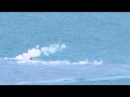
En weer een mooie timelapse
Gister voldoende activiteit geweest. Vele Smoking Lava Stones (SLS)
Deze heeft een gat waardoor het hete gas is ontsnapt (de veroorzaker van de grote rookpluimen)
Meer plaatjes zijn te vinden op de picasa website van Earthquake report

En weer een mooie timelapse
Gister voldoende activiteit geweest. Vele Smoking Lava Stones (SLS)


Deze heeft een gat waardoor het hete gas is ontsnapt (de veroorzaker van de grote rookpluimen)

Meer plaatjes zijn te vinden op de picasa website van Earthquake report
<a href="http://goo.gl/q8fhTe" target="_blank">FAQ?</a>
<a href="http://goo.gl/gYvZFq" target="_blank">Geel is een zonnige en vrolijke kleur, als hij tenminste enigszins warm is gekleurd en wat naar het oranje neigt</a>
<a href="http://goo.gl/gYvZFq" target="_blank">Geel is een zonnige en vrolijke kleur, als hij tenminste enigszins warm is gekleurd en wat naar het oranje neigt</a>