WKN Weer, Klimaat en Natuurrampen
Lees alles over het onstuimige weer op onze planeet, volg orkanen en tornado's, zie hoe vulkanen uitbarsten en hoe Moeder Aarde beeft bij een aardbeving. Alles over de verwoestende kracht van onze planeet en tal van andere natuurverschijnselen.


Stofstorm zorgt voor chaos in India
Een stofstorm heeft donderdagavond in het noorden van India voor chaos gezorgd. Daarbij kwamen zeker 27 mensen om het leven.
De harde wind kwam in eerste instantie als een aangename afkoeling. In het gebied kwam de temperatuur al lange tijd dagelijks boven de 40 graden. Maar de harde wind ging gepaard met veel stof en ontregelde het maatschappelijk leven. Hevige windstoten zorgden ervoor dat bomen omvielen op huizen en enkele inwoners werden daarbij gedood. De hard warme wind zal de komende dagen aanhouden.

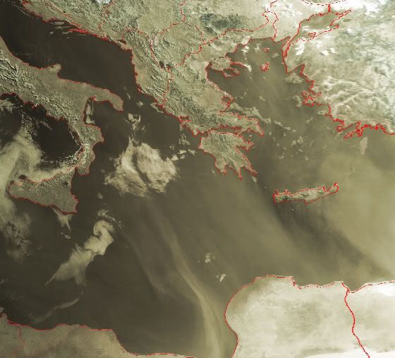
Dust Storm over the Persian Gulf
Dust lingered in the skies over the Persian Gulf on May 18, 2007. The Moderate Resolution Imaging Spectroradiometer (MODIS) on NASA’s Aqua satellite took this one day after a dust storm started over Saudi Arabia, Kuwait, Iran, and Iraq. In this image, buff-colored plumes of dust sweep from northwest to southeast over the water.
Dust lingered in the skies over the Persian Gulf on May 18, 2007. The Moderate Resolution Imaging Spectroradiometer (MODIS) on NASA’s Aqua satellite took this one day after a dust storm started over Saudi Arabia, Kuwait, Iran, and Iraq. In this image, buff-colored plumes of dust sweep from northwest to southeast over the water.

Dit vind ik wel heel,heel bizar.quote:Op maandag 26 maart 2007 14:55 schreef Frutsel het volgende:
Stofwolk boven België was Sahara-zand
[afbeelding]

Dust Plume off the Coast of Egypt
Dwarfing the Nile, a river of dust flowed out of the deserts of northern Egypt on May 19, 2007. As the Moderate Resolution Imaging Spectroradiometer (MODIS) on NASA’s Terra satellite passed overhead at 12:05 p.m. local time in Cairo, the sensor captured this image of the dust spreading northward over the Mediterranean Sea from the sandy deserts that span the country. At the margins of the plume, ribbons and ripples of dust are translucent, allowing a glimpse of the desert and water beneath, but in the center, the cloud is opaque, revealing nothing of the surface below.
The part of north-central Egypt hidden by the dust plume is the Qattara Depression, the country’s lowest point. Dipping down to 133 meters below sea level (436 feet), the depression is home to sandy deserts and dry lake beds that occasionally flood. The sand and fine, lake bed sediments are easily lofted into the air by strong winds that scour the area in late winter and early spring.
In the eastern (right-hand) part of the image, the Nile River is lined by narrow ribbons of dull green vegetation. The fan-shaped delta is dotted with tan-colored spots, marking the location of cities and towns. The Nile Valley and Delta make up only a small fraction of the country’s total land area, yet they support almost the entire population.

Smoke Plume over Eastern Canada
In late May, a massive smoke plume hundreds of kilometers across blew eastward over New Brunswick toward the Atlantic Ocean. On May 26, 2007, the Moderate Resolution Imaging Spectroradiometer (MODIS) on NASA’s Terra satellite captured this image at 11:40 a.m. local time. By the time MODIS took this picture, the smoke appeared to have completely detached itself from the source, a large fire burning in southwestern Quebec, beyond the western edge of this image.
In this image, the smoke appears as a gray-beige opaque mass with fuzzy, translucent edges. The plume is thickest in the southwest and diminishes toward the northeast. Just southwest of the plume is a red outline indicating a hotspot—an area where MODIS detected anomalously warm surface temperatures, such as those resulting from fires. This hotspot, however, is not the source for this smoke plume. According to a bulletin from the National Oceanic and Atmospheric Administration, the southwestern Quebec fire (visible in this wider-area view as a semi-circular arrangement of hotspots at image left) was the source.
According to reports from the Canadian Interagency Forest Fire Centre on May 29, that fire was estimated at 63,211 hectares (156,197 acres), and it was classified as “being held.” At the same time, more than 20 wildfires burned in Quebec, news sources reported, and firefighters from other Canadian provinces and the United States had been brought in to provide reinforcements for the area’s firefighters.

Dust Plume over Cape Verde
Dust blew off the west coast of Africa and over Cape Verde on June 17, 2007. The Moderate Resolution Imaging Spectroradiometer (MODIS) on NASA’s Terra satellite captured this image the same day. This picture shows the dust plume, hundreds of kilometers across, billowing over the Atlantic. Dust mingles with clouds over Cape Verde. To the west of the archipelago, clouds predominate.

Fruts dit is een tvp..dit wil ik ff lezen als ik tijd heb..
Love can move you..take you deeper everytime
Love can move you..to a place inside your heart
Love can move you..to a place inside your heart
Hoe komt het dat ze zo langzaam gaan?
In strips zijn zand- en stofstormen altijd heel gewelddadig en hard
In strips zijn zand- en stofstormen altijd heel gewelddadig en hard
Gelukkig ben ik gelukkig.
Treats me like a Cinderella, protects me from the storm like he's my umbrella
Treats me like a Cinderella, protects me from the storm like he's my umbrella
Hier nog een leuke van afgelopen week in Arizona USA
http://news.sky.com/skyne(...),30200-1275589,.html
http://news.sky.com/skyne(...),30200-1275589,.html

JULY 20 - Dust Plume off Western Africa
A thick plume of dust blew off the west coast of northern Africa on July 20, 2007. The Moderate Resolution Imaging Spectroradiometer (MODIS) flying on NASA’s Aqua satellite took this picture the same day. This image shows the beige-tan plume—thick enough to be completely opaque in places—over the Atlantic Ocean. The source of the plume is not obvious in this image, and given the plume’s diffuse shape, it may have originated farther east.
South of the plume, a wave pattern appears. Both airborne dust and clouds can make waves in the atmosphere visible to satellite sensors. The northern portions of these waves are faint, but as they meld with cloud formations in the south, the waves become easier to discern. Just north of the waves, the ocean water takes on a pale green color, which may be due to shallow water, sediment and/or algae.

JULY 16 - Saharan Dust Plume
Saharan dust blew off the west coast of Africa and over the Atlantic on July 16, 2007. The Moderate Resolution Imaging Spectroradiometer (MODIS) flying on NASA’s Terra satellite took this picture the same day. In this image, the dust forms a thick plume of tan that mingles with white clouds over the ocean. After blowing out over the water, the dust swirls back toward land in the south, forming an arc several hundred kilometers across

22 JUNE - Dust Plume off Western Africa
The Saharan dust plume that departed Africa on June 22, 2007, was hovering over the Caribbean Sea five days later. The Moderate Resolution Imaging Spectroradiometer (MODIS) on NASA’s Terra satellite took this picture on June 27, 2007. In this image, the dust appears as a very thin veil of brownish haze over the ocean.
17 JUNE -Dust Plume over Cape Verde
Dust blew off the west coast of Africa and over Cape Verde on June 17, 2007. The Moderate Resolution Imaging Spectroradiometer (MODIS) on NASA’s Terra satellite captured this image the same day. This picture shows the dust plume, hundreds of kilometers across, billowing over the Atlantic. Dust mingles with clouds over Cape Verde. To the west of the archipelago, clouds predominate.
=============
Vraag me af of deze Zandstormen enig effect hebben op de Orkanen in de Atlantische Oceaan richting de Golf (zie --> Hurricane season 2007 deel 2

Dust Storm over Afghanistan
On August 12, 2007, a dust storm formed where the borders of Iran, Afghanistan, and Pakistan meet. The Moderate Resolution Imaging Spectroradiometer (MODIS) flying on NASA’s Terra satellite took this picture the same day. This image shows the pale beige plumes of dust sweeping from the northwest in a counter-clockwise direction. The image also shows some of the source points for the plumes. From source points along the Iran-Afghanistan border, the storm covers part of northern Pakistan.

Coole pics...en mooie teksten erbij
Heb zelf weleens een mini zandstorm meegemaakt. We waren op vakantie op Gran Canaria. En we gingen toen slapen, volgende dag werden we wakker, hele tuin vol met zand, tuinmeubilair was niet meer zichtbaar, het was echt overal, we deden de schuifpui open, zootje zand naar binnen. Was heel apart. Ik was toen 12 ofzo.
Het stelt niet veel voor natuurlijk...maar het was weer eens wat anders
Zandstormen verwoesten deel Chinese Muur
PEKING - Zandstormen hebben tientallen kilometers van de Chinese Muur verwoest. Dat berichtte het persbureau Xinhua woensdag. In de noordoostelijke provincie Gansu is de afgelopen twintig jaar 40 kilometer Muur verdwenen, meldden archeologen.
In het district Minqin van Gansu is het gebied door te intensief landgebruik veranderd in een woestijn. Door zandstormen is de historische structuur ernstig beschadigd, aldus Xinhua. De Muur is 6400 kilometer lang en trekt jaarlijks 10 miljoen bezoekers.
Dit deel van de Chinese Muur was gemaakt van modder en niet van steen en wordt daardoor sneller aangetast, aldus voormalig curator Zhou Shengrui van het Minqin Museum. Elders in het land is de Muur ook aangetast door erosie, maar hier is het veel erger, zei hij.
http://www.telegraaf.nl/b(...)el_Chinese_Muur.html

Dust Storm over Bahrain and Qatar
Saudi Arabian dust blew over Bahrain, Qatar, and the Persian Gulf on September 12, 2007. The Moderate Resolution Imaging Spectroradiometer (MODIS) on NASA’s Terra satellite took this picture the same day. In this image, the dust appears as a pale beige arc moving in a clockwise direction. Although the dust is thin along the margins of the plume, near the center of the arc, it is thick enough to almost completely hide the island nation of Bahrain.
Zware zandstorm treft Californië
Een zandstorm heeft in Californië aan vier mensen het leven gekost. De mensen kwamen om het leven door verkeersongelukken.
In de zandstorm daalde het zicht plaatselijk tot nul meter. Hierdoor ontstonden behoorlijk wat aanrijdingen. Vooral Lancaster ten noorden van Los Angeles werd getroffen. De storm ging gepaard met windstoten van 90 kilometer per uur. Het gebied beleeft dit jaar een van de droogste tijden ooit.
vwk
opnieuw stofstorm voor Koeweit
Koeweit is voor de tweede keer in een week getroffen door een stofstorm. Door de stofstorm werden dinsdag drie havens gesloten en raakte het vliegverkeer ontregeld. Stofstormen zijn zeldzaam in de winter.
De stofstormen zijn een gevolg van de droogte. Normaal valt er in de winterperiode enige neerslag, maar de laatste maanden is dit in Koeweit minder voorgekomen. Hierdoor kon gemakkelijk zand en stof uit de woestijn worden aangevoerd.
Stofstormen ontstaan doorgaans in de zomer. Wanneer de shamalwind harder waait dan 25 kilometer per uur, worden zand- en stofdeeltjes meegevoerd. Dinsdag daalde het zicht tot minder dan 300 meter.
vwk
Ik heb eens gelezen dat, omdat de zon niet kan doordringen in zulke stormen, allerlei virussen e.d. kunnen overleven. Als zo'n storm dus een ander continent bereikt, kunnen zo ziektes verspreidt worden. Men vermoedt dat ook BSE op die manier is overgewaaid.
Inderdaad gaat de waarde die wij aan de mening van anderen hechten (...) in de regel bijna elke redelijke bedoeling te boven, zodat het als een soort algemeen verbreide of veeleer aangeboren manie kan worden beschouwd - Schopenhauer
China dust storm hits East Asia
The dust picks up toxins as it passes over Chinese factories
Yellow dust storm
A huge cloud of choking dust is passing over South Korea as the first sand storm of the year blows in from China. South Korea has ordered schools to close and drivers in south-west Japan have been warned about low visibility from the dust clouds.
Every spring brings "yellow dust" storms which blow sand from China's Gobi Desert over the Koreas and Japan.
The dust storms have become more deadly each year as they pass over China's industrial zones picking up toxins.
South Korea blames dozens of deaths every year on the storms, mostly of elderly people and those with respiratory problems.
South Korean authorities advised parents to keep younger children at home to avoid the dust.
"We have advised the closure because kindergarten, primary school students have weaker immune systems," Min Eyu-gi, an education official in the southern city of Busan, told Reuters news agency.
Seasonal winds lasting from late February to April or May combine with dry winter weather to pick up millions of tonnes of sand from China's northern deserts.
The storms turn the sky a yellow colour and coat everything in a layer of fine dust.
The dust picks up toxins as it passes over Chinese factories

Yellow dust storm
A huge cloud of choking dust is passing over South Korea as the first sand storm of the year blows in from China. South Korea has ordered schools to close and drivers in south-west Japan have been warned about low visibility from the dust clouds.
Every spring brings "yellow dust" storms which blow sand from China's Gobi Desert over the Koreas and Japan.
The dust storms have become more deadly each year as they pass over China's industrial zones picking up toxins.
South Korea blames dozens of deaths every year on the storms, mostly of elderly people and those with respiratory problems.
South Korean authorities advised parents to keep younger children at home to avoid the dust.
"We have advised the closure because kindergarten, primary school students have weaker immune systems," Min Eyu-gi, an education official in the southern city of Busan, told Reuters news agency.
Seasonal winds lasting from late February to April or May combine with dry winter weather to pick up millions of tonnes of sand from China's northern deserts.
The storms turn the sky a yellow colour and coat everything in a layer of fine dust.

Dust Storm at White Sands, New Mexico
On March 14, 2008, a dust storm struck southern New Mexico, near the borders with Texas and Mexico. The dust came from White Sands National Monument. At White Sands, pale gypsum sand covers some 715 square kilometers (275 square miles) of desert, providing ample material for storms when strong winds strike.
This image, acquired on March 14 by the Moderate Resolution Imaging Spectroradiometer (MODIS) on NASA’s Aqua satellite, shows the dust storm blowing eastward away from the national park. The white gypsum dunes contrast sharply with the surrounding landscape, and the dust plumes emerging from the park share the same characteristic color. Outside of the park, patches of green attest to the presence of vegetation, but the region is mostly arid, with earth tones predominating.

Dust Plumes over Syria and Iraq
A dust storm struck the Middle East in mid-March 2008, blowing primarily through Syria and Iraq. The Moderate Resolution Imaging Spectroradiometer (MODIS) on NASA’s Aqua satellite took this picture on March 15, 2008.
Clear skies over the Syrian coast and source points of the dust storm in the west indicate that the dust is blowing from west to east in this image. The dust plumes form an arc moving in counter-clockwise direction, barely grazing Jordan, and finally encountering clouds over Iraq

Dust over the Persian Gulf and Saudi Arabia
Dust plumes blew over the Persian Gulf and Saudi Arabia in mid-March 2008. The Moderate Resolution Imaging Spectroradiometer (MODIS) on NASA’s Terra satellite took this picture on March 14, 2008.
In this image, a thick plume of dust blows over Iran, the Persian Gulf, the island nation of Bahrain, and Saudi Arabia. The dust narrowly misses the Qatar Peninsula. Although source points for the plumes are not apparent in this image, the dust appears to blow from the north and move in a clockwise direction to the southwest. West of the most conspicuous dust plume, smaller plumes blow over Saudi Arabia. Clear skies immediately east of these smaller plumes suggest that the plumes originate within Saudi Arabia. Clouds appear over Iran in the upper right corner of this image, and they could be associated with the same weather system that stirred the dust.
Dust Storm off the African West Coast
On March 29, 2008, the Moderate Resolution Imaging Spectroradiometer (MODIS) on NASA’s Terra satellite captured this image of dust storm activity off the west coast of Africa. This image shows the second consecutive day’s dust plume activity off Africa’s coast. In this image, the dust, although thinner than that of the previous day, has spread over a wider range. The dust has both moved farther south, and skirted Cape Verde in the west.
NASA image courtesy Jeff Schmaltz, MODIS Rapid Response team. Caption by Michon Scott.
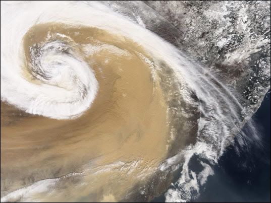
Deze gigantische stofstorm reisde in april 2001 vanuit Azië over de Stille Oceaan naar de Verenigde Staten.Bron: NASA
bron:
bron:

Dust Storm off Egypt
A thick plume of dust blew off the northern coast of Egypt, west of the Nile Delta, and over the Mediterranean Sea on September 25, 2008. The Moderate Resolution Imaging Spectroradiometer (MODIS) on NASA’s Aqua satellite captured this image the same day. In this image, the dust swirls in a counter-clockwise direction toward the northwest. A thinner plume in the east mimics the motion of the larger, thicker plume. Source points for this dust storm are not apparent in this image, but the dust likely arose from the sand seas farther inland in Egypt and/or Libya.
===
toch wel apart zon krul
|
|