NWS Nieuws & Achtergronden
Discussieer hier diepgaander over de actualiteiten.


De ontwikkeling van orkanen, typhoons en dergelijke horen in [WFL]-thuis.
De gevolgen zullen we hier in [NWS] gaan volgen.
Dat onderdelen achter deze discussies dubbel zullen gaan lopen is op zich niet zo erg. Maar voor een goed totaalbeeld is het wel interessant om beide topics te volgen.
900.000 mensen evacueren, dat zijn er nogal wat.quote:Typhoon kills eight in China, 99 fishermen missing
Bron : Reuters.com
SHANGHAI (Reuters) - A typhoon slammed into south China on Thursday killing eight people and forcing the evacuation of more than 900,000, Xinhua news agency said, while Vietnam was searching for 99 fishermen missing at sea.
Typhoon Chanchu, packing heavy rain and winds up to 170 kph (106 mph), made landfall between the cities of Shantou and Xiamen in the early morning, the Hong Kong Observatory said.
China's coastal provinces of Guangdong and Fujian took the full brunt of the storm.
Eight people were killed in Shantou, where Chanchu, the strongest typhoon on record to enter the South China Sea in May, triggered house collapses and landslides, Xinhua said.
Two children were among the dead, Xinhua reported, quoting local government sources.
Almost all roads in Shantou were flooded and there were several blackouts, Xinhua said, adding downpours in Fujian had led to flooding in a number of rivers.
State television news said Chanchu had been downgraded to a tropical storm and was heading northeast at a speed of only 25 kph but it would still bring strong rainfall to China's eastern provinces, including financial hub Shanghai.
Vietnam's National Search and Rescue Center, in a bulletin carried by the Voice of Vietnam radio station, said 99 fishermen aboard 11 ships last made radio contact on Wednesday morning some 160 nautical miles south of Hainan island, then in the storm's path.
Pham Quoc Te, a senior official at the center, said the coast guard and navy were leading a rescue mission, and officials had contacted authorities in China and Hong Kong for help.
"Because the typhoon is still very strong at the moment, it will take time for rescue teams to locate and approach the missing ships," Te told Reuters.
Typhoons, drawing strength from warm water, roar into China from the South China Sea every year between May and September, losing power once they make landfall.
Xinhua said more than 900,000 people in Guangdong and Fujian had been evacuated in the path of Chanchu, which killed at least 37 people when it swept through the Philippines at the weekend.
The eye of the storm crossed the Chinese coast halfway between Hong Kong and Taiwan, both often the victims of direct hits.
An ore-carrying Belgian ship with eight crew members was stranded offshore and a Chinese rescue vessel was expected to reach it on Thursday, state television said.
In Taiwan, rescuers winched to safety the crew of an oil tanker that had run aground off the coast of Kaoshiung after being hit by a large wave, television footage showed.
In the Philippines, Chanchu killed at least 37 people last weekend and "affected" about 53,300 people in wide areas of Luzon and the Visayas, the National Disaster Coordinating Council said.
Maar goed, we kunnen ons weer opmaken voor een stormachtig orkaan seizoen. En er zal weer veel leed voorbij trekken.
[ Bericht 1% gewijzigd door Drugshond op 19-05-2006 03:10:58 ]

PEKING - Het dodental in China door de tyfoon Chanchu (Parel) is vrijdag tot 23 opgelopen. Alleen in de Zuid-Chinese provincie Fujian werden al 10.000 huizen verwoest en moesten ruim drie miljoen mensen worden geëvacueerd Een dag eerder repten de autoriteiten nog van zestien slachtoffers
In de zuidelijke provincie Guandong eiste Chanchu acht levens, in Fujian vijftien, aldus de Chinese autoriteiten vrijdag. Chanchu geldt als de krachtigste tyfoon ooit in deze periode van het jaar in de regio. De wervelstorm eiste eerder op de Filippijnen ongeveer veertig levens. Voor de kust van Vietnam worden sinds woensdag vissersschepen met in totaal 22 bemanningsleden vermist.
In de zuidelijke provincie Guandong eiste Chanchu acht levens, in Fujian vijftien, aldus de Chinese autoriteiten vrijdag. Chanchu geldt als de krachtigste tyfoon ooit in deze periode van het jaar in de regio. De wervelstorm eiste eerder op de Filippijnen ongeveer veertig levens. Voor de kust van Vietnam worden sinds woensdag vissersschepen met in totaal 22 bemanningsleden vermist.
HET GAAT VAN START!!!!
Alberto Possible First Storm Already this weekend *hurricane track*
ALBERTO OVER THE WEEKEND? QUITE POSSIBLE
The latest outlook from the NHC suggests strongly that we will see our first tropical depression and possibly even our first named storm of the year. A broad and rather disorganized area of low pressure is persisting in the NW Caribbean Sea. The way things look now, it won't take much to transition this system in to a tropical depression or even a tropical storm. In fact, TS watches and/or warnings may be needed for portions of western Cuba this weekend. A recon plane will check out the low pressure area tomorrow as long as things still look as they do tonight. At that point, we will get a better feel for what is going on at the surface. Most model guidance suggests a track towards the western coast of Florida and then out in to the Atlantic next week. This could make for some nasty weather across portions of the coastal Southeast late in the weekend and in to next week. While we are not currently looking at a hurricane problem, we certainly need to be on top of what develops- you never know. I'll post more here tomorrow morning from Mt. Pleasant, SC at the Lowe's hurricane readiness fair. If you live nearby, come on out and say hello. We'll be there from 10am until 2pm.
Voor meer Storminfo en nieuws ---> [WFL] Hurricane Season 2006
Nou...daar is ALBERTO dan ook op kaart...en tis er ook eentje die voor de OostKust van de VS voor wat overlast kan gaan zorgen... iets wat ze al voorspeld hadden... maar het schijnt nog te vroeg te zijn voor een 'monster' storm
[ Bericht 3% gewijzigd door Frutsel op 11-06-2006 20:43:29 ]

[ Bericht 3% gewijzigd door Frutsel op 11-06-2006 20:43:29 ]
De tropische depressie AL1 is zondag opgewaardeerd tot de tropische storm Alberto. Het systeem heeft in het westen van Cuba voor veel regen gezorgd. In Pinar del Río werd zondagochtend 445 millimeter afgetapt. In Sumidero viel 398 millimeter. Veel andere weerstations in het westen gaven neerslaghoeveelheden door tussen de 200 en 400 millimeter.
bron:
bron:

Alberto checkt de Cuba..
En die mensen hebben het al zo goed.quote:Eerste tropische storm in Caribisch gebied
MIAMI - Boven de Golf van Mexico is de eerste tropische storm van het Atlantische orkanenseizoen ontstaan. Dat heeft het orkanencentrum van de Amerikaanse weerkundige dienst zondag bekendgemaakt. De storm, die de naam Alberto heeft gekregen, koerst af op de westkust van de Amerikaanse staat Florida. Naar verwachting zal de tropische storm dinsdag over Florida trekken. Het orkanencentrum in Miami voorspelt voor de komende twee dagen veel neerslag.
Alberto heeft de westkust van Cuba al geteisterd met hevige regen. Cica 26.000 mensen moesten hun huizen tijdelijk verlaten. Op sommige plaatsen is meer dan 50 centimeter water gevallen. Vooral het eiland Juventud is getroffen. Rond het oog worden windsnelheden waargenomen van ruim 75 kilometer per uur. De storm verplaatst zich met een snelheid van 15 kilometer per uur richting de Amerikaanse kust.
Het Atlantische orkanenseizoen is op 1 juni begonnen en loopt door tot eind november. Het seizoen van 2005 was het zwaarste sinds de weerkundige dienst in de VS gegevens bijhoudt. Er ontstonden in het westen van de Atlantische Oceaan 28 tropische stormen, waarvan er vijftien uitgroeiden tot orkanen.
Mjah... heb ik al genoeg over gezegd... ga ut nie nog eens doenquote:Op maandag 12 juni 2006 22:03 schreef highway101 het volgende:
waarom zijn er eigenlijk 2 topics over? [WFL] Hurricane Season 2006
Zie OP... of ask Drugshond
okay. Al vermoedt ik dat bij een Rita/Katrina-achtige, daar wel een nieuw topic over zal komen
/ ¦ ¦ / ¦ ¦
daar zou deze dus voor moeten zijn... want anders snap ik het echt niet meer...quote:Op maandag 12 juni 2006 22:20 schreef highway101 het volgende:
okay. Al vermoedt ik dat bij een Rita/Katrina-achtige, daar wel een nieuw topic over zal komen
[paarse krokodil mode]
Idd voor rampen en slachtoffers staat het topic hier.
[/paarse krokodil mode]
Er zullen idd wat items dubbel lopen (omdat het ook nieuwswaardig is). Bij echte klappers is zelfs een seperaat topic mogelijk (Katrina, Rita). Wat de ideale vorm is zullen we empirisch moeten vaststellen. Maar op dit moment is 1 centraal topic voldoende.
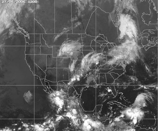
Hurricane Ernesto on track to hit Florida
Sunday, August 27, 2006; Posted: 8:48 a.m. EDT (12:48 GMT)
Ernesto became the first hurricane of the 2006 season on Sunday and is forecast to hit central or northern Florida by Thursday morning.
Hurricane Ernesto had top winds of 75 mph at 5 a.m. ET, according to Lt. Jennifer Pralgo, a meteorologist at the National Hurricane Center.
The latest advisory from the hurricane center said conditions in the Gulf were "highly conducive" for the "rapid intensification in the near term and for the potential development of a major hurricane in the longer term." (Watch where Ernesto is likely to hit -- 1:03)
Earlier fears that Ernesto might barrel toward New Orleans, near the anniversary of Katrina's landfall, were eased with the latest advisory, but it was bad news for residents of central and northern Florida.
Ernesto is now forecast to make landfall as a major category 3 storm on the coast of Florida, move northeastward and still be a category 1 storm well inland.
A tropical storm watch may be issued for the western portion of the Florida Keys sometime Sunday, according to the discussion notes issued by the hurricane center.
Just how powerful the hurricane becomes will be "highly dependent on the exact track that Ernesto takes due to land interaction with Haiti and Cuba," the center said.
[b]"If Ernesto doesn't linger over Cuba for more than 24 hours, then major hurricane strength seems likely" by Thursday or Friday, the hurricane center said.[b]
As of 5 a.m. ET Sunday, the storm was centered about 120 miles south-southwest of Port au Prince, Haiti, and it was moving at 9 mph toward the west-northwest, the center said.
Hurricane Ernesto's center should "pass very near" the southwestern tip of Haiti Sunday afternoon or early evening and be near Cuba's southeastern coast Monday morning, the hurricane center said.
============================
Afwachten dus wat Ernesto boven Cuba gaat doen... New Orleans wordt in elk geval gespaard, ook daar waren ze in het begin bang voor.
Terwijl het Seizoen veel minder 'heftig' lijkt uit te pakken dan voorspeld was, wordt dit waarschijnlijk de eerste echte storm die land gaat treffen. Cuba maakt zich klaar, daarna volgt Florida
Sunday, August 27, 2006; Posted: 8:48 a.m. EDT (12:48 GMT)
Ernesto became the first hurricane of the 2006 season on Sunday and is forecast to hit central or northern Florida by Thursday morning.
Hurricane Ernesto had top winds of 75 mph at 5 a.m. ET, according to Lt. Jennifer Pralgo, a meteorologist at the National Hurricane Center.
The latest advisory from the hurricane center said conditions in the Gulf were "highly conducive" for the "rapid intensification in the near term and for the potential development of a major hurricane in the longer term." (Watch where Ernesto is likely to hit -- 1:03)
Earlier fears that Ernesto might barrel toward New Orleans, near the anniversary of Katrina's landfall, were eased with the latest advisory, but it was bad news for residents of central and northern Florida.
Ernesto is now forecast to make landfall as a major category 3 storm on the coast of Florida, move northeastward and still be a category 1 storm well inland.
A tropical storm watch may be issued for the western portion of the Florida Keys sometime Sunday, according to the discussion notes issued by the hurricane center.
Just how powerful the hurricane becomes will be "highly dependent on the exact track that Ernesto takes due to land interaction with Haiti and Cuba," the center said.
[b]"If Ernesto doesn't linger over Cuba for more than 24 hours, then major hurricane strength seems likely" by Thursday or Friday, the hurricane center said.[b]
As of 5 a.m. ET Sunday, the storm was centered about 120 miles south-southwest of Port au Prince, Haiti, and it was moving at 9 mph toward the west-northwest, the center said.
Hurricane Ernesto's center should "pass very near" the southwestern tip of Haiti Sunday afternoon or early evening and be near Cuba's southeastern coast Monday morning, the hurricane center said.

============================
Afwachten dus wat Ernesto boven Cuba gaat doen... New Orleans wordt in elk geval gespaard, ook daar waren ze in het begin bang voor.
Terwijl het Seizoen veel minder 'heftig' lijkt uit te pakken dan voorspeld was, wordt dit waarschijnlijk de eerste echte storm die land gaat treffen. Cuba maakt zich klaar, daarna volgt Florida
Nou, hij gaat wel een paar keer geheel of gedeeltelijk over land (Cuba, Haiti), en over land nemen ze over het algemeen niet in kracht toe. Boven open zee kan hij/zij snel uitgroeien, zoals je destijds met Rita en Katrina zag.quote:Op zondag 27 augustus 2006 16:07 schreef aloa het volgende:
Ik ben benieuwd hoe zwaar deze eerste orkaan wordt.
[afbeelding]
/ ¦ ¦ / ¦ ¦
MIAMI - De autoriteiten in Florida hebben de evacuatie bevolen van alle toeristen op de eilandengroep Florida Keys aan de zuidkust van de Amerikaanse staat. Het gebied ligt in het voorspelde pad van de orkaan Ernesto, die zich zondag boven de Caribische Zee ten zuiden van Haïti bevond.
Aan de zuidkust van Haïti en in delen van Cuba is een orkaanwaarschuwing van kracht. Jamaica haalt opgelucht adem. De orkaan lijkt het eiland niet rechtstreeks te treffen. Recente modellen van de Amerikaanse meteorologische dienst geven aan dat Ernesto in noordwestelijke richting over Cuba en langs de westkust van Florida trekt.
De Cubaanse autoriteiten zijn begonnen met de evacuatie van circa 200.000 mensen uit de oostelijke provincies. Ook heeft het zijn visservloot teruggeroepen naar de havens. Ernesto bereikt naar verwachting maandagochtend het communistische eiland.
Zware regenval
Elders in het Caribisch gebied, met name in Haïti, veroorzaakte Ernesto zondag zware regenval. Dat straatarme land is door ontbossing extreem kwestbaar voor overstromingen en aardverschuivingen. Modderstromen als gevolg van tropische storm Jeanne eisten er twee jaar geleden 3000 mensenlevens.
Ernesto viel zondag in de eerste en lichtste categorie op de schaal van Saffir-Simpson, maar zal waarschijnlijk nog aan kracht winnen. Van de tot dusver vijf tropische stormen in het Atlantische stormseizoen is Ernesto de eerste die is uitgegroeid tot een orkaan.
Touroperator TUI heeft 350 toeristen op Cuba en een handjevol op de Florida Keys. Het bedrijf neemt vooralsnog geen maatregelen.
"We houden de boel natuurlijk nauwlettend in de gaten", aldus een woordvoerster. Thomas Cook denkt dat er nog niets aan de hand is. "De autoriteiten nemen altijd het voortouw bij dit soort dingen."
Thomas Cook heeft wel toeristen op Cuba, maar niet op de Florida Keys.

MIAMI - De orkaan Ernesto, die in de buurt van Haïti over de Caribische Zee raast, is zondagavond afgezwakt tot een tropische storm. Dat heeft het orkanencentrum van de Amerikaanse weerkundige dienst in Miami meegedeeld. De eerder uitgegeven orkaanwaarschuwingen voor delen van Haïti en Cuba blijven desondanks van kracht.
Gouverneur Jeb Bush van Florida riep zondag uit voorzorg de noodtoestand uit. Daardoor komt de zuidelijke Amerikaanse staat in aanmerking voor federale noodhulp als Ernesto er zware schade aanricht. De autoriteiten hebben al de evacuatie gelast van alle toeristen op de eilandengroep Florida Keys. Het gebied ligt op het voorspelde pad van de tropische storm.
Ernesto viel zondag in de eerste en lichtste categorie op de schaal van Saffir-Simpson. Aanvankelijk voorspelden experts dat de storm nog aan kracht zou winnen, maar het tegendeel gebeurde. Van de tot dusver vijf tropische stormen in het Atlantische stormseizoen is Ernesto de eerste die is uitgegroeid tot een orkaan. Het is niet uitgesloten dat de storm de komende dagen opnieuw orkaankracht bereikt.
Nu.nl


KEY WEST, Fla. — The National Hurricane Center posted a hurricane watch on Monday for the southern tip of the Florida Peninsula, including the Keys and the Miami area, as Tropical Storm Ernesto drew closer and threatened to strengthen.
The watch — in effect south of Deerfield Beach, near Boca Raton, on the east coast and south of Chokoloskee on the west coast — meant hurricane conditions with sustained wind of at least 74 mph were possible within 36 hours.
The Florida Keys were put under a watch Sunday afternoon.
The area was extended north of the Keys because Ernesto could become a hurricane again after it reaches the warm water north of Cuba, the hurricane center said. Forecasters said there was a 10 percent chance of hurricane-force wind striking South Florida and a 60 percent chance of tropical storm-force wind.
Gov. Jeb Bush had already issued a state of emergency on Sunday for all of Florida, which has been hit by seven hurricanes and brushed by another in the past two years.
[ Bericht 6% gewijzigd door Frutsel op 28-08-2006 16:18:15 ]
However, the NHC is forecasting Ernesto to reach hurricane strength once it hits the water again tomorrow (after coming off of Cuba) and they note that there is concern that Ernesto could strengthen much more if it gets over the bath-water quicker than forecast. This puts south Florida at quite a disadvantage as far as what to expect. I must emphasize that the NHC forecaster states that upperl level conditions would be "very favorable" just as Ernesto approaches the Florida coast. The risk is huge- we can hope that the storm remains weak and does not get that chance to become an intense hurricane- but it can happen and people in south Florida need to be ready for that possibility. Once Ernesto moves inland, it will spread heavy rain and destructive winds northward in to major population areas of Florida. Again, how strong it is when it hits will make a huge difference in what the remainder of the peninsula can expect.quote:

Even een kort berichtje. Als jullie actuele radarbeelden willen vanaf Cuba waarop Ernesto te volgen is moet je even het volgende adres bezoeken...
Radar Cuba
Ernesto zal ws niet zo zwaar worden, maar wel de nodige overlast bezorgen qua water. Op dit moment is er geen oog meer, maar activeert hij straks boven water weer. Het kan zijn dat hij op de Atlantische Oceaan terechtkomt , maar dan weer afbuigt naar de westkust. Maar goed, dat is speculatie op dit moment...
Squelch - a circuit that cuts off the audio-frequency amplifier of a radio receiver in the absence of an input signal, in order to suppress background noise.
Groeten vanuit Florida (nee dat is geen grap)
Valt allemaal reuze mee waarschijnlijk een tropisch storm als het orlando zal bereiken waar ik zit.
Valt allemaal reuze mee waarschijnlijk een tropisch storm als het orlando zal bereiken waar ik zit.
quote:Op donderdag 18 mei 2006 12:23 schreef Gunner het volgende:
Ik ga het topic in de gaten houden. In augustus ga ik naar Florida
Where law ends, tyrrany begins.
Tropical Storm Ernesto remains weak over Cuba but may emerge back over warm water overnight.quote:Op dinsdag 29 augustus 2006 04:43 schreef Gunner het volgende:
Groeten vanuit Florida (nee dat is geen grap)
Valt allemaal reuze mee waarschijnlijk een tropisch storm als het orlando zal bereiken waar ik zit.
[..]

Het kan dus nog wel, Ernesto gaat over 'warm' water wat de boel weer wat kan versnellen.
Hou je paraplu goed vast!
Patience is not one of my virtues, neither is memory. Or patience for that matter.
Ik moet de docu/film van Spike Lee nog bekijken, 'When the levees broke" . Ben e.e.a. aan het converteren naar DVD. Maar het ziet er indrukwekend uit.quote:Psychische klachten verdubbeld door Katrina
Bron : Nu.Nl
Uitgegeven: 29 augustus 2006 06:14
BOSTON - Het aantal mensen met psychische problemen in de Amerikaanse gebieden die precies een jaar geleden werden getroffen door de orkaan Katrina, is het afgelopen jaar verdubbeld. Dat blijkt uit een onderzoek van de universiteit van Harvard dat maandag openbaar werd gemaakt.
Bij vijftien procent van 1043 overlevenden werd vijf tot acht maanden na de ramp vastgesteld dat er sprake was van ernstige psychische problemen. "Dat cijfer suggereert dat ongeveer 200.000 inwoners van Alabama, Louisiana en Mississippi kampen met mentale problemen door Katrina", aldus onderzoeker Ronald Kessler.
Zelfmoord
Opvallend genoeg speelden volgens het onderzoek juist minder mensen met de gedachte zelfmoord te plegen. Katrina zou volgens de wetenschappers een sterk gevoel van onderlinge verbondenheid teweeg hebben gebracht.
Bush
De orkaan, die op 29 augustus over het zuiden van de Verenigde Staten raasde, kostte aan ongeveer 1500 mensen het leven en verwoestte New Orleans. Dinsdag bezoekt president Bush de stad die nog lang niet de oude is. "Dit is een gedenkdag, maar dat betekent niet dat het een einde is. Het is enkel het begin van een lange weg naar herstel", zei Bush maandag in Mississippi tijdens een toespraak.
De regering Bush kreeg het afgelopen jaar veel kritiek te verduren over de hulpverlening na de ramp. "Wij begrijpen dat mensen nog steeds bang zijn om hun huizen in te gaan. Dat mensen horen over hulp en zich afvragen waar die blijft", aldus Bush. De president liet weten dat het herstel van het gebied "niet maanden, maar jaren" zal duren.

Niemand hier die ik spreek maakt zich druk. Het gaat hooguit flink waaien en regenen.quote:Op dinsdag 29 augustus 2006 05:03 schreef popolon het volgende:
Het kan dus nog wel, Ernesto gaat over 'warm' water wat de boel weer wat kan versnellen.
Hou je paraplu goed vast!
Where law ends, tyrrany begins.

We vergeten SUPERTYFOON IOKE...
windsnelheden van 140 mph en vlagen van 170 mph (325 km/u !!!!!)...
en ze gaat recht op WAKE ISLAND af....daar blijft nix van over...
windsnelheden van 140 mph en vlagen van 170 mph (325 km/u !!!!!)...
en ze gaat recht op WAKE ISLAND af....daar blijft nix van over...

Wake is tegenwoordig een US-air force base.
http://en.wikipedia.org/wiki/Wake_Island
En ja ze zijn al weg.
http://en.wikipedia.org/wiki/Wake_Island
En ja ze zijn al weg.
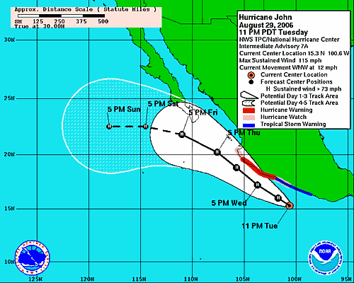
Eentje die pijn kan doen.quote:Category 4 Hurricane John threatens Mexico
Bron : CNN
• Category 4 John has top sustained winds of 135 mph
• Storm center located 130 miles south of Manzanillo
• Hurricane watch issued for 300 miles of Mexican coast
• Forecasters predict landfall Wednesday near Puerto Vallarta
PUERTO VALLARTA, Mexico (AP) -- Hurricane John lashed tourist resorts with heavy winds and rain Wednesday as the dangerous storm marched up Mexico's Pacific coast, and forecasters predicted its center would brush close to land before nicking the tip of Baja California and heading out to sea.
Forecasters warned the Category 4 hurricane could dump up to a foot of rain along parts of Mexico's southern coast, causing landslides or flooding. The hurricane had maximum sustained winds of 135 mph and stronger gusts capable of ripping roofs off buildings and causing storm surges of up to 18 feet above normal.
John was not expected to affect the United States -- cooler Pacific waters tend to diminish the storms before they reach California. But a hurricane warning covered a more than 300-mile stretch of the Mexican coastline from the port city of Lazaro Cardenas north to Cabo Corrientes, the southwestern tip of the bay that holds Puerto Vallarta. (Path)
The government also issued a hurricane watch for portions of the southern Baja Peninsula, from La Paz south on the east coast and from Sante Fe south on the west coast, an area which includes the resort city of Cabo San Lucas.
So far, the most damaging winds have remained offshore, and only tropical storm-force winds have hit the coast.
In Puerto Vallarta, skies were clear and tourists relaxed on the beach. But officials postponed the arrival of a Carnival cruise chip and prohibited customary tours of the bay.
William Rousseau, a tourist from Oregon vacationing with his family in Puerto Vallarta, said hotel officials had warned about John, "but we're calm because they say it's not going to hit this city."
"We're continuing to enjoy the city," he said. "They just asked us not to go into the ocean or on any bay tours."
Other tourists could be seen strolling through the streets visiting craft shops and eating in restaurants.
The area south of Lazaro Cardenas to Acapulco was under a tropical storm warning. Tropical storm-force winds were lashing Lazaro Cardenas and the resort of Ixtapa-Zihuatanejo.
Although the center of John was forecast to remain just offshore, hurricane-force winds were likely to begin raking beaches near Puerto Vallarta late Wednesday, the National Hurricane Center in Miami said. The storm was then expected to nick Los Cabos at the tip of the Baja California Peninsula on Friday before heading out to sea.
The Mexican army and emergency services were on alert all along the coast. The civil protection agency for the state of Jalisco, which includes Puerto Vallarta, announced it would ask 8,000 residents living in risk-prone coastal areas to evacuate voluntarily to 900 temporary shelters. Those who refused would be moved by police officers, the government agency Notimex reported.
Mexican forecasters predicted up to 10 inches of rain on the coast and "torrential downpours" in the Jalisco state capital of Guadalajara, Notimex said. Public schools were canceled in Acapulco and surrounding communities.
In the resort cities of Ixtapa and Zijuatanejo, about three hours up the coast from Acapulco, authorities closed the port to small ocean craft and set up temporary shelters. Some students decided to leave school early before any potential flooding.
Light rain fell in Ixtapa, where the five-star Emporio Hotel received only minor warnings of rising tides. Receptionist David Gonzalez said none of the hotel's 92 guests had said they would leave early.
Pedro Ochoa, reception clerk at the four-star Posada Real Ixtapa Hotel, said neither staff nor guests were making any special preparations for the storm because "we were advised that it was headed elsewhere."
The center of the hurricane in late afternoon was about 130 miles south of the resort of Manzanillo, and was moving to the northwest at close to 14 mph.
Meanwhile, a second weather system, Tropical Storm Kristy, formed in the Pacific far off the Mexican coast early Wednesday, but was forecast to move farther out to sea with no threat to land, the Hurricane Center said. Kristy had maximum sustained winds of 58 mph and was moving northwest at about 6 mph.

PUERTO VALLARTA, Mexico — Hurricane John churned parallel to Mexico's resort-studded Pacific Coast, lashing beaches with winds and rain and plotting a course that could take its center close to land before nicking the tip of Baja California.
Authorities in Puerto Vallarta, among Mexico's most-visited resorts, scrambled to prepare emergency shelters while organizing night patrols to hunt for possible storm-related damage late Wednesday. But tourists and residents alike remained calm

HONOLULU — Typhoon Ioke, the strongest Central Pacific tropical storm in more than a decade, continued to barrel toward recently evacuated Wake Island without losing any of its power.
Forecasters say the storm, which is now threatening no populated islands, is predicted to submerge the tiny atoll and destroy everything on it that is not concrete.
"It's a monster storm," said Jeff Powell, National Weather Service lead forecaster.
The isle's entire population of some 200 residents left via two Air Force evacuation flights to Hawaii on Monday. All were either U.S. military personnel, defense department civilians or military contractors.
The typhoon is expected to reach Wake Island at 1100 GMT Thursday with winds of up to 161 mph and gusts of up to 195 mph.
Ioke will likely pound Wake Island with powerful winds and rain for about 10 to 12 hours if the storm continues to move forward at current speeds, Powell said.
After hitting Wake Island, forecasters expect Ioke to head northwest over open ocean for several days in the direction of Japan. The typhoon will likely gradually lose power along the way, with its wind speeds expected to drop to 120 mph by early Monday
[ Bericht 0% gewijzigd door Frutsel op 01-09-2006 10:39:35 ]
tvp
m'n broertje is de komende paar maand aan het werk op een cruiseschip in de Caribbean...Bahamas, Mexico en thuishavens zijn Port Canaveral en New Orleans wel interessant om een beetje het Hurricane Season in de gaten te houden!
m'n broertje is de komende paar maand aan het werk op een cruiseschip in de Caribbean...Bahamas, Mexico en thuishavens zijn Port Canaveral en New Orleans wel interessant om een beetje het Hurricane Season in de gaten te houden!
Ik hoop van harte dat het dit jaar een beetje mee gaat vallen met de orkanen, gun ze wel een jaartje rust daar, wat een ellende was het vorig jaar zeg!
Orkaan John veroorzaakt paniek in Mexico
(Novum/AP) - De Mexicaanse autoriteiten hebben donderdag tienduizend inwoners van de toeristenoorden San José del Cabo en Cabo San Lucas opdracht gegeven zich uit de voeten te maken, omdat orkaan John eraan komt.
Wanhopige toeristen stonden in lange rijen op het vliegveld van San José del Cabo in een poging op tijd weg te komen uit de gevarenzone. Orkaan John heeft woensdag en donderdag de stranden aan de Pacifische kust doorweekt en bereikt vrijdag mogelijk de toeristenoorden op het schiereiland Neder-Californië.
Winkeleigenaars in Cabo San Lucas barricadeerden ramen en er werden vijftien schuilkelders ingericht. Inwoners sloegen voedsel en water in en stonden in de rij voor benzine.
Nieuws.nl

Hoe kan het dat er al een John is (geweest) en dat Florence eraan komt ? Ze worden toch op alphabetische volgorde benoemd ?quote:Op zondag 3 september 2006 21:23 schreef Frutsel het volgende:
Tropical Storm Florence komt eraan...
waarschijnlijk binnen 24 uur wordt ze 'benoemd'...
The Hick from French Lick
The camera always points both ways. In expressing the subject, you also express yourself.
The camera always points both ways. In expressing the subject, you also express yourself.
Jep, dit kan wel, (zie de openingspost van het WFL topic [WFL] Hurricane Season 2006 #2 zijn de Atlantische Stormen anders genoemd dan de Oost-Pacifische (net als de West Pacifische) In die OP staan de beide namen lijst voor zowel de Westkust van de VS en de Atlantische/Golf v.Mexico/Oostkust stormenquote:Op maandag 4 september 2006 20:28 schreef elcastel het volgende:
[..]
Hoe kan het dat er al een John is (geweest) en dat Florence eraan komt ? Ze worden toch op alphabetische volgorde benoemd ?
[ Bericht 5% gewijzigd door Frutsel op 04-09-2006 20:41:27 ]
Indeling en Kracht
De stormen worden ingedeeld op categorie. Vaak zijn het eerst "tropische stormen" (Tropical Depression, Tropical Storms), die overgaan op Orkaanstatus (Hurricane) Ze worden ingedeeld op windsnelheden via de Saffire Simpson Schaal
Tropical Depression 24-38 mph winds (38-61 km/u)
Tropical Storm 39-73 mph winds (62-118 km/u)
Hurricane Categorie 1 74-95 mph winds (119-153 km/u) -- 4/5 ft Storm Surge -- Vb. Danny 1997, Stan 2005
Hurricane Categorie 2 96-110 mph winds (154-177 km/u) - 6/8 ft Storm Surge -- Vb. Danielle 2004
Hurricane Categorie 3 111-130 mph winds (178-209 km/u) -- 9/12 ft Storm Surge -- Vb.Fran 1996, Beta 2005
Hurricane Categorie 4 131-155 mph winds (210-249 km/u) -- 13/18 ft Storm Surge -- Vb.Hugo 1989, Frances 2004
Hurricane Categorie 5 > 156 mph winds (meer dan 250 km/u) -- 18ft or more S.S. -- Vb.Andrew 1992, Mitch 1998 en Wilma, Katrina 2005
Namen
De stormen, die vaak gevormd worden op de atlantische oceaan en dan richting de Caribbean of de Oostkust van de VS gaan, krijgen de naam op Alfabetische volgorde. Voor het seizoen 2005 zijn de namen als volgt:
Atlantische Stormen 2006
Alberto, Beryl, Chris, Debby, Ernest, Florence, Gorden, Helene, Isaac, Joyce, Kirk, Leslie, Michael, Nadine, Oscar, Patty, Rafael, Sandy, Tony, Valerie, William
In het oosten van de pacific ontstaan ook Hurricanes, ook wel Cylonen en/of Tyfoons genoemd. Deze zorgen vaak voor weinig schade aan de Amerikaanse westkust.
Oost Pacifische Stormen 2006
Aletta, Bud, Carlotta, Daniel, Emilia, Fabio, Gilma, Hector, Ileana, John, Kristy, Lane, Miriam, Norman, Olivia, Paul, Rosa, Sergio, Tara, Vicente, Willa, Xavier, Yolanda, Zeke
Orkaan Lane eist levens in Mexico
CULIACAN - De orkaan Lane heeft zaterdag in het westen van Mexico twee levens geëist. Lane kwam als een zware orkaan van de categorie 3 aan land met windsnelheden tot 200 kilometer per uur. Inmiddels is hij afgezwakt tot een orkaan van de eerste categorie met windsnelheden tot 145 kilometer per uur.
De lokale autoriteiten in de deelstaat Sinaloa vrezen overstromingen en aardverschuivingen door de zware regenval. Volgens burgemeester Aaron Irizar Lopez van Culiacan lopen 40.000 tot 50.000 mensen in Sinaloa die in de buurt van rivieren wonen gevaar.
Bron: Nu.NL
Tyfoon Shanshan heeft vanochtend het Japanse eiland Kyushu bereikt. Het oog trok op zo'n twintig kilometer langs Nagasaki, waar op het vliegveld een windsnelheid van 40 m/s (140 km/u) werd gemeten met windstoten tot boven de 180 km/u.
Er worden vijf doden gemeld en tientallen gewonden. Bij Miyazaki werd een trein met 45 passagiers van de rails geblazen, mogelijk door een tornado. De Japanse weerdienst verwacht dat de tyfoon 400 mm neerslag binnen 24 uur zal brengen.
Shanshan zal verder afzwakkend in noordoostelijke richting over de Japanse Zee trekken. Het restant van de tyfoon kan dan over enkele dagen ten oosten van Vladivostok (Rusland) weer aan land komen.
bron
GORDON
gaat dus voor veel overlast zorgen op de Azoren en daarna richting Portugal/Spanje
MIAMI — Hurricane Gordon weakened Tuesday as it sped toward the sparsely populated Azores islands, which were under a hurricane warning, while a powerful Hurricane Helene was expected to stay out at sea, forecasters said.
Gordon was downgraded to a Category 1 hurricane with top sustained winds near 85 mph late in the morning, down from a Category 2 with 100 mph winds earlier in the day, according to the National Hurricane Center in Miami.
At 2 p.m. EDT, it was centered about 380 miles west of the island of Terceira in the Azores, and moving east at near 31 mph.
Gordon was expected to retain hurricane strength as it neared the islands off the Atlantic coast of Africa later Tuesday, forecasters said. Two to 4 inches of rain were expected, with higher terrain possibly getting 6 inches.
Forecasters said Gordon should then be absorbed by a larger weather system that was expected to approach northwestern Portugal and Spain on Thursday.
gaat dus voor veel overlast zorgen op de Azoren en daarna richting Portugal/Spanje

MIAMI — Hurricane Gordon weakened Tuesday as it sped toward the sparsely populated Azores islands, which were under a hurricane warning, while a powerful Hurricane Helene was expected to stay out at sea, forecasters said.
Gordon was downgraded to a Category 1 hurricane with top sustained winds near 85 mph late in the morning, down from a Category 2 with 100 mph winds earlier in the day, according to the National Hurricane Center in Miami.
At 2 p.m. EDT, it was centered about 380 miles west of the island of Terceira in the Azores, and moving east at near 31 mph.
Gordon was expected to retain hurricane strength as it neared the islands off the Atlantic coast of Africa later Tuesday, forecasters said. Two to 4 inches of rain were expected, with higher terrain possibly getting 6 inches.
Forecasters said Gordon should then be absorbed by a larger weather system that was expected to approach northwestern Portugal and Spain on Thursday.
|
|