WFL Wetenschap, Filosofie, Levensbeschouwing
Discussieer hier over alle aspecten van de wetenschap, filosofische problemen en zaken van levensbeschouwelijke aard.


beste storm-trekkies
Heeft iemand van jullie een goeie site om de typhoons in de Pacific te volgen?
Heb deze site momenteel in gebruik, maar die is nogal summier. http://www.wunderground.com/tropical/tracking/wp200519.html
Het lijkt erop dat typhoon Longwang Taiwan vol zal raken. Volgens ik me goed herinner is dit niet de eerste typhoon die deze koers volgt.
Weet iemand hoeveel typhoons het juist zijn en in hoeverre is dit uitzonderlijk ?
Wat sites met info en satelietbeelden van de Western Pacific..
http://www.npmoc.navy.mil/jtwc.html
http://www.solar.ifa.hawaii.edu/Tropical/
Op deze site kan je de stormen van de laatste zoveel jaar nakijken in de Western Pacific, met hun kracht en ook hun 'pad' dat ze gevolgd hebben. hopelijk heb je daar wat aan Francorex
http://weather.unisys.com/hurricane/
Op onderstaande site kan je de stormen bekijken uit 2005 alleen
http://weather.unisys.com/hurricane/w_pacific/2005/


Wow die is even krachtig geworden, moet je die windvelden eens zien
Doe mee met het voorspellen van het weer!
Weekvoorspelling | Week 42 (Inschrijven tot 6-10, 11:59)
Maandvoorspelling oktober (Gesloten)
Jaarvoorspelling 2024 / 2025
Weekvoorspelling | Week 42 (Inschrijven tot 6-10, 11:59)
Maandvoorspelling oktober (Gesloten)
Jaarvoorspelling 2024 / 2025
Doe mee met het voorspellen van het weer!
Weekvoorspelling | Week 42 (Inschrijven tot 6-10, 11:59)
Maandvoorspelling oktober (Gesloten)
Jaarvoorspelling 2024 / 2025
Weekvoorspelling | Week 42 (Inschrijven tot 6-10, 11:59)
Maandvoorspelling oktober (Gesloten)
Jaarvoorspelling 2024 / 2025
Zo te lezen kan ie elk moment opgewaardeerd worden tot Cat 5 ja en gaat als Cat 4 aan land...quote:Op zaterdag 1 oktober 2005 17:15 schreef Hallulama het volgende:
Is dat dol, dwaze ding nog steeds of inmiddels CAT5?
en daar is Stan!
 en daar is Stan!
Doe mee met het voorspellen van het weer!
Weekvoorspelling | Week 42 (Inschrijven tot 6-10, 11:59)
Maandvoorspelling oktober (Gesloten)
Jaarvoorspelling 2024 / 2025
Weekvoorspelling | Week 42 (Inschrijven tot 6-10, 11:59)
Maandvoorspelling oktober (Gesloten)
Jaarvoorspelling 2024 / 2025
MIAMI, Florida (AP) -- Tropical Storm Stan made landfall in Mexico's Yucatan Peninsula early Sunday with 45 mph sustained winds, but forecasters predicted it would weaken to a tropical depression as it moves over the region.
A tropical storm warning was in effect for the eastern coast of the Yucatan from Chetumal north to Cabo Catoche, forecasters said.
At 5 a.m. EDT, the center of the storm was about 40 miles south of Tulum, Mexico, and about 75 miles south-southwest of Cozumel, the National Hurricane Center in Miami said.
Stan, the 18th named storm of the Atlantic hurricane season, was moving to the west-northwest near 6 mph.
Rainfall accumulations from 5 to 10 inches over the Yucatan and northern Belize were expected, forecasters said.
Forecasters predicted the storm could restrengthen to a tropical storm after moving over the Yucatan region and re-entering the warm waters of the Gulf of Mexico on Monday.
Meanwhile, tropical depression 19 remained no threat to land as it churned far out in the Atlantic.
At 5 a.m., the depression was about 715 miles west of the Cape Verde Islands and was moving toward the north-northwest near 8 mph. Maximum sustained winds were near 35 mph.
This is the fourth-busiest Atlantic hurricane season since record-keeping started in 1851. The record for tropical storms in one year is 21, set in 1933. The hurricane season ends November 30.
We're running out of names...
Met Stan als 18e storm van het orkanenseizoen in de atlantic raken de wetenschappers een beetje verontrust. Er zijn immers maar 21 namen (Tammy, Vince en Wilma) voor de stormen van 2005. En dat terwijl we net begin oktober zitten en het orkanenseizoen officieel tot eind november loopt.
Mocht het zo zijn dat de stormen de 21 gaan halen dan gaat het National Hurricane Centre 'grieks' gebruiken en dus worden de stormen daarop Alpha,Beta etc
De letters Q, U, X, Y en Z worden nooit toegepast omdat er simpelweg niet genoeg namen voor zijn om die te hanteren in het rotatiesysteem.
Alleen in 1993 kwamen er welgeteld 21 stormen voor. Daarna of daarvoor hebben ze nooit verder hoeven te tellen/benamen.
Er zijn genoeg namen om een cyclus van zes jaren te halen zodat elk 7e jaar de namenlijst opnieuw wordt begonnen . Zware stormen die veel schade/doden op hun geweten hebben zullen altijd geschrapt worden uit de lijsten en daarvoor in de plaats worden nieuwe namen gebracht. Namen als Andrew en Katrina komen dus niet meer voor.
Even terugkomend op Rita...
Ik las in Spanje over de bedreiging voor "Nederland", het plaatsje in Texas dus he , en dat de stijfkoppige nederlanders daar niet weg wilden voor een 'beetje natuurgeweld'.
Echter heb ik er nu niets meer over terug kunnen vinden. Was Rita te zwak voor aanzienlijke schade en heeft o.a. Nederland dat daar zonder kleerscheuren overleefd?
Ik heb verder de berichten niet gevolgt, ik moet eerlijk zeggen dat ik Katrina meer in de gaten hield dan Rita..ook zijn er 2X meer berichten geweest over Katrina dan Rita..
Ik denk wel dat ze het overleefd hebben hoor
Ik denk wel dat ze het overleefd hebben hoor
Doe mee met het voorspellen van het weer!
Weekvoorspelling | Week 42 (Inschrijven tot 6-10, 11:59)
Maandvoorspelling oktober (Gesloten)
Jaarvoorspelling 2024 / 2025
Weekvoorspelling | Week 42 (Inschrijven tot 6-10, 11:59)
Maandvoorspelling oktober (Gesloten)
Jaarvoorspelling 2024 / 2025
Hmm... Orkaan LongWang schijnt Taiwan wel geraakt te hebben, maar met veel minder geweld dan het aanvankelijk verwacht was. Zoals ik het bij REUTERS lees zou het 'slechts' een categorie 2 storm zijn geweest toen het aan land ging.
REUTERS
Typhoon Longwang struck Taiwan at about 06:00 GMT on 2 October. Data supplied by the US Navy and Air Force Joint Typhoon Warning Center suggest that the point of landfall was near 24.1 N, 119.7 E. Longwang brought 1-minute maximum sustained winds to the region of around 166 km/hr (103 mph). Wind gusts in the area may have been considerably higher.
According to the Saffir-Simpson damage scale the potential property damage and flooding from a storm of Longwang's strength (category 2) at landfall includes:
-Storm surge generally 1.8-2.4 metres (6-8 feet) above normal.
-Some roofing material, door, and window damage of buildings.
-Considerable damage to shrubbery and trees with some trees blown down.
-Considerable damage to mobile homes, poorly constructed signs, and piers.
-Coastal and low-lying escape routes flood 2-4 hours before arrival of the storm center.
-Small craft in unprotected anchorages break moorings.
Ik schat zelf dat er 25 orkanen komen in 2005, dus nog 7 bij, waarvan 3 zware kunnen zijn.quote:Op zondag 2 oktober 2005 17:32 schreef Frutsel het volgende:
We're running out of names...
Met Stan als 18e storm van het orkanenseizoen in de atlantic raken de wetenschappers een beetje verontrust. Er zijn immers maar 21 namen (Tammy, Vince en Wilma) voor de stormen van 2005. En dat terwijl we net begin oktober zitten en het orkanenseizoen officieel tot eind november loopt.
Mocht het zo zijn dat de stormen de 21 gaan halen dan gaat het National Hurricane Centre 'grieks' gebruiken en dus worden de stormen daarop Alpha,Beta etc
De letters Q, U, X, Y en Z worden nooit toegepast omdat er simpelweg niet genoeg namen voor zijn om die te hanteren in het rotatiesysteem.
Alleen in 1993 kwamen er welgeteld 21 stormen voor. Daarna of daarvoor hebben ze nooit verder hoeven te tellen/benamen.
Er zijn genoeg namen om een cyclus van zes jaren te halen zodat elk 7e jaar de namenlijst opnieuw wordt begonnen . Zware stormen die veel schade/doden op hun geweten hebben zullen altijd geschrapt worden uit de lijsten en daarvoor in de plaats worden nieuwe namen gebracht. Namen als Andrew en Katrina komen dus niet meer voor.
Doe mee met het voorspellen van het weer!
Weekvoorspelling | Week 42 (Inschrijven tot 6-10, 11:59)
Maandvoorspelling oktober (Gesloten)
Jaarvoorspelling 2024 / 2025
Weekvoorspelling | Week 42 (Inschrijven tot 6-10, 11:59)
Maandvoorspelling oktober (Gesloten)
Jaarvoorspelling 2024 / 2025
Het is idd allemaal mee gevallen gelukkigquote:Op zondag 2 oktober 2005 17:41 schreef Frutsel het volgende:
Hmm... Orkaan LongWang schijnt Taiwan wel geraakt te hebben, maar met veel minder geweld dan het aanvankelijk verwacht was. Zoals ik het bij REUTERS lees zou het 'slechts' een categorie 2 storm zijn geweest toen het aan land ging.
[afbeelding]
REUTERS
Typhoon Longwang struck Taiwan at about 06:00 GMT on 2 October. Data supplied by the US Navy and Air Force Joint Typhoon Warning Center suggest that the point of landfall was near 24.1 N, 119.7 E. Longwang brought 1-minute maximum sustained winds to the region of around 166 km/hr (103 mph). Wind gusts in the area may have been considerably higher.
According to the Saffir-Simpson damage scale the potential property damage and flooding from a storm of Longwang's strength (category 2) at landfall includes:
-Storm surge generally 1.8-2.4 metres (6-8 feet) above normal.
-Some roofing material, door, and window damage of buildings.
-Considerable damage to shrubbery and trees with some trees blown down.
-Considerable damage to mobile homes, poorly constructed signs, and piers.
-Coastal and low-lying escape routes flood 2-4 hours before arrival of the storm center.
-Small craft in unprotected anchorages break moorings.
Maar een cat 4 is daar normaal hoor, alleen je hoort er maar weinig over omdat het geen invloed heeft op de wereld.
Doe mee met het voorspellen van het weer!
Weekvoorspelling | Week 42 (Inschrijven tot 6-10, 11:59)
Maandvoorspelling oktober (Gesloten)
Jaarvoorspelling 2024 / 2025
Weekvoorspelling | Week 42 (Inschrijven tot 6-10, 11:59)
Maandvoorspelling oktober (Gesloten)
Jaarvoorspelling 2024 / 2025
Voorspelling: Busy October Forecasted
Longtime guru of hurricane forecasting said today that October is likely to be another busy month.
William Gray, a Colorado State University scientist who has been predicting seasonal hurricane activity for many years with remarkable accuracy, issue a statement today.
"We project that October will continue the trend of above-average activity that we have witnessed in the preceding four months of the hurricane season," Gray's team said
The forecasters expect three named tropical storms, two hurricanes, one major hurricaneduring October. The prediction covers the Atlantic Basin, including the Caribbean and the Gulf of Mexico.
Compared to past full seasons, this year is the seventh busiest since 1950, and it does not end until Nov. 30.
This season had the busiest start ever, with 4 named storms by July 5. Warm sea surface temperatures fueled the monsters Katrina and Rita, and conditions remain ripe for more, other hurricane experts agree.
Gray and his colleagues base their forecasts on the warmth of the ocean, global wind patterns and several other factors. The scientists said today they expect the 2005 season will finish at near-record levels.
What would happen if a major hurricane struck New York City?
With another hurricane season officially underway and lots of activity expected, forecasters are armed with more data and more powerful computer models than ever before. There would be some warning.
Because of the population density, a successful evacuation of vulnerable low-lying areas in and around New York City and metropolitan New Jersey would actually have to start sooner than what is typically ordered in Florida and elsewhere, officials have determined based on studies by the Army Corps of Engineers.
But hurricanes move more quickly and become very difficult to predict when they head north of the Carolinas. In a likely scenario, experts say, there might only be hours of warning.
History reveals that New York and the Northeast have been hit hard before, and with little warning.
Scientists say the next major hurricane to strike the city is a question of when, not if.
HISTORY FORGOTTON
Late in the summer of 1938, a wave of energy moved off the coast of Africa. Winds were sucked into the atmospheric depression and curved by the Earth’s spin into a counterclockwise rotation.
The storm churned unnoticed across the open sea, gathering strength from warm tropical waters. On Friday, Sept. 16, a Brazilian freighter reported the storm.
Gordon Dunn and Grady Norton, U.S. Weather Bureau forecasters in Florida, issued a hurricane warning for Miami, expecting the storm to hit Tuesday. Miami residents stockpiled supplies, boarded windows, secured boats.
But on Monday evening, the storm turned north and sped up to 20 mph, a swift forward speed that scientists of the time knew little about. It followed a typical path of recurvature -- resembling a giant C -- around the Bermuda High, an area of high atmospheric pressure in the mid-Atlantic that pushes air outward from its center, bouncing hurricanes off its edges like bubbles.
Dunn and Norton lost track of the storm off Cape Hatteras, North Carolina, and assumed it would curve eastward. The national weather map for Wednesday, Sept. 21, showed no hurricane, only a storm moving out to sea.
But winds had increased to 140 mph inside the beast. It moved north and picked up more forward speed.
The Bermuda High had moved to 44 degrees North latitude -- from its normal September position of thirty to thirty-five degrees -- blocking the hurricane’s path and deflecting it northward. Abnormally warm water fed the storm as its forward speed increased to 60 mph! Waves tore up boardwalks in New Jersey.
No warnings were issued. It had been 117 years since the last great storm hit New York, on Sept. 23, 1821. History had been forgotten.
The 'fog bank'
By Wednesday afternoon, shingles were flying from roofs on Long Island. The sky grew dark. Trees were uprooted and telephone poles snapped like matchsticks. Three hours before high tide, residents reported a thick bank of gray fog, twenty-five to forty feet above the water, rolling in toward the south-facing coast.
Some residents fled to relative safety across the bridge. Many did not. Most of them died as the "fog bank" turned out to be a wall of water known as a storm surge.
Created partly by the vacuum of reduced atmospheric pressure and more so by the wind blowing over the water, the storm surge was highest in an area just east of the eye -- the right side of the storm when looked at from above. There, in the right-side eyewall, the counterclockwise winds combined with the storm’s forward speed to create gusts exceeding 200 mph.
The eye of the hurricane passed some 55 miles east of Manhattan, a near miss in meteorological terms. Had it been a few miles west of Manhattan, forensic hurricanologists agree it would have devastated the island.
Drowned at work
The storm marched north. In Rhode Island, residents joked about putting up storm shutters. Finally, at least a warning had been issued. But the ferocity of the hurricane was no match for any last-minute preparations that might have been made.
At the head of Narragansett Bay, 30 miles from the Atlantic, the city of Providence awaited a fate its inhabitants could not have imagined. As the hurricane barreled toward the city, it pushed a surge of water up the bay. As the channel narrowed and became more shallow, the storm surge had nowhere to go but up.
The mountain of water carried boats and houses into the capital, flooding the first floor of buildings in downtown, where workers were just preparing to go home. Having no idea what a storm surge was, many of them were trapped and drowned where they worked. The surge of water caused tides (and even non-tidal sections of rivers) to rise 30 feet and more above normal levels.
Later that night, the Great New England Hurricane reached Canada, weakened but still potent enough to cause damage.
Over a four-day period, the 1938 storm dropped an average of 11 inches of rain over a 10,000-square-mile area, according to the National Weather Service. Flooding inflicted major damage through Connecticut, Massachusetts, New York, and Vermont, causing more than $300 million in losses.
In all, 600 people died. Ten of those deaths were in New York City. Flooding knocked out electrical power in all areas above 59th Street in Manhattan and in all of the Bronx. A hundred large trees in Central Park were destroyed.
==========================
1999: Floyd, weakened to a tropical storm, brought sustained 60 mph winds and dumped 10-15 inches of rain on upstate New Jersey and New York State.
2004: Frances: The remains of Hurricane Frances in September flooded city subways, stranding some passengers aboard trains that had to be stopped by flooded tracks
==================
Er zijn meer grote steden die relatief weinig worden getroffen door orkanen, maar wel kwetsbaar zijn, zoals Washington D.C., Baltimore, Philadelphia, Atlantic City, New York City/Long Island (22miljoen inwoners), Providence en Boston.
Trekken orkanen eigenlijk wel eens naar San Diego, Los Angeles, San Francisco ed?
Trekken orkanen eigenlijk wel eens naar San Diego, Los Angeles, San Francisco ed?
/ ¦ ¦ / ¦ ¦
Vrij weinig volgens mijquote:Op dinsdag 4 oktober 2005 17:05 schreef highway101 het volgende:
Trekken orkanen eigenlijk wel eens naar San Diego, Los Angeles, San Francisco ed?
Die drie steden maken zich meer druk om de "Big Quake" en een "Tsunami" ...
Er zijn honderden doden gevallen door TS Stan (voorheen HURR Stan), die in het zuidelijk centraal Mexico (bij Veracruz) aan land kwam. Vooral veel doden in Guatemala en El Salvador, maar ook Honduras en Mexico zelf. De meeste doden kwamen om door hevige regen, modderstromen en overstromingen.
/ ¦ ¦ / ¦ ¦
zo zie je maar weer dat een kleinere storm veel grotere verwoestingen aanricht en meer doden op zijn geweten heeft in minder ontwikkelde gebieden als midden amerika..
Tropical Storm TAMMY pops up from Nowhere
Less than a day after popping up out of nowhere off the northeast coast of Florida, Tropical Storm Tammy moved onshore and weakened slightly but was still expected to dump up to 10 inches of rainfall over portions of southeastern Georgia and the eastern Carolinas, forecasters said.
As of 5 a.m. EDT Thursday, Tammy's winds had weakened to near 40 mph -- barely tropical-storm intensity -- and its center was about 130 miles west-southwest of Savannah, Georgia, the National Hurricane Center said. The storm made landfall between 7 and 8 p.m. Wednesday near Mayport, Florida. just north of Jacksonville, but rain bands continued coming ashore for hours afterward.
The storm was moving toward the northwest at near 14 mph, and was expected to continue that motion. The storm was expected to slow and its circulation was expected to dissipate during the next 24 hours. Forecasters said it will bring 3 to 5 inches of rain to the region, with isolated amounts of up to 10 inches.

restant van Tropische Depressie TAMMY zorgt voor zware regenval in New York e.o.
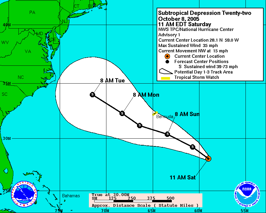
Sub-Tropical Depression Twenty-Two formed in the Atlantic this morning. Nothing amazing yet, but should become Tropical Storm Vince sometime today or tomorrow.


Sub-Tropical Depression Twenty-Two formed in the Atlantic this morning. Nothing amazing yet, but should become Tropical Storm Vince sometime today or tomorrow.