WKN Weer, Klimaat en Natuurrampen
Lees alles over het onstuimige weer op onze planeet, volg orkanen en tornado's, zie hoe vulkanen uitbarsten en hoe Moeder Aarde beeft bij een aardbeving. Alles over de verwoestende kracht van onze planeet en tal van andere natuurverschijnselen.



Ruim twee miljoen mensen in Japan moeten evacueren om orkaan Mekkhala
In Japan hebben de autoriteiten 2,2 miljoen mensen opgeroepen te evacueren vanwege orkaan Mekkhala. Het weeragentschap van het Oost-Aziatische land waarschuwt dat deze gepaard kan gaan met hevige regenbuien en windstoten tot 144 kilometer per uur. Dat kan overstromingen en aardverschuivingen tot gevolg hebben.
In verschillende regio's in het land is het op een na hoogste waarschuwingsniveau afgegeven. Ruim 200 vluchten zijn tot dusver geannuleerd. Ook zijn wegen afgesloten en werden tientallen treinen opgeschort.
De afgelopen dagen kampte het zuidwesten van Japan al met zware regenval door een storm. In Nagasaki viel in 72 uur tijd meer dan 540 millimeter regen, wat een record is. In de stad Sasebo stortte een helling in vlak bij een woonhuis, meldt omroep NHK. Daarbij raakten een schuur en auto's in de buurt beschadigd, maar de woning liep geen schade op.
Aardverschuivingen en overstromingen
De orkaan hangt nu boven de regio Okinawa en nadert de Ryukyu-eilanden in de Stille Oceaan. In Okinawa en de Amami-regio moeten mensen alert zijn op zware wind en hoge golven. In het zuiden en westen van het land is gewaarschuwd voor aardverschuivingen, overstromingen en rivieren die uit hun oevers treden.
In steden in de prefecturen Kochi en Kumamoto is al tot 64,5 millimeter regen gevallen. In de regio's Tokai, Kinki en Shikoku wordt tot 200 milimeter regen verwacht. In Nederland wordt regenval van 100 milimeter in een dag als "redelijk extreem" gezien door het KNMI.
De vrees is dat de huidige storm samensmelt met Mekkhala, waardoor ze in kracht toenemen en moeilijk voorspelbaar zijn. Het weerinstituut waarschuwt ook dat de orkaan gepaard kan gaan met tornado's en bliksem.
https://nos.nl/artikel/26(...)n-om-orkaan-mekkhala
In Japan hebben de autoriteiten 2,2 miljoen mensen opgeroepen te evacueren vanwege orkaan Mekkhala. Het weeragentschap van het Oost-Aziatische land waarschuwt dat deze gepaard kan gaan met hevige regenbuien en windstoten tot 144 kilometer per uur. Dat kan overstromingen en aardverschuivingen tot gevolg hebben.
In verschillende regio's in het land is het op een na hoogste waarschuwingsniveau afgegeven. Ruim 200 vluchten zijn tot dusver geannuleerd. Ook zijn wegen afgesloten en werden tientallen treinen opgeschort.
De afgelopen dagen kampte het zuidwesten van Japan al met zware regenval door een storm. In Nagasaki viel in 72 uur tijd meer dan 540 millimeter regen, wat een record is. In de stad Sasebo stortte een helling in vlak bij een woonhuis, meldt omroep NHK. Daarbij raakten een schuur en auto's in de buurt beschadigd, maar de woning liep geen schade op.
Aardverschuivingen en overstromingen
De orkaan hangt nu boven de regio Okinawa en nadert de Ryukyu-eilanden in de Stille Oceaan. In Okinawa en de Amami-regio moeten mensen alert zijn op zware wind en hoge golven. In het zuiden en westen van het land is gewaarschuwd voor aardverschuivingen, overstromingen en rivieren die uit hun oevers treden.
In steden in de prefecturen Kochi en Kumamoto is al tot 64,5 millimeter regen gevallen. In de regio's Tokai, Kinki en Shikoku wordt tot 200 milimeter regen verwacht. In Nederland wordt regenval van 100 milimeter in een dag als "redelijk extreem" gezien door het KNMI.
De vrees is dat de huidige storm samensmelt met Mekkhala, waardoor ze in kracht toenemen en moeilijk voorspelbaar zijn. Het weerinstituut waarschuwt ook dat de orkaan gepaard kan gaan met tornado's en bliksem.
https://nos.nl/artikel/26(...)n-om-orkaan-mekkhala
v

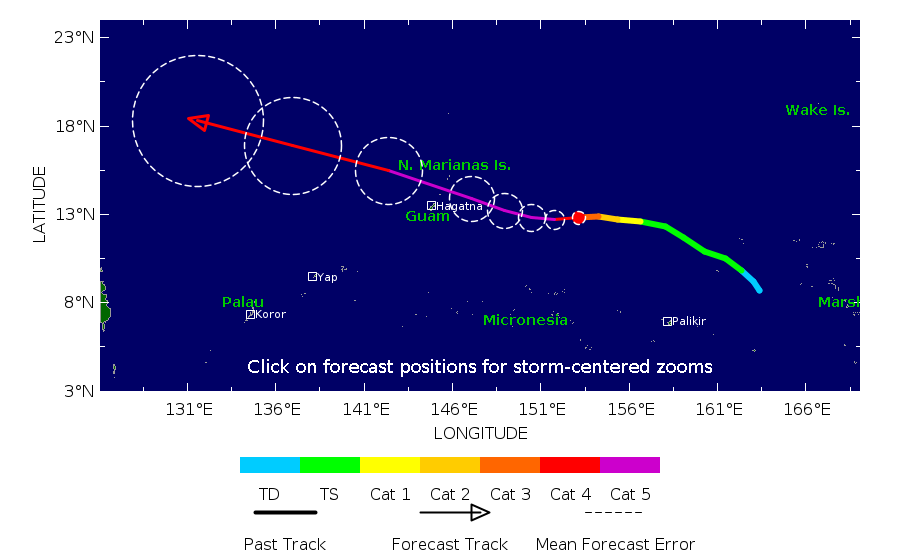
BAVI in de noordwest pacific kan wel een gevaar worden. Een aantal modellen laten een diepe kerndruk zien waarmee het een categorie 4 of 5 kan gaan worden. Taiwan ligt mogelijk in het pad.

v

wordt wel een dingetje inderdaadquote:Op donderdag 2 juli 2026 11:50 schreef 12Beaufort het volgende:
BAVI in de noordwest pacific kan wel een gevaar worden. Een aantal modellen laten een diepe kerndruk zien waarmee het een categorie 4 of 5 kan gaan worden. Taiwan ligt mogelijk in het pad.
[ afbeelding ]
https://www.vrt.be/vrtnws(...)merikaanse-eilanden/quote:Potentiële supertyfoon nadert Amerikaanse eilanden in Stille Oceaan
Emma Mertens, Belga
Gepubliceerd:
1 uur geleden
Op de Amerikaanse eilanden Guam en de Noordelijke Marianen maken inwoners zich op voor de doortocht van een weerfront dat mogelijk uitgroeit tot een supertyfoon. Daarvoor waarschuwt de Joint Typhoon Warning Center (JTWC), het gezamenlijke commando van de Amerikaanse marine en de Amerikaanse luchtmacht in Pearl Harbor.
De tyfoon, of tropische storm, nadert momenteel de Amerikaanse gebieden in de Stille Oceaan. Volgens het JTWC had tyfoon Bavi al windsnelheden van 167 kilometer per uur en windstoten tot 200 kilometer per uur. De storm hangt momenteel tussen de Marshalleilanden en de Noordelijke Marianen. Die eilanden liggen ten noordoosten van Australië.
quote:Op vrijdag 3 juli 2026 17:47 schreef zakjapannertje het volgende:
[..]
wordt wel een dingetje inderdaad
[..]
https://www.vrt.be/vrtnws(...)merikaanse-eilanden/
v
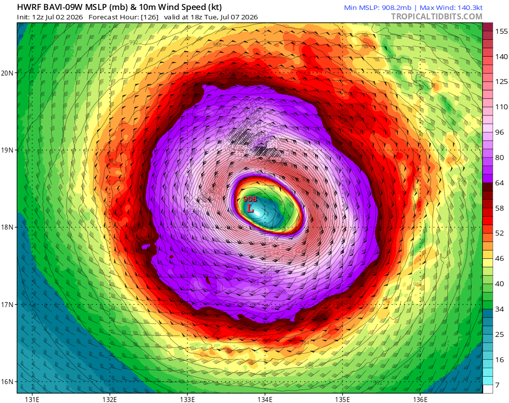
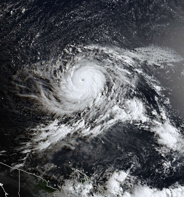
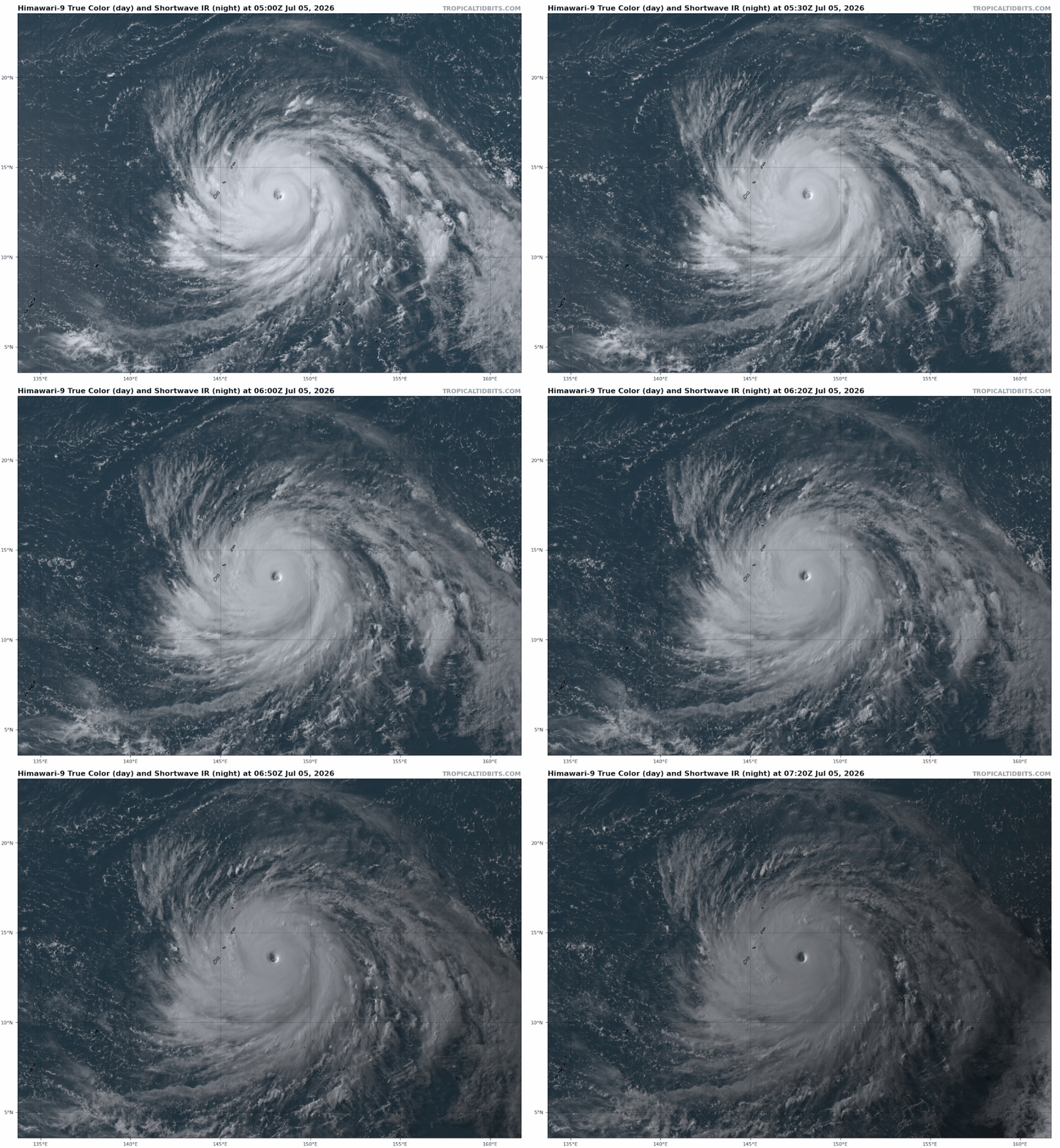


Wat een beest.
And what rough beast, its hour come round at last,
Slouches towards Bethlehem to be born?
Slouches towards Bethlehem to be born?

Een vage kennis van me zit op Rota, gelukkig alles OK nog bij hem. Flink water en eten ingeslagen vorige week, en alles dichtgetimmerd.
Bavi zou ook op China afkoersenquote:
https://nos.nl/artikel/26(...)s-gebouwen-ingestortquote:In de provincies Guangxi en Guangdong is het hoogste overstromingsalarm afgekondigd. Het water in de rivier Xijiang staat daar enorm hoog door zware regenval als gevolg van tropische storm Maysak. Gisteren vielen er daardoor al twee doden in Nanning, de hoofdstad van Guangxi. 48.000 mensen werden geëvacueerd uit die stad na een damdoorbraak.
Maysak kwam afgelopen vrijdag aan land in het zuidelijke eiland Hainan. Daarna zette de tropische storm verder koers naar het noorden van Vietnam, dat grenst aan Guangxi.
De komende dagen wordt er meer noodweer verwacht in China en de omliggende regio. De zeer sterke orkaan Bavi zou vrijdag aan land moeten komen in Taiwan, waarna hij naar verwachting zijn weg zal vervolgen richting de Chinese oostkust. Vanaf overmorgen worden er al harde windstoten en hevige regen verwacht, meldt Xinhua.

Taiwan lijkt geluk te hebben, al kan er nog wel veel regen vallen. Maar de orkaan lijkt ten noorden van het eiland te passeren. China krijgt te maken met de landfall van waarschijnlijk een categorie 3.

v


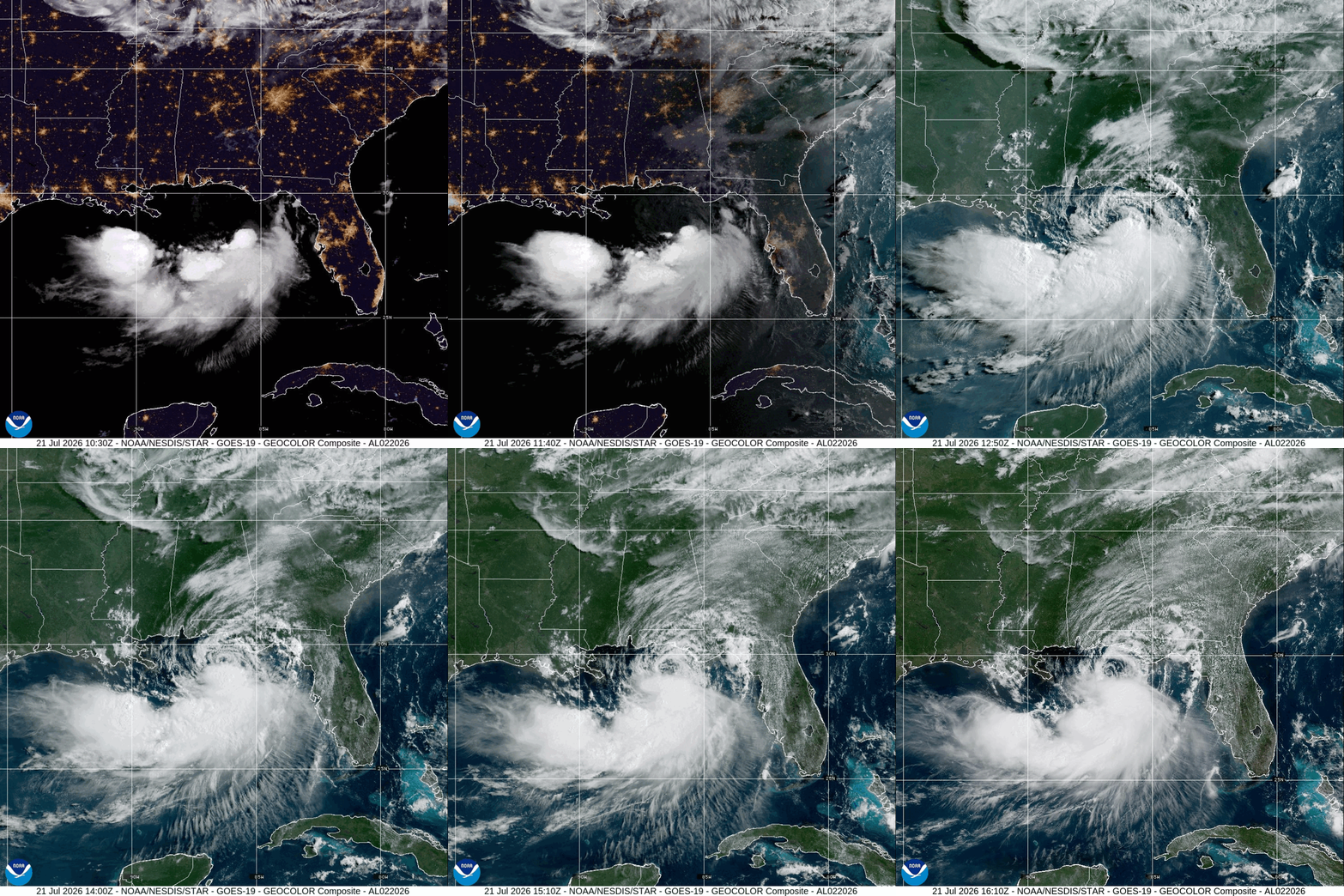
quote:Tropical Storm Bertha brings flash flood and storm surge threat from Florida to Louisiana
Tropical Storm Bertha, the second named storm of the 2026 Atlantic hurricane season, formed over the northeastern Gulf at 19:00 CDT on July 20, 2026 (00:00 UTC on July 21) and strengthened to 85 km/h (50 mph) by 06:00 UTC. A Tropical Storm Warning and Storm Surge Watch are in effect along sections of the northern Gulf Coast, where heavy rainfall, flash flooding, coastal inundation, dangerous surf, and rip currents were forecast from western Florida into southern Louisiana.
Bertha is expected to bring tropical storm conditions to portions of the Gulf Coast from Alabama westward to southeastern Louisiana Tuesday night and Wednesday, July 21 and 22, where a Tropical Storm Warning is in effect. Tropical storm conditions are possible for portions of the Florida Panhandle, Metro New Orleans, and the southern Gulf Coast of Louisiana, where a Tropical Storm Watch is in effect.
A Storm Surge Watch is in effect for the Alabama, Mississippi, and southeastern Louisiana coasts, where a life-threatening storm surge is possible.
Interests elsewhere in Louisiana and Texas should monitor the progress of this system, as additional watches or warnings could be required for portions of that area on Tuesday.
Areas of flash flooding will be possible through Thursday along the Gulf Coast and adjacent inland locations from western Florida north of Fort Myers to southern Louisiana with isolated instances of flash flooding possible westward into portions of Texas coast later in the week.
At 01:00 CDT (06:00 UTC) on July 21, Bertha’s center was located about 205 km (125 miles) south of Panama City, Florida, and 320 km (200 miles) southeast of Mobile, Alabama. The National Hurricane Center (NHC) reported that the storm was moving northwest at 4 km/h (2 mph), with a minimum central pressure of 998 hPa. Tropical-storm-force winds extended as far as 110 km (70 miles) from the center.
A Tropical Storm Warning is in effect from the Alabama–Florida border westward to the Jefferson/Plaquemines Parish border in Louisiana. Tropical-storm conditions are expected somewhere within the warning area within 36 hours.
A Tropical Storm Watch is in effect from the Bay/Gulf County line in Florida westward to the Florida–Alabama border and from west of the Jefferson/Plaquemines Parish border to Morgan City, Louisiana. The watch includes metropolitan New Orleans, Lake Pontchartrain, and Lake Maurepas. Tropical storm conditions are possible in the Florida Panhandle later on July 21 and in watched portions of Louisiana from late July 21 into July 22.
A Storm Surge Watch extends from the Alabama–Florida border to the mouth of the Mississippi River, indicating the possibility of life-threatening inundation from rising coastal water within 48 hours. The NHC said additional watches or warnings could be required later on July 21.
Peak water levels of 0.6–1.2 m (2–4 feet) above normally dry ground are forecast from the mouth of the Mississippi River to the Alabama–Florida border if the surge coincided with high tide. Levels of 0.3–0.9 m (1–3 feet) were forecast from Morgan City to the mouth of the Mississippi River, in Lake Pontchartrain, and along the Florida coast from Indian Pass to Chassahowitzka.

21 Jul 2026 - 15:00 UTC ...AIR FORCE HURRICANE HUNTERS FIND BERTHA HAS STRENGTHENED... ...TROPICAL STORM WATCHES AND WARNINGS REMAIN IN EFFECT FOR PORTIONS OF THE NORTHERN GULF COAST... As of 10:00 AM CDT Tue Jul 21 the center of Bertha was located near 29.3, -86.3 with movement NNW at 3 mph. The minimum central pressure was 995 mb with maximum sustained winds of about 60 mph.
v
|
|
