WKN Weer, Klimaat en Natuurrampen
Lees alles over het onstuimige weer op onze planeet, volg orkanen en tornado's, zie hoe vulkanen uitbarsten en hoe Moeder Aarde beeft bij een aardbeving. Alles over de verwoestende kracht van onze planeet en tal van andere natuurverschijnselen.


Naarmate Erin dichter bij de oostkust komt, zal hij in steeds warmer water terecht komen. Dit zal er voor zorgen dat de orkaan in kracht zal toenemen.
De Leeward eilanden en Puerto Rico kunnen nog wel de nodige overlast krijgen van deze orkaan, daarna laten de meeste modellen hem afbuigen richting het noorden.
De Leeward eilanden en Puerto Rico kunnen nog wel de nodige overlast krijgen van deze orkaan, daarna laten de meeste modellen hem afbuigen richting het noorden.

v

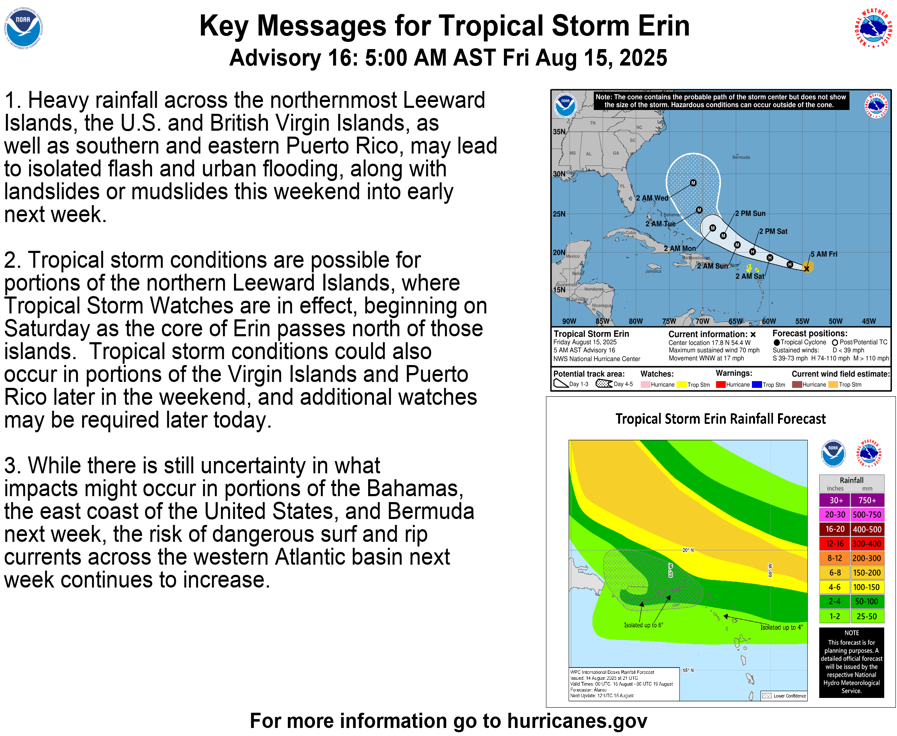
Erin heeft nu een kerndruk van 997mb en een windsnelheid van 70 mile (112 km). Daarmee is het bijna een categorie 1 orkaan.
v
De eerste orkaan van dit seizoen is een feit...
quote:...ERIN BECOMES THE FIRST HURRICANE OF THE 2025 SEASON...
...EXPECTED TO PASS NEAR OR NORTH OF THE LEEWARD ISLANDS ON
SATURDAY...
SUMMARY OF 1100 AM AST...1500 UTC...INFORMATION
-----------------------------------------------
LOCATION...18.2N 56.1W
ABOUT 460 MI...740 KM E OF THE NORTHERN LEEWARD ISLANDS
MAXIMUM SUSTAINED WINDS...75 MPH...120 KM/H
PRESENT MOVEMENT...WNW OR 290 DEGREES AT 18 MPH...30 KM/H
MINIMUM CENTRAL PRESSURE...996 MB...29.42 INCHES
WATCHES AND WARNINGS
--------------------
CHANGES WITH THIS ADVISORY:
None.
SUMMARY OF WATCHES AND WARNINGS IN EFFECT:
A Tropical Storm Watch is in effect for...
* Anguilla and Barbuda
* St. Martin and St. Barthelemy
* Saba and St. Eustatius
* Sint Maarten
v

Jammer dat de helft niks doet.quote:Op vrijdag 15 augustus 2025 17:32 schreef 12Beaufort het volgende:
Aantal webcams.
https://meteo-sbh.com/?page=webcams_anim
Doe mee met het voorspellen van het weer!
Weekvoorspelling | Week 39 (Inschrijven tot 22-9, 11:59)
Maandvoorspelling | September (Gesloten)
Jaarvoorspelling 2024 / 2025
Weekvoorspelling | Week 39 (Inschrijven tot 22-9, 11:59)
Maandvoorspelling | September (Gesloten)
Jaarvoorspelling 2024 / 2025
Kloptquote:
[..]
Duurt even. Vanmiddag deden ze het allemaal.
De eerste blijft na paar seconden hangen, de 2de knalt een turbo in en ook die blijft daarna hangen
De laatste camera doet het wel, alleen de palmbomen staan in de weg
Maar goed we gaan het kijken, een alles vernietigende orkaan krijgen ze daar niet, het weerstation zal wel blijven hangen
Doe mee met het voorspellen van het weer!
Weekvoorspelling | Week 39 (Inschrijven tot 22-9, 11:59)
Maandvoorspelling | September (Gesloten)
Jaarvoorspelling 2024 / 2025
Weekvoorspelling | Week 39 (Inschrijven tot 22-9, 11:59)
Maandvoorspelling | September (Gesloten)
Jaarvoorspelling 2024 / 2025
Die fish eye snap ik ook nietquote:Op vrijdag 15 augustus 2025 20:17 schreef SpeedyGJ het volgende:
[..]
Klopt
De eerste blijft na paar seconden hangen, de 2de knalt een turbo in en ook die blijft daarna hangende fish eye, leuk concept wel maar echt niet nuttig

De laatste camera doet het wel, alleen de palmbomen staan in de weg
Maar goed we gaan het kijken, een alles vernietigende orkaan krijgen ze daar niet, het weerstation zal wel blijven hangen
v
Ineens zijn er 9 camera's toegevoegdquote:
Jammer dat diegene de inactieve camera's er niet uitlaat
Doe mee met het voorspellen van het weer!
Weekvoorspelling | Week 39 (Inschrijven tot 22-9, 11:59)
Maandvoorspelling | September (Gesloten)
Jaarvoorspelling 2024 / 2025
Weekvoorspelling | Week 39 (Inschrijven tot 22-9, 11:59)
Maandvoorspelling | September (Gesloten)
Jaarvoorspelling 2024 / 2025
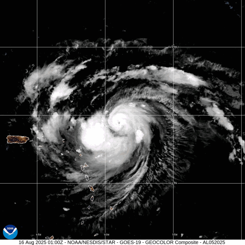
Erin is nu een categorie 2 orkaan met een kerndruk van 971 mb en een windveld van 160 km met nog hogere windstoten. Er is nu duidelijk een oog zichtbaar.
De orkaan komt nu in nog warmer water en zal in grootte en in kracht verder toenemen.
De orkaan komt nu in nog warmer water en zal in grootte en in kracht verder toenemen.
v
Erin is snel in kracht aan het toenemen en is nu een 'Major Hurricane' (categorie 3). De kerndruk is gedaald naar 955 mb en het windveld is toegenomen tot bijna 200 km.
quote:16 Aug 2025 - 9:00 UTC ...ERIN RAPIDLY STRENGTHENING... ...OUTER RAINBANDS BEGINNING TO AFFECT THE NORTHERN LEEWARD ISLANDS... As of 5:00 AM AST Sat Aug 16 the center of Erin was located near 19.8, -61.1 with movement WNW at 20 mph. The minimum central pressure was 955 mb with maximum sustained winds of about 120 mph.
v
Categorie 4 nu. Windsnelheid net boven de 200 km.
Tropische storm waarschuwing voor een aantal eilandjes net ten noorden van Haïti
Tropische storm waarschuwing voor een aantal eilandjes net ten noorden van Haïti
quote:17 Aug 2025 - 6:00 UTC ...ERIN'S OUTER RAINBANDS PRODUCING GUSTY WINDS AND HEAVY RAINS ACROSS THE VIRGIN ISLANDS AND PUERTO RICO... As of 2:00 AM AST Sun Aug 17 the center of Erin was located near 20.4, -66.1 with movement WNW at 14 mph. The minimum central pressure was 940 mb with maximum sustained winds of about 125 mph.
v
En de volgende wave ziet er ook al indrukwekkend uit. Deze verlaat Afrika net als Erin met al een draaiing zichtbaar. Het is te hopen dat Kaap Verdie deze keer gespaard wordt.
Op lange termijn laat deze een zuidelijker koers zien dan Erin.
Op lange termijn laat deze een zuidelijker koers zien dan Erin.
v
Full hit in noorden van Florida volgens lange termijn verwachting.quote:
En de volgende wave ziet er ook al indrukwekkend uit. Deze verlaat Afrika net als Erin met al een draaiing zichtbaar. Het is te hopen dat Kaap Verdie deze keer gespaard wordt.
Op lange termijn laat deze een zuidelijker koers zien dan Erin.
[ afbeelding ]
Doe mee met het voorspellen van het weer!
Weekvoorspelling | Week 39 (Inschrijven tot 22-9, 11:59)
Maandvoorspelling | September (Gesloten)
Jaarvoorspelling 2024 / 2025
Weekvoorspelling | Week 39 (Inschrijven tot 22-9, 11:59)
Maandvoorspelling | September (Gesloten)
Jaarvoorspelling 2024 / 2025
Die kan Florida wel eens gaan raken...quote:
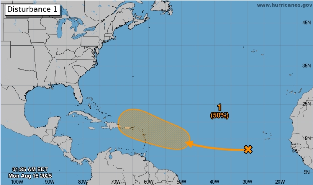
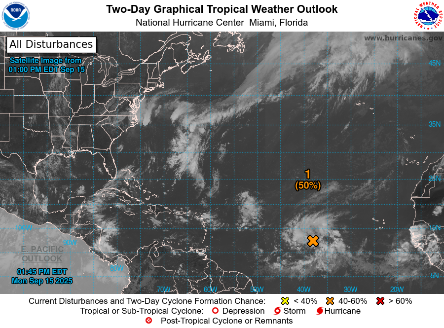
50% kans op de vorming van een tropisch systeem.
[ afbeelding ]


quote:Odds increase for more tropical development after Erin
A disturbance in the Atlantic Ocean’s Main Development Region has a medium chance of developing into a tropical cyclone within the next seven days. If the system develops into a tropical storm, it will be named Fernand, the next designation on the 2025 Atlantic hurricane list.
The system consists of disorganized thunderstorms and is moving west to west-northwest at about 32 km/h (20 mph). Forecasts indicate it could approach the Leeward Islands by August 22.
The Main Development Region currently provides favorable conditions for cyclogenesis, including warm sea surface temperatures, abundant mid-level moisture, and relatively low vertical wind shear. However, the NHC noted that additional organization of the disturbance is required before issuing a more reliable forecast.
Computer models show limited agreement on the future trajectory. Some indicate a potential northward turn behind Hurricane Erin, while others suggest a continued westward movement toward the islands. If the system develops into a tropical storm, it will be named Fernand, the next designation on the 2025 Atlantic hurricane list.
The disturbance follows Hurricane Erin, which became the first major hurricane of the 2025 season. Erin formed near the Cabo Verde Islands on August 11 and rapidly intensified, reaching Category 5 on August 16. The storm later weakened and fluctuated between Category 3 and Category 4 while remaining offshore.
Erin generated life-threatening surf and rip currents along the U.S. East Coast, prompting states of emergency and evacuations in parts of North Carolina.
At present, the newly identified disturbance does not pose an immediate threat to land, and no watches or warnings are in effect. Residents of the Leeward Islands are advised to monitor forecasts closely as the system evolves later this week.
Erin is enorm in omvang aan het groeien. De kerndruk is nu 958 mb. De verwachting is dat de de orkaan in omvang nog verder zal toenemen.

v
Ook leuk om te zien, een meetboei op zee waar het orkaan nadert, waarschijnlijk gaat deze net langs de boei.
Leuk om te zien dat je alle parameters kunt bekijken en die zelfs een camera die om de 10min een foto maakt
Hier te bekijken
Leuk om te zien dat je alle parameters kunt bekijken en die zelfs een camera die om de 10min een foto maakt
Hier te bekijken
Doe mee met het voorspellen van het weer!
Weekvoorspelling | Week 39 (Inschrijven tot 22-9, 11:59)
Maandvoorspelling | September (Gesloten)
Jaarvoorspelling 2024 / 2025
Weekvoorspelling | Week 39 (Inschrijven tot 22-9, 11:59)
Maandvoorspelling | September (Gesloten)
Jaarvoorspelling 2024 / 2025
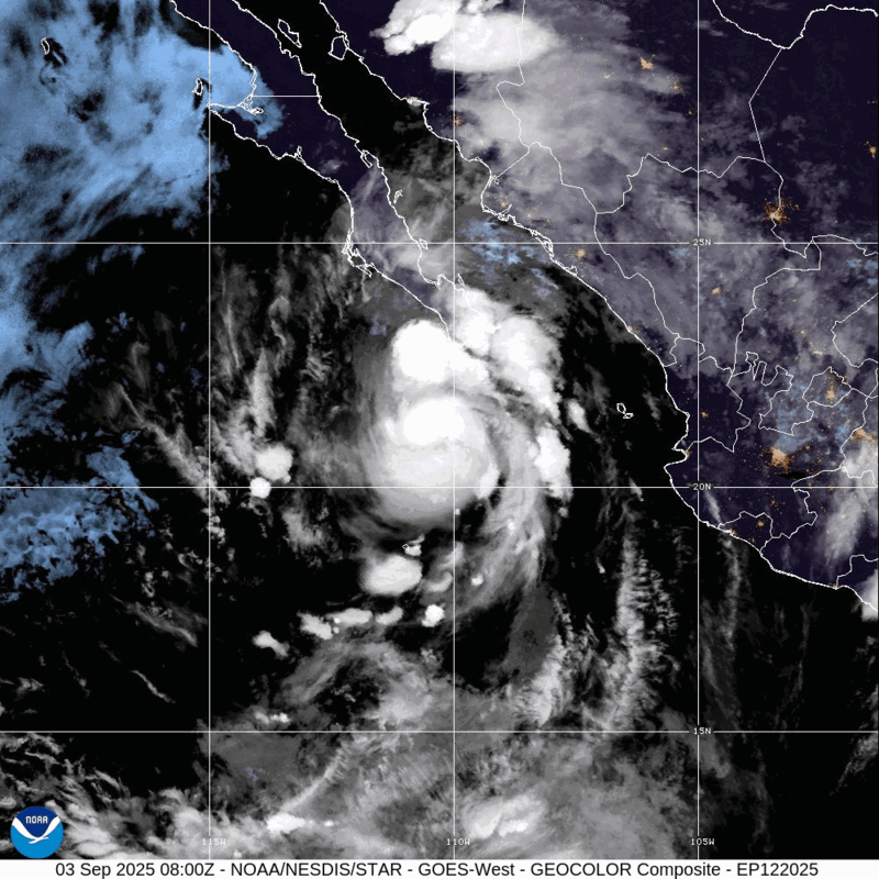
Dit gaat voor veel overlast zorgen in het uiterste zuiden van China (Hainan) en daarna is Vietnam aan de beurt.

v


Kiko heeft een kerndruk van 946 mb en is daarmee een categorie 4 orkaan. Dit systeem ligt nu nog op zo'n 1600 kilometer van Hawai en zal dit eiland aan de noordkant passeren. Waarschijnlijk zal het eiland overlast krijgen van hoge golven en mogelijk veel neerslag door uitlopers van neerslagbanden.

v
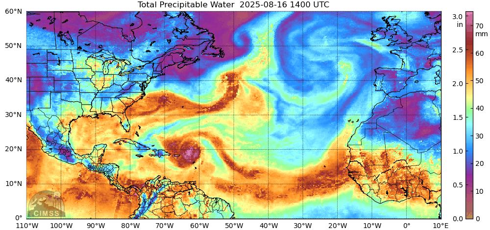
Voor het tweede jaar op rij is het opmerkelijk stil in de Atlantische Oceaan. Waar op 10 september normaal gesproken de piek van het orkaanseizoen valt, is het dit jaar erg rustig in de Atlantische Oceaan, met geen orkaan in zicht. Wat is er aan de hand en wat betekent dit voor de rest van het orkaanseizoen?
Waarom is het zo rustig?
De rust wordt voornamelijk veroorzaakt doordat het op grote hoogte hard waait. Dit noemen we in meteorologische termen ook wel windschering: het verschil in windsnelheid tussen het oppervlak en op grote hoogte. Orkanen kunnen doorgaans alleen vormen in een omgeving met weinig windschering. Wanneer er meer windschering is, wordt de orkaan kapot geblazen.
Dat er nu zo veel windschering is, is opmerkelijk; in deze periode is er meestal juist weinig windschering boven de Atlantische oceaan is. De rode gebieden in Figuur 1 zijn gebieden waar op dit moment meer windschering is dan normaal; de omcirkelde gebieden zijn gebieden in deze periode van het orkaanseizoen orkanen zouden kunnen vormen. Maar wat we zien is dat precies in die gebieden er nu juist veel windschering is, waardoor stormen moeite hebben om door te groeien tot orkanen.
Naast de windschering zorgt ook droge lucht ervoor dat stormen moeite hebben om door te groeien tot orkanen. Orkanen hebben vochtige, warme lucht nodig om te kunnen ontstaan en door te groeien, omdat ze uit deze lucht hun energie halen. Maar wanneer droge lucht, bijvoorbeeld van de Sahara, in de orkaan terechtkomt, kan die ervoor zorgen dat de orkaan als het ware 'stikt'. De orkaan wordt dan afgesneden van de toevoer van warme, vochtige lucht en zwakt daardoor af, soms zelfs tot het punt dat de orkaan helemaal verdwijnt. Dit zagen we bijvoorbeeld afgelopen weekend gebeuren, toen een groep onweersbuien ontsnapt was aan de windschering en probeerde door te groeien tot een orkaan, maar vervolgens te maken kreeg met een hoop droge Sahara-lucht en daardoor uitdoofde.
lees hier verder
v
De orkaantrein lijkt weer op gang te komen. 50% nu boven de Atlantische oceaan. Achter dit systeeem lijken nog meerdere gebieden te ontstaan.
v

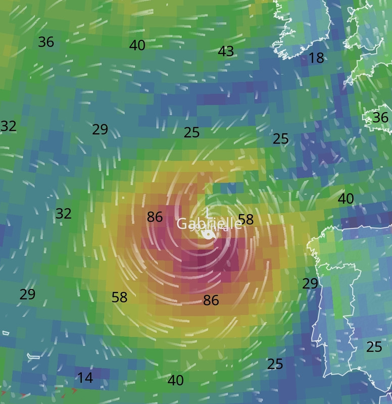
Tropische depressie Seven. Deze zal binnenkort de naam Gabrielle krijgen en trekt, in kracht toenemend, in de richting van Bermuda.

v
Inmiddels is Gabrielle ontstaan boven de Atlantische oceaan. De meeste modellen laten haar op ruime afstand langs Bermuda trekken. EC zit nog het het meest dichtbij het eiland. Over een aantal dagen zal er meer duidelijkheid zijn over hoe dicht de orkaan langs Bermuda zal gaan.
v
Een zeer gevaarlijke tyfoon (categorie 5) ligt momenteel net ten oosten van de Filipijnen en trekt noord van dit eiland langs. De kerndruk is nu 911 mb. Het windveld zit rond de 270 km/u met windstoten boven de 300 km. De tyfoon heeft de naam Ragasa gekregen en kan in het noorden van de Filippijnen en het zuiden van Taiwan voor veel overlast gaan zorgen.

v
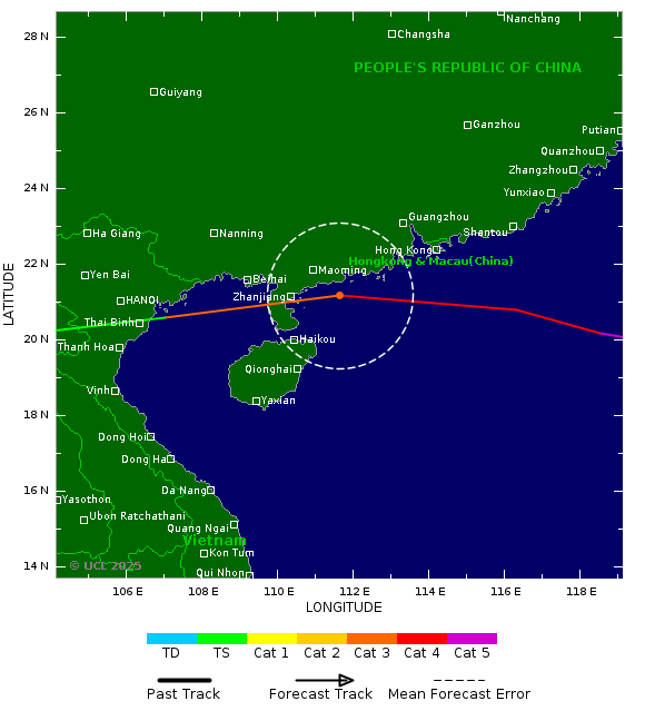
De tyfoon trekt daarna verder richting China, waar het (als een categorie 4) zuid van Hong Kong langs trekt.
v
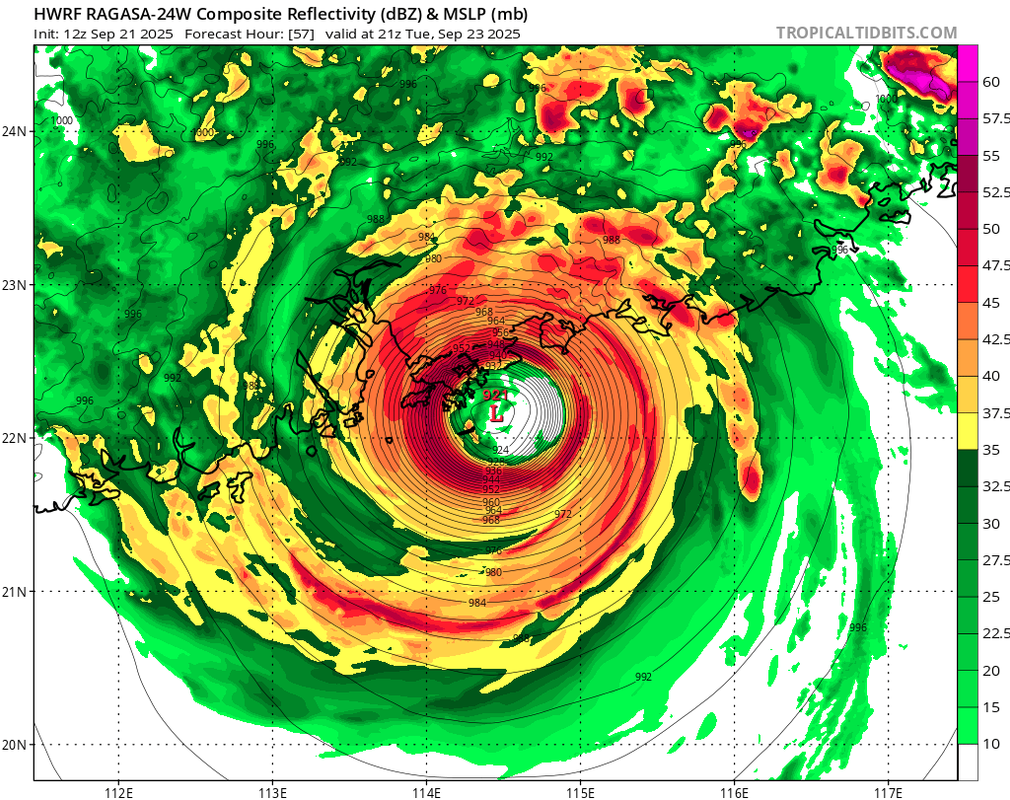
De druk is nog iets gedaald en zit nu op 910 mb. De tyfoon ligt nu net ten noorden van de Filippijnen.

v

Wat een beestquote:
De druk is nog iets gedaald en zit nu op 910 mb. De tyfoon ligt nu net ten noorden van de Filippijnen.
[ afbeelding ]
Op maandag 9 oktober 2023 13:31 schreef Nova het volgende:[/b]
Oh schatje, wat lief van je om dat te zeggen! Jij bent echt een prins op het witte paard voor mij. Met jou voel ik me zo geliefd en speciaal. Laten we nog lang samen genieten van sprookjesachtige avonturen en elkaar verwennen met veel knuffels en kusjes. O+ naar jou, mijn lieve prins! :*
Oh schatje, wat lief van je om dat te zeggen! Jij bent echt een prins op het witte paard voor mij. Met jou voel ik me zo geliefd en speciaal. Laten we nog lang samen genieten van sprookjesachtige avonturen en elkaar verwennen met veel knuffels en kusjes. O+ naar jou, mijn lieve prins! :*
|
|