WKN Weer, Klimaat en Natuurrampen
Lees alles over het onstuimige weer op onze planeet, volg orkanen en tornado's, zie hoe vulkanen uitbarsten en hoe Moeder Aarde beeft bij een aardbeving. Alles over de verwoestende kracht van onze planeet en tal van andere natuurverschijnselen.


Winter op het zuidelijk halfrond 2024
Het is zomer op het noordelijk halfrond, maar op het zuidelijk halfrond is inmiddels de winter van start gegaan. Ook hier kan de winter hard toeslaan, al is dat minder hard dan op het noordelijk halfrond. Het verschil zit vooral in de open zee die tussen Antarctica en het vaste land zit, hierdoor warmt de kou meer op omdat deze over nog 'warm' water zijn weg richting land zal moeten vinden. Vooral het zuidelijk deel van Argentinie, Chili en New Zeeland krijgen elk jaar te maken met winterweer, maar ook in het zuiden van Australie kan de winter van zich laten horen.
De weerrecords.
Opzich niet heel indrukkwekkend. Zelfs in Nederland is het kouder geweest dan in heel Oceanië.
-Zuid-Amerika: -39,0°C in Valle de Los Patos Superior, San Juan, Argentinië
-Oceanië: -25,6°C in Ranfurly, Nieuw-Zeeland
-De laagste temperatuur ooit in Australië gemeten was -23,0 graden op 28 juni 1994 in Charlotte Pass (New South Wales). Deze locatie in de Snowy Mountains ligt op 1727 meter hoogte en is doorgaans een koude plek. Ook in de zomer vriest het hier soms. Tasmanië noteerde op 30 juni 1983 minima van 13 graden onder nul. De temperatuur van het zeewater varieert zomers van 25 graden in Brisbane tot 15 graden in Tasmanië.
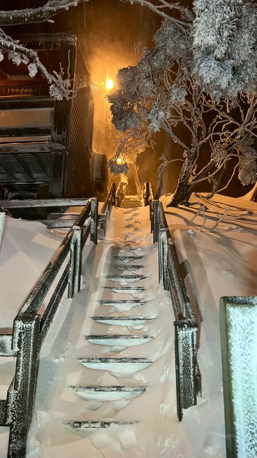
Hier onder nog wat foto's uit het topic van vorig jaar, wat hier te vinden is.
De bedoeling van dit topic is om het nieuws over de winter op het zuidelijk halfrond bij te houden.
Voor het het nieuws over het ijs op Antarctica is er dit topic: WKN / Poolkappen, IJsbergen en Gletsjers #5
Het is zomer op het noordelijk halfrond, maar op het zuidelijk halfrond is inmiddels de winter van start gegaan. Ook hier kan de winter hard toeslaan, al is dat minder hard dan op het noordelijk halfrond. Het verschil zit vooral in de open zee die tussen Antarctica en het vaste land zit, hierdoor warmt de kou meer op omdat deze over nog 'warm' water zijn weg richting land zal moeten vinden. Vooral het zuidelijk deel van Argentinie, Chili en New Zeeland krijgen elk jaar te maken met winterweer, maar ook in het zuiden van Australie kan de winter van zich laten horen.
De weerrecords.
Opzich niet heel indrukkwekkend. Zelfs in Nederland is het kouder geweest dan in heel Oceanië.
-Zuid-Amerika: -39,0°C in Valle de Los Patos Superior, San Juan, Argentinië
-Oceanië: -25,6°C in Ranfurly, Nieuw-Zeeland
-De laagste temperatuur ooit in Australië gemeten was -23,0 graden op 28 juni 1994 in Charlotte Pass (New South Wales). Deze locatie in de Snowy Mountains ligt op 1727 meter hoogte en is doorgaans een koude plek. Ook in de zomer vriest het hier soms. Tasmanië noteerde op 30 juni 1983 minima van 13 graden onder nul. De temperatuur van het zeewater varieert zomers van 25 graden in Brisbane tot 15 graden in Tasmanië.
Hier onder nog wat foto's uit het topic van vorig jaar, wat hier te vinden is.


De bedoeling van dit topic is om het nieuws over de winter op het zuidelijk halfrond bij te houden.
Voor het het nieuws over het ijs op Antarctica is er dit topic: WKN / Poolkappen, IJsbergen en Gletsjers #5

Het koudst is het momenteel in Argentinië. Waar het tot ver in het noorden onder nul komt en er ook sneeuw is gevallen. De komende dagen lijkt er meer sneeuw te gaan vallen.

quote:In gebieden zoals Potrerillos, El Salto, Las Vegas, Las Cuevas, Puente del Inca, Punta de Vacas en Uspallata heeft het gesneeuwd, terwijl er in het Grote Mendoza constant regenval is geweest. Vanwege het slechte weer zijn de lessen op sommige van deze plaatsen opgeschort.
Als reactie op deze situatie heeft de Civiele Bescherming waarschuwingen uitgegeven voor de departementen Malargüe, San Rafael, Tunuyán, Tupungato en San Carlos. Ze adviseren om extra voorzichtig te zijn bij het reizen over wegen en paden vanwege de slechte weersomstandigheden.


Vertaald uit het Portugees. https://news.google.com/a(...)=AR&ceid=AR%3Aes-419quote:Als gevolg van de sneeuwval wordt de doorgang naar Chili morgen uit voorzorg gesloten. De afsluiting begint om 00:00 uur Argentijnse tijd en 23:00 uur Chileense tijd.
"Overeenkomstig de afspraken tussen beide coördinaties zal de doorgang bij Uspallata en Guardia Vieja worden gesloten," meldde de instantie.
De preventieve sluiting is het gevolg van de instabiele omstandigheden in het hooggebergte, zoals voorspeld door verschillende weersmodellen, die de veilige doorgang zouden beïnvloeden.
Even vertaald door AI.
quote:De Pehuenchepas in Malargüe zal deze zondag preventief vanaf 15.00 uur gesloten zijn, waardoor reizen niet mogelijk is. Deze maatregel geldt voor alle soorten voertuigen.
Het besluit van de coördinatoren van beide landen is gebaseerd op de voorspelling van slecht weer deze zondagmiddag. In Chili wordt de maatregel vanaf 14.00 uur ingevoerd, omdat het daar een uur eerder is.
"De verschillende meteorologische modellen verwachten overvloedige sneeuwval en sterke wind, met een grotere intensiteit in het berggebied van Chili, wat een veilige doorgang zal verhinderen," aldus Justo Báscolo, de coördinator van de pas in Argentinië.
https://mediamendoza.com/(...)enche-desde-que-hora
quote:De Nationale Weerdienst (SMN), onderdeel van het Ministerie van Defensie, heeft een code oranje uitgegeven voor sneeuwval in verschillende gebieden van Argentinië, waaronder het gebergte van Neuquén en Mendoza.
Aanstaande zaterdag wordt de koudste dag van het jaar, waarbij het (misschien) tot sneeuw kan komen in Buenos Aires.
Er komen een aantal koudere dagen aan voor het zuiden van Argentinië. Strenge vorst met ook kans op sneeuw.


Even vertaald. Er staan nogal wat vrachtwagens vast voor een gesloten bergpas.
quote:Om de problemen aan te pakken van vrachtwagenchauffeurs die dagenlang moeten wachten op de heropening van de Internationale Pas vanwege zware weersomstandigheden, heeft de regering van Mendoza, in samenwerking met de Algemene Coördinatie en Beheer van de Grenscentra van het Systeem van de Internationale Pas Cristo Redentor, het Noodprotocol voor Langdurige Sluitingen van de internationale corridor ingevoerd. Dit protocol omvat een ambulance, medisch personeel en hulp in het Chrabalowski-ziekenhuis voor chauffeurs die dat nodig hebben.
"We hebben drie opvangplekken in het hooggebergte. Eén bevindt zich bij het ACI waar de douane is, een andere naast het YPF-station in Uspallata, en een derde in Doña Carmen. Deze drie opvangplekken kunnen samen negenhonderdtachtig vrachtwagens herbergen," verklaarde de onderminister van Industrie, Handel en Logistiek, Alberto Marengo. Hij voegde eraan toe dat "tot nu toe alleen de opvangplek bij het ACI volledig bezet is."
https://www.mdzol.com/soc(...)rdillera-429534.html


De grensovergang tussen Argentinië en Chili is nog steeds gesloten vanwege de sneeuw. Er lijkt de komende dagen nog meer sneeuw bij te komen.
Ook in het zuiden van Nieuw Zeeland is het winterweer.
quote:A polar jet stream is set to bring a chill across most of the country in coming days, including more snow for the South.
Crown agency Niwa said autumn "is ending as it started - with below-average temperatures".
It said a southerly change would usher in colder air over the weekend, which "will begin a period of gusty, brisk wind for parts of the country, making it feel even colder".
"Sunday looks to have a wind chill across most of the country which may be reinforced toward the middle part of next week."

Koude nacht in het zuiden van Nieuw Zeeland. Met wat sneeuw.
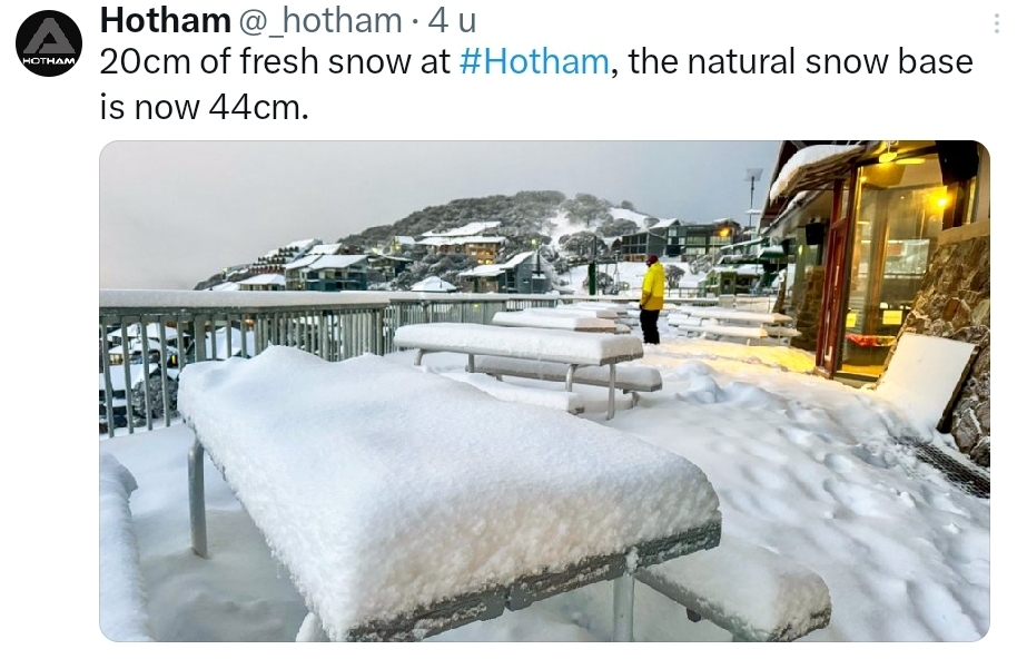
A chilly -3°C at #Hotham tonight. #Snow flurries continuing! ❄️❄️
https://x.com/_hotham/sta(...)fo7CtdNTQlwtVxQ&s=19
[ Bericht 6% gewijzigd door #ANONIEM op 02-06-2024 13:50:23 ]
A chilly -3°C at #Hotham tonight. #Snow flurries continuing! ❄️❄️
https://x.com/_hotham/sta(...)fo7CtdNTQlwtVxQ&s=19
[ Bericht 6% gewijzigd door #ANONIEM op 02-06-2024 13:50:23 ]
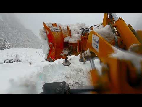
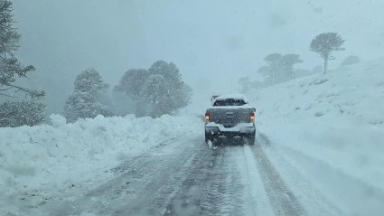
Ook sneeuw in de hogere delen van Argentinië.
De Argentijnse 'Rijkswaterstaat' heeft daar zaterdag aanbevolen extra voorzichtig te zijn op de nationale route 40 tussen Bariloche en El Bolsón vanwege sneeuw op de weg en het verlies van grip voor voertuigen.
In het algemeen sneeuwt het op de hogere delen van de route, waar veegmachines bezig zijn met het vrijmaken van de weg.
Het wordt aanbevolen om sneeuwkettingen mee te nemen.
free plaatjes
https://www.bariloche2000(...)a-a-el-bolson/153833
De Argentijnse 'Rijkswaterstaat' heeft daar zaterdag aanbevolen extra voorzichtig te zijn op de nationale route 40 tussen Bariloche en El Bolsón vanwege sneeuw op de weg en het verlies van grip voor voertuigen.
In het algemeen sneeuwt het op de hogere delen van de route, waar veegmachines bezig zijn met het vrijmaken van de weg.
Het wordt aanbevolen om sneeuwkettingen mee te nemen.


free plaatjes
https://www.bariloche2000(...)a-a-el-bolson/153833
Nieuw Zeeland verwacht een warmere winter dan normaal. Met het huidige klimaat is dat ook niet verwonderlijk. Grootste kans op winter is uiteraard voor het zuiden van het eiland...
quote:De wintertemperaturen zijn in het hele land ongeveer even waarschijnlijk rond het gemiddelde als boven het gemiddelde. Er wordt een periode van warmer dan gemiddelde temperaturen verwacht in de eerste helft van juni, gevolgd door een terugkeer naar meer typische omstandigheden in de tweede helft van de maand. Hoewel er gedurende het seizoen af en toe koudegolfjes worden verwacht, zullen deze waarschijnlijk van korte duur zijn.
https://niwa.co.nz/climat(...)ook-june-august-2024

De eerste sneeuw voor zuid Afrika. Tijdens noodweer zijn hier meerdere doden gevallen. Mede door tornado's.
https://www.facebook.com/(...)ype=3&ref=embed_post
quote:In the past 24 hours, South Africa has witnessed at least two tornadoes north of Durban, hail in Umhlanga, snow in the Northern Cape and heavy rains and strong winds in the Western and Eastern Cape. So far, seven people have lost their lives in Eastern Cape and at least five people were confirmed killed in KwaZulu-Natal on monday
Winter is setting in as severe weather batters parts of the country. More cold, wet and windy conditions are expected throughout this week, with snow falling in some areas.
Downed trees and destroyed homes were reported in the Tongaat area north of Durban on Monday afternoon after tornadoes tore through the area.
https://www.dailymaverick(...)d-high-winds-hit-sa/

https://www.facebook.com/(...)ype=3&ref=embed_post
Sneeuwkettingen verplicht tijdens het nemen van deze bergpas in Argentinië.
https://x.com/PasoCRMza/s(...)fCnk9nCXXXIQi4w&s=19
[ Bericht 33% gewijzigd door #ANONIEM op 06-06-2024 18:06:53 ]
https://x.com/PasoCRMza/s(...)fCnk9nCXXXIQi4w&s=19

[ Bericht 33% gewijzigd door #ANONIEM op 06-06-2024 18:06:53 ]
Volgens een klimaatsamenvatting van NIWA heeft een hoger dan gemiddeld aantal zuidwestenwinden ervoor gezorgd dat Nieuw-Zeeland in mei 2024 de koudste mei beleefde sinds 2009.
De gemiddelde temperatuur in het hele land was in mei 2024 9,8°C, met de laagste temperatuur van -9,7°C, gemeten op 10 mei in Cass.
De hoogste temperatuur was 23,4°C, gemeten op 6 mei in Whakatu.
Ongeveer 35% van de weerstations in het land noteerde gemiddelde temperaturen die minstens 2°C onder het gemiddelde lagen. Vorst kwam regelmatig voor in de binnenlandse gebieden.
[ Bericht 37% gewijzigd door #ANONIEM op 07-06-2024 18:08:10 ]
De gemiddelde temperatuur in het hele land was in mei 2024 9,8°C, met de laagste temperatuur van -9,7°C, gemeten op 10 mei in Cass.
De hoogste temperatuur was 23,4°C, gemeten op 6 mei in Whakatu.
Ongeveer 35% van de weerstations in het land noteerde gemiddelde temperaturen die minstens 2°C onder het gemiddelde lagen. Vorst kwam regelmatig voor in de binnenlandse gebieden.
quote:Christchurch and Timaru recorded their lowest ever average minimum temperatures for May, with averages of 0.5°C and 0°C respectively.
Rainfall was below or well below normal for most of the South Island, Bay of Plenty, and parts of Waikato and Northland, but above or well above normal for isolated parts of Auckland, Gisborne, Hawke's Bay, and southern Wairarapa.
The highest one-day rainfall was 130mm recorded at Leigh, north of Auckland, on May 20.
The highest wind gust of 152 km/h was detected at Secretary Island near Doubtful Sound on May 29.
Warm in Auckland, wet in the capital
Of the main centres, Auckland was the warmest, Tauranga was the sunniest, Dunedin was the driest and least sunny, Christchurch was the coolest, and Wellington was the wettest.
Of the available sunshine observation sites, the sunniest four locations in 2024 were Marlborough with 1265 hours, Nelson with 1251 hours, Bay of Plenty with 1220 hours and Taranaki with 1218 hours.
https://www.1news.co.nz/2(...)ay-in-15-years-niwa/
[ Bericht 37% gewijzigd door #ANONIEM op 07-06-2024 18:08:10 ]
Argentinië
De Nationale Meteorologische Dienst (SMN) heeft opnieuw een waarschuwing voor sneeuwval uitgegeven voor de bergketen van Neuquén, dit keer voor aanstaande zaterdag. De waarschuwing, van geel niveau, komt na de onzekerheid rondom een storm in Chili, die ook sommige delen van de provincie deze woensdag trof. Bovendien worden er zware stormen verwacht in Río Negro (Argentinië).
[ Bericht 17% gewijzigd door #ANONIEM op 07-06-2024 18:22:18 ]
De Cristo Redentor Pass is weer gesloten voor verkeer. Door de sneeuw is het gevaar op eventuele lawines groot. Ook vandaag is hier weer sneeuw gevallen.
[ Bericht 0% gewijzigd door #ANONIEM op 17-06-2024 23:24:22 ]
[ Bericht 0% gewijzigd door #ANONIEM op 17-06-2024 23:24:22 ]
Het is een zeer goede start van het seizoen 2024 voor het skigebied Los Puquios, bij de stad Mendoza. Inmiddels ligt er meer dan een meter sneeuw. Na het prepareren van de pistes blijft hier zo'n 60 centimeter van over.
De komende dagen komt er nog meer sneeuw bij.
https://news.google.com/a(...)=AR&ceid=AR%3Aes-419
De komende dagen komt er nog meer sneeuw bij.

https://news.google.com/a(...)=AR&ceid=AR%3Aes-419
Kouderecords voor de maand juni in Australië.
quote:Several other places have also experienced their coldest temperature in more than 10 years during this event.
Some of the highlights include:
Longerenong, Victoria. Maximum of 7.9C on Friday 14th June — coldest day in 27 years
Nhill, Victoria. Maximum of 8.3C on Friday 14th June – coldest day in 22 years
Keith, South Australia. Maximum of 8.9C on Friday 14th June– coldest day in 18 years
Westmere, Victoria. Minimum of -5.7C on Wednesday 19th — coldest temperature on record (data to 2006)
Strathbogie, Victoria. Minimum of -6.6C on Wednesday 19th — coldest morning in 18 years
Mortlake, Victoria. Minimum -3.5C on Wednesday 19th — coldest morning in 18 years
Strahan, Tasmania. Minimum -2.9C on Thursday 20th — coldest morning in 41 years
https://www.abc.net.au/ne(...)-cold-snap/104006148


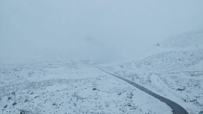
Het is alleen mogelijk om van Mendoza naar Uspallata te reizen. In het gebied van de Hoge Cordillera blijft het sneeuwen. Vanmiddag zullen de weersomstandigheden verbeteren, maar beide wegen zullen veel werk vereisen om de doorgang voor de komende dagen vrij te maken.

Alerte amarilla hier in Mar del Plata, tis vies koud ja, komt ook door de luchtvochtigheid hiero. Ben benieuwd of het hier vrijdag of zaterdag gaat sneeuwen, laatste keer was in juli 1997 even uit mijn hoofd (maar toen woonde ik hier nog niet).
Ik hou me bezig met het organiseren van reizen naar Argentinie, Chili en Peru voor Tipica Reizen.

A moody Friday at #Hotham. The next #snow bearing weather system is closing in! ❄️❄️
https://x.com/_hotham/status/1806465724866830553?s=19

https://x.com/_hotham/status/1806465724866830553?s=19
v
Er ligt genoeg sneeuw...quote:Op zaterdag 29 juni 2024 12:46 schreef Adrie072 het volgende:
Potverdikkie, zeggen dat je aan het apres-skiën bent in Hotham in de whatsapp, lijkt me wel wat!
v
Helaas geen sneeuw gehad hier in Mar del Plata zelf, wel in de omgeving. Komende nachten rond het vriespunt, maar geen neerslag (gelukkig hehe)
Ik hou me bezig met het organiseren van reizen naar Argentinie, Chili en Peru voor Tipica Reizen.
quote:De stad La Plata registreerde deze woensdag de laagste temperatuur in 57 jaar. Te midden van de koudegolf die La Plata teistert, heeft de Nationale Meteorologische Dienst de laagste temperatuur sinds 1967 in de stad geregistreerd.
De stad La Plata ervaart een koudegolf die een nieuw record van laagste temperatuur in 57 jaar heeft bereikt. Op woensdag 10 juli gaf de thermometer -5,7°C aan, een cijfer dat sinds 14 juni 1967 niet meer was geregistreerd, volgens de Nationale Meteorologische Dienst (SMN).
De foto's en video's die in de vroege uren van de dag werden gedeeld, tonen de impact van de extreme kou in de stad. Bevroren zwembaden en parken bedekt met een witte laag rijp zijn de afgelopen dagen een veelvoorkomend verschijnsel geworden.
https://www.0221.com.ar/l(...)-baja-57-anos-n94860
Mja, het is nog steeds frisjes ja  qel iedere middag heerlijk, volop zon, maar wel koud.
Ik hou me bezig met het organiseren van reizen naar Argentinie, Chili en Peru voor Tipica Reizen.
Een koud begin van de winter.quote:
Mja, het is nog steeds frisjes ja
Van wat ik begrijp toch redelijk uitzonderlijk. Maar mijn Spaans (of Portugees) is niet geweldig, ik moet alles vertalen via Google en dat is wel een ding
AI maakt er nog wel wat duidelijks van...maar blijft wel een dingetje.
Polar Vortex op het zuidelijk halfrond, wat voor nog kouder weer kan gaan zorgen.
quote:A rare sudden stratospheric warming event is beginning to occur above Antarctica, and it may influence Australia’s weather in the coming weeks.
The term sudden stratospheric warming (SSW) refers to an abrupt increase in air temperature high above either of Earth’s polar regions, typically on the magnitude of tens of degrees Celsius in a few days. This warming occurs in a layer of the atmosphere called the stratosphere, roughly 30 to 40km above the surface.
While warming in the stratosphere does not immediately (or always) affect weather patterns near the ground, SSW events can filter down through the atmosphere and influence tropospheric weather in the weeks following the initial SSW.
If an SSW event does make its way down to the troposphere, it can cause the tropospheric polar vortex to weaken, which allows cold polar air to drift further away from Antarctica (or the Arctic if in the Northern Hemisphere) and spread towards the mid-latitudes.
Through this domino effect, SSW events can cause the Southern Annular Mode (SAM) to shift into a negative phase, which can have the following impacts in Australia during winter:
More cold fronts and low pressure systems over southern Australia
Increased rainfall and snow potential in southwest and southeast Australia
Reduced rainfall in parts of eastern Australia
Stronger winds in the southern half of Australia
The Southern Annular Mode (SAM) is an index used to monitor the position of the westerly winds that flow from west to east between Australia and Antarctica. When the SAM is in a negative phase, these westerly winds, and the cold fronts and low pressure systems they carry, are located further north than usual for that time of year. When the SAM is positive, the westerly winds, cold fronts and low pressure systems are located further south than usual.
Sudden Stratospheric Warming underway
Warming has been detected in the stratosphere above the Antarctic region over the past week, revealing that an SSW event is starting to occur in the Southern Hemisphere. Some forecast models predict that this stratospheric warming will continue over the next week and start to filter down through the atmosphere later this month.
The graph below shows observed stratospheric temperatures in red and the forecast from one model in green. From these lines you can see a sudden increase in the temperature beyond the normal range, potentially getting even warmer than any other observed event at this time of year.
Image: Observed and forecast 10hPa temperature over the Southern Hemisphere’s polar region (90°S to 60°S) according to the GFS model.
It is currently unclear whether the stratospheric warming will influence weather closer to the ground in the coming weeks. However, some models are already showing signs that the SSW signal will descend to lower altitudes during the second half of July. If this trend continues, it will increase the likelihood of a shift towards a negative SAM in late July or August.
Videos: Forecast temperatures at the 10hPa (top) and 100hPa (bottom) levels in the atmosphere, according to the GFS model. The first animation shows warming over East Antarctica during the middle of July, which displaces the cold air within the stratospheric polar vortex. The second animation shows warming predicted to the south of Australia later in the month, indicating the downward progression of the SSW signal.
Since April, Australia has been affected by a stagnant long-wave ridge pattern, leading to persistent high pressure in the Bight. As a result, there has been drought in WA and SA, abnormally wet conditions along the east coast, and very low wind over western Vic. This SSW event may disrupt this pattern for the Australian region.
The images below show one forecast model predicting a shift towards lower sea level pressure near Australia in August, and an associated increase in precipitation for southern Australia, which are both consistent with a shift towards negative SAM.
Image: Forecast mean sea level pressure anomaly in August 2024 according to the ECMWF SEAS5 model.
Image: Forecast precipitation anomaly in August 2024 according to the ECMWF SEAS5 model.
What causes Sudden Stratospheric Warming?
SSW can be caused by large atmospheric ‘waves’ propagating upwards through the atmosphere and crashing into the stratospheric polar vortex. These waves can warm the polar stratosphere and weaken, or even reverse, the westerly winds that typically circulate above the poles in winter.
An SSW event can be classified as minor or major based on the magnitude of warming and changes to the wind speed and direction in the stratosphere:
A minor SSW occurs when the polar temperature increases by 25°C or more within one week at any stratospheric level
A major SSW requires an increase in temperature AND a reversal of the westerly winds at the 10hPa level in the polar regions.
Only a few SSW events have been observed in the Southern Hemisphere, with the most recent one occurring in 2019.
Weatherzone’s meteorologists will be keeping a close eye on the current SSW signal and updating the Weatherzone News feed in coming weeks.
Note to media: You are welcome to republish text from the above news article as direct quotes from Weatherzone. When doing so, please reference www.weatherzone.com.au in the credit.
Read More: https://x.com/Ben_Domensino/status/1811633854173901211?s=19
De koudegolf blijft de provincie Mendoza treffen en de Nationale Meteorologische Dienst (SMN) heeft het rode alarm uitgebreid naar verschillende delen van de provincie.
https://www.mendozapost.c(...)las-zonas-afectadas/
[ Bericht 6% gewijzigd door #ANONIEM op 14-07-2024 19:53:18 ]
https://www.mendozapost.c(...)las-zonas-afectadas/
[ Bericht 6% gewijzigd door #ANONIEM op 14-07-2024 19:53:18 ]
De polar Vortex, boven Antarctica, lijkt verstoord te worden, waardoor een zogenaamde sudden stratospheric warming (SSW) kan gaan ontstaan. Dit kan voor aanzienlijk kouder weer gaan zorgen in Argentinië, New Zeeland en het zuiden van Australië.
quote:Every winter, the polar vortex forms high above Antarctica in the polar stratosphere. This year, the vortex is showing signs of being disturbed 🐧
During winter in the Southern Hemisphere, a ring of stormy and freezing weather encircles Antarctica. Known as the polar vortex, it is usually very good at keeping harsh, wintry conditions locked up close to the pole.
➡️ Every once in a great while, the polar stratosphere can warm dramatically during a phenomenon called a sudden stratospheric warming (SSW).
These events have specific criteria that need to be met. A minor SSW requires stratopsheric temperatures to rise at least 25˚C in a week. A major SSW requires both warming combined with a dramatic reduction in stratospheric winds.
Right now, a pattern of warming is being observed in the stratosphere above East Antarctica. It is uncertain if it will reach the threshold needed to qualify as a *minor* SSW, but it may be close. A major SSW looks quite unlikely at this point.
When a SSW occurs, it can help to weaken or displace the polar vortex in the stratosphere, which then filters down onto the tropospheric polar vortex and influences our weather patterns.
These events are rare in the Southern Hemisphere. There have only been three in the satellite era: September 2002, September 2010, and August-September 2019. After the SSW in 2002, New Zealand experienced its coldest October in 20 years with below average temperatures covering much of the country and frequent ground frosts. In 2010 – which is classed as minor event – a number of rainfall records were broken with well below normal sunshine and very cold temperatures in parts of the South Island.
This year, there are some signs that the developing anomalies in the stratosphere may indeed couple with the troposphere, ultimately affecting hemispheric weather patterns. The early indication is for above normal pressures to develop over Antarctica during late July. This will force lower pressures across the mid-latitudes of the hemisphere, including New Zealand and Australia, leading to stormier conditions.
The effects can last for up to a month or two, so this unique climate driver may be with us through August.
https://x.com/peakaustria(...)Jw0OOJ6SP09Webw&s=19
Ja ho effe, het is wel genoeg geweest he? De nachttemperaturen gaan nu weer boven 0 zag ik en dat is wel best hoor!
Ik hou me bezig met het organiseren van reizen naar Argentinie, Chili en Peru voor Tipica Reizen.
Tot 80 cm sneeuw in het zuiden van Australië.
quote:The extreme cold front dumped thick snow on the popular winter playgrounds of Thredbo, in the NSW Snowy Mountains, and Victoria’s alpine slopes, creating an incredible frozen landscape.
Blizzard conditions occurred above 1200 metres in alpine regions, but were expected to ease early Sunday morning.
https://www.thenewdaily.c(...)1/cold-blast-weather


Hier in Mar del Plata wordt het de komende week 16-19 graden 
Ik hou me bezig met het organiseren van reizen naar Argentinie, Chili en Peru voor Tipica Reizen.
Einde winter even.quote:
Hier in Mar del Plata wordt het de komende week 16-19 graden
Alhoewel het nog echt wel koud kan gaan worden...
[ Bericht 0% gewijzigd door #ANONIEM op 21-07-2024 15:01:12 ]
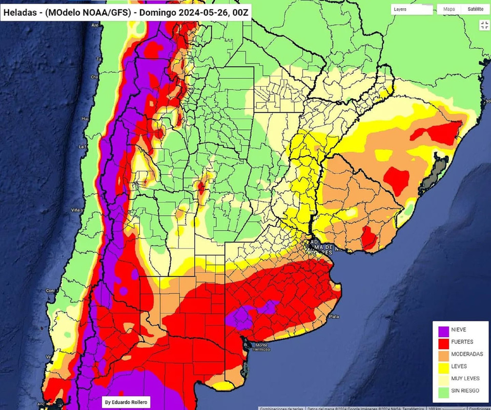
In het zuiden van Zuid-Amerika is de winter zeer koud begonnen. Er viel veel sneeuw in de zuidelijke delen van Chili en Argentinië en rivieren vroren dicht. In Patagonië, Argentinië, was het zelfs het koudst sinds 1907. Daar werden temperaturen van -25°C gemeten, waardoor het tijdelijk één van de koudste gebieden in de wereld was.
Wind uit het zuiden voerde steeds nieuwe golven met koude lucht aan. Storingen brachten tegen de bergen grote hoeveelheden sneeuw, dat in skigebieden voor het eerst al zo vroeg in het seizoen enkele meters sneeuw opleverde. De zuidenwind werd veroorzaakt door een blokkerend hogedrukgebied dat voor de Chileense kust op de Grote Oceaan lag. Na de eerste week van juli kwam het drukgebied van zijn plek en dat ging gepaard met een westelijke wind en wisselvalliger weer. Ook in Zuid-Afrika heeft het gesneeuwd en zijn er veel stormen geweest, meegebracht door de fronten vanuit het zuidwesten.
Op de Zuidpool werd bijna een julirecord verbroken. Een weerstation op Antarctica heeft vorige week een temperatuur van -82,1°C gemeten, het koudste in 2024 op de hele aarde tot nu toe. Tien jaar geleden werd het daar slechts iets kouder met -82,9°C, waardoor het record net niet is verbroken. Zulke lage temperaturen zijn op Antarctica niet zeldzaam omdat de zon overdag nauwelijks schijnt. De temperatuur kan in het binnenland van het continent dalen tot -60°C of lager. De laagste temperatuur ooit is -89,2°C en werd gemeten op het Vostok Station op Antarctica.
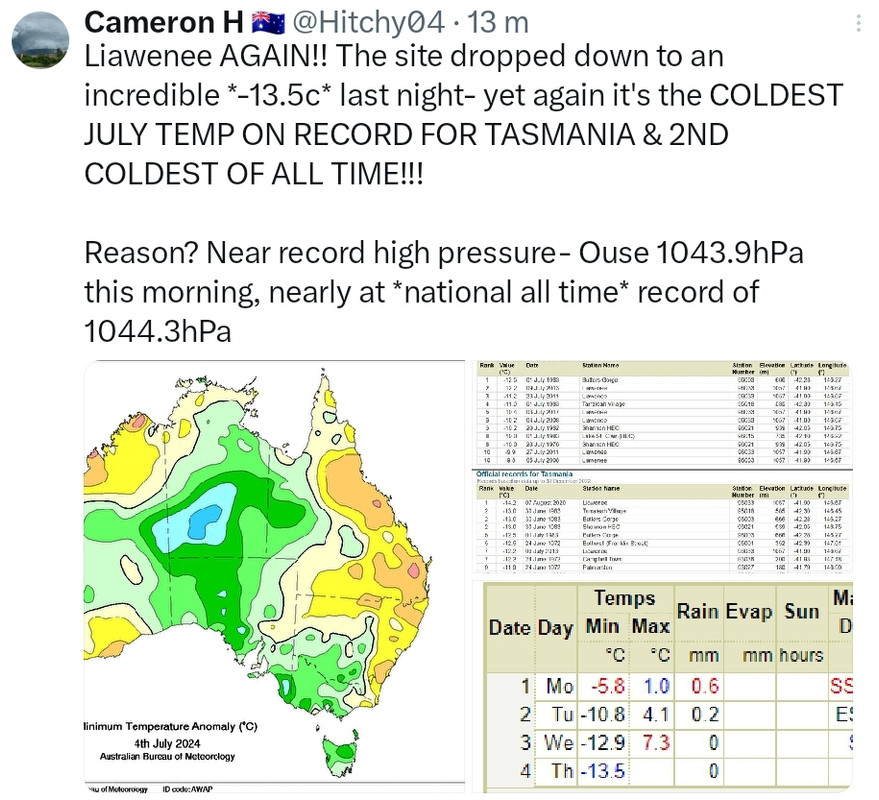
In de zuidelijke gebieden van Australië kan het in de winter erg koud zijn door koude lucht die via Tasmanië het continent binnenstroomt. De noordelijke gebieden zijn tropisch, daar kan het het hele jaar door warmer worden dan 30 graden. De koude lucht kon afgelopen week deze noordelijke gebieden te bereiken, iets wat normaal gesproken niet gebeurt. In het plaatsje Charters Towers, gelegen op -20 breedtegraad in Queensland, werd een minimumtemperatuur van 0,1°C gemeten. De normale gemiddelde minimumtemperatuur in juli is daar 11,6°C, een enorm verschil. Het is de laagst gemeten temperatuur in juli sinds het jaar 1899. Ook bleef het overdag in Queensland zeer koud en is het laagste maximum sinds 2015 gemeten toen het op 17 juli slechts 6 graden werd.
De temperaturen keren inmiddels weer terug naar normale waarden. Het was een bijzondere periode van kou, maar het lijkt nu te zijn afgelopen.
https://www.weer.nl/nieuw(...)t-zuidelijk-halfrond
Wind uit het zuiden voerde steeds nieuwe golven met koude lucht aan. Storingen brachten tegen de bergen grote hoeveelheden sneeuw, dat in skigebieden voor het eerst al zo vroeg in het seizoen enkele meters sneeuw opleverde. De zuidenwind werd veroorzaakt door een blokkerend hogedrukgebied dat voor de Chileense kust op de Grote Oceaan lag. Na de eerste week van juli kwam het drukgebied van zijn plek en dat ging gepaard met een westelijke wind en wisselvalliger weer. Ook in Zuid-Afrika heeft het gesneeuwd en zijn er veel stormen geweest, meegebracht door de fronten vanuit het zuidwesten.
Op de Zuidpool werd bijna een julirecord verbroken. Een weerstation op Antarctica heeft vorige week een temperatuur van -82,1°C gemeten, het koudste in 2024 op de hele aarde tot nu toe. Tien jaar geleden werd het daar slechts iets kouder met -82,9°C, waardoor het record net niet is verbroken. Zulke lage temperaturen zijn op Antarctica niet zeldzaam omdat de zon overdag nauwelijks schijnt. De temperatuur kan in het binnenland van het continent dalen tot -60°C of lager. De laagste temperatuur ooit is -89,2°C en werd gemeten op het Vostok Station op Antarctica.
In de zuidelijke gebieden van Australië kan het in de winter erg koud zijn door koude lucht die via Tasmanië het continent binnenstroomt. De noordelijke gebieden zijn tropisch, daar kan het het hele jaar door warmer worden dan 30 graden. De koude lucht kon afgelopen week deze noordelijke gebieden te bereiken, iets wat normaal gesproken niet gebeurt. In het plaatsje Charters Towers, gelegen op -20 breedtegraad in Queensland, werd een minimumtemperatuur van 0,1°C gemeten. De normale gemiddelde minimumtemperatuur in juli is daar 11,6°C, een enorm verschil. Het is de laagst gemeten temperatuur in juli sinds het jaar 1899. Ook bleef het overdag in Queensland zeer koud en is het laagste maximum sinds 2015 gemeten toen het op 17 juli slechts 6 graden werd.
De temperaturen keren inmiddels weer terug naar normale waarden. Het was een bijzondere periode van kou, maar het lijkt nu te zijn afgelopen.
https://www.weer.nl/nieuw(...)t-zuidelijk-halfrond
v
lees hier verderquote:Een intense hittegolf teistert al sinds half juli het centrale en oostelijke deel van Antarctica. „Op sommige plekken ligt de temperatuur 20 tot 25 graden Celsius boven het normale gemiddelde”, zegt Tom Bracegirdle, atmosfeerwetenschapper van de British Antarctic Survey. „Het is echt verbazingwekkend.” Gemiddeld voor het hele continent liggen de temperaturen nu rond de -20°C; normaal is dat ongeveer -30°C in deze tijd van het jaar.
Het is de tweede keer in drie jaar tijd dat zich tijdens de winter op Antarctica, als er nauwelijks zonlicht is, een heftige hittegolf voordoet. Tussen 15 en 19 maart 2022 lagen de temperaturen zelfs 30 tot 40°C boven het gemiddelde. Die hittegolf duurde wel korter, zegt Bracegirdle. „En de oorzaak was anders dan nu.”
v
Wat is eigenlijk het oostelijke deel van antartica? Als je op de zuidpool staat is elke richting toch noordelijk 
R.I.P. kat. Ik was er toch best gek mee. ;(
Rechts van lengtegraad o is Oost en links daarvan is west.quote:
Wat is eigenlijk het oostelijke deel van antartica? Als je op de zuidpool staat is elke richting toch noordelijk
v
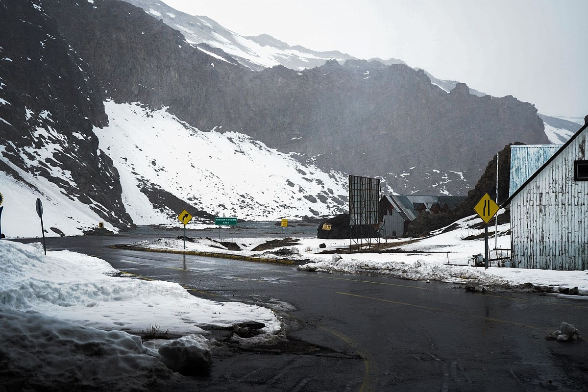
Tussen Argentinie en Chili is weer een bergpas gesloten voor verkeer.
https://www.mdzol.com/soc(...)redentor-780457.html
https://www.mdzol.com/soc(...)redentor-780457.html


Niet zomaar een bergpas, de belangrijkste: tussen Santiago de Chile en Mendoza.
Ik hou me bezig met het organiseren van reizen naar Argentinie, Chili en Peru voor Tipica Reizen.
Hier in Mar del Plata was het gisteren 20 graden en volle zon. Vandaag ook zonnig, maar slechts 14 graden. De nachten zijn nog frisjes, 4-5 graden dus de kachel nog wel aan in het hondenhotel. Maar het wordt duidelijk voorjaar, al mooie bloessem van fruitbomen en dikke knoppen in de kastanje gezien 
Ik hou me bezig met het organiseren van reizen naar Argentinie, Chili en Peru voor Tipica Reizen.
quote:A slow-moving front over the south of the South Island is bringing "significant" snow to Queenstown Lakes, Southland and inland Otago, as well as heavy rain.
The latest forecast came after a heavy dump of snow in the South Island on Friday caused power outages, shut schools and closed roads.
A heavy snow warning is in place until 10pm Sunday for the Queenstown Lakes District south of Wanaka and for Southland north of Mossburn and west of Athol.
MetService said to expect 12-18cm of snow to accumulate above 400 metres, warning that further snow was expected on Monday night and into Tuesday.
Heavy snow was also expected until 5am Monday in Southland, north of Lumsden and from Athol eastwards, as well as inland Otago excluding the Queenstown Lakes District.
In those areas, people could expect 10-20 cm of snow to settle above 400 metres, with lesser amounts down to 300 metres.
The snow could disrupt travel and damage trees and powerlines, and cold conditions may cause stress for livestock, it said.
MetService warned people to prepare for snow, cold temperatures, and possible power outages.
"If you must travel, drive cautiously, and ensure you have snow chains, sleeping bags, warm clothing, and emergency items."
https://www.rnz.co.nz/new(...)r-lower-south-island
Twee doden bij sneeuwstormen in Zuid-Afrika
In het oosten van Zuid-Afrika zijn twee doden gevallen bij sneeuwstormen die in het weekend over het gebied trokken. De stormen vonden laat in het seizoen plaats en leidden tot problemen op verschillende snelwegen.
Een aantal snelwegen in het gebied moest worden afgesloten. De twee slachtoffers kwamen om door onderkoeling. Ze zaten vast in voertuigen die waren gestrand vanwege de hevige sneeuwval op de snelweg N3, de belangrijkste weg naar de kuststad Durban.
Hulpdiensten hebben tientallen vrachtwagens en andere voertuigen uit de sneeuw gesleept. Ook werd voedsel en warme drank uitgedeeld aan chauffeurs die urenlang vastzaten.
Scholen gesloten
De provincies KwaZoeloe-Natal en Vrijstaat werden het zwaarst getroffen door de sneeuwstormen. Onder meer scholen werden gesloten.
Functionarissen waarschuwen dat sommige gebieden met overstromingen te maken kunnen krijgen als de sneeuw begint te smelten. "Aangezien de scholen gesloten blijven, worden ouders dringend verzocht kinderen weg te houden van rivieren en dammen", zegt een regionale bestuurder.
https://nos.nl/artikel/25(...)ormen-in-zuid-afrika
|
|