WKN Weer, Klimaat en Natuurrampen
Lees alles over het onstuimige weer op onze planeet, volg orkanen en tornado's, zie hoe vulkanen uitbarsten en hoe Moeder Aarde beeft bij een aardbeving. Alles over de verwoestende kracht van onze planeet en tal van andere natuurverschijnselen.



Nou hier is anders wel een fotolijstje aan gruzelementenquote:Op maandag 8 september 2025 23:38 schreef Perrin het volgende:
[..]
Ai, ja ik las het. Nog weinig officiele gegevens. Vooralsnog lijkt er geen schade.
[ x ]

Was wel een van de heftigere sinds ik hier woon (2021). Iedereen ging even op zijn balkon kijken of alles oké was, overal zag je opeens lichten aan gaan.
[ Bericht 0% gewijzigd door #ANONIEM op 08-09-2025 23:46:26 ]


Zeker 20 doden op de Filippijnen na een 6.9 beving
https://www.hln.be/buiten(...)astklampen~a53b65f4/
https://www.hln.be/buiten(...)astklampen~a53b65f4/


Er wordt melding gemaakt van een aardbeving bij Istanbul van 5.0
Oh, is al 2 dagen geleden
Oh, is al 2 dagen geleden
Wie dit leest is een lezer van dit



<a href="http://www.vwkweb.nl/" rel="nofollow" target="_blank">[b]Vereniging voor weerkunde en klimatologie[/b]</a>
<a href="http://www.estofex.org/" rel="nofollow" target="_blank">[b]ESTOFEX[/b]</a>
<a href="http://www.estofex.org/" rel="nofollow" target="_blank">[b]ESTOFEX[/b]</a>

quote:Second earthquake strikes Cyprus, felt in Israel
Epicenter of the morning quake, with a magnitude of 5.2, was Paphos in Cyprus - and then an aftershock with a magnitude of 4.7 was felt; In the afternoon, another earthquake with a magnitude of 5.9 struck; Residents from the northern and central regions reported to Ynet that they felt the tremors
Two earthquakes centered in Cyprus were felt in Israel on Wednesday. The first tremor occurred at 11:31 a.m. and was felt in northern parts of the country. According to the European-Mediterranean Seismological Centre, the epicenter was near Paphos, Cyprus, at a depth of 21 kilometers, with a magnitude of 5.2.
A second quake was felt at 4:25 p.m. in both northern and central Israel from the same epicenter and with a magnitude of 5.9.

Aardbeving met kracht van 3,4 in Groningen, een van de zwaarste ooit
In Groningen is vannacht een aardbeving geweest met een kracht van 3,4. Volgens het KNMI is dit de op twee na zwaarste beving ooit gemeten in de provincie. De aardbeving werd in een groot deel van Groningen gevoeld. Over schade is nog niets bekend.
De beving was om 01.16 uur. Het epicentrum van de beving lag bij Zeerijp, 10 kilometer ten westen van Delfzijl. De beving deed zich voor op 3 kilometer diepte.
https://nos.nl/artikel/25(...)van-de-zwaarste-ooit
In Groningen is vannacht een aardbeving geweest met een kracht van 3,4. Volgens het KNMI is dit de op twee na zwaarste beving ooit gemeten in de provincie. De aardbeving werd in een groot deel van Groningen gevoeld. Over schade is nog niets bekend.
De beving was om 01.16 uur. Het epicentrum van de beving lag bij Zeerijp, 10 kilometer ten westen van Delfzijl. De beving deed zich voor op 3 kilometer diepte.
https://nos.nl/artikel/25(...)van-de-zwaarste-ooit
Die gast bij de NOS vanochtendquote:Op vrijdag 14 november 2025 06:33 schreef Pino112 het volgende:
Aardbeving met kracht van 3,4 in Groningen, een van de zwaarste ooit
In Groningen is vannacht een aardbeving geweest met een kracht van 3,4. Volgens het KNMI is dit de op twee na zwaarste beving ooit gemeten in de provincie. De aardbeving werd in een groot deel van Groningen gevoeld. Over schade is nog niets bekend.
De beving was om 01.16 uur. Het epicentrum van de beving lag bij Zeerijp, 10 kilometer ten westen van Delfzijl. De beving deed zich voor op 3 kilometer diepte.
https://nos.nl/artikel/25(...)van-de-zwaarste-ooit

"Het is de grootste beving in jaren. Al jaren hoopten de bewoners van de regio dat door het dichtdraaien van de gaskraan de grote bevingen achterwege zouden blijven. Maar dat dat dit soort bevingen mogelijk zouden zijn was wel bekend. Desondanks kwam de zware beving van vannacht voor veel mensen toch nog als grote schok"

Niet zo netjes dat iedereen nu in een scheur ligt om de garpjes van de NOS.
And what rough beast, its hour come round at last,
Slouches towards Bethlehem to be born?
Slouches towards Bethlehem to be born?
Er schijnt vannacht in Limburg een aardbeving te zijn geweest, maar itt die van 1992 ben ik nu niet wakker geschud 
"You can call me Susan if it makes you happy"


Iets voor 12 uur is er een aardbeving van 5,3 op IJsland geweest.
Misschien binnenkort weer een uitbarsting?quote:5,3 Magnitude Earthquake
10,00 kilometer depth (6,21 miles)
1/31/2026 12:54 p.m.
110 km S of Akureyri, Iceland
USGS PAGER RESPONSE
No PAGER Issued
TSUNAMI WARNING
No Alert Issued
Weerstation Dokkum voor het actuele weer in de Friese 11steden stad
Doe mee met het voorspellen van het weer!
Weekvoorspelling | Maandvoorspelling Augustus | Jaarvoorspelling 2026
Doe mee met het voorspellen van het weer!
Weekvoorspelling | Maandvoorspelling Augustus | Jaarvoorspelling 2026
Ik moet eerlijk bekennen dat ik nooit geweten heb dat dat noorderlijke deel van dat eiland schijnbaar bij Maleisie hoort en niet bij Indonesiequote:


En dan ligt Brunei ook nog in dat stukje Maleisiequote:Op zondag 22 februari 2026 18:23 schreef Frutsel het volgende:
[..]
Ik moet eerlijk bekennen dat ik nooit geweten heb dat dat noorderlijke deel van dat eiland schijnbaar bij Maleisie hoort en niet bij Indonesie
Opmerkelijk zware beving bij Napels gisteren. 6.0
quote:Strong M6.0 earthquake hits Tyrrhenian Sea near Naples, Italy
A strong earthquake registered by the USGS as M6.0 struck near Naples, Italy, at 23:03 UTC on March 9, 2026 (00:03 LT on March 10). The agency is reporting a depth of 373 km (232 miles). EMSC is reporting M5.9 at a depth of 375 km (233 miles).
The epicenter was located 16.5 km (10.2 miles) SSE of Sant’Angelo (population 1 245), 19.5 km (12.1 miles) S of Ischia (population 18 564), 19.6 km (12.2 miles) S of Ischia Porto (population 18 192), 21.6 km (13.4 miles) SSE of Forio (population 15 969), and 40.4 km (25.1 miles) SW of Naples (population 909 048), Campania, Italy.
7 000 people are estimated to have felt light shaking, and 14 425 000 weak.
The USGS issued a Green alert for shaking-related fatalities and economic losses. There is a low likelihood of casualties and damage.
Overall, the population in this region resides in structures that are a mix of vulnerable and earthquake-resistant construction. The predominant vulnerable building types are unreinforced brick with mud and unknown or miscellaneous construction types.
Recent earthquakes in this area have caused secondary hazards such as landslides that might have contributed to losses.
The Mediterranean region is seismically active due to the ongoing convergence of the African and Eurasian plates at a rate of about 4 to 10 mm (0.15 to 0.4 inches) per year. This tectonic interaction began roughly 50 million years ago with the closure of the ancient Tethys Ocean, whose remnants form today’s Mediterranean Sea.
Much of the region’s seismicity occurs along major tectonic structures such as the Hellenic subduction zone south of Greece, the North Anatolian Fault Zone in Turkey, and the Calabrian subduction zone beneath southern Italy. These plate interactions generate frequent earthquakes as well as complex crustal deformation across the region.
Historically, destructive earthquakes and tsunamis have affected large parts of the Mediterranean, including Greece, Italy, Turkey, and North Africa. One of the deadliest events in Europe was the 1908 M7.2 Messina earthquake in southern Italy, which caused severe damage and a tsunami, killing an estimated 60 000 to 120 000 people.
Today’s earthquake occurred at a depth of 373 km (232 miles) — deep within the subducting African plate beneath southern Italy. It is unlikely to be related to volcanic activity at Campi Flegrei or Mount Vesuvius.
Een vrij forse bij Tonga.
And what rough beast, its hour come round at last,
Slouches towards Bethlehem to be born?
Slouches towards Bethlehem to be born?

 Op
Op
Inwoners van Californie wakker geschud...
[ Bericht 19% gewijzigd door Frutsel op 02-04-2026 11:05:11 ]
[ Bericht 19% gewijzigd door Frutsel op 02-04-2026 11:05:11 ]
Leek eerst magnitude 5.1 te zijn
EMSC gooit hem op 4.9
EMSC gooit hem op 4.9
quote:4.9
Region NORTHERN CALIFORNIA
Date time 2026-04-02 08:41:24.7 UTC
Location 37.097 ; -122.085
Depth 10 km
Distance 31 km S of Sunnyvale, United States / pop: 155,000 / local time: 01:41:24.7 2026-04-02
14 km NNW of Santa Cruz, United States / pop: 64,200 / local time: 01:41:24.7 2026-04-02

Nee vrij zeldzaam.quote:
[ x ]
Niet echt een plek waar je normaal aardbevingen ziet toch?
And what rough beast, its hour come round at last,
Slouches towards Bethlehem to be born?
Slouches towards Bethlehem to be born?
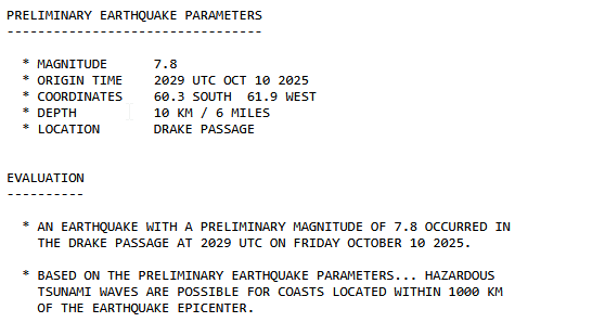
quote:Doden in Filipijnen door aardbeving, gevaar van tsunami's geweken
In de Filipijnen zijn zeker negentien mensen omgekomen na een aardbeving met een kracht van 7,8. De beving was voor de kust in het zuiden van de archipel. Meer dan 200 mensen raakten gewond.
Op het zuidelijke eiland Mindanao is er veel schade en zijn gebouwen ingestort. Dat gebeurde onder meer in de stad General Santos, waar zo'n 700.000 mensen wonen. Daar kwamen zeven mensen om het leven. In ingestorte gebouwen wordt nog gezocht naar vermisten.
Zo stortte een dak bij een school in terwijl de kinderen buiten stonden tijdens de aardbeving:
Na de beving waren er zeker zestien naschokken, waarvan de zwaarste met een kracht van 6,5. De Filipijnse president heeft mensen opgeroepen om naar hogergelegen gebied te gaan.
Omdat de beving op zee was werden er tsunamiwaarschuwingen afgegeven, ook in buurlanden. Langs de noordkust van het Indonesische eiland Sulawesi zijn vloedgolven gezien van zo'n 75 centimeter. Ook in de Maleisische provincie Sabah op het eiland Borneo werd een dergelijke golf gezien. Er zijn geen berichten over schade of slachtoffers.
De instantie die waarschuwt voor tsunami's op de Stille Oceaan zei zo'n vijf uur na de zeebeving dat het gevaar was geweken.
Bij zo eentje gewoon eigen topic maken hoorquote:
Forse in de Filippijnen. Overzicht USGS.
[ x ]

Jongens....
Maak nou voor dut soort bevingen aub een eigen topic in WKN.
Gezien de schade en kracht moet dat gewoon.
Nws heeft er ook eentje
NWS / Zware aardbeving in Venezuela. Mogelijk duizenden doden.
Maak nou voor dut soort bevingen aub een eigen topic in WKN.
Gezien de schade en kracht moet dat gewoon.
Nws heeft er ook eentje
NWS / Zware aardbeving in Venezuela. Mogelijk duizenden doden.


Beelden vanuit Quetzaltenango, Guatemala. Toch stukje verder op.
https://www.facebook.com/(...)&id=1068938955662831
https://www.facebook.com/(...)&id=1068938955662831
Forse beving bij Campi Flegrei.
The big one is coming?
The big one is coming?
And what rough beast, its hour come round at last,
Slouches towards Bethlehem to be born?
Slouches towards Bethlehem to be born?
quote:Aardbeving met kracht van 4,3 nabij Pisa: scheve toren houdt stand
De Italiaanse stad Pisa, in Toscane, werd dinsdag opgeschud door een aardbeving met een kracht van 4,3. De beving zorgde volgens de autoriteiten kort voor paniek in de straten, maar er zijn nog geen meldingen van gewonden of schade.
Rond 10.15 uur dinsdagvoormiddag stroomden honderden telefoontjes binnen bij de Italiaanse noodcentrale, nadat Pisa werd opgeschud door een aardbeving. Volgens het Italiaanse instituut voor seismologie en vulconologie had de beving een kracht van 4,3 en lag het epicentrum op zo'n zeven kilometer van de stad.
Pisa is wereldwijd bekend om zijn scheve toren, die jaarlijks duizenden toeristen lokt. Volgens de autoriteiten raakte de toren niet beschadigd en blijft hij open. De trillingen waren ook voelbaar in Lucca en andere populaire steden voor toeristen in de regio. Uit voorzorg vonden er wel enkele evacuaties plaats, klinkt het bij de Toscaanse overheid.
Italië ligt op de grens tussen de Afrikaanse en Euraziatische tektonische platen, waardoor het hele land regelmatig door aardbevingen wordt getroffen. Afgelopen weekend werd de Zuid-Italiaanse stad Napels getroffen door een krachtige aardbeving, de sterkste in veertig jaar. Bij de aardbeving met een magnitude van 4,7 raakten 26 mensen gewond
Ik vind dit soort teksten altijd zo jammer. Het klopt niet, de Afrikaanse plaat begint toch echt bij Afrika zelf, niet midden in de Middellandse Zee. Alleen de tenen van Italië zijn een uitzondering. En Italië zelf ligt ook niet op de Euraziatische plaat, hoe anders kan het onder de Alpen liggen?quote:
Italië ligt op de grens tussen de Afrikaanse en Euraziatische tektonische platen
/autist modus
100.000 katjes
Fuck the EBU!
Fuck the EBU!
Waarom hebben ze het niet over de slab pull van de Apulische plaat?quote:
[..]
Ik vind dit soort teksten altijd zo jammer. Het klopt niet, de Afrikaanse plaat begint toch echt bij Afrika zelf, niet midden in de Middellandse Zee. Alleen de tenen van Italië zijn een uitzondering. En Italië zelf ligt ook niet op de Euraziatische plaat, hoe anders kan het onder de Alpen liggen?
/autist modus

And what rough beast, its hour come round at last,
Slouches towards Bethlehem to be born?
Slouches towards Bethlehem to be born?
Gecompliceerde geofyschische regio .... Hoop dat er weing overlast isquote:
7.7 op 10km diepte bij Indonesië
https://earthquake.usgs.g(...)us6000tkt2/executive
waar is het eigen topic?quote:
7.7 op 10km diepte bij Indonesië
https://earthquake.usgs.g(...)us6000tkt2/executive

Rommelt wel door in Spanje... 5.0 van de week bij Malaga, nu weer een 4.8
quote:Magnitude 4.8
Region SPAIN
Date time 2026-08-18 08:37:45.8 UTC
Location 37.117 ; -3.659
Depth 5 km
Distance 81 km NE of Málaga, Spain / pop: 568,000 / local time: 10:37:45.8 2026-08-18
9 km SSW of Granada, Spain / pop: 234,000 / local time: 10:37:45.8 2026-08-18

Het valt nog mee...maar deze drie (van 7+) kwamen wat meer in de media (Venezuela, Colombia en Indonesie)quote:
Beetje opvallend veel momenteel of is dat niet zo?
Waarvan twee in augustus.
Gemiddeld per jaar 15-18 aardbeving op de wereld van 7 of hoger.
We zitten "nog maar" op 11 in 2026.
Gemiddeld zitten we trouwens ook op 1 van 8 of hoger, maar die hebben we dit jaar nog niet gehad.

(In 2025 wel, maar in 2022, 2023, 2024 helemaal niet, daarentegen in 2021 hadden we er drie van 8+)
quote:Andalucia, Granada, earthquakes explained
RESIDENTS in Granada were abruptly awoken in the early hours of Saturday after a powerful earthquake shook the city, sending terrified locals fleeing into the streets and causing damage to buildings and vehicles.
The magnitude-5 tremor – later downgraded to 4.8 by the National Geographic Institute (IGN) – struck shortly after 1am, with its epicentre located in Alhendin, south-west of Granada.
The rumble was felt across much of Andalucia and as far away as Madrid, while more than 200 calls were made to emergency services.
No injuries have been reported, although falling debris damaged cars and buildings and several people had to be rescued from lifts.
The quake was then followed by a series of aftershocks, prompting some residents to spend their night outside their homes amid fears that further tremors could follow.
But while an earthquake of this ilk is more than enough to give hardened locals a fright, Granada is no stranger to seismic activity.
In fact, the Granada Basin is one of the most seismically active areas in the Iberian Peninsula, with frequent shallow earthquakes of low to moderate magnitude.
Why does Andalucia shake so much?
The answer, as you would expect, lies deep beneath the ground.
Southern Spain, including the Costa del Sol, sits close to the complex and still-active boundary between the African and Eurasian tectonic plates.
The two plates are continuing to converge at around 5mm a year, according to experts, creating enormous stresses that are released occasionally through a network of faults running beneath the region.
The resulting seismic activity is particularly pronounced along the Betic mountain range, which stretches across much of Andalucia.
Around Granada, active faults cut through the intramountain basins surrounding the city, producing the shallow tremors often felt by locals and expats.
Most of these earthquakes are relatively small, however, and serious destructive events remain rare, although the region has experienced some major earthquakes throughout history.
That includes a magnitude-7.8 earthquake in 1954 and a magnitude-6.3 quake in 2010.
But these tremors caused no damage and no casualties because their epicentres were located at extreme depths of more than 600km below the earth’s crust, which will undoubtedly reassure anxious locals.
|
|
