WKN Weer, Klimaat en Natuurrampen
Lees alles over het onstuimige weer op onze planeet, volg orkanen en tornado's, zie hoe vulkanen uitbarsten en hoe Moeder Aarde beeft bij een aardbeving. Alles over de verwoestende kracht van onze planeet en tal van andere natuurverschijnselen.


Meer over vulkanen weten en het laatste nieuws bijhouden?
Lees ook:
WKN / [Vulkanen] The Ring of Fire #8: Het rommelt en borrelt
[ Bericht 4% gewijzigd door Frutsel op 16-01-2022 13:30:35 ]
Beste geweest:
Beste klap op afstand
Beste klap op afstand
Never Stop Exploring!
Life begins at the end of your comfort zone!
Follow me on Twitter: https://twitter.com/EdwinKr83 Instagram: https://www.instagram.com/edwinkr83/
Life begins at the end of your comfort zone!
Follow me on Twitter: https://twitter.com/EdwinKr83 Instagram: https://www.instagram.com/edwinkr83/
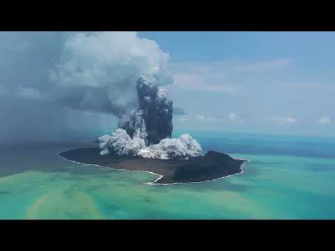
Zo! Da's wel ff een dikke knal, maar die haalt het nog niet bij Krakatoa in 1883.
[ Bericht 2% gewijzigd door DemonRage op 15-01-2022 15:04:14 ]
[ Bericht 2% gewijzigd door DemonRage op 15-01-2022 15:04:14 ]
Die klap was zeker hard, de tering!
Enig idee hoe groot de afstand is van de vulkaan en op het moment van de opname?
Enig idee hoe groot de afstand is van de vulkaan en op het moment van de opname?
'It's a boy'
65-70km, maar de explosie is ook gehoord in Nieuw-Zeeland op 2000km afstandquote:Op zaterdag 15 januari 2022 15:06 schreef Ivy_Mike het volgende:
Die klap was zeker hard, de tering!
Enig idee hoe groot de afstand is van de vulkaan en op het moment van de opname?

De knal van de vulkaan op tonga is een scheet vergeleken mat de Krakatoa.quote:Zo! Da's wel ff een dikke knal, maar die haalt het nog niet bij Krakatoa in 1883
De uitbarsting van de Krakatoa had een kracht van 200MT, dus 4x Tsar Bomba.
Er waren zeelui op een afstand van ca 65 km van het vulkaan, die de klap ervaarden die zo hard was, dat hun trommelvliezen letterlijk eruit knalden en de rest van hun leven stokdoof werden. De geluidsdruk werd geschat op
180 dB. De knal was nog 5000km te horen.
'It's a boy'

Wait, what? Ik dacht dat dit na de eruptie was, maar het is nu nacht daar.. deze foto is van twee uur voor de explosie :-o
"Light thinks it travels faster than anything. It doesn't. For wherever light travels it finds darkness has got there first and is waiting for it."
De
Hold my canada dry:quote:
"Light thinks it travels faster than anything. It doesn't. For wherever light travels it finds darkness has got there first and is waiting for it."


De hoofdstad van Tonga, dat gisteren werd getroffen door een zware vulkaanuitbarsting, heeft in ieder geval 'significante schade'. Dat zijn de eerste berichten, die via de Nieuw-Zeelandse ambassade de buitenwereld bereiken. Wat de toestand buiten de hoofdstad is, is nog steeds onbekend. Maar de zorgen zijn groot.
Door de uitbarsting zijn alle telefoon- en internetverbindingen tussen de eilandenstaat en de buitenwereld afgesloten. Het is daarom onduidelijk wat de schade in Tonga precies is en of er slachtoffers zijn gevallen onder de 105.000 bewoners van het eiland.
Op sociale media is te zien hoe golven van 1,2 meter steden op het eiland overspoelen.
Doet me alvast een beetje denken aan die orkaan die over onder anderen Dominica raasde toen, waar het dagenlang eigenlijk alleen maar mondjesmaat contact was via radio-amateurs enzoquote:Op zondag 16 januari 2022 13:30 schreef aloa het volgende:
De hoofdstad van Tonga, dat gisteren werd getroffen door een zware vulkaanuitbarsting, heeft in ieder geval 'significante schade'. Dat zijn de eerste berichten, die via de Nieuw-Zeelandse ambassade de buitenwereld bereiken. Wat de toestand buiten de hoofdstad is, is nog steeds onbekend. Maar de zorgen zijn groot.
Door de uitbarsting zijn alle telefoon- en internetverbindingen tussen de eilandenstaat en de buitenwereld afgesloten. Het is daarom onduidelijk wat de schade in Tonga precies is en of er slachtoffers zijn gevallen onder de 105.000 bewoners van het eiland.
Op sociale media is te zien hoe golven van 1,2 meter steden op het eiland overspoelen.
[ twitter ]
En laatst nog bij de Filipijnen.quote:
[..]
Doet me alvast een beetje denken aan die orkaan die over onder anderen Dominica raasde toen, waar het dagenlang eigenlijk alleen maar mondjesmaat contact was via radio-amateurs enzo
WKN / Zeker 400 doden bij zeer zware orkaan Rai in de Filipijnen
Eerste doden gemeld na vulkaanuitbarsting Tonga
Ruim een dag na de heftige onderzeese vulkaanuitbarsting bij Tonga zijn de eerste overledenen officieel gemeld. Niet op de getroffen eilandstaat in de Stille Oceaan of het nabijgelegen Nieuw-Zeeland. Maar in Peru, zo'n 10.000 kilometer verderop, waar twee mensen om het leven kwamen door de hoge golven die de uitbarsting veroorzaakte.
De twee personen verdronken op een strand bij Naylamp in het noordwesten van Peru, meldden lokale autoriteiten eerder vandaag. Zij werden overvallen door de ongewoon hoge golven die werden veroorzaakt door de vulkaanuitbarsting bij Tonga gisteren. Vanwege het onrustige water legden meer dan twintig Peruaanse havens het werk stil. Ook op de Peruaanse stranden werden badgasten gewaarschuwd en verteld niet te gaan zwemmen.
Op televisiebeelden en video's die op sociale media rondgaan is te zien hoe huizen en bedrijven aan de kust van Noord- en Midden-Peru zijn ondergelopen door de hoge golven. In Japan werden vandaag honderdduizenden inwoners opgeroepen te evacueren. Ook daar werd de kust bestookt door hoge golven, hetgeen ook gebeurde in andere landen aan de Stille Oceaan.
Schade Tonga
Gezien de enorme uitbarsting van de onderzeese vulkaan lijken doden op Tonga waarschijnlijk. Alleen is de schade in het eilandenrijk nog niet duidelijk. Door de uitbarsting en de daaropvolgende tsunami zijn alle telefoon- en internetconnecties met het eiland afgesloten. Hoewel mobiele telefoons nog wel zouden werken is de berichtgeving vanaf Tonga dus beperkt.
Eerder meldde de Nieuw-Zeelandse minister-president Jacinda Ardern al wel dat het noorden van Nuku’alofa, de hoofdstad van Tonga op het eiland Tongatapu, een 'significante impact’ heeft gehad van de tsunami die ontstond. Ook zou de hoofdstad bedekt zijn met een flinke laag as. ,,Helaas hebben we niet veel informatie over de andere eilanden”, aldus Ardern. Er wonen op Tonga zo'n 105.000 mensen, verspreid over ruim 170 eilanden.
Het ministerie van Defensie in Nieuw-Zeeland is van plan morgen een vliegtuig over de eilandengroep te laten vliegen om de schade in beeld te brengen, maar dat is nu nog te gevaarlijk vanwege de as in de lucht na de vulkaanuitbarsting.
Tsunamiwaarschuwingen
Na de vulkaanuitbarsting werden tsunamiwaarschuwingen afgegeven in veel landen die een kust aan de Stille Oceaan hebben. Inmiddels is het tsunamigevaar grotendeels geweken en zijn er geen meldingen van grote schade of slachtoffers in landen als Japan of de VS. Op verschillende plekken werd wel melding gemaakt van kleine, plaatselijke overstromingen aan de kust.
https://www.ad.nl/buitenl(...)ting-tonga~acc9728a/
Hoempf
"Light thinks it travels faster than anything. It doesn't. For wherever light travels it finds darkness has got there first and is waiting for it."
holy shit die mensen uit Peru ... zit je op 10.000 km afstand denk je veilig te zijn
ga je dood door een iets te hoge golf door die uitbarsting
ga je dood door een iets te hoge golf door die uitbarsting
"Als mannen sneller als risico worden gezien en vrouwen overal mee wegkomen, dan verliezen we de nuance en rechtvaardigheid in het gesprek over grensoverschrijdend gedrag.
Dat is geen bescherming meer.
Dat is machtsmisbruik vermomd als moraal."
Dat is geen bescherming meer.
Dat is machtsmisbruik vermomd als moraal."

Alweer een schokje? Zojuist uitgegeven:
https://tsunami.gov/event(...)/1/WEPA42/WEPA42.txtquote:ZCZC
WEPA42 PHEB 162024
TIBPAC
TSUNAMI INFORMATION STATEMENT NUMBER 1
NWS PACIFIC TSUNAMI WARNING CENTER HONOLULU HI
2017 UTC SUN JAN 16 2022
...PTWC TSUNAMI INFORMATION STATEMENT...
**** NOTICE **** NOTICE **** NOTICE **** NOTICE **** NOTICE *****
THIS STATEMENT IS ISSUED FOR INFORMATION ONLY IN SUPPORT OF THE
UNESCO/IOC PACIFIC TSUNAMI WARNING AND MITIGATION SYSTEM AND IS
MEANT FOR NATIONAL AUTHORITIES IN EACH COUNTRY OF THAT SYSTEM.
NATIONAL AUTHORITIES WILL DETERMINE THE APPROPRIATE LEVEL OF
ALERT FOR EACH COUNTRY AND MAY ISSUE ADDITIONAL OR MORE REFINED
INFORMATION.
**** NOTICE **** NOTICE **** NOTICE **** NOTICE **** NOTICE *****
EVALUATION
----------
* SEA LEVEL READINGS AT PAGO PAGO HARBOR REGISTERED A WAVE
WITH AN AMPLITUDE OF 36 CM, EXCEEDING ADVISORY LEVEL OF 30 CM.
* THIS MIGHT BE FROM ANOTHER EXPLOSION OF TONGA VOLCANO.
THERE ARE NO KNOWN EARTHQUAKES OF SIGNIFICANT SIZE TO
GENERATE THIS WAVE.
RECOMMENDED ACTIONS
-------------------
* NO ACTION IS REQUIRED.
* BE MINDFUL OF WATER LEVEL CHANGES IN HARBORS AND NEAR THE
COAST.
TSUNAMI OBSERVATIONS
--------------------
* THE FOLLOWING ARE TSUNAMI WAVE OBSERVATIONS FROM COASTAL
AND/OR DEEP-OCEAN SEA LEVEL GAUGES AT THE INDICATED
LOCATIONS. THE MAXIMUM TSUNAMI HEIGHT IS MEASURED WITH
RESPECT TO THE NORMAL TIDE LEVEL.
GAUGE TIME OF MAXIMUM WAVE
COORDINATES MEASURE TSUNAMI PERIOD
GAUGE LOCATION LAT LON (UTC) HEIGHT (MIN)
-------------------------------------------------------------
PAGO PAGO AS 14.3S 170.7W 1943 0.36M/ 1.2FT 16
NEXT UPDATE AND ADDITIONAL INFORMATION
--------------------------------------
* PTWC IS MONITORING WATER LEVEL MEASUREMENTS AT TIDE GAUGES.
WE WILL UPDATE WITH FOLLOWUP MESSAGES IF THE SITUATION REQUIRES.
* FURTHER INFORMATION ABOUT THIS EVENT MAY BE FOUND AT
WWW.TSUNAMI.GOV.
* COASTAL REGIONS OF HAWAII... AMERICAN SAMOA... GUAM... AND
CNMI SHOULD REFER TO PACIFIC TSUNAMI WARNING CENTER MESSAGES
SPECIFICALLY FOR THOSE PLACES THAT CAN BE FOUND AT
WWW.TSUNAMI.GOV.
* COASTAL REGIONS OF CALIFORNIA... OREGON... WASHINGTON...
BRITISH COLUMBIA AND ALASKA SHOULD ONLY REFER TO U.S.
NATIONAL TSUNAMI WARNING CENTER MESSAGES THAT CAN BE FOUND
AT WWW.TSUNAMI.GOV.
Zo ziet het ding er onder de waterspiegel uit.
"Light thinks it travels faster than anything. It doesn't. For wherever light travels it finds darkness has got there first and is waiting for it."
Ik vraag me af wat het effect van deze uitbarsting op ons weer gaat zijn. Ik hoorde gisteren op het nieuws iemand (een weerman denk ik) zeggen dat het hier geen gevolgen gaan hebben, omdat het op het zuidelijk halfrond is. Een blogger schreef op het internet dat de uitbarsting iets minder heftig was dan die van de Pinatubo, die ongeveer 0,2 graden afkoeling veroorzaakte. Er zijn echter verschillen, want de Pinatubo veroorzaakte niet zo'n drukgolf. Wat dat betreft schijnt dit de heftigste vulkaan sinds de Krakatoa te zijn (-0.53 C). Blijkbaar zijn de wetenschappers het nog niet eens over hoe significant het effect zal zijn.
Mijn vraag is nu of het wel klopt dat de gevolgen zich vooral zullen beperken tot het zuidelijk halfrond. Tonga ligt op het zuidelijk halfrond, maar tussen de steenbokskeerkring en de evenaar. De zon staat op 21 december recht boven de steenbokskeerkring, dus op het moment van de uitbarsting stond hij ongeveer recht boven Tonga. Is het dan niet zo dat de gevolgen zowel op het noordelijk als het zuidelijk halfrond optreden?
Mijn vraag is nu of het wel klopt dat de gevolgen zich vooral zullen beperken tot het zuidelijk halfrond. Tonga ligt op het zuidelijk halfrond, maar tussen de steenbokskeerkring en de evenaar. De zon staat op 21 december recht boven de steenbokskeerkring, dus op het moment van de uitbarsting stond hij ongeveer recht boven Tonga. Is het dan niet zo dat de gevolgen zowel op het noordelijk als het zuidelijk halfrond optreden?

Qua weer verwacht ik geen merkbaar verschil, hooguit meetbaar. De hoeveelheid uitgestoten as is leidend mits dit boven de wolken uitkomt, dus meer dan 10 km hoog. Anders wordt het een lokale modderregenquote:
Ik vraag me af wat het effect van deze uitbarsting op ons weer gaat zijn. Ik hoorde gisteren op het nieuws iemand (een weerman denk ik) zeggen dat het hier geen gevolgen gaan hebben, omdat het op het zuidelijk halfrond is. Een blogger schreef op het internet dat de uitbarsting iets minder heftig was dan die van de Pinatubo, die ongeveer 0,2 graden afkoeling veroorzaakte. Er zijn echter verschillen, want de Pinatubo veroorzaakte niet zo'n drukgolf. Wat dat betreft schijnt dit de heftigste vulkaan sinds de Krakatoa te zijn (-0.53 C). Blijkbaar zijn de wetenschappers het nog niet eens over hoe significant het effect zal zijn.
Mijn vraag is nu of het wel klopt dat de gevolgen zich vooral zullen beperken tot het zuidelijk halfrond. Tonga ligt op het zuidelijk halfrond, maar tussen de steenbokskeerkring en de evenaar. De zon staat op 21 december recht boven de steenbokskeerkring, dus op het moment van de uitbarsting stond hij ongeveer recht boven Tonga. Is het dan niet zo dat de gevolgen zowel op het noordelijk als het zuidelijk halfrond optreden?
Hangt er een beetje af hoe lang de vulkaan troep de atmosfeer in blijft blazen. Een grote boem en daarna geen as meer de lucht in zal niet zoveel verschil maken tov. een kleinere vulkaan die weken/maandenlang tonnen aan as de atmosfeer in pompt.quote:
Ik vraag me af wat het effect van deze uitbarsting op ons weer gaat zijn. Ik hoorde gisteren op het nieuws iemand (een weerman denk ik) zeggen dat het hier geen gevolgen gaan hebben, omdat het op het zuidelijk halfrond is. Een blogger schreef op het internet dat de uitbarsting iets minder heftig was dan die van de Pinatubo, die ongeveer 0,2 graden afkoeling veroorzaakte. Er zijn echter verschillen, want de Pinatubo veroorzaakte niet zo'n drukgolf. Wat dat betreft schijnt dit de heftigste vulkaan sinds de Krakatoa te zijn (-0.53 C). Blijkbaar zijn de wetenschappers het nog niet eens over hoe significant het effect zal zijn.
Mijn vraag is nu of het wel klopt dat de gevolgen zich vooral zullen beperken tot het zuidelijk halfrond. Tonga ligt op het zuidelijk halfrond, maar tussen de steenbokskeerkring en de evenaar. De zon staat op 21 december recht boven de steenbokskeerkring, dus op het moment van de uitbarsting stond hij ongeveer recht boven Tonga. Is het dan niet zo dat de gevolgen zowel op het noordelijk als het zuidelijk halfrond optreden?
"Light thinks it travels faster than anything. It doesn't. For wherever light travels it finds darkness has got there first and is waiting for it."
De aswolk van de explosie haalde een kilometer of 20 dit keer.quote:Op maandag 17 januari 2022 09:48 schreef ACT-F het volgende:
[..]
Qua weer verwacht ik geen merkbaar verschil, hooguit meetbaar. De hoeveelheid uitgestoten as is leidend mits dit boven de wolken uitkomt, dus meer dan 10 km hoog. Anders wordt het een lokale modderregen
"Light thinks it travels faster than anything. It doesn't. For wherever light travels it finds darkness has got there first and is waiting for it."

Hoogte speelt wel mee maar de duur is belangrijkerquote:
[..]
De aswolk van de explosie haalde een kilometer of 20 dit keer.
quote:Mogelijk opnieuw onderzeese vulkaanuitbarsting bij Tonga waargenomen
Bij de eilandstaat Tonga in de Stille Oceaan heeft maandag mogelijk opnieuw een "grote uitbarsting" plaatsgevonden. Volgens het waarschuwingscentrum voor tsunami's in de Stille Oceaan (PTWC) zijn er grote golven in het gebied waargenomen.
Volgens het centrum zijn er geen aardbevingen bekend die golven van vergelijkbare hoogten veroorzaakt kunnen hebben. Dat wijst erop dat ze mogelijk worden veroorzaakt door een nieuwe explosie van de onderzeese vulkaan bij Tonga.
Het Franse persbureau AFP meldde eerder dat het Australische vulkaanadviescentrum (VAAC) op basis van metingen melding maakte van een nieuwe uitbarsting. Het centrum heeft de uitbarsting echter nog niet bevestigd.
De onderzeese vulkaan bij de eilandstaat barstte zaterdag uit, met een tsunami als gevolg. De eruptie van de vulkaan was zo groot dat die overal op de wereld kon worden gemeten door een verschil in luchtdruk. In Peru, ruim 10.000 kilometer van Tonga, zijn twee vrouwen verdronken door abnormale golven. Aan de Zuid-Peruaanse kust moesten bovendien tientallen mensen worden gered als gevolg van lichte overstromingen.
De precieze schade in Tonga zelf is nog niet duidelijk. Veel communicatiemiddelen zijn uitgevallen. Mogelijk duurt het nog weken voordat deze volledig hersteld zijn.
https://www.nu.nl/algemee(...)nga-waargenomen.html
quote:Significant damage on Tonga's west coast - NZ High Commission
The New Zealand High Commission says the damage is centred along the western coast, where there are many resorts, and the waterfront of the capital, Nuku'alofa.
A thick layer of ash remains blanketed over the capital.
Authorities are working to establish communication with smaller islands "as a matter of priority", the commission said.
The commission advised any New Zealanders in Tonga to register with www.safetravel.govt.nz, and urged them to follow advice from local authorities, including any tsunami evacuation orders.
The Defence Force carried out a surveillance flight of the islands today. Plans are underway for a humanitarian relief flight when conditions allow.
Veel zwaveldioxide in de lucht boven Tonga en de wijde omtrek
https://www.windy.com/nl/(...)176.309,3,i:pressure
https://www.windy.com/nl/(...)176.309,3,i:pressure

Het 'kleine' 2009 topic...quote:Op maandag 17 januari 2022 13:04 schreef heywoodu het volgende:
Het eiland is dus net geen 13 jaar oud geworden
https://en.wikipedia.org/(...)ea_volcanic_eruption
WKN / Vulkaanuitbarsting in Grote Oceaan
RIP Hunga

Je hebt brons gewonnen. 2 anderen waren je voorquote:
Mogelijk opnieuw onderzeese vulkaanuitbarsting bij Tonga waargenomen
Bron
quote:Op zondag 16 januari 2022 22:23 schreef ACT-F het volgende:
Alweer een schokje? Zojuist uitgegeven:
[..]
https://tsunami.gov/event(...)/1/WEPA42/WEPA42.txt
quote:


Ja bizar.. overigens is de caldera veeel groter en zijn die eilandjes maar een stukje van de rand van de krater van de originele vulkaan...
"Light thinks it travels faster than anything. It doesn't. For wherever light travels it finds darkness has got there first and is waiting for it."
Ja maar dat beeld op de onderste foto doet me denken aan de Krakatau en Santorini waar ook niets van over bleef (boven water dan) op een paar randjes/eilandjes na.quote:
Ja bizar.. overigens is de caldera veeel groter en zijn die eilandjes maar een stukje van de rand van de krater van de originele vulkaan...
quote:Kans op nieuwe mega-explosie bij vulkaan Tonga klein, maar niet uitgesloten
De kans dat er de komende tijd opnieuw een enorme explosie plaatsvindt van de Hunga Tonga–Hunga Ha'apai-vulkaan bij Tonga is klein, maar is niet helemaal uitgesloten. Dat zeggen vulkanologen tegen NU.nl.
De vulkaan bij Tonga, op zo'n 17.000 kilometer van Nederland, barstte zaterdag uit en veroorzaakte op meerdere plekken in de wereld tsunami's. De enorme explosie zorgde voor een schokgolf die zelfs op instrumenten in Nederland waarneembaar was. As en rook werd ruim 20 kilometer de lucht ingeschoten.
De enorme explosie was het gevolg van drukopbouw over tientallen jaren, waarin magma zich vormt en ophoopt in magmakamers. Bij die vorming komt gas vrij, dat niet kan ontsnappen. "En dan kan het zijn dat de druk zó hoog wordt, dat dit er één keer uitkomt", zegt Janne Koornneef, vulkanoloog aan de Vrije Universiteit in Amsterdam. De hete magma kwam na de uitbarsting in contact met zeewater, waardoor er meteen een enorme rookontwikkeling ontstond.
Volgens Koornneef is de druk er na één grote explosie wel van af, maar weten we tegelijkertijd ook niet hoeveel magma er nog in de vulkaan zit. Dat zou weer voor een nieuwe eruptie kunnen zorgen. "Het lijkt er nu op dat de activiteit verdwenen is, maar een nieuwe explosie is niet te voorspellen."
Het monitoren van de Hunga Tonga is lastig omdat deze zich onder water bevindt, zegt KNMI-vulkanoloog Elske de Zeeuw-Van Dalfsen. "Dus je moet dan werken met meetinstrumenten en observaties van andere landen. Dat is niet zo makkelijk als bij een vulkaan op land waar je gewoon de instrumenten op kunt zetten."
Koornneef voegt daaraan toe dat er geen seismische activiteit was die wees op een aanstaande eruptie. Dat was bijvoorbeeld wel het geval bij de uitbarsting op La Palma. Of het met deze ene explosie klaar is, kunnen beide vulkanologen dan ook niet met zekerheid zeggen. "We weten dat er soms na één zo'n grote uitbarsting nog meer soortgelijke erupties komen, dus dat kunnen we nog niet niet uitsluiten", aldus De Zeeuw-Van Dalfsen.
Ja als de volgende radarscan is gemaakt van de situatie na de uitbarsting zal er hoogstens een randje vanaf zijn, van de hele vulkaan that is.quote:
[..]
Ja maar dat beeld op de onderste foto doet me denken aan de Krakatau en Santorini waar ook niets van over bleef (boven water dan) op een paar randjes/eilandjes na.
"Light thinks it travels faster than anything. It doesn't. For wherever light travels it finds darkness has got there first and is waiting for it."
quote:Aswolk na uitbarsting vulkaan Tonga reikte tot 55 kilometer hoog
De aswolk die werd gevormd door de vulkaanuitbarsting bij Tonga bereikte de uitzonderlijke hoogte van zo'n 55 kilometer boven het aardoppervlak. Dat is grofweg halverwege de hoogte die door velen wordt gezien als het begin van de ruimte.
Britse wetenschappers hebben de hoogte van de aswolk berekend na het bestuderen van data van weersatellieten. Een van de onderzoekers, Simon Proud van de universiteit van Oxford, spreekt tegenover de BBC van een "ongekende hoogte" voor een aswolk.
Hieruit blijkt volgens hem de immense kracht die vrijkwam bij de uitbarsting van de onderzeese vulkaan. Ter vergelijking: een van de krachtigste vulkaanuitbarstingen in de afgelopen eeuw - die van Mount Pinatubo in de Filipijnen in 1991 - creëerde naar verluidt een aswolk van zo'n 40 kilometer hoog.
De uitbarsting bij Tonga werd ook opgepikt door alle 53 meetstations van de CTBTO, de internationale organisatie die vanuit Wenen in de gaten houdt of er ergens ter wereld nucleaire proeven worden gehouden.
Geofysicus Ronan Le Bras, verbonden aan de CTBTO, zegt tegen de Amerikaanse publieke radiozender NPR dat zelfs het meetstation op Antarctica de uitbarsting van de Hunga Tonga-Hunga Ha'apai opmerkte. Nooit registreerde de CTBTO zo'n sterke explosie op aarde sinds de oprichting van de organisatie in 1996.
Amerikaanse onderzoekers van ruimtevaartorganisatie NASA schatten de kracht van de uitbarsting eerder al op zo'n 10 megaton; dat is 500 keer krachtiger dan de atoombom waarmee de VS in 1945 Hiroshima verwoestte. Volgens Le Bras is dat een voorzichtige schatting van de werkelijke kracht waarmee Hunga Tonga-Hunga Ha'apai uitbarstte.
Kettingreactie
Wetenschappers weten nog niet waarom de explosie zo krachtig was. Tegen de BBC zegt een Nieuw-Zeelandse vulkanoloog dat de onderzeese uitbarsting in relatief ondiep water, gecombineerd met het directe contact van lava met het zeewater - dat meteen veranderde in stoom - mogelijk een soort kettingreactie veroorzaakte.
De uitbarsting van de Pinatubo in 1991 had tot gevolg dat de temperatuur op aarde gedurende een aantal jaren met ongeveer een halve graad daalde. Wetenschappers denken niet dat de uitbarsting van de vulkaan Hunga Tonga-Hunga Ha'apai een vergelijkbaar effect zal hebben. Er kwamen bij de eruptie namelijk aanzienlijk minder gassen vrij dan bij de Pinatubo.
Drinkwater geleverd
Zes dagen geleden barstte de Hunga Tonga-Hunga Ha'apai uit. De tsunami die werd veroorzaakt door de uitbarsting kostte op Tonga aan zeker drie mensen het leven en vernielde complete dorpen.
In de dagen daarna was er vooral veel onduidelijk over de situatie op Tonga, omdat onderzeese kabels waren beschadigd door de eruptie en communicatie daardoor nagenoeg onmogelijk was. Verder was het vliegveld bedekt met een dikke aslaag.

quote:Volcano Damage to Tonga Undersea Cable Worse Than Expected
NUKU'ALOFA, TONGA —
The volcanic eruption near Tonga shredded an 80-kilometer (50 mile) stretch of undersea cable, complicating efforts to reconnect the Pacific kingdom after a month of digital darkness, the company overseeing repairs says.
Tonga Cable Limited chief executive James Panuve said a repair ship had located the severed ends of the 840-kilometer-long cable linking Tonga to Fiji that was cut in the January 15 blast.
But rather than a clean break, Panuve said the ship found the eruption tore an 80-kilometer section of cable into numerous pieces as it pummeled the seabed with the explosive force of a nuclear bomb.
"It is obvious that the eruption, shockwaves, (and) tsunami caused major havoc underwater," he said Tuesday.
The eruption of the Hunga Tonga-Hunga Ha'apai volcano generated large tsunami waves and blanketed Tonga in toxic ash, claiming three lives.
Disaster relief efforts in the island nation of about 100,000 have been complicated by poor communications, with backup satellite links providing patchy broadband as the operation to repair the cable proceeds.
Panuve said that after contending with poor weather last week, the cable repair ship "Reliance" was now trying to retrieve sections of cable in waters up to 2.5 kilometers deep.
He said one section had been moved 5 kilometers by the undersea blast and another was buried under 30 centimeters of silt.
Despite the difficulties, Panuve was optimistic Tonga Cable could still meet its goal of repairing the digital link by February 20, saying plans were under way to create a "mini-system" to bridge the 80-kilometer gap.
Panuve said a piece of cable more than 55 kilometers long was still lost on the seabed and the ship was searching for it in the hope it was still usable.
In addition to the damage caused by the eruption and subsequent tsunamis, Tonga is also dealing with a COVID-19 outbreak after remaining virus free for much of the pandemic.
The main island Tongatapu and outlying Vava'u remain under lockdown with health authorities Tuesday reporting a total of 139 cases nationwide.
International humanitarian aid continues to arrive, with two Chinese naval vessels this week delivering 1,300 tons of supplies, including 500 prefabricated houses.
The greatest concentration of lightning ever recorded
The Hunga Tonga-Hunga Ha’apai volcano eruption on January 15, 2022, has set a new record for the greatest concentration of lightning ever detected. According to data from Vaisala’s Global Lightning Dataset GLD360, nearly 400 000 lightning events were detected within just six hours of the eruption, making it a truly exceptional phenomenon.
On January 15, 2022, the Hunga Tonga-Hunga Ha’apai volcano in the Pacific Ocean erupted, triggering over 600 000 lightning events. The eruption was the largest in over 100 years, and it caused significant damage to the Kingdom of Tonga and other Pacific states.
According to data from GLD360, around 200 000 lightning events took place on January 13 and 14 but the majority occurred on January 15, with nearly 400 000 events detected in just six hours.1
This made it the greatest concentration of lightning ever recorded, with at the peak of the eruption, nearly half of all global lightning concentrated around the volcano.
“In the December 2018 Anak Krakatau eruption, we detected about 340 00 events over a 1-week period, so to detect nearly 400 000 in just a few hours is extraordinary,” said Chris Vagasky, a meteorologist at Vaisala, a Finland-based environmental technology company.2
Around 56% of the lightning struck the surface of the land or ocean during the eruption.
“The percentage of lightning that was classified as cloud-to-ground was higher than you would normally see in a typical thunderstorm, and higher than you typically see in volcanic eruptions, so that creates some interesting research questions,” said Vagasky.
Data from Vaisala shows Tonga usually records only a few hundred lightning strikes in an entire year. But over the course of the eruption, more than 1 300 strikes hit the main island of Tongatapu alone.
The eruption also caused global tsunamis, which caused damage to the Kingdom of Tonga and other Pacific states.
Additionally, it threw enough water into the atmosphere to temporarily affect average temperatures around the world.
A new analysis published in the scientific journal Science in November 2022 has revealed that the eruption of the Hunga Tonga-Hunga Ha’apai volcano in Tonga on January 15, 2022, also created the highest volcanic cloud ever recorded. This is the first time a volcanic plume has been seen to penetrate the stratopause, the boundary layer between the stratosphere and the mesosphere.3
The research, led by Simon Proud, a National Centre for Earth Observation senior scientist at the University of Oxford and the Science and Technology Facilities Council’s RAL Space facility, used geostationary satellite images of the eruption to show that its volcanic cloud reached an altitude of 57 km (35.4 miles / 187 000 feet) above sea level at its highest extent.
The researchers were able to use parallax effect to triangulate the altitude using three geostationary weather satellite images located at 36 000 km (22 400 miles) up in space. The satellites were able to capture images every 10 minutes during the eruption, which allowed the scientists to document the rapid changes in the plume’s trajectory.
This high altitude of the volcanic cloud is particularly noteworthy as it means the plume reached the lower mesosphere. Prior to this, it was not known for volcanic eruptions to inject material through the stratosphere and directly into the mesosphere.
According to Dr. Proud, 30 years ago, when the Pinatubo volcano erupted, the satellites were not advanced enough to capture such detailed images as they do today. He suggests that the estimates for the height of the Pinatubo eruption may have been underestimated.
Furthermore, the eruption of Hunga Tonga-Hunga Ha’apai also had an interesting impact on the atmosphere. The eruption injected a significant amount of water into the mesosphere, which is usually a dry part of the atmosphere. This has made the eruption a valuable test case for understanding how well current climate and weather models can cope with unexpected and extreme conditions.
In the months following the eruption, New Zealand’s National Institute for Water and Atmospheric Research (NIWA) discovered that almost 10 km3 (2.4 mi3) of the seafloor was displaced during the eruption — with two-thirds coming from the summit and the rest from the surrounding flanks.3
Three-quarters of this material was deposited within 20 km (12.4 miles) of the volcano, which left almost 3.2 km3 (0.76 mi3) unaccounted for.
NIWA scientists have also unraveled one of the biggest unknowns of the eruption – the pyroclastic flows. Pyroclastic flows are currents made up of dense lava, volcanic ash, and gases that can reach temperatures of 1 000 °C (1 832 °F) and speeds of 700 km/h (435 mph).
Samples collected by NIWA showed pyroclastic deposits some 80 km (50 miles) away from the volcano. But Dr. Emily Lane, NIWA Principal Scientist – Natural Hazards, believes they could have traveled even further.
“Eighty kilometers was the end of our survey range, but the pyroclastic flows appear to extend beyond that distance, perhaps as far as 100 km (62 miles) away.”
They are also what caused both the domestic and international communications cables to break, with the domestic cable now being buried under 30 m (100 feet) of eruptive material.

quote:How the Tonga volcano eruption from 2022 may affect Australia's weather for up to eight years
Lasting impacts from an enormous volcanic eruption a year ago may have a cooling and rainy influence on parts of Australia for up to eight years, according to scientists.
In January 2022, the underwater volcano Hunga Tonga-Hunga Ha'apai erupted, shooting ash and other particles more than half way to space.
The eruption triggered a tsunami that reached heights of more than 19 metres above sea level, and created long lasting and vivid sunsets for several months following.
But the powerful explosion also caught the intrigue of scientists around the globe, fascinated by its potential impacts on climate.
Of particular interest was the record-breaking amount of water vapour, a strong greenhouse gas, which it pumped into the stratosphere.
So a year on, what do we know about its influence on Australian weather?
Volcano potentially added to rain on east coast
Martin Jucker, from the University of New South Wales Climate Change Research Centre, is leading a research paper exploring the impacts of the eruption's water vapour on Australian weather.
The paper is currently at peer review stage.
Dr Jucker said while it was too early to provide solid answers with the paper still under review, they did have some idea about what the impacts might be on weather in Australia.
These included a potential increase in rainfall over the east coast of Australia, south of about Brisbane, between mid-February 2022 and mid-April 2022.
"So we can say, around March, April last year, the volcano would probably have favoured rain in Australia on the east coast," he said
This was by moving a large band of cloud, known as the South Pacific Convergence Zone (SPCZ), closer to Australia.
"The South Pacific Convergence Zone is where it rains a lot," Dr Jucker said.
"It's basically constantly cloudy.
"And so if that moves further south-west, that move means this band of rain moves closer to the (Australian) coast."
Dr Jucker said they were "quite confident" about the correlation between the eruption and the shift in position of the SPCZ."
But he said they could not put a figure on how much of an influence on rainfall it had during that time.
This was because it was too hard to untangle from other factors, such as La Nina, climate change and natural variability.
He said they also could not link it to a specific weather event, such as the Lismore flooding which occurred during this period, for the same reasons.
Possible cooling in WA and northern Australia
Dr Jucker said there could also be impacts to temperature for up to eight years because of how long it takes for particles to clear out of the stratosphere.
While our day-to-day weather occurs in the troposphere, the bottom layer of the atmosphere, conditions in the stratosphere can have flow-on impacts to how weather systems at the surface behave.
quote:Tonga Underwater Volcano Eruption Disrupted Satellite Signals Halfway Around the World
Research shows that volcanic eruptions can create plasma bubbles in the ionosphere, significantly disrupting satellite communication. These findings prompt revisions to the current models on atmospheric and ionospheric interactions.
An international team has used satellite- and ground-based ionospheric observations to demonstrate that an air pressure wave triggered by volcanic eruptions could produce an equatorial plasma bubble (EPB) in the ionosphere, severely disrupting satellite-based communications. Their findings will be published today (May 22) in the journal Scientific Reports.
The ionosphere is the region of the Earth’s upper atmosphere where molecules and atoms are ionized by solar radiation, creating positively charged ions. The area with the highest concentration of ionized particles is called the F-region, an area 150 to 800 km above the Earth’s surface. The F-region plays a crucial role in long-distance radio communication, reflecting and refracting radio waves used by satellite and GPS tracking systems back to the Earth’s surface.
These important transmissions can be disrupted by irregularities in the F-region. During the day, the ionosphere is ionized by the Sun’s ultraviolet radiation, creating a density gradient of electrons with the highest density near the equator. However, disruptions to this, such as the movement of plasma, electric fields, and neutral winds, can cause the formation of a localized irregularity of enhanced plasma density. This region can grow and evolve, creating a bubble-like structure called an EPB. EPB can delay radio waves and degrade the performance of GPS.
Since these density gradients can be affected by atmospheric waves, it has long been hypothesized that they are formed by terrestrial events such as volcanic activity. For an international team led by Designated Assistant Professor Atsuki Shinbori (he, him) and Professor Yoshizumi Miyoshi (he, him) of the Institute for Space–Earth Environmental Research (ISEE), Nagoya University, in collaboration with NICT, The University of Electro-Communications, Tohoku University, Kanazawa University, Kyoto University and ISAS, the Tonga volcano eruption offered them a perfect opportunity to test this theory
The Tonga volcano eruption was the biggest submarine eruption in history. This allowed the team to test their theory using the Arase satellite to detect EPB occurrences, the Himawari-8 satellite to check the initial arrival of air pressure waves and ground-based ionospheric observations to track the motion of the ionosphere. They observed an irregular structure of the electron density across the equator that occurred after the arrival of pressure waves generated by the volcanic eruption.
“The results of this study showed EPBs generated in the equatorial to low-latitude ionosphere in Asia in response to the arrival of pressure waves caused by undersea volcanic eruptions off Tonga,” Shinbori said.
The group also made a surprising discovery. For the first time, they showed that ionospheric fluctuations start a few minutes to a few hours earlier than the atmospheric pressure waves involved in the generation of plasma bubbles. This could have important implications because it suggests that the long-held model of geosphere-atmosphere-cosmosphere coupling, which states that ionospheric disturbances only happen after the eruption, needs revision.
“Our new finding is that the ionospheric disturbances are observed several minutes to hours before the initial arrival of the shock waves triggered by the Tonga volcanic eruption,” Shinbori said. “This suggests that the propagation of the fast atmospheric waves in the ionosphere triggered the ionospheric disturbances before the initial arrival of the shock waves. Therefore, the model needs to be revised to account for these fast atmospheric waves in the ionosphere.”
quote:Giant Eruption Plume from Tonga’s Volcano Produced Most Intense Lightning Rates Ever Detected
On January 15, 2022, Hunga Volcano in Tonga produced the most violent eruption in the modern satellite era, sending a water-rich plume at least 58 km (36 miles) high. This plume created record-breaking amounts of volcanic lightning observed both from space and by radio antennas on the ground thousands of kilometers away. New research shows that the eruption created more lightning — 2,615 flashes per minute at peak intensity — than any storm yet documented on Earth, including supercells and tropical cyclones. The peak lightning rate is significantly higher than the second most intense lightning event ever detected — 993 flashes per minute — in a thunderstorm over the southern United States in 1999.
An explosive eruption began on December 19, 2021 near the remote islands of Hunga Tonga and Hunga Ha’apai in the South Pacific Ocean.
These two islands are small peaks on the rim of a much larger submarine caldera volcano known as Hunga Volcano.
The explosive activity intensified on January 13, 2022, followed by the climactic eruption on January 15 that sent a water-rich volcanic plume into the mesosphere of our planet.
In addition to significant local impacts on the Kingdom of Tonga, the eruption created global-scale acoustic waves, tsunamis, ionospheric and geomagnetic disturbances, and warmed the climate due to water vapor injection.
The event continues to push the boundaries of our understanding of how explosive volcanism impacts the broader Earth system.
“This eruption triggered a supercharged thunderstorm, the likes of which we’ve never seen,” said lead author Dr. Alexa Van Eaton, a volcanologist at the U.S. Geological Survey.
“These findings demonstrate a new tool we have to monitor volcanoes at the speed of light and help the U.S. Geological Survey’s role to inform ash hazard advisories to aircraft.”
“The storm developed because the highly energetic expulsion of magma happened to blast through the shallow ocean.”
“Molten rock vaporized the seawater, which rose up into the plume and eventually formed electrifying collisions between volcanic ash, supercooled water and hailstones. The perfect storm for lightning.”
Combining data from sensors that measure light and radio waves, Dr. Van Eaton and colleagues tracked lightning flashes and estimated their heights.
The eruption produced just over 192,000 flashes (made up of nearly 500,000 electrical pulses), peaking at 2,615 flashes per minute.
Some of this lightning reached unprecedented altitudes in Earth’s atmosphere, between 20 to 30 km (12-19 miles) high.
“With this eruption, we discovered that volcanic plumes can create the conditions for lightning far beyond the realm of meteorological thunderstorms we’ve previously observed,” Dr. Van Eaton said.
“It turns out, volcanic eruptions can create more extreme lightning than any other kind of storm on Earth.”
The lightning provided insight into not only the duration of the eruption, but also its behavior over time.
“The eruption lasted much longer than the hour or two initially observed,” Dr. Van Eaton said.
“The January 15 activity created volcanic plumes for at least 11 hours. It was really only from looking at the lightning data that we were able to pull that out.”
The researchers saw four distinct phases of eruptive activity, defined by plume heights and lightning rates as they waxed and waned.
“The insights gained from linking lightning intensity to eruptive activity can provide better monitoring and nowcasting of aviation-related hazards during a large volcanic eruption, including ash cloud development and movement,” Dr. Van Eaton said.

Onderwatervulkaan slingerde in 2022 150 miljoen ton waterdamp de atmosfeer in
NASA constateert opwarmingseffect, IPCC negeert het
Onderwatervulkaan slingerde in 2022 150 miljoen ton waterdamp de atmosfeer in
NASA constateert opwarmingseffect, IPCC negeert het
Dagelijks wordt ons verteld dat CO2 een problematisch broeikasgas is, verantwoordelijk voor de opwarming van de aarde. Waterdamp is echter een vele malen sterker broeikasgas, ook al lijkt het IPCC dat te negeren. In januari 2022 barstte de onderwatervulkaan Hunga Tonga in de Stille Zuidzee uit en slingerde 150 miljoen ton waterdamp de atmosfeer in. De NASA waarschuwde vervolgens voor tijdelijke opwarming. Zou dat nu het geval zijn? Er zijn nog heel wat klimaatpuzzels op te lossen, schrijft Ferdinand Meeus.
Temidden van alle klimaathysterie zou men wel eens kunnen vergeten dat de aarde over immense oerkrachten beschikt. Zo bericht de NASA over een enorme uitbarsting in januari 2022 van de onderwatervulkaan Hunga Tonga in de Stille Zuidzee. De boodschap: de immense hoeveelheid waterdamp die door de vulkaan in de atmosfeer werd geslingerd, zou kunnen leiden tot tijdelijke opwarming van het aardoppervlak.
De spectaculaire eruptie van Hunga Tonga had een kracht van meerdere Hiroshima-atoombommen. "We hebben nog nooit zoiets gezien", zegt Luis Millán, een atmosferische wetenschapper bij NASA's Jet Propulsion Laboratory, California Institute of Technology in Pasadena. Tot in Nederland werden er luchtdrukverschillen gemeten door de kracht van de schokgolven. Gelukkig was tijdens de uitbarsting de NASA-satelliet Aura in de buurt. Voorzien van een uiterst gevoelige Microwave Limb Sounder sensor die tot vijftien verschillende sporen gas kan detecteren die belangrijk zijn voor de beïnvloeding van atmosferische klimaatprocessen.
150 miljoen ton waterdamp
In een studie, gepubliceerd in Geophysical Research Letters, schatten Millán en zijn collega's dat de Tonga-uitbarsting ongeveer 150 miljoen ton (!) waterdamp de atmosfeer inslingerde, tot op 53 km hoogte. Dat is een verhoging van wel 10% van de normaal aanwezige hoeveelheid waterdamp in de atmosfeer. Overeenkomend met bijna vier keer de hoeveelheid waterdamp die vrijkwam bij de uitbarsting van de Pinatubo in 1991 in de Filipijnen.
De grote hoeveelheid waterdamp die door de Tonga-vulkaan werd uitgestoten kan volgens de wetenschappers van NASA enkele jaren in de stratosfeer blijven en daardoor de atmosferische processen beïnvloeden. Met als gevolg chemische reacties die de aantasting van de ozonlaag tijdelijk kunnen verergeren en een effect hebben op wolkenvorming. De extra waterdamp kan ook direct de oppervlaktetemperatuur beïnvloeden, aangezien waterdamp een heel sterk broeikasgas is, en wel veel sterker dan CO2.
Belangrijkste broeikasgas
Ook volgens het KNMI is waterdamp het belangrijkste broeikasgas. Op de KNMI Kennis&Uitleg-pagina kunnen we lezen dat "bijna 2/3 van het natuurlijke broeikaseffect komt door de aanwezigheid van waterdamp in onze atmosfeer." En verder: "zonder broeikasgassen en met gelijke andere factoren (zoals de weerkaatsing van zonlicht) zou het gemiddeld op aarde 33 graden kouder zijn. Andere belangrijke broeikasgassen zijn koolstofdioxide en methaan." Tot zover het KNMI.
De meeste vulkaanuitbarstingen hebben een tijdelijk afkoelend effect, omdat de uitgestoten gassen kleine deeltjes bevatten (aerosolen) die het inkomende zonlicht weerkaatsen. De eruptie van de Hunga Tonga was echter totaal anders vanwege de enorme hoeveelheid uitgestoten waterdamp.
Over waterdamp als broeikasgas horen we heel weinig in de reguliere media, die zich meestal eenzijdig focussen op de menselijke uitstoot van koolstofdioxide. Boze tongen beweren dat je moeilijk een klimaatangst-hysterie kunt verkopen met "waterdamp" en je ook moeilijk een "waterdamp-taks" kunt invoeren. Maar dat zijn boze tongen.
Warme deken
Het belang van waterdamp als broeikasgas is heel goed merkbaar in woestijnen. Daar is bijna geen waterdamp aanwezig in de lucht. Daarom zal het daar 's avonds snel afkoelen, omdat de aarde de opwarming tijdens de dag via infraroodstraling 's nachts kan afvoeren richting heelal. In een vochtig tropisch klimaat zal de aanwezige waterdamp in de lucht deze infraroodstraling als een deken vasthouden. Het CO2-gehalte in woestijnen en tropen is gelijk. Het verschil van soms wel 30-40°C tussen dag en nacht in woestijnen komt uitsluitend door het ontbreken van het broeikaseffect van waterdamp. Ook bij ons is het broeikaseffect van waterdamp (wolken) goed merkbaar. Een nacht met bewolking is steeds warmer dan een nacht zonder wolken. De door de aarde uitgezonden infraroodstraling wordt door de waterdamp, aanwezig in de wolken, geabsorbeerd en vastgehouden en geeft dan "een warme deken".
Energiebudget
Het IPCC werkt met het concept van radiative forcing (RF) om het klimaat op aarde te beschrijven. De aarde als geheel is voor het IPCC een complex energiesysteem met inkomende energie (hoofdzakelijk van de zon) en uitgaande energie (infraroodstraling van de aarde). Deze twee tegengestelde energiestromen worden dan beïnvloed door wisselwerkingen met wolken, land en zee. Zoals weergegeven in onderstaande simpele illustratie van het energiebudget van de aarde. De energiestromen in de illustratie worden uitgedrukt in Watt/m2.
Kort door de bocht en heel eenvoudig samengevat kan men het IPCC-paradigma als volgt samenvatten: als het energiebudget van het systeem aarde in evenwicht is, dan is de globale gemiddelde temperatuur ook in evenwicht.
Verstoring
Voor veranderingen (verstoringen) in het energie-evenwicht van de aarde gebruikt het IPCC het concept RF als de netto verandering in de energiebalans van het aardsysteem als gevolg van een opgelegde verstoring. RF wordt ook uitgedrukt in energie-eenheid Watt per vierkante meter gemiddeld over een bepaalde periode, met als begin de "pre-industriële tijdsperiode. Om u een idee te geven is - volgens het IPCC - de huidige "verstoring" van het aardse energie-evenwicht door broeikasgassen netto ongeveer 2,72 Watt/m2. Vergeleken met de inkomende zonne-energie van 340 Watt/m2 is deze "verstoring" dus ongeveer 0,8%.
Voor het berekenen van deze netto verstoring van 2,72 Watt/m2 houdt het IPCC rekening met verschillende componenten. In het laatste IPCC-rapport AR 6 (Werkgroep 1 The Physical Science, Technical Summary) vinden we op pag. 92 het volgende overzicht waar waterdamp (hoewel het belangrijkste broeikasgas!) niet wordt vermeld.
Klimaatwetenschappers als prof. Happer (Princeton), prof. Lindzen (MIT) en prof. Koonin (NY) vinden dit theoretisch berekende broeikaseffect van 0,8% veel te klein als verklaring voor mogelijke klimaatverandering door het broeikaseffect van CO2.
Modellen negeren waterdamp
Waar blijft waterdamp in de IPCC-rapporten? Opvallend genoeg wordt waterdamp niet door het IPCC meegenomen als een radiative forcing in de klimaatmodellen. Wél alle andere bekende broeikasgassen en wisselwerkingen met aerosolen. Waarom het IPCC waterdamp niet meeneemt als radiative forcing - terwijl dat bij CO2 wel gebeurt - is eigenlijk het resultaat van een cirkelredenering. De IPCC-consensus is dat hoofdzakelijk één molecuul - namelijk CO2 - de regelknop voor het klimaat is. Vandaar dat alle klimaatmodellen zijn geprogrammeerd om uitkomsten te genereren op basis van verschillende CO2-niveaus.
De effecten van waterdamp (en van wolken) worden door de verschillende klimaatmodellen op verschillende manieren via parametrisatie meegenomen in hun complexe berekeningen. Dat is de reden waarom de verschillende klimaatmodellen zeer uiteenlopende uitkomsten geven. Ook de laatste zesde generatie CIMP6-klimaatmodellen (in theorie dus de meest geavanceerde en de beste) gaven dusdanig grote verschillen in temperatuurvoorspelling bij verdubbeling van CO2, dat zelfs het IPCC heeft geadviseerd om de "heetste" modellen maar niet te gebruiken.
De oorzaak van deze grote verschillen is hoe de feedback van waterdamp en wolken wordt meegenomen in de berekeningen. Het is letterlijk nattevingerwerk.
Versterkingsmechanisme
In de klimaatmodellen van het IPCC wordt het effect van het belangrijkste broeikasgas waterdamp als een feedback of versterkingsmechanisme meegenomen in de temperatuurberekeningen. Het IPCC bevestigt weldat waterdamp de grootste feedback geeft en dat het effect van de wolken de grootste onzekerheid is in de berekeningen van de klimaatmodellen. We lezen in het meest recente IPCC-rapport AR6 op pag. 95: The combined water vapour and lapse rate feedback makes the largest single contribution to global warming, whereas the cloud feedback remains the largest contribution to overall uncertainty.
Klimaat als onopgeloste puzzel
Prof. Bjorn Stevens is directeur van het Max Planck Instituut voor Meteorologie in Hamburg en een erkende wereldwijde expert op het gebied van wolken en klimaatmodellen. Hij bevestigt dat we nog steeds niet weten hoe wolken ons klimaat beïnvloeden. In het vaktijdschrift Nature of Geoscience schrijft hij, samen met elf andere top-klimaatwetenschappers uit USA, Frankrijk, UK , Japan en Australië: "de fundamentele puzzels van de klimaatwetenschap blijven onopgelost vanwege ons beperkte begrip van hoe wolken, circulatie en klimaat op elkaar inwerken. Een voorbeeld is ons onvermogen om robuuste beoordelingen te geven van toekomstige wereldwijde en regionale klimaatveranderingen.
Vanwege de vele nog niet opgeloste puzzels van de klimaatwetenschap en gezien het feit dat waterdamp het belangrijkste broeikaseffect veroorzaakt, kunnen we niet uitsluiten dat we sinds 15 januari 2022 genieten van Hunga-Tonga-weer.
NASA constateert opwarmingseffect, IPCC negeert het
Onderwatervulkaan slingerde in 2022 150 miljoen ton waterdamp de atmosfeer in
NASA constateert opwarmingseffect, IPCC negeert het
Dagelijks wordt ons verteld dat CO2 een problematisch broeikasgas is, verantwoordelijk voor de opwarming van de aarde. Waterdamp is echter een vele malen sterker broeikasgas, ook al lijkt het IPCC dat te negeren. In januari 2022 barstte de onderwatervulkaan Hunga Tonga in de Stille Zuidzee uit en slingerde 150 miljoen ton waterdamp de atmosfeer in. De NASA waarschuwde vervolgens voor tijdelijke opwarming. Zou dat nu het geval zijn? Er zijn nog heel wat klimaatpuzzels op te lossen, schrijft Ferdinand Meeus.
Temidden van alle klimaathysterie zou men wel eens kunnen vergeten dat de aarde over immense oerkrachten beschikt. Zo bericht de NASA over een enorme uitbarsting in januari 2022 van de onderwatervulkaan Hunga Tonga in de Stille Zuidzee. De boodschap: de immense hoeveelheid waterdamp die door de vulkaan in de atmosfeer werd geslingerd, zou kunnen leiden tot tijdelijke opwarming van het aardoppervlak.
De spectaculaire eruptie van Hunga Tonga had een kracht van meerdere Hiroshima-atoombommen. "We hebben nog nooit zoiets gezien", zegt Luis Millán, een atmosferische wetenschapper bij NASA's Jet Propulsion Laboratory, California Institute of Technology in Pasadena. Tot in Nederland werden er luchtdrukverschillen gemeten door de kracht van de schokgolven. Gelukkig was tijdens de uitbarsting de NASA-satelliet Aura in de buurt. Voorzien van een uiterst gevoelige Microwave Limb Sounder sensor die tot vijftien verschillende sporen gas kan detecteren die belangrijk zijn voor de beïnvloeding van atmosferische klimaatprocessen.
150 miljoen ton waterdamp
In een studie, gepubliceerd in Geophysical Research Letters, schatten Millán en zijn collega's dat de Tonga-uitbarsting ongeveer 150 miljoen ton (!) waterdamp de atmosfeer inslingerde, tot op 53 km hoogte. Dat is een verhoging van wel 10% van de normaal aanwezige hoeveelheid waterdamp in de atmosfeer. Overeenkomend met bijna vier keer de hoeveelheid waterdamp die vrijkwam bij de uitbarsting van de Pinatubo in 1991 in de Filipijnen.
De grote hoeveelheid waterdamp die door de Tonga-vulkaan werd uitgestoten kan volgens de wetenschappers van NASA enkele jaren in de stratosfeer blijven en daardoor de atmosferische processen beïnvloeden. Met als gevolg chemische reacties die de aantasting van de ozonlaag tijdelijk kunnen verergeren en een effect hebben op wolkenvorming. De extra waterdamp kan ook direct de oppervlaktetemperatuur beïnvloeden, aangezien waterdamp een heel sterk broeikasgas is, en wel veel sterker dan CO2.
Belangrijkste broeikasgas
Ook volgens het KNMI is waterdamp het belangrijkste broeikasgas. Op de KNMI Kennis&Uitleg-pagina kunnen we lezen dat "bijna 2/3 van het natuurlijke broeikaseffect komt door de aanwezigheid van waterdamp in onze atmosfeer." En verder: "zonder broeikasgassen en met gelijke andere factoren (zoals de weerkaatsing van zonlicht) zou het gemiddeld op aarde 33 graden kouder zijn. Andere belangrijke broeikasgassen zijn koolstofdioxide en methaan." Tot zover het KNMI.
De meeste vulkaanuitbarstingen hebben een tijdelijk afkoelend effect, omdat de uitgestoten gassen kleine deeltjes bevatten (aerosolen) die het inkomende zonlicht weerkaatsen. De eruptie van de Hunga Tonga was echter totaal anders vanwege de enorme hoeveelheid uitgestoten waterdamp.
Over waterdamp als broeikasgas horen we heel weinig in de reguliere media, die zich meestal eenzijdig focussen op de menselijke uitstoot van koolstofdioxide. Boze tongen beweren dat je moeilijk een klimaatangst-hysterie kunt verkopen met "waterdamp" en je ook moeilijk een "waterdamp-taks" kunt invoeren. Maar dat zijn boze tongen.
Warme deken
Het belang van waterdamp als broeikasgas is heel goed merkbaar in woestijnen. Daar is bijna geen waterdamp aanwezig in de lucht. Daarom zal het daar 's avonds snel afkoelen, omdat de aarde de opwarming tijdens de dag via infraroodstraling 's nachts kan afvoeren richting heelal. In een vochtig tropisch klimaat zal de aanwezige waterdamp in de lucht deze infraroodstraling als een deken vasthouden. Het CO2-gehalte in woestijnen en tropen is gelijk. Het verschil van soms wel 30-40°C tussen dag en nacht in woestijnen komt uitsluitend door het ontbreken van het broeikaseffect van waterdamp. Ook bij ons is het broeikaseffect van waterdamp (wolken) goed merkbaar. Een nacht met bewolking is steeds warmer dan een nacht zonder wolken. De door de aarde uitgezonden infraroodstraling wordt door de waterdamp, aanwezig in de wolken, geabsorbeerd en vastgehouden en geeft dan "een warme deken".
Energiebudget
Het IPCC werkt met het concept van radiative forcing (RF) om het klimaat op aarde te beschrijven. De aarde als geheel is voor het IPCC een complex energiesysteem met inkomende energie (hoofdzakelijk van de zon) en uitgaande energie (infraroodstraling van de aarde). Deze twee tegengestelde energiestromen worden dan beïnvloed door wisselwerkingen met wolken, land en zee. Zoals weergegeven in onderstaande simpele illustratie van het energiebudget van de aarde. De energiestromen in de illustratie worden uitgedrukt in Watt/m2.
Kort door de bocht en heel eenvoudig samengevat kan men het IPCC-paradigma als volgt samenvatten: als het energiebudget van het systeem aarde in evenwicht is, dan is de globale gemiddelde temperatuur ook in evenwicht.
Verstoring
Voor veranderingen (verstoringen) in het energie-evenwicht van de aarde gebruikt het IPCC het concept RF als de netto verandering in de energiebalans van het aardsysteem als gevolg van een opgelegde verstoring. RF wordt ook uitgedrukt in energie-eenheid Watt per vierkante meter gemiddeld over een bepaalde periode, met als begin de "pre-industriële tijdsperiode. Om u een idee te geven is - volgens het IPCC - de huidige "verstoring" van het aardse energie-evenwicht door broeikasgassen netto ongeveer 2,72 Watt/m2. Vergeleken met de inkomende zonne-energie van 340 Watt/m2 is deze "verstoring" dus ongeveer 0,8%.
Voor het berekenen van deze netto verstoring van 2,72 Watt/m2 houdt het IPCC rekening met verschillende componenten. In het laatste IPCC-rapport AR 6 (Werkgroep 1 The Physical Science, Technical Summary) vinden we op pag. 92 het volgende overzicht waar waterdamp (hoewel het belangrijkste broeikasgas!) niet wordt vermeld.
Klimaatwetenschappers als prof. Happer (Princeton), prof. Lindzen (MIT) en prof. Koonin (NY) vinden dit theoretisch berekende broeikaseffect van 0,8% veel te klein als verklaring voor mogelijke klimaatverandering door het broeikaseffect van CO2.
Modellen negeren waterdamp
Waar blijft waterdamp in de IPCC-rapporten? Opvallend genoeg wordt waterdamp niet door het IPCC meegenomen als een radiative forcing in de klimaatmodellen. Wél alle andere bekende broeikasgassen en wisselwerkingen met aerosolen. Waarom het IPCC waterdamp niet meeneemt als radiative forcing - terwijl dat bij CO2 wel gebeurt - is eigenlijk het resultaat van een cirkelredenering. De IPCC-consensus is dat hoofdzakelijk één molecuul - namelijk CO2 - de regelknop voor het klimaat is. Vandaar dat alle klimaatmodellen zijn geprogrammeerd om uitkomsten te genereren op basis van verschillende CO2-niveaus.
De effecten van waterdamp (en van wolken) worden door de verschillende klimaatmodellen op verschillende manieren via parametrisatie meegenomen in hun complexe berekeningen. Dat is de reden waarom de verschillende klimaatmodellen zeer uiteenlopende uitkomsten geven. Ook de laatste zesde generatie CIMP6-klimaatmodellen (in theorie dus de meest geavanceerde en de beste) gaven dusdanig grote verschillen in temperatuurvoorspelling bij verdubbeling van CO2, dat zelfs het IPCC heeft geadviseerd om de "heetste" modellen maar niet te gebruiken.
De oorzaak van deze grote verschillen is hoe de feedback van waterdamp en wolken wordt meegenomen in de berekeningen. Het is letterlijk nattevingerwerk.
Versterkingsmechanisme
In de klimaatmodellen van het IPCC wordt het effect van het belangrijkste broeikasgas waterdamp als een feedback of versterkingsmechanisme meegenomen in de temperatuurberekeningen. Het IPCC bevestigt weldat waterdamp de grootste feedback geeft en dat het effect van de wolken de grootste onzekerheid is in de berekeningen van de klimaatmodellen. We lezen in het meest recente IPCC-rapport AR6 op pag. 95: The combined water vapour and lapse rate feedback makes the largest single contribution to global warming, whereas the cloud feedback remains the largest contribution to overall uncertainty.
Klimaat als onopgeloste puzzel
Prof. Bjorn Stevens is directeur van het Max Planck Instituut voor Meteorologie in Hamburg en een erkende wereldwijde expert op het gebied van wolken en klimaatmodellen. Hij bevestigt dat we nog steeds niet weten hoe wolken ons klimaat beïnvloeden. In het vaktijdschrift Nature of Geoscience schrijft hij, samen met elf andere top-klimaatwetenschappers uit USA, Frankrijk, UK , Japan en Australië: "de fundamentele puzzels van de klimaatwetenschap blijven onopgelost vanwege ons beperkte begrip van hoe wolken, circulatie en klimaat op elkaar inwerken. Een voorbeeld is ons onvermogen om robuuste beoordelingen te geven van toekomstige wereldwijde en regionale klimaatveranderingen.
Vanwege de vele nog niet opgeloste puzzels van de klimaatwetenschap en gezien het feit dat waterdamp het belangrijkste broeikaseffect veroorzaakt, kunnen we niet uitsluiten dat we sinds 15 januari 2022 genieten van Hunga-Tonga-weer.
quote:Tonga volcano triggered seafloor debris stampede
Last year's Tonga volcanic eruption produced the fastest underwater flows ever recorded, scientists say.
Huge volumes of rock, ash and mud were clocked moving across the ocean floor at speeds of up to 122km/h (75mph).
These "density currents", as they're known, snapped long sections of telecommunications cabling, cutting the Pacific kingdom's link to the global internet.
They also smothered and killed all sealife in their path.
It's another example of the prodigious scale of the 15 January eruption.
The underwater volcano called Hunga-Tonga Hunga-Ha'apai is already in the record books for:
the height of its eruption plume, which rose half way to space (58km) producing the biggest atmospheric disturbance in instrumented history triggering the most intense lightning storm - 2,600 flashes per minute
Scientists knew most of the roughly six cubic km of rock and ash thrown into the sky by the volcano must have come back down and spread out across the ocean floor, but now they've been able to map and measure its journey underwater and say something about its speed.
They did this by surveying and sampling the seafloor to see where the deposits went, and by comparing the timing of the eruption with the timing of the cable breaks.
There were two cables operational near the volcano, one connecting Tonga to the global internet and the other distributing this service to local islands.
The domestic cable, 50km from Hunga-Tonga, was the first to go down, 15 minutes after the onset of the main eruptive event. The international cable, some 70km away, followed about an hour later.
Researchers, led from the UK's National Oceanography Centre, say their investigations indicate the flow that broke the local submarine cable must have been moving at 73-122km/h (45-75mph); and even at the greater distance of the international cable, a velocity of 47-51km/h (29-32mph) is realistic.
"These flows hit the sweet spot for going as fast as they possibly could," said Dr Mike Clare, who is a co-lead author on a report in this week's Science Magazine.
"The rock and ash in the high eruption column fell down and went into the ocean like a jet. When this material hit the 40-degree slopes of the volcano flanks, it bit off chunks of the volcano and became even more dense. It walloped the domestic cable, was steered around corners and then walloped the international cable," he told the Science In Action programme on the BBC World Service.
Nu dit onderwerp weer relevant werd in grote reeks
https://agupubs.onlinelib(...)10.1029/2023GL104634
https://agupubs.onlinelib(...)10.1029/2023GL104297
https://www.mdpi.com/2073-4433/15/4/483
https://agupubs.onlinelib(...)10.1029/2023GL104634
https://agupubs.onlinelib(...)10.1029/2023GL104297
https://www.mdpi.com/2073-4433/15/4/483

Nieuwsartikel over het Australische onderzoek dat verwacht dat de impact op het klimaat 7 tot 8 jaar duurt:
https://www.abc.net.au/ne(...)an-weather/101978886
Het onderzoek zelf:
https://www.researchgate.net/publication/372889143_Long-term_surface_impact_of_Hunga_Tonga-Hunga_Ha'apai-like_stratospheric_water_vapor_injection
https://www.abc.net.au/ne(...)an-weather/101978886
Het onderzoek zelf:
https://www.researchgate.net/publication/372889143_Long-term_surface_impact_of_Hunga_Tonga-Hunga_Ha'apai-like_stratospheric_water_vapor_injection
quote:New trigger proposed for record-smashing 2022 Tonga eruption
Fifteen minutes before the massive January 2022 eruption of the Hunga Tonga-Hunga Ha’apai volcano, a seismic wave was recorded by two distant seismic stations. Now, researchers argue that similar early signals could be used to warn of other impending eruptions in remote oceanic volcanoes.
The researchers propose that the seismic wave was caused by a fracture in a weak area of oceanic crust beneath the volcano’s caldera wall. That fracture allowed seawater and magma to pour into and mix together in the space above the volcano’s subsurface magma chamber, explosively kickstarting the eruption.
The research was published in Geophysical Research Letters, an open-access AGU journal that publishes high-impact, short-format reports with immediate implications spanning all Earth and space sciences.
The results build on the researchers’ previous work monitoring remote volcanoes. In this case, the Rayleigh wave, a type of seismic wave that moves through the Earth’s surface, was detected 750 kilometers (approximately 466 miles) from the volcano.
“Early warnings are very important for disaster mitigation,” said Mie Ichihara, a volcanologist at the University of Tokyo and one of the study’s coauthors. “Island volcanoes can generate tsunamis, which are a significant hazard.”
Silent precursor to a violent eruption
Hunga Tonga-Hunga Ha’apai is an oceanic volcano in the western Pacific Ocean in the Kingdom of Tonga. The seamount was created by the subduction of the Pacific Plate underneath the Australian Plate, a process that generates magma and leads to eruptions.
On January 15, 2022, the volcano erupted with record-breaking energy, injecting 58,000 Olympic swimming pools of water vapor into the stratosphere, setting off an unprecedented lightning storm and generating a tsunami. That massive eruption was preceded by a smaller eruption on January 14 and, before that, a month of eruptive activity.
Researchers still debate the exact start time of the eruption, though most agree that the eruption started shortly after 4:00 Coordinated Universal Time (UTC). The new study reports a Rayleigh wave that started around 3:45 UTC.
The researchers used seismic data to analyze the Rayleigh wave, which was detected by instruments, but not felt by humans, at seismic stations on the islands of Fiji and Futuna. While Rayleigh waves are a common feature of volcanic eruptions and earthquakes, the researchers believe that this wave signified a precursor event and possible cause of the massive eruption.
“Many eruptions are preceded by seismic activity,” said Takuro Horiuchi, a volcanology graduate student at the University of Tokyo and the lead author of the study. “However, such seismic signals are subtle and only detected within several kilometers of the volcano.”
In contrast, this seismic signal traveled a great distance, indicating a huge seismic event. “We believe unusually large movements started at the time of the precursor,” Horiuchi said.
Secrets of the seamount
Scientists may never know exactly what caused the gigantic, “caldera-forming” eruption, but Ichihara believes that the process was not instantaneous. Instead, she thinks that this precursor event was the start of an underground process that ultimately led to the eruption.
But it can be difficult to nail down the origins of these rare, colossal eruptions.
“There are very few observed caldera-forming eruptions, and there are even fewer witnessed caldera-forming eruptions in the ocean,” Ichihara said. “This gives one scenario about the processes leading to caldera formation, but I wouldn’t say that this is the only scenario.”
Regardless, detecting early eruption signals may give island nations and coastal areas more valuable time to prepare when faced with imminent tsunamis — even when the signal cannot be felt on the surface.
“At the time of the eruption, we didn’t think of using this kind of analysis in real-time,” Ichihara said. “But maybe the next time that there is a significant eruption underwater, local observatories can recognize it from their data.”
|
|