WKN Weer, Klimaat en Natuurrampen
Lees alles over het onstuimige weer op onze planeet, volg orkanen en tornado's, zie hoe vulkanen uitbarsten en hoe Moeder Aarde beeft bij een aardbeving. Alles over de verwoestende kracht van onze planeet en tal van andere natuurverschijnselen.


quote:Overstromingen in Italie eisen levens
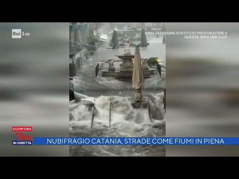
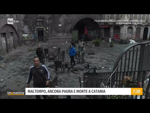
Overstromingen op het Zuid-Italiaanse eiland Sicilië hebben minstens twee slachtoffers geëist. De hulpdiensten zoeken nog naar een vermiste vrouw. In de zwaar getroffen stad Catania veranderden de straten en pleinen dinsdag in kolkende rivieren.
Het zuiden van Italië kampt al drie dagen met hevige regenval en storm, waardoor de wegen in het oosten van Sicilië onder water zijn komen te staan. De Italiaanse autoriteiten gaven maandag en dinsdag weerwaarschuwing code rood uit voor delen van Sicilië en de nabijgelegen regio Calabrië. Weersvoorspellers zeggen dat het noodweer komt door een zeldzame Mediterraanse orkaan, wat een ‘medicane’ wordt genoemd.
Op verschillende plaatsen in de regio is sinds zondag meer dan een halve meter regen gevallen. Catania noteerde dinsdag 167 millimeter regen binnen één etmaal, meer dan twee keer zoveel als normaal in de hele maand oktober. Volgens de Italiaanse krant La Repubblica moest het ziekenhuis in de havenstad worden geëvacueerd. Op verschillende video’s is te zien hoe het water op hoge snelheid door de straten stroomt en bussen en auto’s meesleept.


Zo te zien meer noodweer onderweg vandaag voor Italie
https://www.estofex.org/


https://www.estofex.org/
quote:A level 2 was issued across southern Sicily, southern Ionian Sea, Tyrrhenian Sea, and Sardinia for extreme rainfall.
A level 1 was issued across the Ionian and Tyrrhenian Sea region for extreme rainfall and to a lesser extent tornadoes.
quote:Ionian Sea, Tyrrhenian Sea, southern Italy and Sardinia and Corsica
Heavy rain is expected during the period due to ongoing thunderstorm activity in a moist, almost saturated air mass. One focus will be a convergence zone across the Tyrrhenian Sea, with a moist easterly low-level flow to the east that partly spreads upslope across Sardinia and Corsica. Thunderstorm activity is forecast to be centered in the southern parts of the area, where steeper mid-level lapse rates and lower equilibrium level temperature are forecast.
South of Italy, the subtropical storm is expected to move northward. Models indicate that MLCAPE will increase to the east and south of this storm and clusters of thunderstorms are forecast, whereas weak lightning activity is likely close to the center, where CAPE is low. Main threat is extreme rainfall, also due to deep warm clouds within the south-easterly low-level flow that enters the storm. Additionally, tornadoes are not ruled out due to strong low-level vertical wind shear. The potential threat will likely continue on Friday.
|
|