WKN Weer, Klimaat en Natuurrampen
Lees alles over het onstuimige weer op onze planeet, volg orkanen en tornado's, zie hoe vulkanen uitbarsten en hoe Moeder Aarde beeft bij een aardbeving. Alles over de verwoestende kracht van onze planeet en tal van andere natuurverschijnselen.


Gonzalo op weg naar Caraïbische Eilanden
Gonzalo to Strengthen as it Moves Toward Lesser Antilles; 91L May be a Storm Near Texas this Weekend
Na de Caribische eilanden, duikt Gonzalo de Caribische zee in. HWRF laat het systeem richting Dominicaanse republiek/Haïti en Jamaica trekken. De precieze koers en sterkte van het systeem is nog onzeker.
Zie ook: WKN / [ACTUEEL] Hurricane Season 2020: Eindelijk een rustig jaar of niet?
Gonzalo to Strengthen as it Moves Toward Lesser Antilles; 91L May be a Storm Near Texas this Weekend
quote:De afgelopen dagen heeft tropische storm Gonzalo zich gevormd boven het centrale deel van de Atlantische Oceaan. De komende dagen trekt de tropische storm westwaarts richting de Caraïbische Zee. Vooral de Bovenwindse Eilanden kunnen met Gonzalo te maken krijgen.
Gonzalo wordt waarschijnlijk de eerste Atlantische tropische storm van dit jaar die orkaankracht weet te bereiken. De vorige zes tropische stormen werden niet sterk genoeg. Naast veel wind maken de zuidelijke Bovenwindse Eilanden ook kans op hoge golven en wateroverlast door stormvloed en/of hevige regenval. Volgens de laatste berekeningen bereikt Gonzalo zondagochtend vroeg Nederlandse tijd de zuidelijke Bovenwindse Eilanden.
https://www.weerplaza.nl/(...)-cara%C3%AFben/6377/

Na de Caribische eilanden, duikt Gonzalo de Caribische zee in. HWRF laat het systeem richting Dominicaanse republiek/Haïti en Jamaica trekken. De precieze koers en sterkte van het systeem is nog onzeker.

Zie ook: WKN / [ACTUEEL] Hurricane Season 2020: Eindelijk een rustig jaar of niet?

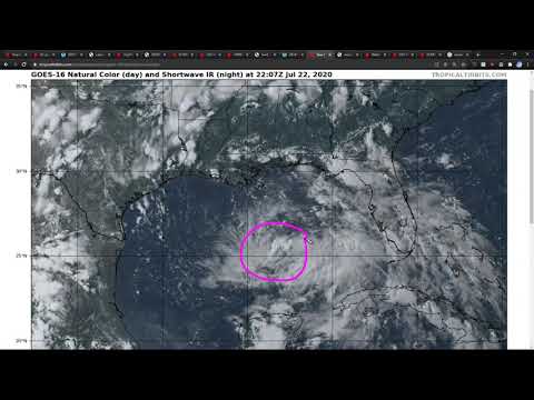
Early on July 20, the NHC began monitoring a tropical wave over the central tropical Atlantic for possible tropical cyclone development.[114] The wave moved generally westward steered by a low to mid level subtropical ridge over warm sea-surface temperatures that day, gradually getting better organized. Though in an area of only somewhat conducive conditions,[115] the wave rapidly became better organized. By 21:00 UTC July 21, satellite imagery and scatterometer data indicated that the small low pressure system had acquired a well-defined circulation as well as sufficiently organized convection to be designated Tropical Depression Seven.[116] At 12:50 UTC on July 22, the NHC issued an update upgrading the depression to Tropical Storm Gonzalo.[117] Gonzalo continued to intensify throughout the day, with an eyewall under a central dense overcast and hints of a developing eye becoming evident.[118] Gonzalo would then reach wind speeds of 60 mph at 03:00 UTC the next day.[119] At this point, Gonzalo had an unusually small wind field, with gale-force winds stretching only 35 miles from the center.[120]
Gonzalo is the earliest seventh named tropical cyclone to form in the Atlantic basin. The previous holder of this distinction was Tropical Storm Gert, which formed on July 24 during the hyperactive 2005 season.[121]
Current storm information
As of 5:00 a.m. AST (09:00 UTC) July 23, Tropical Storm Gonzalo is located within 20 nautical miles of 10.0°N 47.0°W, about 970 miles (1,565 km) east of the Southern Windward Islands. Maximum sustained winds are 55 knots (65 mph; 100 km/h), with gusts up to 65 knots (75 mph; 120 km/h). The minimum barometric pressure is 997 mbar (29.44 inHg), and the system is moving west at 10 knots (12 mph; 19 km/h). Tropical-storm-force winds extend outward up to 35 miles (55 km) from the center of Gonzalo.


quote:Hurricane Watches are currently in effect for Barbados
and St. Vincent and the Grenadines, and additional watches for
other islands could be required later today.

Zit je in de buurt?quote:Op donderdag 23 juli 2020 16:58 schreef devzero het volgende:
Een duimpje voor dit topicEven in de gaten houden en zien of ik last ga krijgen van Gonzalo.
 Op
Op
Florida gaat waarschijnlijk geen last van deze storm krijgen. Maar misschien wel een volgende, die Florida aan gaat doen. Volgende wave zit meer noordelijk.

|
|