WKN Weer, Klimaat en Natuurrampen
Lees alles over het onstuimige weer op onze planeet, volg orkanen en tornado's, zie hoe vulkanen uitbarsten en hoe Moeder Aarde beeft bij een aardbeving. Alles over de verwoestende kracht van onze planeet en tal van andere natuurverschijnselen.


Noodtoestand Golfkust VS om noodweer
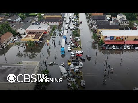
De Amerikaanse Golfkust kampt met noodweer. De stad New Orleans is al deels ondergelopen door zware regenval en voor de staten Texas, Louisiana en Mississippi komt daar mogelijk later deze week nog een orkaan bij.
De gouverneur van Louisiana heeft de noodtoestand uitgeroepen om hulpverlening te vergemakkelijken. Sommige bewoners wordt aangeraden het hogerop te zoeken, voor wie dat niet geldt luidt het advies voldoende proviand in te slaan en thuis te blijven. "Niemand moet deze storm onderschatten."
De Mississippi-rivier die door het laaggelegen New Orleans stroomt staat al hoger vanwege de 15 centimeter regen die gisteren viel. Door de storm kan het waterpeil opgestuwd worden tot 6 meter hoger dan normaal. De autoriteiten houden de dijken rond de stad in de gaten of ze niet overstromen.
Katrina
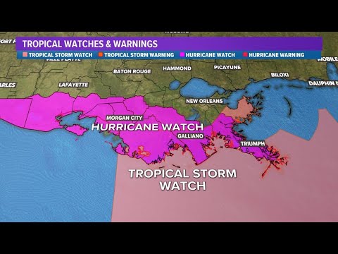
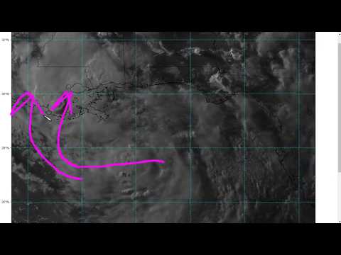
Het noodweer boven de Golf van Mexico gaat vanavond misschien over in een tropische storm. Tegen vrijdag kan die storm zijn uitgegroeid tot een orkaan van de laagste klasse. Die kan zaterdag aan land komen, als eerste orkaan van dit seizoen.
New Orleans had in het verleden vaker te kampen met grote overstromingen. In 2005 raakte de stad totaal ontregeld door orkaan Katrina. Honderden mensen kwamen daarbij om het leven, ruim 130.000 mensen vluchtten. Ook vorig jaar werd de stad nog getroffen door overstromingen.
https://nos.nl/artikel/22(...)-vs-om-noodweer.html
New Orleans is already flooded — and the worst may be yet to come: Forecasters are predicting a hurricane
De Amerikaanse Golfkust kampt met noodweer. De stad New Orleans is al deels ondergelopen door zware regenval en voor de staten Texas, Louisiana en Mississippi komt daar mogelijk later deze week nog een orkaan bij.
De gouverneur van Louisiana heeft de noodtoestand uitgeroepen om hulpverlening te vergemakkelijken. Sommige bewoners wordt aangeraden het hogerop te zoeken, voor wie dat niet geldt luidt het advies voldoende proviand in te slaan en thuis te blijven. "Niemand moet deze storm onderschatten."
De Mississippi-rivier die door het laaggelegen New Orleans stroomt staat al hoger vanwege de 15 centimeter regen die gisteren viel. Door de storm kan het waterpeil opgestuwd worden tot 6 meter hoger dan normaal. De autoriteiten houden de dijken rond de stad in de gaten of ze niet overstromen.
Katrina
Het noodweer boven de Golf van Mexico gaat vanavond misschien over in een tropische storm. Tegen vrijdag kan die storm zijn uitgegroeid tot een orkaan van de laagste klasse. Die kan zaterdag aan land komen, als eerste orkaan van dit seizoen.
New Orleans had in het verleden vaker te kampen met grote overstromingen. In 2005 raakte de stad totaal ontregeld door orkaan Katrina. Honderden mensen kwamen daarbij om het leven, ruim 130.000 mensen vluchtten. Ook vorig jaar werd de stad nog getroffen door overstromingen.
https://nos.nl/artikel/22(...)-vs-om-noodweer.html

New Orleans is already flooded — and the worst may be yet to come: Forecasters are predicting a hurricane
quote:New Orleans is prepping for a hurricane. The flooding has already hit.
On the same day that a National Oceanographic and Atmospheric Administration report warned Americans of a "floodier" future, some streets in Louisiana's largest city, including in the famed French Quarter, looked more like rivers.
Lines of thunderstorms associated with a weather system that is predicted to develop into a hurricane by Friday struck New Orleans with as much as 7 inches of rain within a three-hour period Wednesday morning, forecasters said.
The city was engulfed with water, leaving residents to contend with swampy streets, overturned garbage cans and flooded vehicles. Some even paddled their way down the street in kayaks.
Chandris Rethmeyer said she lost her car to the flood and had to wade through water about 4 feet deep to get to safety.
Rethmeyer said she was on her way home after working an overnight shift when she got stuck behind a car accident in an underpass and the water began to rise.
https://eu.usatoday.com/s(...)e-on-way/1699836001/


twitter:BillKarins twitterde op donderdag 11-07-2019 om 12:11:59 Red dots show where levees in #NewOrleans are under 20 feet. This is where over-topping of levees is most likely if the forecast of 20' comes to fruition Saturday. Red dots on north side of Mississippi River flooded during Katrina, including Lower 9th Ward. @NBCNews @MSNBC https://t.co/y5u4OR1p6V reageer retweet
 Red dots show where levees in
twitter:whatdoweseehere twitterde op donderdag 11-07-2019 om 13:02:57 An extremely rare day 3 High Risk issuance— only used for two other events (Harvey and Florence). RT @NWSWPC: A HIGH risk is in effect in our Day 3 Excessive Rainfall Outlook. More details: https://t.co/BA7ReCw1ao https://t.co/EQ29xVTIOu reageer retweet
 An extremely rare day 3 High Risk issuance— only used for two other events (Harvey and Florence). RT @

Eerst maar een TS worden... duurt langer dan ik dachtquote:Op donderdag 11 juli 2019 16:23 schreef aloa het volgende:
Volgens de laatste hwrf gaat deze orkaan als een cat 2 bij New Orleans aan land.

Kan snel gaan in de Golf. Aan de temperatuur van het water zal het niet liggen. Ruim 30 graden momenteel.quote:Op donderdag 11 juli 2019 16:28 schreef Frutsel het volgende:
[..]
Eerst maar een TS worden... duurt langer dan ik dacht
En genoeg vocht aanwezig.


Van bijna dood tot olympiër:

Flash floods incoming dus.quote:
Van bijna dood op weg naar de Olympische Spelen, tot olympiër in 2026? Elk beetje hulp wordt bijzonder gewaardeerd!
https://www.gofundme.com/(...)he-spelen-na-ongeval
https://www.gofundme.com/(...)he-spelen-na-ongeval
Van bijna dood tot olympiër:
Zal ook wel razendsnel voorbij trekken allemaal.quote:
Van bijna dood op weg naar de Olympische Spelen, tot olympiër in 2026? Elk beetje hulp wordt bijzonder gewaardeerd!
https://www.gofundme.com/(...)he-spelen-na-ongeval
https://www.gofundme.com/(...)he-spelen-na-ongeval
Dat zou het beste scenario zijn.quote:Op donderdag 11 juli 2019 19:05 schreef heywoodu het volgende:
[..]
Zal ook wel razendsnel voorbij trekken allemaal.
quote:Tropical Storm Barry Advisory Number 12
NWS National Hurricane Center Miami FL AL022019
400 AM CDT Sat Jul 13 2019
...RAINBANDS OF BARRY BEGINNING TO MOVE ONSHORE...
...DANGEROUS STORM SURGE, HEAVY RAINS, AND WIND CONDITIONS
EXPECTED ACROSS THE NORTH-CENTRAL GULF COAST...
SUMMARY OF 400 AM CDT...0900 UTC...INFORMATION
----------------------------------------------
LOCATION...29.1N 91.8W
ABOUT 55 MI...90 KM SW OF MORGAN CITY LOUISIANA
ABOUT 165 MI...260 KM W OF THE MOUTH OF THE MISSISSIPPI RIVER
MAXIMUM SUSTAINED WINDS...65 MPH...100 KM/H
PRESENT MOVEMENT...WNW OR 300 DEGREES AT 5 MPH...7 KM/H
MINIMUM CENTRAL PRESSURE...993 MB...29.33 INCHES


twitter:Jake_WPMI twitterde op vrijdag 12-07-2019 om 22:35:52 Take a look 👀 this image from Ronnie Fontenot 🌀 Barry bashing the oil rigs in the Gulf! @spann @StormHour @ThePhotoHour @PhotographyWx https://t.co/a4tCG4CRfc reageer retweet
 Take a look 👀 this image from Ronnie Fontenot 🌀 Barry bashing the oil rigs in the Gulf! @
De boel gaat wel overstromen daar.quote:
Ik ben benieuwd of hun dijken het daar nu wel gaan houden.

Tienduizenden Amerikanen zonder elektriciteit door tropische storm Barry
Tienduizenden mensen in de Amerikaanse staat Louisiana zitten zonder stroom als gevolg van de tropische storm Barry, die naar verwachting later op zaterdag aan land komt.
Door de hevige regen zitten al zo'n 56.000 woningen en bedrijfspanden zonder elektriciteit. De storm met windsnelheden van tot 100 kilometer per uur kan zich mogelijk tot een orkaan ontwikkelen, aldus de nationale weerdienst.
Meteorologen waarschuwen dat lokaal tot 60 centimeter regen kan vallen. Gevreesd wordt dat de rivier Mississippi, waarvan het waterpeil al erg hoog is na zware regenval op woensdag, zal overstromen.
Onder meer in de kustplaats New Orleans, in het zuidoosten van Louisiana, hebben inwoners zich voorbereid op storm Barry. Een aantal wijken in het zuiden van de stad zijn geëvacueerd.
De autoriteiten hebben mensen opgeroepen hun huizen te beschermen, extra eten en drinken te halen en binnen te schuilen. De Amerikaanse president Donald Trump heeft de noodtoestand voor Louisiana uitgeroepen, waardoor indien nodig gebruik kan worden gemaakt van extra hulpdiensten.
https://www.nu.nl/buitenl(...)che-storm-barry.html
Officieel een orkaan nu.
...BARRY BECOMES A HURRICANE AS IT IS MOVING ONTO THE LOUISIANA COAST... ...DANGEROUS STORM SURGE, HEAVY RAINS, AND WIND CONDITIONS OCCURRING ACROSS THE NORTH-CENTRAL GULF COAST...
...BARRY BECOMES A HURRICANE AS IT IS MOVING ONTO THE LOUISIANA COAST... ...DANGEROUS STORM SURGE, HEAVY RAINS, AND WIND CONDITIONS OCCURRING ACROSS THE NORTH-CENTRAL GULF COAST...
Dijken langs de Mississippi houden stand tijdens storm
De tropische storm die over Louisiana in het zuiden van de VS trekt, lijkt niet zo'n verwoestend effect te hebben als werd gevreesd. Storm Barry kwam als orkaan van de eerste categorie, de minst zware op een schaal van vijf, en is afgezwakt tot een tropische storm.
Verwacht werd dat er door storm Barry in de stad New Orleans zo'n 600 millimeter regen kon vallen. Gisteren viel het mee: het regende, maar de zon kwam ook af en toe door. Voor vandaag wordt 50 tot 100 millimeter verwacht.
Voor New Orleans zijn de waarschuwingen inmiddels ingetrokken. Voor andere steden die meer naar het westen langs de kustlijn liggen, blijft de waarschuwing nog wel van kracht.
Mississippi staat hoog
De afgelopen dagen werd vooral de rivier Mississippi in de gaten gehouden. Door de vele regen van de afgelopen maanden, stond het water al drie meter hoger dan normaal. Door de storm zou het water nog verder kunnen worden opgestuwd. Uiteindelijk hebben alle belangrijkste dijken langs de Mississippi het gehouden.
Volgens het Amerikaanse Nationale Orkaan Centrum is het nog steeds mogelijk dat regen tot overstromingen leidt. De gouverneur van Louisiana roept de inwoners dan ook op om waakzaam te blijven. "De storm heeft nog een lange weg te gaan voor hij de staat verlaat."
Elektriciteit uitgevallen
Op veel laaggelegen plekken zijn wel wegen ondergelopen. Ook zijn er landverschuivingen en zitten meer dan 140.000 mensen zonder stroom.
Vannacht werd nog een poging om een gezin uit z'n huis te evacueren gestaakt, omdat een reddingsactie door het hoge water te gevaarlijk was.
https://nos.nl/artikel/22(...)d-tijdens-storm.html
Alle Waffle House's zijn in Louisiana open. Waffle House heeft volgens mij een goede reputatie op het gebied van risico-analyse in extreem weer.
Ze moeten ook altijd mij hebben
|
|