WKN Weer, Klimaat en Natuurrampen
Lees alles over het onstuimige weer op onze planeet, volg orkanen en tornado's, zie hoe vulkanen uitbarsten en hoe Moeder Aarde beeft bij een aardbeving. Alles over de verwoestende kracht van onze planeet en tal van andere natuurverschijnselen.


Voorgaande topics
Topicreeks: Aardbevingen
Samenvatting
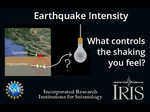
Een aardbeving is een trilling of schokkende beweging van de aardkorst. Aardbevingen vinden plaats als er in de aardkorst plotseling veel energie vrijkomt. De energie plant zich dan in een golfbeweging vanuit het centrum naar de omgeving voort. Het denkbeeldige punt waar de beving ontstaat, het zwaartepunt van de energiedichtheid, heet het hypocentrum. Het punt aan het aardoppervlak daar loodrecht boven wordt het epicentrum genoemd. Een lijn van gelijke bevingintensiteit rond een epicentrum heet een isoseist. Seismologie is de wetenschap van aardbevingen.
De meeste aardbevingen komen voor in de aardkorst tot op een diepte van ongeveer 30 kilometer. Er komen echter ook bevingen voor op dieptes tot ongeveer 700 kilometer. De meeste aardbevingen komen voor rondom de Grote Oceaan, in het Middellandse Zeegebied, in de Himalaya en Indonesi�. Ook midden in oceanen komen bevingen voor. Aardbevingen die ontstaan onder de zeespiegel worden, minder correct, ook wel zeebevingen genoemd; een vloedgolf of tsunami kan dan het gevolg zijn. Bij aardbevingen is het zo dat 'hoe ondieper een beving des te groter de kans op schade of een tsunami'.
Veel aardbevingen hangen samen met de langzame interne bewegingen van de aardkorst. Op grote schaal kan het de aardschollen betreffen, die langzaam ten opzichte van elkaar bewegen (platentektoniek). Op kleinere schaal vindt er ook binnen de platen deformatie plaats.
Door deze relatieve beweging wordt spanning opgebouwd in de korst. Als de spanning hoog genoeg is kan er een schoksgewijze beweging van het materiaal aan weerszijden van een breuk in de korst optreden: de aardbeving. Hierbij wordt (een deel van) de opgebouwde spanning ontladen. Naschokken zijn kleinere bevingen die binnen enkele uren na de eerste beving voelbaar zijn. Deze zijn vaak het gevolg van spanningsontlading op andere, nabijgelegen delen van dezelfde breuk of op andere nabije breuken. Dit type aardbevingen komt binnen platen voor tot een diepte van enkele tientallen kilometers en aan plaatranden ook tot op grotere diepte.
Aardbevingen op dieptes van enkele honderden kilometers worden vaak toegeschreven aan andere mechanismen. Ten eerste kunnen deze worden veroorzaakt in een subducerende plaat door de overgang van mineralen van een fase naar de andere (zie convectie in de aarde). Wanneer de oude fase metastabiel was, kan de overgang naar de nieuwe fase zeer plotseling zijn. Op een vergelijkbare wijze kan het plotseling loslaten van water uit waterhoudende mineralen in de subducerende plaat een aardbeving veroorzaken.
Kleine aardbevingen zijn het gevolg van vulkanische activiteit (vulkanische aardbevingen) of ontstaan door instorting van holtes in kalksteenformaties of mijnen (instortingsbevingen). Mogelijke andere oorzaken zijn ondergrondse kernproeven en meteorietinslagen.
Menselijk ingrijpen kan bevingen veroorzaken. De bodemdaling door de winning van aardgas brengt aardschokken teweeg. Dit fenomeen doet zich onder meer voor in de provincie Groningen bij het dorp Loppersum.
Hoe ontstaan ze?
Een aardbeving is een trilling of schokkende beweging van de aardkorst. Aardbevingen worden veroorzaakt als er ergens in de aardkorst plotseling veel energie vrijkomt. Dit kan door bijvoorbeeld het langs elkaar heen schuiven van de aardschollen. (Platentektoniek genoemd) Of doordat aardschollen onder/over elkaar schuiven met brute kracht. De wrijving/spanning veroorzaakt dan een breuk/aardbeving.
Breuklijnen, Aardschollen
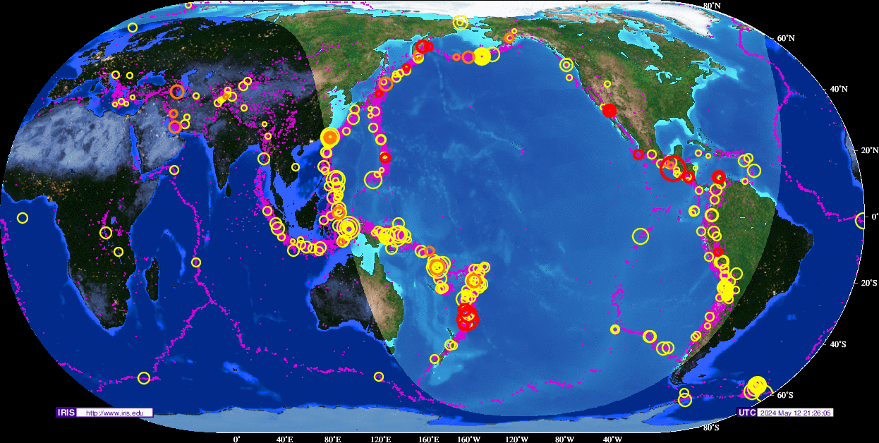
Op onderstaand plaatje kun je zien waar ter wereld de 'aardschollen' liggen. Op de grens van twee schollen komen dan ook de meeste aardbevingen ter wereld voor.

E�n van de bekendste breuken ter wereld is de San Andreas Faultline (=breuklijn) in Californie. Deze is ontstaan doordat de Pacifische Plaat langzaam langs/onder de Noord Amerikaanse plaat schuift.

Hoe worden ze gemeten?
Aardbevingen komen meestal voor op een diepte tussen de 0 en 30 km. Maar ze kunnen ook op 600 km diepte voorkomen. Het punt aan de aardkorst oppervlakte dat loodrecht boven de plek van de beving staat noemen we het "epicentrum" De bevingen worden in kaart gebracht mbv de "Schaal van Richter (Vernoemd naar de geoloog Francis Richter uit 1935).
De Richter schaal wordt gebruikt om de kracht van een aardbeving aan te geven. Het gaat daarbij om de hoeveelheid energie de vrijkomt tijdens de aardbeving. Op de Richter schaal wordt de kracht aangegeven met een getal. De Schaal van Richter is logaritmisch, dat wil zeggen dat de kracht van de aardbeving 10 keer zo groot is als het Richter getal met 1 toeneemt. Een aardbeving met kracht 6 is dus 10 keer zo zwaar als een aardbeving met kracht 5. Meer info over de richterschaal vind je o.a. in onderstaande links.
De twintig zwaarste aardbevingen sinds 1900 zijn:

De aardbeving die de meeste slachtoffers kostte was overigens veel lichter. In 1976 deed zich in China een aardbeving voor met een kracht van 8.0. Omdat het een zeer dicht bevolkt gebied was waren er ongeveer 250.000 doden te betreuren. Op 26 december 2004 vond een aardbeving plaats voor de kust van het Indonesische eiland Sumatra. Deze zeebeving had een kracht van 9.0 op de schaal van Richter. Er vielen echter slachtoffers in de hele regio Zuid-Oost Azi� (India, Sri Lanka, Thailand, Indonesi� zelf) als gevolg van de tsunami (vloedgolf) die volgde op de zeebeving. Waarschijnlijk zijn daar ook 200.000 slachtoffers gevallen. Zeer recent, in januari 2010, zorgde een beving van 7.0 voor meer dan 220.000 slachtoffers in Haïti. In mei 2008 vielen er in de Chinese provincie Sichuan ruim 65.000 doden bij een beving van 8.0. In 2003 vielen bij een aardbeving in Iran meer dan 40.000 doden bij een beving in Bam van 6.2, terwijl in 1999 ruim 44.000 mensen de dood vonden bij een beving in Turkije.
Aardbevingen? Ook in Nederland?
Ook in Nederland komen aardbevingen voor. In het zuidoosten worden elk jaar kleine aardbevingen gemeten met een kracht van 2 tot 3 op de schaal van Richter. Soms zijn er sterkere aardbevingen, zoals op 13 april 1992 in de buurt van Roermond met een kracht van 5.8 en in 2002 iets ten oosten van Roermond in Duitsland met een kracht van 4.9.
In Noord-Nederland komen, vooral in Groningen en Drenthe, lichte aardbevingen voor. Die worden naar alle waarschijnlijkheid veroorzaakt door de gaswinning uit de bodem, waardoor de aardbodem zakt. Op 24 oktober 2003 was er in de omgeving van Loppersum een lichte aardbeving met een kracht van 3.0. Het verslag van het KNMI over deze aardbeving vind je hier. In diezelfde omgeving vond ook op 22 september 2003 een (lichtere) aardbeving plaats, kracht 2.3.
Hoeveel aardbevingen vinden er plaats?
Het gemiddeld aantal bevingen per jaar met de bijbehorende magnitude (kracht) zijn:
-3000 met magnitude 5.0-5.9
-100 met magnitude 6.0-6.9
-18 met magnitude 7.0-7.9
-1 met magnitude 8.0 of meer
• Dit plaatje geeft weer waar er aardbevingen zijn geweest tussen 1963 en 1998.
• Dit plaatje geeft weer waar er aardbevingen zijn geweest tussen 1978 en 1987.
Filmpje: Aardbevingskracht in vergelijking tot Aardbevingsintensiviteit
Tsunami's - een gevolg van een zeebeving
Sinds de catastrofale zeebeving op 2e kerstdag 2004 is het woord 'tsunami' niet meer weg te denken uit de woordenboeken. Wat is nou een Tsunami?
Alle gebeurtenissen waarmee een grote hoeveelheid water in korte tijd wordt verplaatst kunnen een tsunami veroorzaken. Vloedgolven kunnen veroorzaakt worden door een zeebeving, een aardbeving waarvan het epicentrum onder de zeespiegel ligt, door een meteoriet, of door een vulkanische uitbarsting onder zee of vlak aan zee, vooral als daarbij door een grote aardverschuiving veel gesteente de zee in schuift. Ook bij plotseling afkalven van een gletsjer of ijsberg kan een vloedgolf ontstaan. Ook kan het zo zijn dat er grote stukken land of gebergte het water invallen. Hierdoor ontstaan vaak kleinere tsunami's omdat er minder water wordt verplaatst.
De meeste tsunami's komen voor rondom de Grote Oceaan, omdat langs de randen daarvan door de platentektoniek de meeste aardbevingen plaatsvinden.

Verloop van de tsunami in 2004
Door de verplaatsing van de zeebodem, vooral als deze kilometers diep plaatsvindt, wordt een enorme kolom water opgetild. Aan het wateroppervlak is daarvan weinig te zien, er ontstaat een golf van misschien een hoogte van enkele decimeters, met een enorme golflengte van 100 tot 400 kilometer. Door deze grote golflengte zijn er op volle zee maar enkele pieken en dalen merkbaar; op een schip zal de tsunami ongemerkt voorbij gaan. Een golf die door de wind wordt veroorzaakt kan weliswaar een veel grotere hoogte bereiken, tot 10 meter, bij een golflengte van 200 meter, maar de energie die in de tsunami is opgeslagen is veel groter. De waterbeweging vindt bij een tsunami plaats tot op de zeebodem, terwijl een golf door de wind slechts aan het oppervlak van de zee te merken is. Een normale golf bereikt een snelheid tot 40 km/uur, maar een tsunami kan zich met een veel hogere snelheid verplaatsen. De periode van de tsunami (het tijdsverloop tussen twee toppen) bedraagt een kwartier tot een uur.
Wat is GEE?
GEE betekent Global Earthquake Explorer. Het is een programma voor je desktop waar je live aardbevingen en data mee ontvangt.
• Developer page
• Download GEE
• Screenshots
Naslagwerken / Informatie / Nuttige Links / Sites
Aardbevingen
• Nederlandse Aardbevingsite
• US Geological Survey Website
• WikiPedia Aardbeving
• Natuurrampen pagina
• Europese (realtime) Aardbevingen
• Earthquake - Report
• Aardbevingsdossier Kennislink
• Aardbevingen, overzicht, hoe en waarom
• Earthquake calculator
Tsunami's
• Waterstanden bij boeien overal ter wereld
• WikiPedia Tsunami
• Tsunamidossier Kennislink
Deze OP is te vinden in de FOK!Wiki:
Fok!Wiki OP/Aardbevingen
Nogmaals (herhaling van de laatste post uit het vorige deel):
quote:Op donderdag 25 januari 2018 12:18 schreef Infection het volgende:
Het is erg onrustig rond de pacifische plaat. Zou me niets verbazen als ze een gigantische aardbeving gaan krijgen binnenkort.
Het lijkt mij dat die van Alaska voor meer bewegingsruimte elders langs de plaat gezorgd heeft, waardoor de andere aardbevingen optreden als een soort cascade-effect.quote:
[..]
Die bij Alaska kun je gerust gigantisch noemen
Tja, dat laatste is echter nooit bewezen dat het zo werkt. Maar het zou kunnen.quote:
Nogmaals (herhaling van de laatste post uit het vorige deel):
[..]
[..]
Het lijkt mij dat die van Alaska voor meer bewegingsruimte elders langs de plaat gezorgd heeft, waardoor de andere aardbevingen optreden als een soort cascade-effect.
quote:Magnitude Mw 6.1
Region HINDU KUSH REGION, AFGHANISTAN
Date time 2018-01-31 07:06:59.7 UTC
Location 36.55 N ; 70.87 E
Depth 189 km
Distances 272 km NE of Kabul, Afghanistan / pop: 3,044,000 / local time: 11:36:59.7 2018-01-31
68 km S of Fayzabad, Afghanistan / pop: 44,500 / local time: 11:36:59.7 2018-01-31
35 km S of Jarm, Afghanistan / pop: 12,200 / local time: 11:36:59.7 2018-01-31

6.1 Afghanistan
Superbloodmoon hits!
Zelfs vandaag weer een aardbeving in Nederland in Siddeburen van 1,8. 1,6
http://www.knmi.nl/nederland-nu/seismologie/aardbevingen
[ Bericht 5% gewijzigd door CyberCow op 31-01-2018 15:27:40 (Bijgesteld op momenten van posten) ]
http://www.knmi.nl/nederland-nu/seismologie/aardbevingen
[ Bericht 5% gewijzigd door CyberCow op 31-01-2018 15:27:40 (Bijgesteld op momenten van posten) ]
Weer aardbeving bij Vorarlberg in Oostenrijk... Dit keer van 4.0
Twee weken terug ook al een 4.2 daar.
Hopelijk triggert zoiets geen lawines daar.
Twee weken terug ook al een 4.2 daar.

Hopelijk triggert zoiets geen lawines daar.

Anderhalve maand geleden was ik nog bij Arosa, het komt wel heel dichtbij zo.quote:
Weer aardbeving bij Vorarlberg in Oostenrijk... Dit keer van 4.0
Twee weken terug ook al een 4.2 daar.
[ afbeelding ]
Hopelijk triggert zoiets geen lawines daar.

jij komt zo wel dichtbij zoquote:Op donderdag 1 februari 2018 10:35 schreef heywoodu het volgende:
[..]
Anderhalve maand geleden was ik nog bij Arosa, het komt wel heel dichtbij zo.
California Is Overdue For Another Massive Earthquake, Scientists Say
The state straddles the North American and Pacific tectonic plates and is crisscrossed by the San Andreas and other active fault systems. The magnitude 7.9 earthquake that struck off Alaska's Kodiak Island on 23 January 2018 was just the latest reminder of major seismic activity along the Pacific Rim.
Tragic quakes that occurred in 2017 near the Iran-Iraq border and in central Mexico, with magnitudes of 7.3 and 7.1, respectively, are well within the range of earthquake sizes that have a high likelihood of occurring in highly populated parts of California during the next few decades.
The earthquake situation in California is actually more dire than people who aren't seismologists like myself may realize.
Although many Californians can recount experiencing an earthquake, most have never personally experienced a strong one. For major events, with magnitudes of 7 or greater, California is actually in an earthquake drought.
Multiple segments of the expansive San Andreas Fault system are now sufficiently stressed to produce large and damaging events.
The good news is that earthquake readiness is part of the state's culture, and earthquake science is advancing – including much improved simulations of large quake effects and development of an early warning system for the Pacific coast.
The last big one
California occupies a central place in the history of seismology.
The April 18, 1906 San Francisco earthquake (magnitude 7.8) was pivotal to both earthquake hazard awareness and the development of earthquake science – including the fundamental insight that earthquakes arise from faults that abruptly rupture and slip.
The San Andreas Fault slipped by as much as 20 feet (six metres) in this earthquake.
Although ground-shaking damage was severe in many places along the nearly 310-mile (500-kilometre) fault rupture, much of San Francisco was actually destroyed by the subsequent fire, due to the large number of ignition points and a breakdown in emergency services.
That scenario continues to haunt earthquake response planners. Consider what might happen if a major earthquake were to strike Los Angeles during fire season.
Seismic science
When a major earthquake occurs anywhere on the planet, modern global seismographic networks and rapid response protocols now enable scientists, emergency responders and the public to assess it quickly – typically, within tens of minutes or less – including location, magnitude, ground motion and estimated casualties and property losses.
And by studying the buildup of stresses along mapped faults, past earthquake history, and other data and modeling, we can forecast likelihoods and magnitudes of earthquakes over long time periods in California and elsewhere.
However, the interplay of stresses and faults in the Earth is dauntingly chaotic. And even with continuing advances in basic research and ever-improving data, laboratory and theoretical studies, there are no known reliable and universal precursory phenomena to suggest that the time, location and size of individual large earthquakes can be predicted.
Major earthquakes thus typically occur with no immediate warning whatsoever, and mitigating risks requires sustained readiness and resource commitments.
This can pose serious challenges, since cities and nations may thrive for many decades or longer without experiencing major earthquakes.
California's earthquake drought
The 1906 San Francisco earthquake was the last quake greater than magnitude 7 to occur on the San Andreas Fault system.
The inexorable motions of plate tectonics mean that every year, strands of the fault system accumulate stresses that correspond to a seismic slip of millimeters to centimeters. Eventually, these stresses will be released suddenly in earthquakes.
But the central-southern stretch of the San Andreas Fault has not slipped since 1857, and the southernmost segment may not have ruptured since 1680. The highly urbanized Hayward Fault in the East Bay region has not generated a major earthquake since 1868.
Reflecting this deficit, the Uniform California Earthquake Rupture Forecast estimates that there is a 93 percent probability of a 7.0 or larger earthquake occurring in the Golden State region by 2045, with the highest probabilities occurring along the San Andreas Fault system.
Can California do more?
California's population has grown more than 20-fold since the 1906 earthquake and currently is close to 40 million.
Many residents and all state emergency managers are widely engaged in earthquake readiness and planning. These preparations are among the most advanced in the world.
For the general public, preparations include participating in drills like the Great California Shakeout, held annually since 2008, and preparing for earthquakes and other natural hazards with home and car disaster kits and a family disaster plan.
No California earthquake since the 1933 Long Beach event (6.4) has killed more than 100 people. Quakes in 1971 (San Fernando, 6.7); 1989 (Loma Prieta; 6.9); 1994 (Northridge; 6.7); and 2014 (South Napa; 6.0) each caused more than US$1 billion in property damage, but fatalities in each event were, remarkably, dozens or less.
Strong and proactive implementation of seismically informed building codes and other preparations and emergency planning in California saved scores of lives in these medium-sized earthquakes. Any of them could have been disastrous in less-prepared nations.
Nonetheless, California's infrastructure, response planning and general preparedness will doubtlessly be tested when the inevitable and long-delayed "big ones" occur along the San Andreas Fault system.
Ultimate damage and casualty levels are hard to project, and hinge on the severity of associated hazards such as landslides and fires.
Several nations and regions now have or are developing earthquake early warning systems, which use early detected ground motion near a quake's origin to alert more distant populations before strong seismic shaking arrives.
This permits rapid responses that can reduce infrastructure damage. Such systems provide warning times of up to tens of seconds in the most favorable circumstances, but the notice will likely be shorter than this for many California earthquakes.
Early warning systems are operational now in Japan, Taiwan, Mexico and Romania. Systems in California and the Pacific Northwest are presently under development with early versions in operation.
Earthquake early warning is by no means a panacea for saving lives and property, but it represents a significant step toward improving earthquake safety and awareness along the West Coast.
The ConversationManaging earthquake risk requires a resilient system of social awareness, education and communications, coupled with effective short- and long-term responses and implemented within an optimally safe built environment.
As California prepares for large earthquakes after a hiatus of more than a century, the clock is ticking.
Ik wist niet dat daar aardbevingen voor komen.quote:
Weer aardbeving bij Vorarlberg in Oostenrijk... Dit keer van 4.0
Twee weken terug ook al een 4.2 daar.
[ afbeelding ]
Hopelijk triggert zoiets geen lawines daar.
Werewolf
Papa 15/11/1950 - 29/08/2025
Fring is mijn allerliefste knuffelkont
Been haunted by a million screams
Papa 15/11/1950 - 29/08/2025
Fring is mijn allerliefste knuffelkont
Been haunted by a million screams
Tsja... iedere dag komen ze dichterbij een nieuwe beving.quote:
Als je het maar lang genoeg blijft roepen, komt het vanzelf een keer uit.

Flinke schade na beving in Taiwan zojuist...

Opgeblazen gevoel of winderigheid? Zo opgelost met Rennie!
Volgens mij is dat een foto van de 1999 bevingquote:Op dinsdag 6 februari 2018 18:06 schreef Eyjafjallajoekull het volgende:
Flinke schade na beving in Taiwan zojuist...
[ afbeelding ]
Ik wist dat ik had moeten checken....quote:Op dinsdag 6 februari 2018 18:08 schreef Frutsel het volgende:
[..]
Volgens mij is dat een foto van de 1999 beving
Het voelde al zo oud aan dat gebouw, terwijl taiwan tegenwoordig best modern is.
Opgeblazen gevoel of winderigheid? Zo opgelost met Rennie!
Er schijnt wel schade te zijn aan gebouwen of een hotel trouwens. Maar denk dat deze foto niet klopt.quote:
[..]
Ik wist dat ik had moeten checken....
Het voelde al zo oud aan dat gebouw, terwijl taiwan tegenwoordig best modern is.

Wanneer scheurt westafrika van Afrika?
Crack the following and we will get back to you: !1!llssod000;;
Tis nu inderdaad veel ergerquote:
[..]
Volgens mij is dat een foto van de 1999 beving
https://nos.nl/artikel/22(...)n-na-aardbeving.htmltwitter:taiwanmag twitterde op dinsdag 06-02-2018 om 17:29:12 #séisme : immeubles effondrés à Hualien et ponts endommagés. #Taiwan https://t.co/IkK5sS7cMS reageer retweet

Crack the following and we will get back to you: !1!llssod000;;

Best bizar dat die verdiepingen/de structuur nog zo "intact" zijn/is. Je zou toch verwachten dat het hele gebouw als een kaartenhuis instort.quote:
 Op
Op
twitter:EMSC twitterde op woensdag 07-02-2018 om 17:07:55 Update: M5.8 #earthquake (#地震) strikes 112 km S of #Taipei (Chinese #Taipei) 46 min ago. https://t.co/CZ7Vu3h8Er reageer retweet
 Update: M5.8
twitter:EMSC twitterde op zaterdag 17-02-2018 om 01:00:03 #Earthquake (#sismo) M7.2 strikes 233 km E of Acapulco de Juárez (#Mexico) 20 min ago. More info: https://t.co/KYQ3WOicKF reageer retweet

twitter:EMSC twitterde op zaterdag 17-02-2018 om 15:43:34 #Earthquake (#daeargryn) M4.9 strikes 88 km W of #Bristol (United Kingdom) 12 min ago. More info: https://t.co/I12BaFaNrJ reageer retweet
twitter:LastQuake twitterde op zaterdag 17-02-2018 om 16:05:19 The mag has now been revised down to M4.7. This map represents effects reported by eyewitnesses https://t.co/MD6OlHYHM3 reageer retweet
 The mag has now been revised down to M4.7. This map represents effects reported by eyewitnesses
 [ Bericht 21% gewijzigd door Houtenbeen op 17-02-2018 16:07:38 ]
quote:
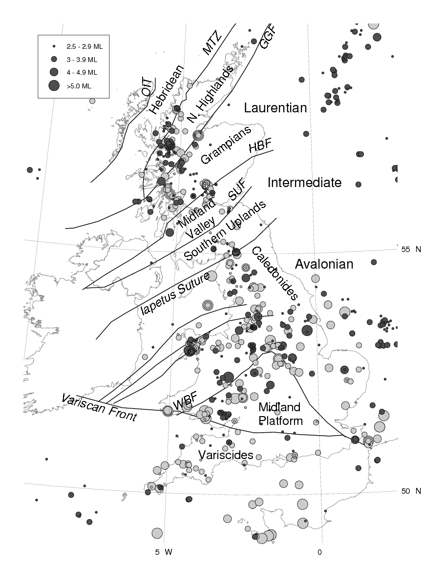
quote:Instrumental (dark grey) and historical (light gray) seismicity of the British Isles from the British Geological Survey earthquake catalogue (Musson, 1996). Earthquake symbols are scaled by magnitude. Geological terranes after Bluck et al. (1992) are also shown. Major faults corresponding to terrane boundaries are abbreviated as follows: Outer Isles Thrust (OIT); Moine Thrust (MTZ); Great Glen Fault (GGF); Highland Boundary Fault (HBF); Southern Uplands Fault (SUF); Welsh Borderland Fault System (WBF).
Mogelijk tientallen doden door aardbeving Papoea-Nieuw-Guinea (kracht 7,5)
VANDAAG, 04:31BUITENLAND
Bij een aardbeving in Papoea-Nieuw-Guinea zijn mogelijk tientallen doden gevallen. Volgens de lokale krant Post Courier wordt het dodental geschat op zeker dertig.
De beving van gisteren had een kracht van 7,5. De meeste schade is in de provincies Hela en Southern Highlands. Daar vielen volgens de lokale autoriteiten meer dan 300 gewonden. Ook raakten huizen en andere gebouwen beschadigd.
Een provinciebestuurder spreekt tegen persbureau AP van een ontwrichtende situatie. Hij zegt niet eerder zo'n grote ramp te hebben meegemaakt. Door de beving is de stroom in het gebied uitgevallen en ligt het internet en telefoonverkeer plat. Het provinciebestuur communiceert met het rampgebied via satelliettelefoons.
Er zijn meerdere naschokken geweest en de overheid verwacht die ook voor de komende dagen. De beving heeft ook sinkholes en aardverschuivingen veroorzaakt, waardoor wegen zijn afgesloten. Het vliegverkeer is ontregeld doordat op Komo Airport de helft van de start- en landingsbaan is beschadigd.
bron: https://nos.nl/artikel/22(...)ea-nieuw-guinea.html
Herman Finkers... He buurman, ik hier ?
Schade in PNG echt ongekend, gebied waar tot dusverrr zelden grote aardbevingen plaatsvonden, en nu de grootste aardbeving ooit in PNG voor zover bekend dan.
Is er stedelijk gebied geraakt?quote:
Schade in PNG echt ongekend, gebied waar tot dusverrr zelden grote aardbevingen plaatsvonden, en nu de grootste aardbeving ooit in PNG voor zover bekend dan.
edit: voornamelijk dorpen in de binnenlanden zie ik.. veel aardverschuivingen.
And what rough beast, its hour come round at last,
Slouches towards Bethlehem to be born?
Slouches towards Bethlehem to be born?
Kleine steden, maar Highlands is het gebied waar de meeste inwoners van PNG wonen, en die wonen vaak in kleine gemeenschappen in het oerwoud. Wat de schade daar is kan je alleen maar naar gissen tot dusverre. Lokale bedrijven (zitten grote mijnen en energiebedrijven waaronder Exxon overigens) hebben foto's gemaakt en die laten ongekende aardverschuivingen zien. Aarde was aan het trillen over een breedte van drie kilometer wat schijnbaar groot is in deze. Persoonlijk leed voor inwoners is groot, communicatie en contact zal moeizaam tot stand komen omdat veel gemeenschappen al redelijk afgezonderd woonden, plus se vraag is of dat echt ooit helemaal duidelijk gaat worden. Wat wel enigzins duidelijk gaat worden is de economische schade nu een paar van de grootste mijnen en energiebedrijven stilgelegd zijn en er schade is gemeld.quote:
quote:Magnitude Mw 6.6
Region NEW GUINEA, PAPUA NEW GUINEA
Date time 2018-03-06 14:13:07.4 UTC
Location 6.16 S ; 142.57 E
Depth 10 km
Distances 625 km NW of Port Moresby, Papua New Guinea / pop: 284,000 / local time: 00:13:07.4 2018-03-07
120 km W of Mendi, Papua New Guinea / pop: 26,300 / local time: 00:13:07.4 2018-03-07
104 km SW of Porgera, Papua New Guinea / pop: 1,600 / local time: 00:13:07.4 2018-03-07

Fascinerend want dat gebied wordt zelden getroffen door aardbevingen en dus al bijna helemaal niet door grote aardbevingen.
PNG wordt regelmatig getroffen door zware aardbevingen hoor. Het is misschien wel bijzonder voor dit gebied maar er loopt wel een actieve breuklijn. Sommige bevingen gaan gepaard met tsunami's zoals in 1998. Dodental loopt nu ook weer aardig opquote:
Fascinerend want dat gebied wordt zelden getroffen door aardbevingen en dus al bijna helemaal niet door grote aardbevingen.
quote:Papua New Guinea earthquake death toll reaches 67
Rescue efforts continue as aftershocks hit Southern Highlands, a week after quake
Aid workers in Papua New Guinea say the death toll from last week’s 7.5 earthquake has reached at least 67, as the country’s remote highlands were again rocked by strong aftershocks.
Three aftershocks, each stronger than magnitude 5, shook the rugged Southern Highlands early on Monday, spreading fear in a region already badly damaged when the largest quake to hit the region struck a week ago.
Aid is beginning to trickle into the worst affected regions but the extent of the devastation has taken days to emerge because of the area’s remoteness – about 500km from the capital Port Moresby.
Udaya Regmi, the head of the Red Cross office in Papua New Guinea, said the death toll was expected to keep climbing.
“We know at least 500 people are injured and 127,000 people need immediate aid such as food, water, shelter and healthcare” Regmi said.
“Many places that have been struck are still inaccessible, except by walking in, so there is a huge supply issue in delivering aid. We definitely need more help from our neighbours and the aid community, this is turning into a humanitarian crisis.”
Isaac Pulupe, a resident of Tari, in Hela Province, which bore the brunt of the quake, told Radio New Zealand that most buildings in his town of 10,000 had collapsed, including the school and part of the hospital.
“Most people have been traumatised emotionally from all that is happening and the continual earthquakes going on, their gardens and even homes have collapsed.” Pulupe said.
“We’ve heard that there are international charity organisations committed to come to help us, but we haven’t seen them yet. We only have the provincial government team trying to go around doing the assessments.”
All four regions struck by the quake remain under a state of emergency and the government has freed up emergency funding to expedite the relief effort, but major landslips, widespread cuts to power and communications and destroyed roads have made coordinating the relief effort to this remote and impoverished region exceedingly challenging.
Advertisement
Last week, the Red Cross committed several hundred thousand dollars to the earthquake relief effort, but admitted they were struggling to access the worst affected areas, as only helicopters could get in.
Ik kan je verzekeren dat het voor dit gebied uniek is, zeer uniek zelfs, het klopt dat elders in het land regelmatig aardbevingen plaatsvinden maar dat de zwaarste aardbeving in zo'n eeuw tijd, indien niet langer, juist in dit gebied plaatsvindt dat is zeer opvallend te noemen in deze situatie.quote:
[..]
PNG wordt regelmatig getroffen door zware aardbevingen hoor. Het is misschien wel bijzonder voor dit gebied maar er loopt wel een actieve breuklijn. Sommige bevingen gaan gepaard met tsunami's zoals in 1998. Dodental loopt nu ook weer aardig op
twitter:EMSC twitterde op donderdag 08-03-2018 om 19:01:20 #Earthquake M6.8 strikes 114 km E of #Kokopo (Papua New Guinea) 21 min ago. More info: https://t.co/dXyFB4vX5y reageer retweet

twitter:NewsWorldIN twitterde op maandag 26-03-2018 om 12:09:04 JUST IN: #Earthquake of 7 magnitude strikes off Papua New Guinea - USGS https://t.co/y9AciwubqY reageer retweet
 JUST IN:
twitter:SkyNewsBreak twitterde op donderdag 29-03-2018 om 23:38:51 United States Geological Survey says an earthquake with a 7.2 magnitude has struck off the coast of Papua New Guinea reageer retweet
 United States Geological Survey says an earthquake with a 7.2 magnitude has struck off the coast of Papua New Guinea
quote:Magnitude mb 4.3
Region CENTRAL ITALY
Date time 2018-04-04 02:19:46.1 UTC
Location 43.06 N ; 13.03 E
Depth 9 km
Distances 137 km N of Roma, Italy / pop: 2,564,000 / local time: 04:19:46.1 2018-04-04
53 km E of Perugia, Italy / pop: 150,000 / local time: 04:19:46.1 2018-04-04
43 km SW of Macerata, Italy / pop: 40,900 / local time: 04:19:46.1 2018-04-04

quote:5 injured after M5.8 earthquake hits Japan's Honshu, stronger quakes possible
At least five people were injured after a shallow M5.8 earthquake hit Japan's Honshu island at 16:32 UTC on April 8, 2018 (01:32 JST, April 9). JMA is reporting a depth of 10 km (6.2 miles). USGS is reporting this quake as M5.6 and EMSC as M5.7.
The epicenter was located 7.7 km (4.8 mi) NNE of Oda (population 21 285), 8.5 km (5.3 mi) NNE of Ōdachō-ōda (population 31 867), 23.6 km (14.7 mi) WSW of Izumo (population 89 286), 31.5 km (19.6 mi) SW of Hiratachō (population 28 154) and 52.4 km (32.6 mi) WSW of Matsue (population 156 811), Japan.
Some 2.4 million people are living within 100 km (62 miles) and 23 000 within 10 km.
At least 5 people were injured, including a 17-year-old boy who broke his leg after falling from his bed, the Japanese media reported.
Some 100 households lost water and 50 households were left without electricity in the city of Oda, where the government requested the dispatch of a Self-Defense Forces unit to assist in distributing water to affected residents.
Officials confirmed damage to some buildings and cracks in roads.
Although the epicenter is just 50 km (31 miles) south of Shimane nuclear power plant, the owner said there were no abnormalities found at the plant.
JMA urged residents to stay vigilant as more strong quakes are possible in the coming week or so.
"We want the areas that experienced strong tremors to be on guard in the coming week or so against quakes that could be as powerful as the upper five," JMA official Toshiyuki Matsumori said, referring to a Japanese seismic scale with a maximum intensity of seven.
Several strong tremors have already been felt in the region.
quote:Magnitude mb 4.7
Region CENTRAL ITALY
Date time 2018-04-10 03:11:31.1 UTC
Location 43.07 N ; 13.04 E
Depth 9 km
Distances 138 km N of Roma, Italy / pop: 2,564,000 / local time: 05:11:31.1 2018-04-10
53 km E of Perugia, Italy / pop: 150,000 / local time: 05:11:31.1 2018-04-10
41 km SW of Macerata, Italy / pop: 40,900 / local time: 05:11:31.1 2018-04-10

Rommelt goed door in Italië...
Nou de Amerikanen zijn weer wakker geschud daar in de LA Area...quote:You felt this earthquake. Tell us!
Magnitude Ml 4.6
Region SOUTHERN CALIFORNIA
Date time 2018-05-08 11:49:33.0 UTC
Location 34.02 N ; 116.78 W
Depth 14 km
Distances

quote:Earthquake swarm started near Comores group
A rare earthquake swarm started near the small Indian Ocean island of Mayotte on May 10, 2018 and continues to date. Mayotte is the oldest volcanic island in the Comoros Basin grouping and quakes likely are the result of a seismic hot spot as well as the island’s position along the East African Rift.
According to the BRGM, the France-based geological agency serving the territory, the swarm started at 05:14 UTC on May 10 and increased around 12:00 UTC with magnitudes close to 3.0. Magnitudes increased to 3.5 and 3.7 by 16:40 UTC on the same day.
The first quake felt by the population hit at 23:19 UTC, May 10 and had a magnitude of 4.5, according to the BRGM.
The strongest earthquake in this sequence so far was M5.1 (USGS, EMSC) registered at 14:41 UTC on May 14.