WKN Weer, Klimaat en Natuurrampen
Lees alles over het onstuimige weer op onze planeet, volg orkanen en tornado's, zie hoe vulkanen uitbarsten en hoe Moeder Aarde beeft bij een aardbeving. Alles over de verwoestende kracht van onze planeet en tal van andere natuurverschijnselen.


Seizoen is nog niet voorbij..quote:'Opluchting' op Sint-Maarten voorafgaand aan zwakkere orkaan Jose
"Het is rustig op straat", begint Gordon Snow, hoofdredacteur van de The Daily Herald op Sint-Maarten. "De mariniers hebben sommige posten al verlaten. Ik kan niet zeggen of de rust nou komt door de aanwezigheid van de mariniers of doordat iedereen zich klaarmaakt voor de komst van orkaan Jose."
Want iedereen is zich daarop aan het voorbereiden, gaat hij verder. "Er heerst hier een gevoel van opluchting dat de storm ten noorden aan ons voorbij zal gaan, dat scheelt toch een slok op een borrel. Het is fijn dat we niet nog eens de orkaanwinden hoeven mee te maken."

Lijkt heel onzeker welk pad hij neemt maar dit zou heel slecht uitkomen voor het gebied wat nu door Irma word getroffen.


Wat is dat ding links? Niet Katia lijkt me?quote:Op zondag 10 september 2017 16:50 schreef aloa het volgende:
GFS gaat nu voor de Bahamas.
[ afbeelding ]

Die moet zelfs nog ontstaan.quote:Op zondag 10 september 2017 16:51 schreef heywoodu het volgende:
[..]
Wat is dat ding links? Niet Katia lijkt me?
Is dat al een invest of hoe je dat ook noemt? Maw, hoe kan ik die volgen?quote:
Edit, hier dus:
http://www.nhc.noaa.gov/gtwo.php?basin=epac&fdays=5
Ben wel benieuwd of Jose de loop voltooid.
Als in elk geval het UKmet model gelijk gaat krijgen kunnen de Bahama's zich opmaken voor nieuwe rotzooi.
Als in elk geval het UKmet model gelijk gaat krijgen kunnen de Bahama's zich opmaken voor nieuwe rotzooi.
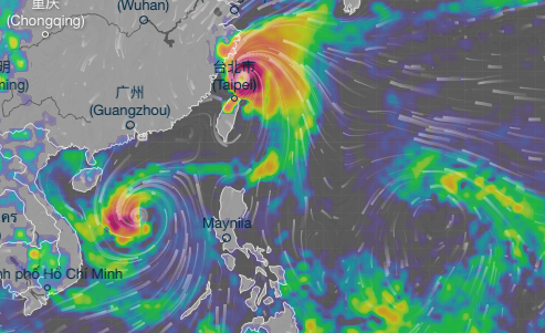
En de verwachting voor Taipei voor woensdag op donderdag onze tijd.quote:
Wat is dat ding links? Niet Katia lijkt me?
volgens mij zit je in het verkeerde topic.quote:
[..]
En de verwachting voor Taipei voor woensdag op donderdag onze tijd.
[ afbeelding ]
WKN / Hurricane Season 2017 #1: The year after El Nino
Jose lijkt nu op South of North Carolina af te gaan.. zijn er ergens voorspellingen hoe krachtig hij zal zijn na het weekend?

Alpha kenny one
Je hebt gelijk. Had beide tabbladen openstaan.quote:Op dinsdag 12 september 2017 08:45 schreef Frutsel het volgende:
volgens mij zit je in het verkeerde topic.
WKN / Hurricane Season 2017 #1: The year after El Nino
quote:Hurricane Jose Discussion Number 29
NWS National Hurricane Center Miami FL AL122017
1100 AM AST Tue Sep 12 2017
The satellite presentation of Jose is that of a rather amorphous
blob of deep convection, with only slight evidence of banding
features. The system continues to be sheared by northwesterly flow
associated with an upper-level anticyclone centered just to its
west. A value of 65 kt is retained for the current intensity, in
agreement with a Dvorak estimate from SAB. The dynamical models
indicate that the shear over Jose will remain fairly strong for the
next few days with perhaps some relaxation by days 3-5 as an
upper-level high becomes situated over the system. Thus a little
weakening in the short term, followed by some restrengthening later
in the forecast period, is expected. Confidence in this intensity
forecast is, however, lower than usual.
Although the center is difficult to locate, a blend of geostationary
and microwave fixes yield a slow eastward motion of around 090/4 kt.
Jose is currently situated in a region of weak steering currents.
The GFS and ECMWF global models build a mid-level anticyclone to the
west of the tropical cyclone in a day or two. The anticyclone is
then forecast to shift north, and then east, of Jose later in the
forecast period. This evolution of the steering flow should result
in the tropical cyclone moving in a clockwise loop over the next
several days. Aside from the U.K. Met. Office prediction, which is
well south and west of the other track models, the official forecast
is near the left side of the guidance suite.
Ik mis in dit topic de updates van users die het Amerikaanse model naast het Europese model leggen (vooral de long-term, al is dat vaak onbetrouwbaar, toch leuk om te zien).
Blijft Jose maar rondjes draaien de komende tijd of komt hij toch aan land? Zo ja met welke kracht? Ik ken persoonlijk enkel de NHC voorspelling.
Blijft Jose maar rondjes draaien de komende tijd of komt hij toch aan land? Zo ja met welke kracht? Ik ken persoonlijk enkel de NHC voorspelling.
Alpha kenny one


twitter:BillKarins twitterde op vrijdag 15-09-2017 om 11:00:21 And there is the shift west again with #Jose. Welcome to the "Cone of Uncertainty" #NYC, NJ, DE, MD, CT, RI, MA. https://t.co/Mnavpete7J reageer retweet
 And there is the shift west again with


Even los van de serieuze geaardheid. Valt mij wel op dat al die orkanen of stormen van die Spaans/Engels achtige namen hebben en ik tot nu toe geen enkele orkaan " mohammed " o.i.d. heb horen heten. Of is dal allemaal omdat men weer angstig is deze zo te benoemen en dus maar uit veiligheidsredenen het een andere naam geeft ongeacht of die bij een andere bevolkingsgroep irritatie oproept zoals in deze latino's.
Denk dat dat komt doordat de namen zijn gebaseerd op het NAVO-alfabet, die ook enkele Spaanse (of Spaans aandoende) namen bevat.
''Aquila non capit muscas.''

Ook Jose lijkt de loop te gaan maken... en dit is van grote invloed op Maria die veel verder naar het zuiden ligt
Het Fujiwara effect..
quote:Jose and Maria: To dance or not to dance?
The dance routine between Jose and Maria shown in recent model runs is known as the Fujiwara effect, explained in greater detail a few weeks ago by our newest Capital Weather Gang contributor, Matthew Cappucci. It's a rare phenomenon, especially in the Atlantic Ocean. It's also an unlikely scenario, despite the recent model trends.
At issue is the placement and scope of two upper-level areas of high pressure by next weekend (as shown below). High pressure over the central Atlantic that trapped Jose last week will begin to weaken over the next few days, before restrengthening later. Meanwhile, another area of high pressure is expected to build over Ontario by next weekend. For Jose and Maria to interact and affect each other's path, that Ontario high pressure would have to build over the top of Jose, to keep Jose from escaping out to sea. While that could happen, uncertainty remains high at this time.

[ Bericht 38% gewijzigd door Frutsel op 18-09-2017 09:43:49 ]
|
|