BNW Brave New World
Samenzwering, verborgen agenda's en geheime geschiedenis. De zoektocht naar de wereld die achter de façade van alledag ligt.


Dat is een van de zaken die de komende jaren worden onderzocht.quote:Op zaterdag 15 april 2017 11:35 schreef Papierversnipperaar het volgende:
[..]
De maan zou een mooie springplank kunnen vormen. Weinig zwaartekracht en massa's grondstoffen.
zeer vocale Trump hater - VEM2012
De ontkoppeling van de eerste trap was zo fel dat mensen het met hun bloten ogen zagen.
https://i.imgur.com/COKHuNH.mp4
Het was het zwaarste onderdeel van de lancering. De astronauten merkten het ook goed.
https://i.imgur.com/COKHuNH.mp4
Het was het zwaarste onderdeel van de lancering. De astronauten merkten het ook goed.


The difference between the three Abrahamic religions:
- Christianity mumbling to the ceiling,
- Judaism mumbling to the wall,
- Islam mumbling to the floor.
- Christianity mumbling to the ceiling,
- Judaism mumbling to the wall,
- Islam mumbling to the floor.
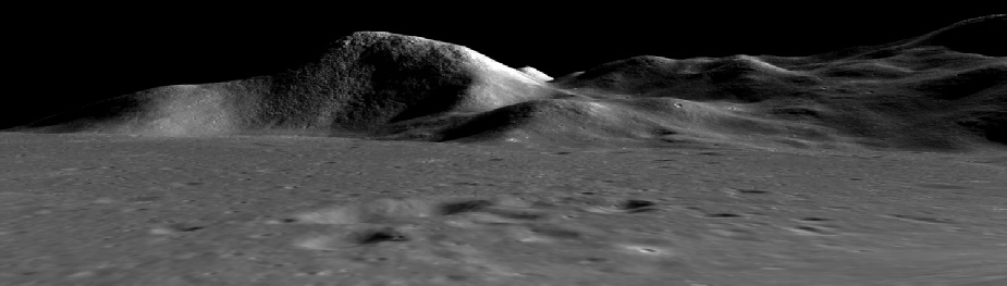
En als je alle hoogte data samenvoegd met de foto's genomen door satellieten, en die 3D renders vervolgens vergelijkt met Apollo foto's, komen hoogteverschillen overeen.
Iets wat NASA niet zo precies wist vóór Apollo missies, en dus niet hadden kunnen neppen.
Iets wat NASA niet zo precies wist vóór Apollo missies, en dus niet hadden kunnen neppen.
Amyquote:
 Op
Op
Egregious professor of Cruel and Unusual Geography
Onikaan ni ov dovah
Onikaan ni ov dovah
Ik lees nog steeds wel eens dat de AGC onmogelijk zou zijn voor die tijd.
Lulkoek, de AGC past perfect in het plaatje van snoeiharde computer ontwikkelingen toen der tijd.
Kleine computers ter grootte van een kast bestonden al. Bedrijven hadden geen behoeften aan kleineren computers. NASA had een groter budget voor computers dan bedrijven.
Verder zijn onderdelen van MiT AGC computers getest en het werkten. Zelfde met Saturn-V computers gemaakt door IBM.
En je hebt dit soort creaties:quote:Op vrijdag 21 april 2017 18:50 schreef t4600c het volgende:
Ik lees nog steeds wel eens dat de AGC onmogelijk zou zijn voor die tijd.
Lulkoek, de AGC past perfect in het plaatje van snoeiharde computer ontwikkelingen toen der tijd.
Kleine computers ter grootte van een kast bestonden al. Bedrijven hadden geen behoeften aan kleineren computers. NASA had een groter budget voor computers dan bedrijven.
Verder zijn onderdelen van MiT AGC computers getest en het werkten. Zelfde met Saturn-V computers gemaakt door IBM.

http://www.geek.com/geek-(...)ng-computer-1495169/
Egregious professor of Cruel and Unusual Geography
Onikaan ni ov dovah
Onikaan ni ov dovah
Heerlijk wijf talking geek, woofquote:
The difference between the three Abrahamic religions:
- Christianity mumbling to the ceiling,
- Judaism mumbling to the wall,
- Islam mumbling to the floor.
- Christianity mumbling to the ceiling,
- Judaism mumbling to the wall,
- Islam mumbling to the floor.


Mooie collectie, heeft je vast een aardige duit gekocht!quote:
Ze zijn er !!!!!

[ afbeelding ]
[ afbeelding ]
Koningsdag marathon wie komt?
En sorry koningsdag ben ik zoals elk jaar de rommelamrkt aan het plunderen
I am the hope of the universe. I am the answer to all living things that cry out for help.I am the protector of the innocent. I am the Light in the darkness. I am truth. Ally to good! Nightmare to you!
Joke of a Lunar Rover (5min) :
Moon Bugs (3:52) :
Apollo Lunacy (5:52) :
Zie meer korte,grappige,leuke ouwe filmpjes:
https://www.youtube.com/user/APOLLOREALITY/videos

Moon Bugs (3:52) :

Apollo Lunacy (5:52) :

Zie meer korte,grappige,leuke ouwe filmpjes:
https://www.youtube.com/user/APOLLOREALITY/videos
In the new 'reality' we will be living in,nothing will be real and everything will be true-David A.McGowan
Why do some people not credit the origin of the quotes they use under their posts?- Tingo
Why do some people not credit the origin of the quotes they use under their posts?- Tingo
Leuk, zo'n linkdump.quote:
Joke of a Lunar Rover (5min) :
Moon Bugs (3:52) :
Apollo Lunacy (5:52) :
Zie meer korte,grappige,leuke ouwe filmpjes:
https://www.youtube.com/user/APOLLOREALITY/videos
Egregious professor of Cruel and Unusual Geography
Onikaan ni ov dovah
Onikaan ni ov dovah
Gewoon grappige filmpjes.quote:
Past toch goed bij de 'artistieke representaties' of niet?
In the new 'reality' we will be living in,nothing will be real and everything will be true-David A.McGowan
Why do some people not credit the origin of the quotes they use under their posts?- Tingo
Why do some people not credit the origin of the quotes they use under their posts?- Tingo
Why would you think that?quote:
[..]
Gewoon grappige filmpjes.
Past toch goed bij de 'artistieke representaties' of niet?
Egregious professor of Cruel and Unusual Geography
Onikaan ni ov dovah
Onikaan ni ov dovah
Dus je wilt unprocessed data direct van telescopen en satelieten? zonder artistic false colour processes waar jij over klaagt.quote:
[..]
Gewoon grappige filmpjes.
Past toch goed bij de 'artistieke representaties' of niet?
Of hij snapt het niet zo goed.quote:
[..]
Dus je wilt unprocessed data direct van telescopen en satelieten? zonder artistic false colour processes waar jij over klaagt.
Egregious professor of Cruel and Unusual Geography
Onikaan ni ov dovah
Onikaan ni ov dovah
 Op
Op 
Ben al een tijdje ergens mee bezig. Recente satellieten rond de maan zijn bekent door hun bizare foto's maar ze verzamelen veel meer data. Waaronder hoogte van het maanoppervlakte.
Hoewel ze foto's hadden van het maanoppervlakte, hadden ze geen instrumenten om hoogte te meten. Ze moesten alles inschatten met schaduwen, wat op de maan veraadelijk is door haar reflectieve grond.
De wetenschappelijke data is moelijk om mee te werken, omdat het natuurlijk bedoeld is voor...wetenschappers het was dus even leren hoe alle software en bestanden werken. Er zijn niet echt tutorials voor.
Uitendelijk lukten het om 3D renders te maken door foto's en hoogte data te combineren.
Zie hier, renders van raw data direct van de respectieve websites (JAXA, india, LRO etc) (Staat allemaal online, maar is niet te openenen met normale image software omdat het veel meer data dan alleen plaatjes bevat.)
Links 3D render, rechts AS17-147-22467
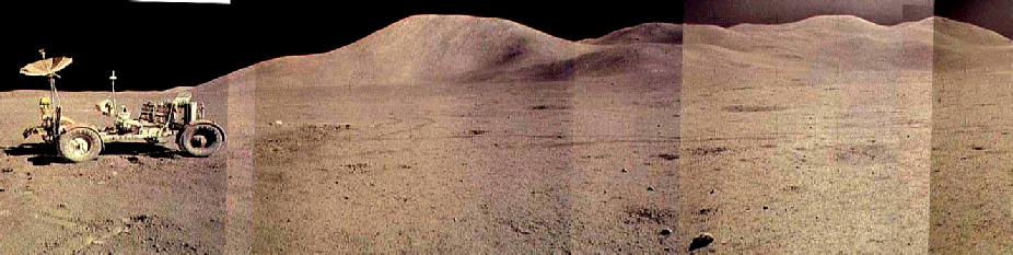
Boven 3D render, onder Apollo 15 geplakte panorama.
En ja als de je lengte van de schaduwen veregelijkt met de lengte en hoogte graad van de Zon op dat tijdstip... klopt het. In de 16mm beelden zie ook dat schaduwen van lengte veranderen, allemaal kloppend met de beweging van de zon.
Verder met wat foto's op een hoek gemaakt, zodat een 3D-render niet nodig is voor een 3D gevoel.
Echte foto's:
Crop van High Definition frame 3 of LO4 image number 78 (beste foto's van maanoppervlakte vòòr Apollo)
Crop van AS15-M-0972, Apollo 15 mapping camera
Crop van AS17-147-22467 Apollo 17, LM benaderd CSM om te koppelen.
LRO, crop van M192793697LR
[ Bericht 3% gewijzigd door t4600c op 15-05-2017 21:12:18 ]
Hoewel ze foto's hadden van het maanoppervlakte, hadden ze geen instrumenten om hoogte te meten. Ze moesten alles inschatten met schaduwen, wat op de maan veraadelijk is door haar reflectieve grond.
De wetenschappelijke data is moelijk om mee te werken, omdat het natuurlijk bedoeld is voor...wetenschappers
Uitendelijk lukten het om 3D renders te maken door foto's en hoogte data te combineren.
Zie hier, renders van raw data direct van de respectieve websites (JAXA, india, LRO etc) (Staat allemaal online, maar is niet te openenen met normale image software omdat het veel meer data dan alleen plaatjes bevat.)
Links 3D render, rechts AS17-147-22467

Boven 3D render, onder Apollo 15 geplakte panorama.
En ja als de je lengte van de schaduwen veregelijkt met de lengte en hoogte graad van de Zon op dat tijdstip... klopt het. In de 16mm beelden zie ook dat schaduwen van lengte veranderen, allemaal kloppend met de beweging van de zon.
Verder met wat foto's op een hoek gemaakt, zodat een 3D-render niet nodig is voor een 3D gevoel.
Echte foto's:
Crop van High Definition frame 3 of LO4 image number 78 (beste foto's van maanoppervlakte vòòr Apollo)

Crop van AS15-M-0972, Apollo 15 mapping camera

Crop van AS17-147-22467 Apollo 17, LM benaderd CSM om te koppelen.

LRO, crop van M192793697LR

[ Bericht 3% gewijzigd door t4600c op 15-05-2017 21:12:18 ]
http://wms.lroc.asu.edu/apollo/browse?camera=P&mission=15
http://wms.lroc.asu.edu/apollo/browse?camera=P&mission=16
http://wms.lroc.asu.edu/apollo/browse?camera=P&mission=17
+36.000 Gigapixel aan fotografische data van het maanoppervlak.
Voortgang van Apollo 15:
CSM Rev. 17
107:40 MET Before EVA-1:
http://wms.lroc.asu.edu/a(...)age_name=AS15-P-9377
http://wms.lroc.asu.edu/a(...)age_name=AS15-P-9370
Apollo 15 crop:
CSM Rev. 27
130:19:25 MET
After EVA-1:
http://wms.lroc.asu.edu/a(...)age_name=AS15-P-9430
Apollo 15 crop:
There are some notable differences between these two images. Firstly, the shadow lengths have changed as the sun has risen in the lunar sky, exposing more of the surrounding craters and shortening the LM shadow. Secondly it is possible to make out the evidence of astronaut activity.
There is clear evidence around the LM of disturbed ground, as well as towards where the ALSEP was set up. The latter involved a considerable amount of activity, which explains why the large area around it is so obvious. The LRV (rover) can be seen on the upper left right above the LM. The rover took a different route to and from station 1 and 2, which is why the path is much less easy to make out.
151:59:14 MET
After EVA-2:
http://wms.lroc.asu.edu/a(...)age_name=AS15-P-9798
Apollo 15 crop:
There are two major areas of difference here. Firstly, now that EVA-2 has followed at least some of the path followed for EVA-1 the ground is more disturbed and there is now a noticeable trail running from just west of the LM south.
The next feature is the area extending from the LM to the ALSEP, which is now much more prominent.
The area around the LM is also now much more disturbed
Here’s a close up of the two of them for comparison:
Post-eva-1:
Post-eva-2:
The LM shadow is shorter, something that Dave Scott draws attention to as they pack up at the end of EVA-2. The LRV isn’t quite as easy to spot as before, but luckily we have two other photographs in the form of AS15-P-9800 and AS15-P-9793 , taken just a few minutes apart from the image used, to help clarify things.
Here they are along with a still from footage of the crew climbing inside the LM at the end of the EVA. The APC crops are rotated 180 degrees so that the roughly match the view in the video still. St George’s crater can just be made out centre right of the still. T
The astronauts are climbing a ladder in shade, but the LRV is in sunlight.
Crop 1:
Crop 2:
TV still:
We have a view that is entirely consistent with the object in question being the LRV, in exactly the place that it should be according to the TV footage.
Rev 50.
175:35 MET
After LM redocking with CSM:
http://wms.lroc.asu.edu/a(...)age_name=AS15-P-9814
Apollo 15 crop:
16mm opnamen still tijdens lancering:
LRO:
The shadow on the LM is considerable shorter this time, partly because it is later in the mission and the sun is even higher, but also because half of the LM is now missing, given that the ascent module has just docked with the orbiting CSM. As with the other two EVAs, we can be sure of the LRV location on this occasion as well.
The reason for this is that at the end of EVA-3 the LRV was driven to a last resting place so that it could observe the ascent module’s launch from a safe distance.
You can see the trail this created as a line heading east from the LM, and the LRV itself can be seen on the right hand edge of the photograph.
Apollo 15’s APC imagery presents us with a chronology of the activity around the landing site, revealing how the lighting conditions and disturbances brought about by human activity changed over the course of the mission.
This chronology is (as with every aspect of Apollo) entirely consistent with the documented facts.
[ Bericht 0% gewijzigd door t4600c op 16-05-2017 22:02:54 ]
http://wms.lroc.asu.edu/apollo/browse?camera=P&mission=16
http://wms.lroc.asu.edu/apollo/browse?camera=P&mission=17
+36.000 Gigapixel aan fotografische data van het maanoppervlak.
Voortgang van Apollo 15:
CSM Rev. 17
107:40 MET Before EVA-1:
http://wms.lroc.asu.edu/a(...)age_name=AS15-P-9377
http://wms.lroc.asu.edu/a(...)age_name=AS15-P-9370
Apollo 15 crop:

CSM Rev. 27
130:19:25 MET
After EVA-1:
http://wms.lroc.asu.edu/a(...)age_name=AS15-P-9430
Apollo 15 crop:

There are some notable differences between these two images. Firstly, the shadow lengths have changed as the sun has risen in the lunar sky, exposing more of the surrounding craters and shortening the LM shadow. Secondly it is possible to make out the evidence of astronaut activity.
There is clear evidence around the LM of disturbed ground, as well as towards where the ALSEP was set up. The latter involved a considerable amount of activity, which explains why the large area around it is so obvious. The LRV (rover) can be seen on the upper left right above the LM. The rover took a different route to and from station 1 and 2, which is why the path is much less easy to make out.
151:59:14 MET
After EVA-2:
http://wms.lroc.asu.edu/a(...)age_name=AS15-P-9798
Apollo 15 crop:

There are two major areas of difference here. Firstly, now that EVA-2 has followed at least some of the path followed for EVA-1 the ground is more disturbed and there is now a noticeable trail running from just west of the LM south.
The next feature is the area extending from the LM to the ALSEP, which is now much more prominent.
The area around the LM is also now much more disturbed
Here’s a close up of the two of them for comparison:
Post-eva-1:
Post-eva-2:

The LM shadow is shorter, something that Dave Scott draws attention to as they pack up at the end of EVA-2. The LRV isn’t quite as easy to spot as before, but luckily we have two other photographs in the form of AS15-P-9800 and AS15-P-9793 , taken just a few minutes apart from the image used, to help clarify things.
Here they are along with a still from footage of the crew climbing inside the LM at the end of the EVA. The APC crops are rotated 180 degrees so that the roughly match the view in the video still. St George’s crater can just be made out centre right of the still. T
The astronauts are climbing a ladder in shade, but the LRV is in sunlight.
Crop 1:

Crop 2:
TV still:

We have a view that is entirely consistent with the object in question being the LRV, in exactly the place that it should be according to the TV footage.
Rev 50.
175:35 MET
After LM redocking with CSM:
http://wms.lroc.asu.edu/a(...)age_name=AS15-P-9814
Apollo 15 crop:

16mm opnamen still tijdens lancering:

LRO:

The shadow on the LM is considerable shorter this time, partly because it is later in the mission and the sun is even higher, but also because half of the LM is now missing, given that the ascent module has just docked with the orbiting CSM. As with the other two EVAs, we can be sure of the LRV location on this occasion as well.
The reason for this is that at the end of EVA-3 the LRV was driven to a last resting place so that it could observe the ascent module’s launch from a safe distance.
You can see the trail this created as a line heading east from the LM, and the LRV itself can be seen on the right hand edge of the photograph.
Apollo 15’s APC imagery presents us with a chronology of the activity around the landing site, revealing how the lighting conditions and disturbances brought about by human activity changed over the course of the mission.
This chronology is (as with every aspect of Apollo) entirely consistent with the documented facts.
[ Bericht 0% gewijzigd door t4600c op 16-05-2017 22:02:54 ]
Jeetje, zijn jullie echt serieus? Lijkt weer 'n soort trendy tiener site te zijn.quote:
https://www.youtube.com/channel/UCw95T_TgbGHhTml4xZ9yIqg/videos
“Guys, I'm not out to take on hoaxers”
Welke 'hoaxers' Amy?
http://www.thefreedictionary.com/hoaxer
hoaxer
noun trickster, joker, prankster, spoofer (informal), humbug, bamboozler (informal), hoodwinker, practical joker Example: She will enjoy permanent fame as a literary hoaxer.
https://en.wikipedia.org/wiki/Amy_Shira_Teitel
'As a Jewish writer, she says she came into a difficult problem writing about her childhood hero Wernher von Braun,'
Ja- dat moet zeker zwaar zijn...als je wat rare verhalen over WWII geloven.
In the new 'reality' we will be living in,nothing will be real and everything will be true-David A.McGowan
Why do some people not credit the origin of the quotes they use under their posts?- Tingo
Why do some people not credit the origin of the quotes they use under their posts?- Tingo
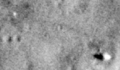
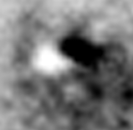
Misschien dat al de Apollo junk in de black hole gezogen is?quote:
Bizar gat in het Maan oppervlak
[ afbeelding ]
Doet mij denken aan een sinkhole op aarde.
Hebben ze al 'n naam voor ?
Amy's Moon Hole misschien?
In the new 'reality' we will be living in,nothing will be real and everything will be true-David A.McGowan
Why do some people not credit the origin of the quotes they use under their posts?- Tingo
Why do some people not credit the origin of the quotes they use under their posts?- Tingo
Och Tingo toch, wat ben je weer prachtig voorspelbaar.quote:
[..]
Jeetje, zijn jullie echt serieus? Lijkt weer 'n soort trendy tiener site te zijn.
https://www.youtube.com/channel/UCw95T_TgbGHhTml4xZ9yIqg/videos
“Guys, I'm not out to take on hoaxers”
Welke 'hoaxers' Amy?
http://www.thefreedictionary.com/hoaxer
hoaxer
noun trickster, joker, prankster, spoofer (informal), humbug, bamboozler (informal), hoodwinker, practical joker Example: She will enjoy permanent fame as a literary hoaxer.
https://en.wikipedia.org/wiki/Amy_Shira_Teitel
'As a Jewish writer, she says she came into a difficult problem writing about her childhood hero Wernher von Braun,'
Ja- dat moet zeker zwaar zijn...als je wat rare verhalen over WWII geloven.
Egregious professor of Cruel and Unusual Geography
Onikaan ni ov dovah
Onikaan ni ov dovah
Over welk jaartal heb je het hier?quote:
Ben al een tijdje ergens mee bezig. Recente satellieten rond de maan zijn bekent door hun bizare foto's maar ze verzamelen veel meer data. Waaronder hoogte van het maanoppervlakte.
Hoewel ze foto's hadden van het maanoppervlakte, hadden ze geen instrumenten om hoogte te meten. Ze moesten alles inschatten met schaduwen, wat op de maan veraadelijk is door haar reflectieve grond.
De wetenschappelijke data is moelijk om mee te werken, omdat het natuurlijk bedoeld is voor...wetenschappers
Uitendelijk lukten het om 3D renders te maken door foto's en hoogte data te combineren.
Zie hier, renders van raw data direct van de respectieve websites (JAXA, india, LRO etc) (Staat allemaal online, maar is niet te openenen met normale image software omdat het veel meer data dan alleen plaatjes bevat.)
Links 3D render, rechts AS17-147-22467
[ afbeelding ]
Boven 3D render, onder Apollo 15 geplakte panorama.
[ afbeelding ]
[ afbeelding ]
En ja als de je lengte van de schaduwen veregelijkt met de lengte en hoogte graad van de Zon op dat tijdstip... klopt het. In de 16mm beelden zie ook dat schaduwen van lengte veranderen, allemaal kloppend met de beweging van de zon.
Verder met wat foto's op een hoek gemaakt, zodat een 3D-render niet nodig is voor een 3D gevoel.
Echte foto's:
Crop van High Definition frame 3 of LO4 image number 78 (beste foto's van maanoppervlakte vòòr Apollo)
[ afbeelding ]
Crop van AS15-M-0972, Apollo 15 mapping camera
[ afbeelding ]
Crop van AS17-147-22467 Apollo 17, LM benaderd CSM om te koppelen.
[ afbeelding ]
LRO, crop van M192793697LR
[ afbeelding ]
1 + 1 = blauw
Jij komt altijd met de domme trendy space reporter/space historian/space babe/NASA-SpaceX whore vids. -edit, niet doen-quote:
[..]
Och Tingo toch, wat ben je weer prachtig voorspelbaar.
[ Bericht 2% gewijzigd door Lavenderr op 17-05-2017 23:12:26 ]
In the new 'reality' we will be living in,nothing will be real and everything will be true-David A.McGowan
Why do some people not credit the origin of the quotes they use under their posts?- Tingo
Why do some people not credit the origin of the quotes they use under their posts?- Tingo