WKN Weer, Klimaat en Natuurrampen
Lees alles over het onstuimige weer op onze planeet, volg orkanen en tornado's, zie hoe vulkanen uitbarsten en hoe Moeder Aarde beeft bij een aardbeving. Alles over de verwoestende kracht van onze planeet en tal van andere natuurverschijnselen.


Foto's van de schade op Saipanquote:Massive damage in saipan from Soudelor
Guam may have been spared over the weekend from Mother Nature's wrath, but our neighbors in the north took a beating from Typhoon Soudelor last night. Jillian Angeline with KSPN2 News in Saipan reports massive destruction in Saipan due to a direct passage of the eyewall over the island.
"Trees are down, over 100 power poles are down now, and there's no timetable for restoration for power, water, or wastewater, the CUC met with a federal dept. of energy representative. He flew in with FEMA who are here to assess damage and the needs. The CNMI Ports Authority has not made a decision on when the airport will reopen. Only after the runway is free and clear of debris will arrangements be made for relief flights. About 400 people have taken shelters all around Saipan. It's a minute-by-minute assessment," Angeline detailed.
CNMI Acting Governor Ralph Torres has declared the commonwealth in a state of major disaster and significant emergency.


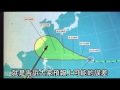
Soudelor zichtbaar vanuit het ISSquote:Typhoon Soudelor to Threaten China, Taiwan
Typhoon Soudelor in the western Pacific Ocean will continue to strengthen over the coming days, eventually threatening Taiwan, eastern China late this week or next weekend.
Soudelor, now located to the west of Guam and the northern Mariana Islands will continue to depart the area after bringing powerful winds and downpours on Sunday night.
The center of the storm passed directly over the island of Saipan, to the north of Guam with Category 2 hurricane-force winds.
Winds to near 170 kph (105 mph) were reported on Saipan as the eyewall of Soudelor passed over the island. Guam to the south was largely spared any damaging winds as gusts reached 50-65 kph (30-40 mph) for several hours.
Soudelor will continue to strengthen while it crosses the northern Philippines Sea on its way towards eastern Asia. Warm ocean water and low wind shear will allow for significant strengthening and the typhoon could reach the equivalent strengthen of a Category 4 or 5 hurricane by the middle of next week.
Despite being a week out, there is growing confidence that Taiwan, eastern China and the southern Ryukyu Islands will have to contend with Soudelor as early as Thursday night or Friday, with continued impacts into next week.
The tropical system is still expected to be a significant typhoon during this time, so residents from Shanghai to Taipei should being making initial preparations for the storm.


Meer weten over alle (actuele) orkanen overal ter wereld?
WKN / Hurricane Season 2015 #1: Orkanen & cyclonen wereldwijd
Ook op deze sites kan je Soudelor prachtig volgen:
http://rammb.cira.colosta(...)60&loop_speed_ms=100
https://www.windyty.com/?2015-08-05-09,24.747,124.541,5
[ Bericht 4% gewijzigd door Frutsel op 05-08-2015 15:43:16 ]

Koers is nu steeds meer naar het noorden bijgesteld, maar is nog ver weg. Kan nog steeds een landfall worden.


De kerndruk is gedaald naar 900mb (wat extreem laag is). De windsnelheid ligt nu rond de 260 km, waarbij de windstoten oplopen tot 315 km.
Soudelor is nu een categorie 5.
Soudelor is nu een categorie 5.


Zal me benieuwen wat de kracht straks bij landfall zal zijn 
quote:A slightly weaker Soudelor threatens Taiwan
Having completed an eyewall regeneration cycle, Super Typhoon Soudelor was sporting a less impressive convective shield and slightly weaker sustained winds on Tuesday, but it remained a formidable storm. Peak sustained winds were estimated by the Joint Typhoon Warning Center (JTWC) at 130 knots (around 150 mph) at 1800 GMT (2:00 pm EDT) Tuesday.
Soudelor remains on a classic west-northwest path around the south side of an upper-level ridge, and models are still in close agreement on a landfall in Taiwan on Friday night or Saturday morning local time. The JTWC is calling for gradual weakening over the next couple of days, mainly due to subsidence related to a nearby tropospheric upper-level trough (TUTT).
Apart from the TUTT, conditions are highly supportive of some eventual restrengthening. Category 4 strength is possible at landfall, according to the JTWC forecast from 2100 GMT Tuesday (5:00 pm EDT). Soudelor could end up even stronger than predicted if another rapid intensification cycle were to take place (such cycles are difficult to predict in advance).
Soudelor will likely go on to strike mainland China as a strong tropical storm or Category 1 typhoon.
De meeste modellen gaan voor minimaal cat 3 of 4 volgens mij. TSR gaat voor een cat 4.quote:Op woensdag 5 augustus 2015 09:17 schreef Frutsel het volgende:
Zal me benieuwen wat de kracht straks bij landfall zal zijn
[..]
JTWC gaat voor 231 km net voor landfall (categorie 4).


twitter:ExtremeStorms twitterde op woensdag 05-08-2015 om 15:53:10 Incredible shot of Typhoon Soudelor aftermath on Saipan via my FB feed: http://t.co/wKw68bfcvr reageer retweet
 Incredible shot of Typhoon Soudelor aftermath on Saipan via my FB feed:
wtf


OMG HOLY CRAP GAAN WE DOOD???!?!?!?!?!?!?
"The only sight worse than a sad dwarf is a very sad dwarf"
"Met dubbel s welteverstaan"
"Met dubbel s welteverstaan"
Sorry?quote:Op donderdag 6 augustus 2015 22:00 schreef Geralt het volgende:
OMG HOLY CRAP GAAN WE DOOD???!?!?!?!?!?!?

Het ziet er allemaal voor mij als totale leek op dit gebied nogal heftig uitquote:
Of is dit gewoon een doodnormale storm zoals we ze wel vaker hebben ergens in de wereld?
"The only sight worse than a sad dwarf is a very sad dwarf"
"Met dubbel s welteverstaan"
"Met dubbel s welteverstaan"
Nou ja doodnormaal is een groot woord, maar dit soort stormen komen in Azie wel vaker voor.quote:Op donderdag 6 augustus 2015 23:34 schreef Geralt het volgende:
[..]
Het ziet er allemaal voor mij als totale leek op dit gebied nogal heftig uit
Of is dit gewoon een doodnormale storm zoals we ze wel vaker hebben ergens in de wereld?

http://www.wunderground.c(...)t.html?entrynum=3064quote:A bigger question mark is how strong Soudelor will be when it reaches Taiwan.
Soudelor currently has a rather large eye (roughly 55 miles across, close to half a degree of longitude), with an intensifying solid ring of convection surrounded by a large field of spiral banding. Mesovortices (small-scale circulations) could be seen spinning within the large eye in visible satellite imagery. Soudelor’s brief stint as a super typhoon earlier this week was interrupted by an eyewall replacement cycle, with the much larger eye succeeding the typhoon’s originally tiny eye (about 5 miles in diameter, one of the smallest on record for a landfalling system, when Soudelor struck Saipan). Since that point, Soudelor has had some trouble rebuilding a large, solid core of convection, despite its excellent overall structure and the gradually increasing size of its envelope of moisture and banding. Dvorak imagery from the MTSAT satellite over the last few hours shows that very cold cloud tops (a sign of intense convection) are beginning to wrap around Soudelor’s eye once again, and temperatures within the eye are warming, another sign of intensification. Soudelor is now moving over slightly warmer SSTs (29-30°C, or 84-86°F, about 1°C above average) as it approaches Taiwan, and wind shear will be low (only around 5 - 10 mph).
Dynamical models generally agree in bringing Soudelor back to at least Category 3 strength before landfall in Taiwan, and I would not be at all surprised to see Soudelor pass the Category 4 threshold. The nation’s urbanized areas are well prepared for high typhoon winds, though widespread power outages and transportation disruptions are likely. Massive amounts of rain will fall where Soudelor slams into the north-south mountain range that spans most of Taiwan, and substantial local flooding and mudslides can be expected. Fortunately, Soudelor’s steady movement will help keep its rainfall totals below the truly prodigious amounts that slower-moving systems such as 2009’s Typhoon Morakot can produce. Morakot was only a Category 1 storm, but it moved in a leisurely cyclonic loop across northern Taiwan, prolonging the widespread intense rainfall. Morakot caused more than 450 deaths and some $3.3 billion US in damage.
Twee slachtoffers... Meisje van hierboven was van een tweeling en hun moeder ook overleden. Het andere meisje hield zich vast aan het lichaam van dr moeder en heeft het vooralsnog overleefd
Tragisch..
http://focustaiwan.tw/news/asoc/201508070016.aspx
Tragisch..
http://focustaiwan.tw/news/asoc/201508070016.aspx


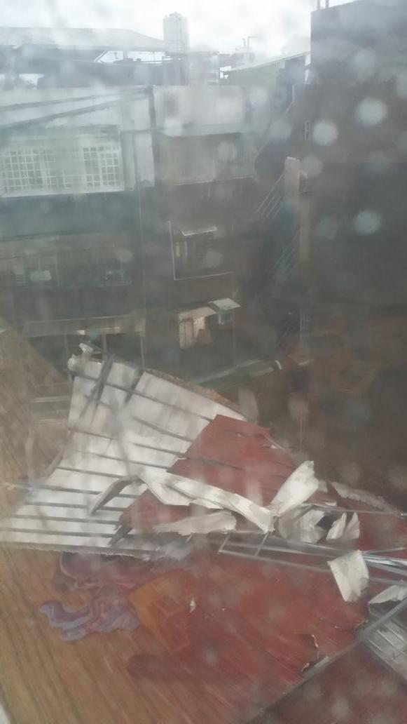
twitter:JohnAEastwood twitterde op zaterdag 08-08-2015 om 02:40:32 #TyphoonSoudelor wrecked the roof of the bldg next door. See the intact tin roof at the top of the pic. Not for long http://t.co/vIxv9OGsv0 reageer retweet


Tyfoon Soudelor maakt ook in China slachtoffers
Tyfoon Soudelor, die eerder op Taiwan levens eiste, heeft het Chinese vasteland bereikt. Ook daar zijn de eerste doden gevallen.
Volgens Chinese media kwam de tropische storm zaterdagavond (lokale tijd) aan land in de oostelijke kustprovincie Fujian. Meer dan 160.000 mensen waren toen al geeëvacueerd.
In Fuzhou, de provinciehoofdstad, is een groot deel van het centrum onder water komen te staan. Meer dan 10.000 bomen zijn omgevallen en het verkeer is tot stilstand gekomen door de stortbuien.
Taiwan
Vervolgens draaide Soudelor over de omliggende provincies Zhejiang en Jiangxi. In de havenstad Wenzhou zijn negen mensen omgekomen en worden nog drie anderen vermist, meldt staatspersbureau Xinhua zondag.
De slachtoffers en vermiste mensen zijn volgens de plaatselijke autoriteiten vermoedelijk door de overstromingen verzwolgen of onder ingestorte huizen terechtgekomen. Er viel in 24 uur tijd 645 mm regen, hetgeen volgens de autoriteiten de hevigste regenval in honderd jaar betekende.
Vliegvelden
Verspreid over de getroffen provincies zijn vliegvelden en snelwegen gesloten. In de provincie Fujian werden meer dan 530 vluchten geannuleerd en kwamen meer dan twee miljoen huishoudens zonder stroom te zitten, aldus Xinhua.
Op Taiwan vielen eerder dit weekend zeker zes doden door Soudelor. Vier mensen worden nog vermist en ruim honderd anderen raakten gewond.
http://www.nu.nl/buitenla(...)na-slachtoffers.html

Apart, die witte auto werd meegesleurd door de tornado terwijl de auto waar de filmer in zat stevig op de grond bleef. Of was het zo'n tornadojagerding?quote:
Tornados kunnen zeer lokaal zijn en dat is juist ook hier duidelijk zichtbaar.quote:Op maandag 10 augustus 2015 10:06 schreef Knitted het volgende:
[..]
Apart, die witte auto werd meegesleurd door de tornado terwijl de auto waar de filmer in zat stevig op de grond bleef. Of was het zo'n tornadojagerding?
Het leek wel alsof de filmer er een paar sec in zat.quote:
[..]
Tornados kunnen zeer lokaal zijn en dat is juist ook hier duidelijk zichtbaar.

quote:Tyfoon Soudelor maakt negen slachtoffers in China
In het oosten van China heeft de tyfoon Soudelor negen doden gemaakt. De streek kampt met de zwaarste regenbuien sinds een eeuw. Dat meldt het officiële persbureau Xinhua vandaag. In Taiwan maakte de tyfoon ook al zes doden. In China zijn nog eens drie andere mensen vermist.
Volgens Chinese media kwam de tropische storm gisterenavond (lokale tijd) aan land in de oostelijke kustprovincie Fujian. Meer dan 160.000 mensen waren toen al geeëvacueerd. In Fuzhou, de provinciehoofdstad, is een groot deel van het centrum onder water komen te staan. Meer dan 10.000 bomen zijn omgevallen en het verkeer is tot stilstand gekomen door de stortbuien.
Vervolgens draaide Soudelor over de omliggende provincies Zhejiang en Jiangxi. In de havenstad Wenzhou zijn negen mensen omgekomen en worden nog drie anderen vermist, meldde staatspersbureau Xinhua vandaag. De slachtoffers en vermiste mensen zijn volgens de plaatselijke autoriteiten vermoedelijk door de overstromingen verzwolgen of onder ingestorte huizen terechtgekomen. Er viel in 24 uur tijd 645 mm regen, hetgeen volgens de autoriteiten de hevigste regenval in honderd jaar betekende.
Verspreid over de getroffen provincies zijn vliegvelden en snelwegen gesloten. In de provincie Fujian werden meer dan 530 vluchten geannuleerd en kwamen meer dan twee miljoen huishoudens zonder stroom te zitten, aldus Xinhua.
Op Taiwan vielen eerder dit weekend zeker zes doden door Soudelor. Vier mensen worden nog vermist en ruim honderd anderen raakten gewond.
Volgens het Nationaal Meteorologisch Centrum zal Soudelor tegen de avond afzwakken tot een tropische storm.
|
|