WKN Weer, Klimaat en Natuurrampen
Lees alles over het onstuimige weer op onze planeet, volg orkanen en tornado's, zie hoe vulkanen uitbarsten en hoe Moeder Aarde beeft bij een aardbeving. Alles over de verwoestende kracht van onze planeet en tal van andere natuurverschijnselen.


Wipha gevaar voor Fukushima?
Wipha is nu een categorie 4 tyfoon met een windsnelheid van 209 km/u, waarbij de windstoten kunnen oplopen tot bijna 260 km/u. De kerndruk is 940mb.
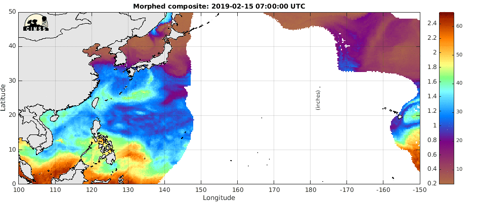
De tyfoon trekt naar het noorden richting Japan, waarbij het in kracht zal afnemen, maar zeker een gevaar blijft. De modellen geven nu aan, dat het systeem Japan aan de zuidkant passeert. Het zwaarste windveld zal dan het eiland missen, maar de verwachte neerslag kan een groot probleem worden voor Fukushima.
Zie ook:
WKN / [ACTUEEL] Hurricane Season 2013 #2 Orkanen en Cyclonen
BNW / Fukushima deel 4

Wipha is nu een categorie 4 tyfoon met een windsnelheid van 209 km/u, waarbij de windstoten kunnen oplopen tot bijna 260 km/u. De kerndruk is 940mb.
De tyfoon trekt naar het noorden richting Japan, waarbij het in kracht zal afnemen, maar zeker een gevaar blijft. De modellen geven nu aan, dat het systeem Japan aan de zuidkant passeert. Het zwaarste windveld zal dan het eiland missen, maar de verwachte neerslag kan een groot probleem worden voor Fukushima.

quote:Typhoon Wipha a threat to Japan
Huge and powerful Category 4 Typhoon Wipha continues intensifying as it heads northwest towards Japan. The storm is expected to peak at 145 mph winds on Monday near 12 UTC. By Tuesday, Wipha will recurve to the northeast and begin weakening, passing just offshore from Tokyo, Japan, sometime between 00 - 06 UTC on Wednesday. Wipha will be rapidly weakening as it makes its closest approach to Tokyo, due to high wind shear and cooler waters, and the coast of Japan should experience winds below hurricane force if the core of Wipha passes offshore as expected. High winds and heavy rains from Wipha may be a concern for the Fukushima nuclear site, where rainfall from Typhoon Man-Yi on September 16 complicated clean-up efforts of the reactors damaged by the March 2011 earthquake and tsunami.
JeffMasters
Zie ook:
WKN / [ACTUEEL] Hurricane Season 2013 #2 Orkanen en Cyclonen
BNW / Fukushima deel 4
Gaan we nu allemaal dood? 
Stop the violence
Down with the hate
Op vrijdag 21 augustus 2015 01:36 schreef engeopa het volgende:
Deadprez is een frequent bezoeker van Joop.nl. Kneusje eerste klas. walgelijke policor hoofd in de wolken multicultilover.
Down with the hate
Op vrijdag 21 augustus 2015 01:36 schreef engeopa het volgende:
Deadprez is een frequent bezoeker van Joop.nl. Kneusje eerste klas. walgelijke policor hoofd in de wolken multicultilover.

Niet echt de beste plek om een kerncentrale te bouwen...quote:Op zondag 13 oktober 2013 23:17 schreef roislecxe het volgende:
Het zit daar ook niet bepaald mee he.
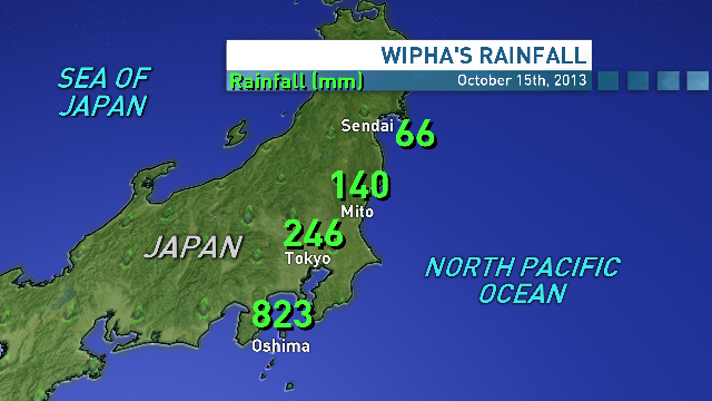
Op een enkele plek al bijna 70mm neerslag. Wind gaat nog verder toenemen en zit nu tussen 7 - 9 Beaufort.

Eric Holthaus @EricHolthaus
Typhoon #Wipha's strongest wind and rain in Fukushima, Japan will be over next 3-4 hours.
Typhoon #Wipha's strongest wind and rain in Fukushima, Japan will be over next 3-4 hours.
Veel doden door modderlawines in Japan.


quote:TOKYO -- A typhoon caused deadly mudslides that buried people and destroyed homes on a Japanese island Wednesday before sweeping up the Pacific coast, grounding hundreds of flights and disrupting Tokyo's transportation during the morning rush. At least 17 deaths were reported and nearly 50 people were missing.
Hardest hit from Typhoon Wipha was Izu Oshima island, which is about 75 miles south of Tokyo. Rescuers found 16 bodies, most of them buried by mudslides, police and town officials said. Dozens of homes were destroyed, and about 45 people were missing.
Orkaan Japan:doden en vermisten
Een orkaan die vanochtend aan land kwam op het Japanse eiland Izu Oshima heeft aan zeker 17 mensen het leven gekost. De orkaan bracht overstromingen en modderstromen op gang, waardoor huizen werden verwoest. Tegen de vijftig mensen worden vermist.
In de ochtend bleven vliegtuigen in Tokio vanwege het noodweer aan de grond en het openbaar vervoer was verstoord. De orkaan ging gepaard met windstoten van 120 kilometer per uur. Later op de dag nam de orkaan in kracht af tot een tropische storm.
Meer dan 350 huizen op Izu Oshima zijn zwaar beschadigd of verwoest.
http://nos.nl/tekst/563211-orkaan-japandoden-en-vermisten.html


|
|