WKN Weer, Klimaat en Natuurrampen
Lees alles over het onstuimige weer op onze planeet, volg orkanen en tornado's, zie hoe vulkanen uitbarsten en hoe Moeder Aarde beeft bij een aardbeving. Alles over de verwoestende kracht van onze planeet en tal van andere natuurverschijnselen.


Phailin kan zeer gevaarlijke orkaan worden
India maakt zich op voor de naderende tropische storm Phailin. De storm, die op dit moment windstoten tot 185 km/u haalt, zal naar verwachting in de nacht van 12 oktober India treffen. De modellen zijn het er nog niet over eens hoe krachtig de orkaan zal worden. De voorspellingen lopen uiteen van een categorie 1 orkaan tot zelfs een categorie 3 orkaan.
De landfall zal vermoedelijk zijn in de regionen Andhra Pradesh en Odisha. Dat gebied is dichtbevolkt en heeft een zeer ongunstige ligging qua stormsurge. Het blijft even afwachten hoe krachtig Phailin daadwerkelijk nog zal worden. In 1999 vielen er in hetzelfde gebied ruim 10.000 doden bij een categorie 5 orkaan.
quote:Dangerous Tropical Cyclone Phailin Headed Towards India
In the North Indian Ocean's Bay of Bengal, Tropical Storm Phailin has formed off the west coast of Thailand, and is moving west-northwest towards India at 8 mph. Satellite images show that Phailin is a medium-sized storm that is increasing in organization and intensity. Water temperatures are warm, 28 - 29°C, and the ocean heat content is very high, 80 - 100 kJ/cm^2--a level often associated with rapid intensification. With wind shear low, Phailin should be able to intensify into at least a Category 1 storm before landfall occurs near 12 UTC on Saturday, as predicted by the Joint Typhoon Warning Center. The India Meteorological Department (IMD) is predicting that Phailin may be able to intensify into a Category 3 storm before landfall. The 12Z Wednesday run of the HWRF model predicted that Phailin would peak as a Category 3 storm with 125 mph winds at landfall on Saturday. The northeast coast of India where Phailin is expected to hit is vulnerable to high storm surges and is densely populated, so Phailin has the potential to be a very dangerous storm.
India's tropical cyclone history
Only two Bay of Bengal tropical cyclones have hit India at hurricane strength since 2000. The most recent was Cyclone Thane, which hit Southeast India on December 30, 2011, as a Category 1 storm with 75 mph winds. Thane killed 48 people and did $250 million in damage. The most recent major tropical cyclone to hit India was the 1999 Odisha Cyclone, which hit Northeast India in the Indian state of Odisha (formerly called Orissa) near the city of Bhubaneswar as a Category 4 storm with 155 mph winds on October 29, 1999. The mighty storm, which had been at Category 5 strength with 160 mph winds and a 912 mb central pressure shortly before landfall, drove a storm surge of 26 feet (8 meters) onto the coast. The storm stalled just inland, dumping torrential rains on portions of India already saturated from the landfall of Category 4 Tropical Cyclone 04B just twelve days before. The catastrophe killed 9,658 people and left $2.5 billion in damage (1999 dollars), India's most expensive and fourth deadliest tropical cyclone in the past 100 years. Six other Indian tropical cyclones occurring before 1900 were deadlier; see wunderground's list of the 35 Deadliest Tropical Cyclones in World History. During the past two centuries, 42 percent of Earth's tropical cyclone-associated deaths have occurred in Bangladesh, and 27 percent have occurred in India (Nicholls et al., 1995.)

Meer weten over orkanen en waar ze zich nu bevinden?
WKN / [ACTUEEL] Hurricane Season 2013 #2 Orkanen en Cyclonen
[ Bericht 2% gewijzigd door Frutsel op 11-10-2013 22:56:03 ]


35 miljoen mensen in de provincie waar de landfall zal zijn.quote:Op donderdag 10 oktober 2013 18:07 schreef Frutsel het volgende:
tering dat is hard gegaan
dat kan nog een beste ramp worden


Zal me niets verbazen. Oog is klein, dat betekent een snelle kracht toename.quote:
vermoedelijk nu een cat.5, lees ik op storm2k.org
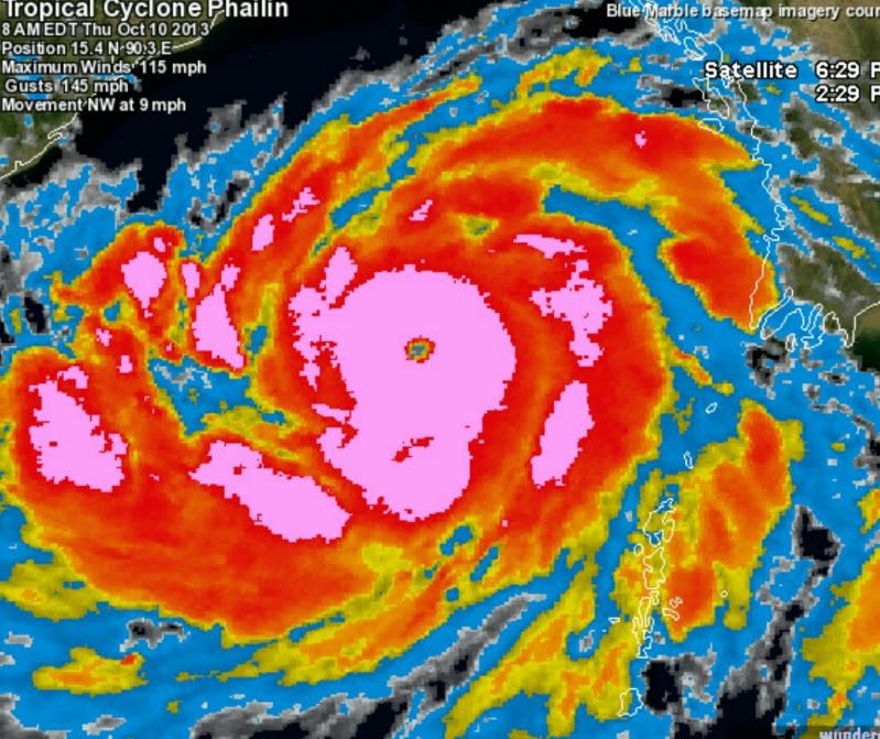


JeffMastersquote:Very dangerous Tropical Cyclone Phailin, in the North Indian Ocean's Bay of Bengal, has put on an impressive burst of rapid intensification, going from a tropical storm with 65 mph winds to a formidable Category 3 storm with 115 mph winds in just twelve hours. Satellite estimates of Phailin's strength at 8 am EDT ranged as high as 135 mph. Satellite images show that Phailin, whose name means "a sapphire" in Thai, continues to intensify. The cloud tops of the very intense thunderstorms in the eyewall are expanding and cooling, showing that their updrafts are growing stronger and pushing the clouds higher into the atmosphere. Water temperatures are warm, 28 - 29°C, and the ocean heat content is very high, 80 - 100 kJ/cm^2--a level often associated with rapid intensification. With wind shear low, Phailin should be able to continue to intensify until an eyewall replacement cycle begins. It is very difficult for a tropical cyclone to maintain an eye diameter less than ten miles across before the inner core grows unstable and the eyewall collapses, with a new, larger-diameter eyewall forming from an outer spiral band. This process typically weakens the top winds of a tropical cyclone by 5 - 15 mph, but spreads hurricane-force winds over a larger area of ocean, resulting a larger storm surge, but less wind damage. With Phailin's eye diameter already down to a tiny 9 miles, an eyewall replacement cycle is likely to occur by Friday morning.
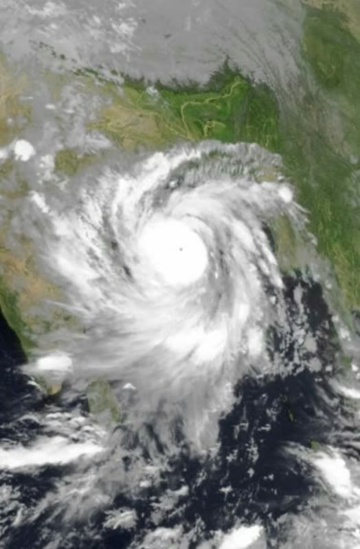
De tyfoon is nu een categorie 5 en zoals het nu staat blijft dat zo tot de landfall. Windveld is nu 250 km/u met windstoten boven de 300 km/u.


quote:Tienduizenden vluchten voor immense cycloon India
Inwoners van de oostkust van India zetten zich schrap voor een cycloon die zo groot is als de helft van het land en die zaterdagavond aan land komt. Tienduizenden mensen zijn de laaggelegen gebieden ontvlucht nadat de overheden hadden gewaarschuwd voor grote schade door de cycloon Phailin.
Phailin ligt nu nog 600 kilometer voor de kust in de Baai van Bengalen en zou volgens deskundigen net zo groot en krachtig zijn als de orkaan Katrina, die in 2005 aan de Amerikaanse Golfkust en in New Orleans een verwoesting aanrichtte. Het Indiase Meteorologische Departement omschreef Phailin als een 'zeer zware cyclonische storm' met windsnelheden van 210 tot 220 kilometer per uur en windstoten tot 305 kilometer per uur.
Schuilkelders
Zaterdagochtend moeten 100.000 mensen een veilig heenkomen hebben gevonden. Nu al zitten 5000 families in schuilkelders en schoolgebouwen, waar extra proviand is opgeslagen. De golven worden inmiddels opgezweept tot 3,5 meter hoogte, hoewel het de regering moeite kost de vissers ervan te overtuigen dat ze hun boten moeten verlaten.
India gaat ervan uit dat de cycloon grote schade aanricht aan de oogst, dorpen en oude gebouwen. Ook de elektriciteits- en watervoorzieningen zouden in gevaar komen door Phailin, evenals de spoorwegverbindingen.
Wat een enorme cycloon. Die gaat vast veel schade aanrichten; hopelijk kost hij geen mensenlevens.quote:
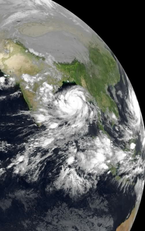
[ afbeelding ]
Mooi zichtbaar vanuit de ruimte
Ik zit zelf momenteel in Chennai. Hier worden geen maatregelen genomen, dat ik weet. Zal hier wel een flinke storm zijn morgenochtend, maar meer niet denk ik.
http://www.wunderground.c(...)t.html?entrynum=2550quote:Phailin is likely to be the strongest tropical cyclone to affect India in fourteen years, since the great 1999 Odisha Cyclone. That terrible storm hit Northeast India in the Indian state of Odisha (formerly called Orissa) near the city of Bhubaneswar, as a Category 4 storm with 155 mph winds on October 29, 1999. The mighty cyclone, which peaked at Category 5 strength with 160 mph winds and a 912 mb central pressure shortly before landfall, drove a storm surge of at least 19' (5.9 meters) onto the coast (Kalsi et al., 2004.) The storm stalled just inland, dumping torrential rains on portions of India already saturated from the landfall of Category 4 Tropical Cyclone 04B just twelve days before. The catastrophe killed 9,658 people and left $2.5 billion in damage (1999 dollars), India's most expensive and fourth deadliest tropical cyclone in the past 100 years.
And what rough beast, its hour come round at last,
Slouches towards Bethlehem to be born?
Slouches towards Bethlehem to be born?
Cyclone Phailin 'may be worse than Katrina'

quote:Cyclone Phailin is forecast to hit the coast between Kalingapatnam in Andhra Pradesh and Paradip in Odisha late on Saturday with a maximum wind speed of 220kmph (135mph), the India Meteorological Department (IMD) said in its latest bulletin.
However, both London-based Tropical Storm and the US navy's Joint Typhoon Warning Centre forecast winds reaching 315kmph (195mph) on landfall, classifying Phailin as a Category 5 storm — the most powerful .
"Phailin is already worse than what the IMD is forecasting. A recent satellite estimate put Phailin's current intensity on par with 2005's Hurricane Katrina in the United States," said Eric Holthaus, meteorologist for Quartz, a US-based online magazine which covers global economy-related issues.
http://timesofindia.india(...)cleshow/23983892.cms
 Op
Op
Het is Phailin.quote:
[..]
Als ik het google, vind ik maar 3x Phalin en de rest is Phailin.
Heftige storm, hopelijk zal de schade meevallen.

You don't need a weatherman to know which way the wind blows.
---------------------------------------------------------------------------------------------------------------------------------------------
Album top 100 2024
---------------------------------------------------------------------------------------------------------------------------------------------
Album top 100 2024
|
|