WKN Weer, Klimaat en Natuurrampen
Lees alles over het onstuimige weer op onze planeet, volg orkanen en tornado's, zie hoe vulkanen uitbarsten en hoe Moeder Aarde beeft bij een aardbeving. Alles over de verwoestende kracht van onze planeet en tal van andere natuurverschijnselen.


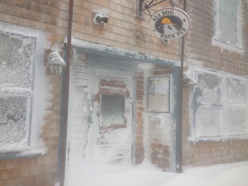
Nou, kon ik weer fatsoenlijk naar werk rijden (al liggen er nog wel overal bergen ijs), en kon ik net een weekje of zo het gras weer zien, krijgen we weer sneeuw. Ben het nu wel zat.
"Bleach is healthy. It's mostly water. And we are mostly water. Therefore, we are bleach."

30 cm is mogelijk.quote:Op zaterdag 1 maart 2014 15:18 schreef OMG het volgende:
Nou, kon ik weer fatsoenlijk naar werk rijden (al liggen er nog wel overal bergen ijs), en kon ik net een weekje of zo het gras weer zien, krijgen we weer sneeuw. Ben het nu wel zat.
Gras is ver te zoeken hier. Nu komt het volgende probleem: Overstromingen als het straks (ooit?quote:
Nou, kon ik weer fatsoenlijk naar werk rijden (al liggen er nog wel overal bergen ijs), en kon ik net een weekje of zo het gras weer zien, krijgen we weer sneeuw. Ben het nu wel zat.
'We' staan nummer drie.
Current Top 25 Snowiest US Cities
Patience is not one of my virtues, neither is memory. Or patience for that matter.
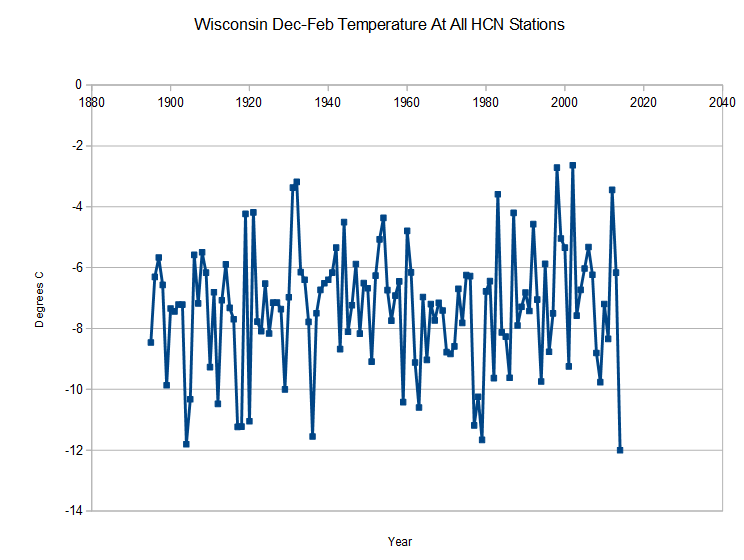
Winter of 2013 - 2014: Top-10 Coldest in Midwest; Warmest on Record in California
The winter of 2013 - 2014 will go down in the history books in the Midwest U.S. as a top-ten coldest winter on record, but ranked as the warmest winter on record in California. Temperatures averaged over December 2013 - February 2014 in the contiguous U.S. made it our 34th coolest winter since records began in 1895, said NOAA's National Climatic Data Center (NCDC) in their latest State of the Climate report. The last winter that was colder was 2009 - 2010, which ranked 15th coolest. For comparison, the winter of 2012 - 2013 was the 20th warmest, and the "non-winter" of 2011 - 2012 was the 4th warmest. Seven states had a top-ten coldest winter on record in 2013 - 2014: Wisconsin, Minnesota, Iowa, Missouri, Illinois, Indiana, and Michigan. Three states had a top-ten warmest winter on record: California, Arizona, and Alaska. The Southwest had an unusually dry winter, with California, Arizona, New Mexico, and Texas all recording top-ten dryness. For the nation as a whole, it was the 9th driest winter on record. The winter average snow cover extent for the contiguous U.S. was the 10th largest since record keeping began in 1966.
http://www.wunderground.c(...)t.html?entrynum=2646


quote:Meteorological Bomb Brewing for Canada on Wednesday
The most powerful Nor'easter of the year will gather strength over the waters offshore of Virginia on Tuesday, then head northeast and bring damaging winds, heavy rain and snow, and a substantial storm surge to Nova Scotia and Newfoundland Canada on Wednesday. The storm will brush Cape Cod, Nantucket, and Martha's Vineyard, Massachusetts on Tuesday night and Wednesday morning, bringing at least six inches of snow and wind gusts of up to 60 mph. A Blizzard Watch and Coastal Flood Watch are posted for Cape Cod and Nantucket Island, where a NOAA storm surge model run using the winds from the 00Z run of the GFS model predicted almost a 2 foot surge could occur on Wednesday morning. A surge of this magnitude is capable of causing minor to moderate flooding.
A Meteorological Bomb
As the storm pulls away from the Mid-Atlantic coast on Tuesday evening, it will undergo explosive deepening, meeting the criteria of a "meteorological bomb"--a storm that deepens by at least 24 mb in 24 hours. In fact, the Monday morning 00Z run of the European model shows the pressure falling by more than double that pace--deepening by an extraordinary 40 mb in just eighteen hours, ending at 2 pm EDT Wednesday. When the Nor'easter hits Nova Scotia and Newfoundland on Wednesday evening, the central pressure of the storm is expected to be between 956 - 960 mb, similar to the central pressure of a strong Category 2 hurricane. However, Nor'easters do not form eyewalls with intense winds concentrated over a small area, and this Nor'easter's strong winds will be spread out over a large area. I doubt we'll see sustained hurricane-force winds of 74 mph or greater at any land stations, but sustained winds of 60 - 70 mph are likely in some locations, which will be capable of causing widespread power outages and considerable tree damage. A storm surge of 2 - 4 feet may also cause coastal damage and moderate flooding, if the surge arrives at high tide.
Bron
Interessant systeem. Lijkt te ontstaan boven Florida en trekt dan vrij snel langs de oostkust richting Canada. Kan voor een flinke sneeuwdump gaan zorgen.quote:

Mooi beeld van Noord Amerika. Ook goed te zien waar de sneeuw ligt en ook een aantal van de great Lakes zijn dichtgevroren.

Even though spring began last week, the risk for blizzards will continue. Such a storm is forecast to threaten part of the Atlantic Seaboard at midweek.
The blizzard is expected to swipe eastern New England and slam Atlantic Canada Tuesday night through Wednesday night.
The rest of the East Coast will escape the worst of the storm, but there is still nuisance to disruptive snowfall in store for the spine of the Appalachians, Virginia and the rest of the Northeast.
The blizzard could slow travel, close schools and cause significant disruptions to daily routines.
http://www.accuweather.co(...)tlantic-c-1/24773544
The blizzard is expected to swipe eastern New England and slam Atlantic Canada Tuesday night through Wednesday night.
The rest of the East Coast will escape the worst of the storm, but there is still nuisance to disruptive snowfall in store for the spine of the Appalachians, Virginia and the rest of the Northeast.
The blizzard could slow travel, close schools and cause significant disruptions to daily routines.


http://www.accuweather.co(...)tlantic-c-1/24773544
West-Europa heeft behoorlijk slecht weer gehad dit jaar. Overstromingen, storm etc....quote:Op donderdag 27 maart 2014 09:48 schreef Lemans24 het volgende:
West-Europa heeft z'n slechte weer geruild met de oostkust van de VS, dit jaar.
Nou, nu je het zegtquote:
[..]
West-Europa heeft behoorlijk slecht weer gehad dit jaar. Overstromingen, storm etc....


The strongest Nor'easter of 2014 blasted Prince Edward Island, New Brunswick and Nova Scotia on Wednesday with wind gusts over 100 mph and up to a half meter (19.5") of snow, bringing travel to a standstill and causing power outages that affected about 17,000 customers in Nova Scotia. The mighty storm intensified rapidly on Wednesday afternoon, "bombing" to a central pressure by 2pm EDT of 955 mb--similar to the central pressure of a Category 3 hurricane. The storm's pressure fall of 45 mb in 24 hours is among the greatest on record for a Nor'easter (for comparison, the 1978 Cleveland Superbomb had a pressure drop of 43 millibars in 24 hours, also to 955 mb.) The La Have Bank buoy south of Halifax, Nova Scotia measured a pressure of 957 mb as the center of the storm passed nearby, along with significant wave heights of 29 feet. A wind gust of 129 mph was measured on Wednesday at the Bay of Fundy, and sustained winds of 89 mph with a gust to 115 mph was recorded between 6:30 - 7:30 pm EDT in Wreckhouse, Newfoundland, beating the previous strongest gust of 112 mph set in 2007 (Wreckhouse is named for the terrain-enhanced winds that often cause destruction.) Grand Étangon the Gulf of St Lawrence side of Cape Breton in Nova Scotia recorded top sustained winds of 70 mph, gusting to 102 mph. This location is susceptible to strong "Les Suêtes" winds in this type of setup--"Suêtes" is a dialectal corruption of French "sud-est," or "southeast". These southeasterly winds travel up over Cape Breton and a funneling effect intensifies them as they blow downslope toward the Gulf of St Lawrence. As a result, these gusts are not truly representative of the storm, but rather the storm plus local terrain effects. Environment Canada has a special "Les Suêtes Wind Warning", and issued it for Wednesday's storm.
http://www.wunderground.c(...)t.html?entrynum=2653
http://www.wunderground.c(...)t.html?entrynum=2653
Record Great Lakes Ice Coverage Will Control Spring Weather
Although spring may be in full swing, more than one-third of the Great Lakes remains covered in ice.
The harsh cold from this past winter resulted in extensive ice coverage over the Great Lakes, making it the second highest ice cover on record for the lakes.
Since its peak coverage of 92.19 percent on March 6, 2014, the ice has been melting slowly but still remains to some extent on each of the five lakes.
"Great Lakes ice coverage is shrinking but is still incredibly high for this time of year" said AccuWeather.com Senior Meteorologist Brett Anderson.
As of April 16, 38 percent of the Great Lakes were covered in ice.
"Normally, only about 3 percent of the Great Lakes are still covered with ice at this time of year." said Anderson.
"Even though the ice cover on the Great Lakes has steadily declined over the past month, the area of ice that remains is the highest in over 30 years and more than two times higher than the second highest extent for the same week back in 1996." he said.
Looking back at 2010 and 2012, the ice on the lakes had completely melted by the second week of April.
This image, acquired by the Moderate Resolution Imaging Spectroradiometer (MODIS) on NASA's Aqua satellite, shows the Great Lakes on Feb. 19, 2014, when ice covered 80.3 percent of the lakes.
In addition to causing lower temperatures to linger around the lakes well into spring, the ice has had a negative impact on a variety of businesses that are dependent on the lakes to transport materials.
According to the Associated Press, the ice has caused major problems for the steel industry and has forced the temporary closure of the largest steel mill in the United States.
Steel mills are just one of the many businesses that rely on ships to transport goods and materials by traveling on the open waters of the Great Lakes.
Even though the lakes have significantly less ice than when coverage peaked in early March, some ships still rely on icebreakers to cut paths through the ice for ships to travel.
With warmer days on the way, the ice will continue to melt but will still leave behind below-normal water temperatures.
These chilly waters will continue to influence areas near and downwind of the Great Lakes, as well as folks looking to take to the water for fishing, boating and other recreational activities.
The colder water may also influence different types of weather that typically occur around the lakes.
"The presence of chilly water could reduce the threat of severe weather by keeping the atmosphere more stable." Anderson said. "Fog could be more widespread than usual early in the summer as well."
http://www.accuweather.co(...)ice-coverag/25816804

Although spring may be in full swing, more than one-third of the Great Lakes remains covered in ice.
The harsh cold from this past winter resulted in extensive ice coverage over the Great Lakes, making it the second highest ice cover on record for the lakes.
Since its peak coverage of 92.19 percent on March 6, 2014, the ice has been melting slowly but still remains to some extent on each of the five lakes.
"Great Lakes ice coverage is shrinking but is still incredibly high for this time of year" said AccuWeather.com Senior Meteorologist Brett Anderson.
As of April 16, 38 percent of the Great Lakes were covered in ice.
"Normally, only about 3 percent of the Great Lakes are still covered with ice at this time of year." said Anderson.
"Even though the ice cover on the Great Lakes has steadily declined over the past month, the area of ice that remains is the highest in over 30 years and more than two times higher than the second highest extent for the same week back in 1996." he said.
Looking back at 2010 and 2012, the ice on the lakes had completely melted by the second week of April.
This image, acquired by the Moderate Resolution Imaging Spectroradiometer (MODIS) on NASA's Aqua satellite, shows the Great Lakes on Feb. 19, 2014, when ice covered 80.3 percent of the lakes.
In addition to causing lower temperatures to linger around the lakes well into spring, the ice has had a negative impact on a variety of businesses that are dependent on the lakes to transport materials.
According to the Associated Press, the ice has caused major problems for the steel industry and has forced the temporary closure of the largest steel mill in the United States.
Steel mills are just one of the many businesses that rely on ships to transport goods and materials by traveling on the open waters of the Great Lakes.
Even though the lakes have significantly less ice than when coverage peaked in early March, some ships still rely on icebreakers to cut paths through the ice for ships to travel.

With warmer days on the way, the ice will continue to melt but will still leave behind below-normal water temperatures.
These chilly waters will continue to influence areas near and downwind of the Great Lakes, as well as folks looking to take to the water for fishing, boating and other recreational activities.
The colder water may also influence different types of weather that typically occur around the lakes.
"The presence of chilly water could reduce the threat of severe weather by keeping the atmosphere more stable." Anderson said. "Fog could be more widespread than usual early in the summer as well."
http://www.accuweather.co(...)ice-coverag/25816804

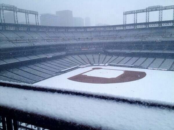
quote:Spring snows hit Rockies; Plains face high winds
DENVER (AP) — Dozens of snowplows were taking to the streets of Denver early Monday, after a powerful spring storm dropped heavy snow across parts of Colorado and Wyoming, even as stormy weather moved into the plains states and drew warnings about conditions ripe for severe thunderstorm and tornadoes.
The Mother's Day storm dropped more than a foot of sloppy, wet snow on parts of the two states. The National Weather Service issued a winter storm warning for most of northern Colorado and parts of southern Wyoming for all of Sunday and for Monday morning.
Forecasters warned that instability ahead of the cold front created conditions for damaging winds as thunderstorms and tornadoes developed in Nebraska Sunday and threatened to push south. The storm also created high winds across the West.
Powerful thunderstorms produced tornadoes as they moved across Nebraska on Sunday caused damage in several towns and rural areas in the east of the state. Officials said the storms damaged homes and businesses in or near Sutton, Garland, Cordova and Daykin, and knocked out power to 18,000 utility customers. Large hail and strong winds seen in the state were expected to head south into Kansas, and a tornado watch was issued for parts of Oklahoma.
The storm was expected to weaken as it heads northeast from the Plains, possibly bringing rain as it moves into the Great Lakes, the weather service said.
Kyle Fredin, a meteorologist for the weather service in Boulder, said the weather pattern is typical for this time of year, and "it's going to be kind of the same thing pretty much through the end of June."
And the storm brought picturesque scenes to some areas.
"We got about a foot of snow and all the trees are covered. It looks like a beautiful painting," said Janie Robertson, owner of the Dripping Springs Resort B&B in Estes Park.
In Colorado, Department of Transportation officials said plunging temperatures and snow created icy road conditions, and multiple accidents were reported on several highways Sunday.
Denver officials said they were deploying 70 snowplows overnight to prepare for Monday's commute. At 3 a.m. MDT Monday, the weather service said it was still snowing around the city.
Julie Smith, a spokeswoman for Denver International Airport, said crews have treated runways in anticipation of dropping temperatures Sunday night.
"At this point we are seeing some delays with our airlines while they are getting their deicing operations up and running, and we do expect the airlines to be fully deicing in the morning," she said.
Southwest of Denver, a seven-car pileup Sunday evening injured a sheriff's deputy and three civilians on U.S. 285 near the community of Doubleheader, The Denver Post reported. Weather was likely a factor in the crash, but its cause was still being investigated, sheriff's spokeswoman Jacki Kelley told the newspaper.
"The roads are just really bad out there," she said.
In another Highway 285 crash, the State Patrol said a Jefferson County Sheriff's deputy who was helping a motorist that slid off the roadway was taken to a hospital with undetermined injuries after the deputy's parked car was stuck by an SUV. Two people in the SUV were also hospitalized as a precaution.
Snow amounts could vary greatly as temperatures continue to drop later Sunday. But up to 15 inches could fall at higher elevations and 4 to 9 inches could fall at lower elevations, including Denver and other cities along Colorado's Front Range.
"May snow certainly isn't unheard of here in Colorado, even down in the Denver metro area," said David Barjenbruch, another weather service meteorologist in Boulder. "If we see the total accumulations that we are anticipating from this storm, we are certainly going to see a top 10 May snow event for the Denver metro area."
In southern Wyoming, the storm forced transportation officials to close a 150-mile stretch of Interstate 80 from Cheyenne to Rawlins on Sunday.
The weather service said mountainous areas in south-central Wyoming got up to 2 feet of snow, and the metro areas of Cheyenne and Laramie averaged 6 to 10 inches. Rob Cox, a weather service meteorologist in Cheyenne, said he expects more accumulation overnight, likely an additional 2 to 4 inches in some locations.
"There will be a lot of water after all this is said and done," he said, adding that there could be some localized flooding.
In the West, high winds at the bottom of the storm sent dust blowing across Arizona and New Mexico, and the Los Angeles area had been under "red flag" fire warnings, with authorities saying blazes could quickly spread out of control under low humidity, gusty winds and dry conditions.
The storm is the result of a low-pressure system moving east colliding with a cold air mass from the north. Spring-like weather was expected to return to the Rockies by Tuesday.
http://www.chron.com/news(...)gh-winds-5470363.php
[ Bericht 15% gewijzigd door #ANONIEM op 12-05-2014 12:13:18 ]
|
|