WKN Weer, Klimaat en Natuurrampen
Lees alles over het onstuimige weer op onze planeet, volg orkanen en tornado's, zie hoe vulkanen uitbarsten en hoe Moeder Aarde beeft bij een aardbeving. Alles over de verwoestende kracht van onze planeet en tal van andere natuurverschijnselen.


Cycloon voor noordwest Australië
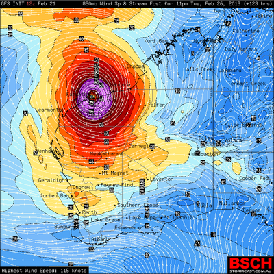
kaart van dinsdag 26 februari
Aan de noordwestkant van Australië zal een cycloon ontstaan die kan uitgroeien tot een zogenaamde 'major' hurricane (categorie 3 of hoger). Vanaf komende zaterdag gaat dit systeem zich steeds verder ontwikkelen en zal mogelijk diezelfde dag of zondag de orkaan status bereiken.
De meeste modellen laten de cycloon vervolgens ergens langs de noordwestkust landfall maken. Australië is geen dichtbevolkt land (het is niet de oostkust van de VS), de stad die zich moet gaan voorbereiden is Port Hedland en heeft 12000 inwoners. Maar ook steden als Broom en Derby moeten rekening houden met dit systeem.
Na de landfall lijkt het binnenland aan de beurt, met als gevolg overstromingen, aardverschuivingen, storm en bliksemschade.
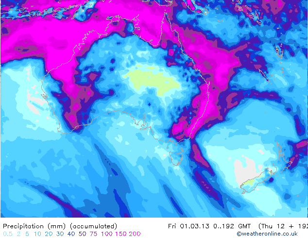
opgetelde neerslag in mm
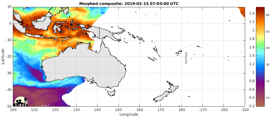
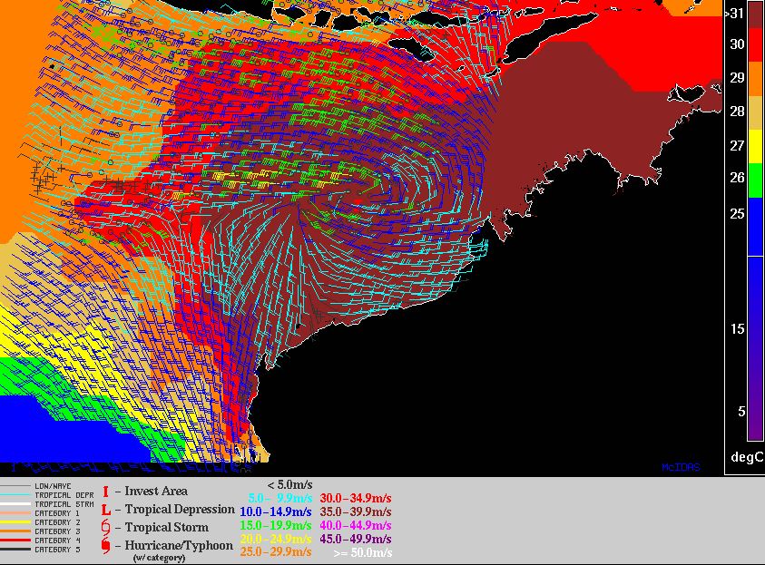
hieronder is te zien dat er een draaibeweging ontstaat boven Australie
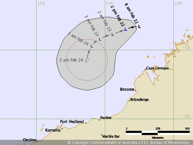
De waarschuwing van Australian Government Bureau of Meteorology (BOM)
kaart van dinsdag 26 februari
Aan de noordwestkant van Australië zal een cycloon ontstaan die kan uitgroeien tot een zogenaamde 'major' hurricane (categorie 3 of hoger). Vanaf komende zaterdag gaat dit systeem zich steeds verder ontwikkelen en zal mogelijk diezelfde dag of zondag de orkaan status bereiken.
De meeste modellen laten de cycloon vervolgens ergens langs de noordwestkust landfall maken. Australië is geen dichtbevolkt land (het is niet de oostkust van de VS), de stad die zich moet gaan voorbereiden is Port Hedland en heeft 12000 inwoners. Maar ook steden als Broom en Derby moeten rekening houden met dit systeem.
Na de landfall lijkt het binnenland aan de beurt, met als gevolg overstromingen, aardverschuivingen, storm en bliksemschade.
opgetelde neerslag in mm
hieronder is te zien dat er een draaibeweging ontstaat boven Australie
De waarschuwing van Australian Government Bureau of Meteorology (BOM)
quote:A low [10U] in the Northern Region near 11S 129E is slowly developing and is
expected to move into the Western Region during Friday or early Saturday. This
low may develop into a tropical cyclone late on Saturday or on Sunday. Next
week there is a significant risk that this system will become a severe tropical
cyclone and impact the Pilbara or West Kimberley. People in the Pilbara and
Kimberley are advised to stay up to date with weather forecasts and warnings.
There are no other significant lows and none are expected to develop over the
next three days.
Likelihood of this system being a tropical cyclone in the Western Region on:
Friday Low
Saturday Moderate
Sunday High

Ook Perth (1.8 miljoen inwoners) krijgt mogelijk te maken met deze cycloon. Volgens ECMWF kan hier zeer veel neerslag gaan vallen.

De verschillende modellen onder elkaar laten allemaal een landfall zien ergens in het noordwesten van Australië.

Onderstaande plaatje laat een andere categorie zien dan de gebruikelijke Schaal van Saffir-Simpson. Categorie 1 is hier te vergelijken met een windkracht 8 / 9.
Zie ook de tabel die in WKN / Hurricane Season 2013 #1 staat.
Zie ook de tabel die in WKN / Hurricane Season 2013 #1 staat.
quote:Potential Cyclones:
A weak low [10U] is located in the monsoon trough near 13S 122E at midday WST,
about 500km north of Broome. The low is forecast to develop and become a
tropical cyclone on Sunday. Further intensification is then expected and there
is a significant risk that this system will become a severe tropical cyclone
and impact the Pilbara or West Kimberley early next week. People in the Pilbara
and Kimberley are advised to stay up to date with weather forecasts and
warnings.
Likelihood of this system being a tropical cyclone in the Western Region on:
Saturday Low
Sunday High
Monday High

Systeem begint zich nu te ontwikkelen. windstoten lopen op tot 85 km/uur. Luchtdruk is gedaald naar 996 Hpa.

quote:A low [10U] is located in the monsoon trough near 15S 119E at 8:00 WST,
about 440km northwest of Broome. The low is forecast to develop and become a
tropical cyclone on Sunday. Further intensification is then expected and there
is a significant risk that this system will become a severe tropical cyclone
and impact the Pilbara or West Kimberley early next week. Refer to latest
Tropical Cyclone Advice [IDW24100] for more details.
Likelihood of this system being a tropical cyclone in the Western Region on:
Sunday High
Monday High
Tuesday High

[ Bericht 5% gewijzigd door #ANONIEM op 23-02-2013 16:38:31 ]
De media in Australie hoor je amper over deze cycloon. Komt het omdat het niet de oostkust is. Ik lees wel iets over een cycloon die kan ontstaan bij Queensland, maar die kan ik niet terugvinden op weerkaarten. Die bij de noordwest kust lijkt me wel duidelijk. 

Ook in de media in Australië is wakker geworden.
GFS en ECMWF laten een iets ander beeld zien. De cycloon maakt niet direct landfall maar trekt even langs de kust om een stuk lager uiteindelijk landfall te maken. Wat resulteert in nog meer neerslag voor de kust.
GFS en ECMWF laten een iets ander beeld zien. De cycloon maakt niet direct landfall maar trekt even langs de kust om een stuk lager uiteindelijk landfall te maken. Wat resulteert in nog meer neerslag voor de kust.
quote:Cyclone threat to north coast of WA
RESIDENTS have been warned to prepare for dangerous weather as a cyclone intensifies off Western Australia's north coast.
Tropical Cyclone Rusty is expected to bring gales late on Sunday night or early on Monday, as it tracks towards the coast, followed by very heavy rain on Tuesday and Wednesday.
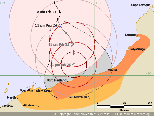
A blue alert for dangerous weather has been issued for coastal communities from Broome to Whim Creek, including areas around Port Hedland, Wallal and Broome.
At 2pm (WST) on Sunday, the category one cyclone was estimated to be 350km north of Port Hedland and 435km west of Broome, moving south at 8km/h, the Bureau of Meteorology said.
It will continue to intensify on Monday and there is a high risk that it will cross the coast as a severe tropical cyclone on Tuesday or Wednesday.
Tropical Cyclone Rusty is large and expected to move more slowly than usual, resulting in higher than normal rainfall, the bureau says.
Digital Pass $1 for first 28 Days
Widespread very heavy rainfall is expected on Tuesday and Wednesday and is likely to lead to major flooding in the De Grey catchment and in the Fortescue.
Residents have been warned to review their family cyclone plan and organise an emergency kit with a portable battery-operated radio, torch, spare batteries and first aid kit.
The Port Hedland Port Authority said anchorage evacuation had begun and inbound shipping movements had been suspended.
Outbound movements will continue as scheduled overnight, but could be amended if flying is made difficult.
25e is volle maan. De 27e is de landfall tijdens springtij, wat nog een extra verhoging van het water betekend.
quote:TROPICAL CYCLONE ADVICE NUMBER 7
Issued at 2:36 pm WST on Sunday 24 February 2013
A Cyclone WARNING is current for coastal areas from Wallal to Whim Creek.
A Cyclone WATCH is current for coastal areas from Broome to Wallal and Whim
Creek to Mardie and extending inland to Marble Bar.
At 2:00 pm WST Tropical Cyclone Rusty, Category 1 was estimated to be
350 kilometres north of Port Hedland and
435 kilometres west of Broome and
moving south at 8 kilometres per hour.
Tropical Cyclone Rusty is moving slowly towards the coast. Gales are expected
to commence on the coast late on Sunday night or early on Monday.
During Monday the system will continue to intensify and there is a high risk
that it will cross the coast as a severe tropical cyclone on Tuesday or
Wednesday.
Rusty is a large tropical cyclone and is expected to move slower than usual
resulting in higher than usual rainfall. Widespread very heavy rainfall is
expected during Tuesday and Wednesday and is likely to lead to major flooding
in the De Grey catchment. Significant flooding in the Fortescue is also likely.
DFES State Emergency Service (SES) advises of the following community alerts:
BLUE ALERT: People in communities between Broome and Whim Creek need to prepare
for cyclonic weather and organise an emergency kit including first aid kit,
torch, portable radio, spare batteries, food and water.
People between Whim Creek and Mardie should listen for the next advice.
Details of Tropical Cyclone Rusty at 2:00 pm WST:
.Centre located near...... 17.2 degrees South 118.2 degrees East
.Location accuracy........ within 55 kilometres
.Recent movement.......... towards the south at 8 kilometres per hour
.Wind gusts near centre... 95 kilometres per hour
.Severity category........ 1
.Central pressure......... 988 hectoPascals


Ik denk zelf minimaal cat 2.quote:
 Op
Op JTWC komt met 85 kts, dat is een cat 2. Vaak wordt dat nog wel aangepast.
[ Bericht 7% gewijzigd door #ANONIEM op 24-02-2013 11:29:27 ]

JTWC komt nu met 95 kts over 72 uur. Dat is bijna een categorie 3 (vanaf 96 kts).
quote:72 HRS, VALID AT:
271200Z --- 20.2S 118.5E
MAX SUSTAINED WINDS - 095 KT, GUSTS 115 KT
WIND RADII VALID OVER OPEN WATER ONLY
Denk dat het inmiddels al een cat 1 is. Het systeem groeit enorm momenteel. Luchtdruk is gedaald naar 980 Hpa.
quote:People between Whim Creek and Mardie and inland parts of the central and
eastern Pilbara should listen for the next advice.
Details of Tropical Cyclone Rusty at 11:00 pm WST:
.Centre located near...... 17.4 degrees South 118.2 degrees East
.Location accuracy........ within 55 kilometres
.Recent movement.......... towards the south at 5 kilometres per hour
.Wind gusts near centre... 120 kilometres per hour
.Severity category........ 1
.Central pressure......... 980 hectoPascals


900 mb is al geregistreerdquote:Op zondag 24 februari 2013 20:23 schreef aloa het volgende:
914 mbDat is een cat 4 / 5.
[ afbeelding ]
🐱


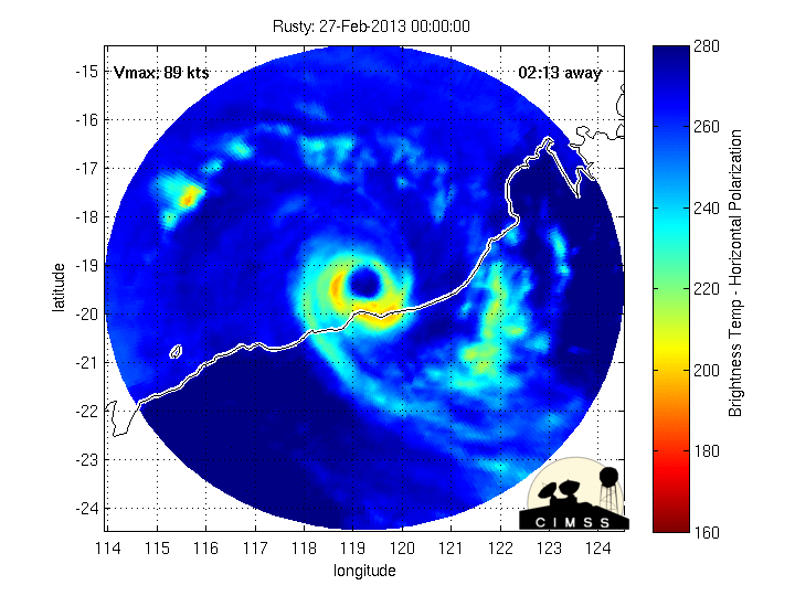
Kimbolton zit nu op meer dan 100 mm (115) aan neerslag en dat zal nog verder oplopen. Rusty is inmiddels een categorie 1 met een windveld boven de 120 km/u en windstoten tot 145 km/u.
quote:Australia's most dangerous tropical cyclone of the season so far is Tropical Cyclone Rusty, which has intensified to Category 1 strength and is lumbering southeastwards towards the northwestern coast of Australia at 6 mph. Rusty is expected to intensify further into a powerful Category 3 storm, and is predicted to make landfall near the town of Port Hedland (population 15,000) on Tuesday near 18 UTC (1 pm EST in the U.S.) Rusty formed on Saturday evening when westerly winds blowing near the Equator combined with easterly winds blowing south of New Guinea to create an unusually large tropical storm with a huge, 100-mile diameter cloud-free center. Ordinarily, a storm this large takes a long time to wind up, but Rusty intensified quickly, taking advantage of low wind shear of 5 - 10 knots, and near-record warm ocean temperatures of 31 - 32°C (88 - 90°F). It's not often that a tropical cyclone gets 31 - 32°C waters to feed off of; these temperature are about 1.5°C (2.7°F) warmer than average for this time of year. The hot ocean temperatures are largely due to Australia's hottest month in its history--the nationally-averaged monthly maximum temperature during January 2013 was the highest ever recorded. For the waters off the northwest Australian coast (15°S - 20°S, 115°E - 120°E), only two years since ocean temperature records began in 1960 have seen February ocean temperatures this warm (1.57°C above average in 2005, and 1.62°C above average in 1983.) The warm waters also extend to great depth; the tropical cyclone heat potential (TCHP) in this region is over 90 kJ/cm**2, a value commonly associated with rapid intensification. With its slow movement, large circulation, and near-record warm waters to feed off, Rusty is going to dump some prodigious rains on the coast of northwestern Australia over the next few days. Radar out of Port Hedland shows very heavy rains already affecting the coast, and sustained wind as high as 38 mph have been observed there today.
http://www.wunderground.c(...)t.html?entrynum=2355
Rusty ligt bijna stationair voor de kust van Australië, wat voor extreem veel neerslag zal zorgen.
Systeem lijkt nog te intensiveren tot een categorie 2.
Systeem lijkt nog te intensiveren tot een categorie 2.


quote:Monstercycloon Rusty geselt grootste haven Australië
Een reusachtige orkaan geselt momenteel Port Hedland, de belangrijkste en grootste haven van Australië. Monsterstorm Rusty werd opgewaardeerd naar een tropische cycloon van categorie 4, het op een na hoogste niveau. Door windpieken boven de 200 km/u (tot 230 km/u rond het oog van de storm) en overvloedige regen wordt in het dunbevolkte gebied aan de noordwestkust van Australië gevreesd voor grote schade. Er werd dan ook groot alarm geslagen en iedereen wordt bevolen binnen te blijven.
In deze tijd van het jaar zijn cyclonen niet zeldzaam in het tropische noorden van Australië. Rusty heeft het gemunt op de noordwestelijke hoek van het uitgestrekte land. Dat gebied is dunbevolkt, maar de havenstad Port Hedland (met 14.000 inwoners) is de voorbije jaren dankzij grote ijzerertsvoorraden in de Pilbara-regio uitgegroeid tot de grootste haven van het land. Onder meer Vlaamse investeringen bloeien in Port Hedland.
Grootschalige overstromingen
Het begon al vanmorgen met windstoten boven 120 km/u, maar in de loop van de dag nam Rusty nog in kracht toe. Op zijn hoogtepunt zal de orkaan van categorie 4 windpieken tot 200 km/u ontketenen. De gigantische omvang en het trage opschuiven van de monsterstorm veroorzaken niet enkel verwoestende windkracht maar ook overvloedige regenval. Er wordt dan ook gevreesd voor grootschalige overstromingen. Omdat die regen de vegetatie al week heeft gemaakt, zouden heel wat bomen ontworteld kunnen worden. Een kustlijn van vele honderden kilometers krijgt de volle laag van het noodweer.
Nu Sandra
Tropische cyclonen zijn het gevaarlijkst wanneer ze aan land gaan. Het zeewater moet warm zijn (minstens 26 graden) om ze te doen ontstaan. Eens op het land verzwakken tropische cyclonen omdat ze dan minder vocht en hitte kunnen oppikken in vergelijking met de periode dat ze boven de oceaan sleepten. De namen van de cyclonen worden (alfabetisch) gekozen uit een lijst van 104. Na Rusty is het de beurt aan Sandra.


|
|