WKN Weer, Klimaat en Natuurrampen
Lees alles over het onstuimige weer op onze planeet, volg orkanen en tornado's, zie hoe vulkanen uitbarsten en hoe Moeder Aarde beeft bij een aardbeving. Alles over de verwoestende kracht van onze planeet en tal van andere natuurverschijnselen.


Weet iemand of er net een mini aardbeving was of gewoon belachelijk harde onweer? Ik werd wakker en de ramen trilde.. Arnhem..
Op vrijdag 4 november 2011 09:39 schreef Blik het volgende:
"Sinds wanneer is maart de derde maand van het jaar?"
61% van alle statistieken zijn nutteloos.
Vind je dat ik een internet verdien? Klik hier!
"Sinds wanneer is maart de derde maand van het jaar?"
61% van alle statistieken zijn nutteloos.
Vind je dat ik een internet verdien? Klik hier!
Onweerquote:Op dinsdag 5 februari 2013 06:37 schreef delano.888 het volgende:
Weet iemand of er net een mini aardbeving was of gewoon belachelijk harde onweer? Ik werd wakker en de ramen trilde.. Arnhem..
Teleurstellend. HARD dat het ging!quote:
Op vrijdag 4 november 2011 09:39 schreef Blik het volgende:
"Sinds wanneer is maart de derde maand van het jaar?"
61% van alle statistieken zijn nutteloos.
Vind je dat ik een internet verdien? Klik hier!
"Sinds wanneer is maart de derde maand van het jaar?"
61% van alle statistieken zijn nutteloos.
Vind je dat ik een internet verdien? Klik hier!
Er is een tsunamiwaarschuwing.quote:
Zojuist een 8.0 nabij de Solomon Islands
Herman Finkers... He buurman, ik hier ?
twitter:eruptionsblog twitterde op woensdag 06-02-2013 om 02:39:43 Interesting that a M6.3 occurred within 20 km of this M8 less than an hour ago: http://t.co/heyrA4xJ reageer retweet
 Interesting that a M6.3 occurred within 20 km of this M8 less than an hour ago:
 twitter:Geo_Risk twitterde op woensdag 06-02-2013 om 02:57:44 Tsunami on going at Lata Wharf Station, Salomon , Epicentral Z. http://t.co/6kzylrMu / @CPPGeophysics @eruptionsblog reageer retweet
 Tsunami on going at Lata Wharf Station, Salomon , Epicentral Z.
 twitter:newsbreaker twitterde op woensdag 06-02-2013 om 03:07:41 BREAKING: Tsunami destroys villages in Solomon Islands after mag 8.0 quake, hospital official tells AFP - @passantino reageer retweet
 BREAKING: Tsunami destroys villages in Solomon Islands after mag 8.0 quake, hospital official tells AFP - @
<a href="http://goo.gl/q8fhTe" target="_blank">FAQ?</a>
<a href="http://goo.gl/gYvZFq" target="_blank">Geel is een zonnige en vrolijke kleur, als hij tenminste enigszins warm is gekleurd en wat naar het oranje neigt</a>
<a href="http://goo.gl/gYvZFq" target="_blank">Geel is een zonnige en vrolijke kleur, als hij tenminste enigszins warm is gekleurd en wat naar het oranje neigt</a>
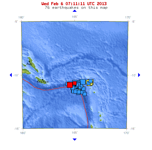
Het gaat maar doorquote:MAP 5.6 2013/02/06 06:53:20 -10.635 164.967 10.0 SANTA CRUZ ISLANDS REGION
MAP 6.3 2013/02/06 06:35:20 -10.784 164.512 10.1 SANTA CRUZ ISLANDS REGION
MAP 5.2 2013/02/06 06:09:37 -11.071 164.811 10.0 SANTA CRUZ ISLANDS REGION
MAP 5.2 2013/02/06 06:02:37 -10.780 164.571 10.0 SANTA CRUZ ISLANDS REGION
MAP 5.2 2013/02/06 05:48:54 -11.066 164.756 10.3 SANTA CRUZ ISLANDS REGION
MAP 5.0 2013/02/06 05:35:34 -10.745 165.326 15.0 SANTA CRUZ ISLANDS
MAP 5.1 2013/02/06 05:30:19 -10.682 164.272 9.8 SANTA CRUZ ISLANDS REGION
MAP 5.1 2013/02/06 05:24:31 -11.433 165.367 15.1 SANTA CRUZ ISLANDS
MAP 5.3 2013/02/06 05:16:27 -10.426 166.498 11.9 SANTA CRUZ ISLANDS
MAP 5.2 2013/02/06 05:13:49 -10.620 166.298 15.1 SANTA CRUZ ISLANDS
MAP 5.2 2013/02/06 05:01:51 -11.408 165.057 9.9 SANTA CRUZ ISLANDS
MAP 5.0 2013/02/06 04:56:19 -11.302 165.130 16.0 SANTA CRUZ ISLANDS
MAP 5.1 2013/02/06 04:34:51 -11.396 164.847 35.2 SANTA CRUZ ISLANDS REGION
MAP 5.2 2013/02/06 04:20:55 -10.910 165.571 34.9 SANTA CRUZ ISLANDS
MAP 5.0 2013/02/06 04:20:04 -10.883 165.405 10.1 SANTA CRUZ ISLANDS
MAP 5.0 2013/02/06 04:16:30 -11.092 164.904 10.7 SANTA CRUZ ISLANDS REGION
MAP 5.6 2013/02/06 03:49:47 -10.893 165.474 18.3 SANTA CRUZ ISLANDS
MAP 5.3 2013/02/06 03:45:10 -10.669 165.312 33.4 SANTA CRUZ ISLANDS
MAP 5.2 2013/02/06 03:38:55 -10.890 165.268 12.1 SANTA CRUZ ISLANDS
MAP 5.3 2013/02/06 03:28:55 -11.053 165.446 22.8 SANTA CRUZ ISLANDS
MAP 5.1 2013/02/06 03:25:19 -11.130 165.806 9.9 SANTA CRUZ ISLANDS
MAP 5.3 2013/02/06 03:19:06 -10.896 165.216 14.9 SANTA CRUZ ISLANDS
MAP 5.2 2013/02/06 03:11:53 -10.935 165.292 36.8 SANTA CRUZ ISLANDS
MAP 5.1 2013/02/06 03:06:34 -11.513 165.326 10.0 SANTA CRUZ ISLANDS
MAP 5.6 2013/02/06 03:01:03 -11.032 165.106 20.4 SANTA CRUZ ISLANDS
MAP 5.5 2013/02/06 02:58:22 -10.663 165.128 16.9 SANTA CRUZ ISLANDS
MAP 5.1 2013/02/06 02:57:45 -10.755 165.026 38.1 SANTA CRUZ ISLANDS
MAP 5.6 2013/02/06 02:30:49 -10.822 164.980 32.5 SANTA CRUZ ISLANDS REGION
MAP 5.3 2013/02/06 02:23:12 -10.963 165.402 28.3 SANTA CRUZ ISLANDS
MAP 5.2 2013/02/06 02:18:15 -11.468 165.614 34.4 SANTA CRUZ ISLANDS
MAP 5.2 2013/02/06 02:06:21 -10.597 165.363 10.0 SANTA CRUZ ISLANDS
MAP 6.6 2013/02/06 01:54:15 -10.514 165.733 10.2 SANTA CRUZ ISLANDS
MAP 5.7 2013/02/06 01:48:43 -11.628 165.937 10.0 SANTA CRUZ ISLANDS
MAP 5.6 2013/02/06 01:33:37 -10.922 165.085 10.0 SANTA CRUZ ISLANDS
MAP 6.4 2013/02/06 01:23:20 -11.232 164.921 10.1 SANTA CRUZ ISLANDS REGION
MAP 5.6 2013/02/06 01:22:13 -11.366 165.768 10.1 SANTA CRUZ ISLANDS
MAP 8.0 2013/02/06 01:12:27 -10.738 165.138 28.7 SANTA CRUZ ISLANDS
MAP 5.3 2013/02/06 00:46:01 -10.871 165.029 9.5 SANTA CRUZ ISLANDS
MAP 6.3 2013/02/06 00:07:23 -10.858 165.206 10.0 SANTA CRUZ ISLANDS
Nou... een 8.0 heeft hopelijk de druk verminderd of er komt er nog één achteraan...quote:
Druk bij de Santa Cruz Eilanden...volgens mij zojuist een 6.7...
en eerder al ...
[..]
quote:At least 5 killed after tsunami strikes the Solomon Islands
REUTERS - A powerful 8.0 magnitude earthquake set off a tsunami that killed at least five people in a remote part of the Solomon Islands on Wednesday and triggered evacuations across the South Pacific as island nations issued tsunami alerts.
The quake struck 340 km (211 miles) east of Kira Kira in the Solomons, the Pacific Tsunami Warning Center in Hawaii said as it issued warnings for the Solomons and other South Pacific nations including Australia and New Zealand. It later cancelled the warnings for the outlying regions.
A tsunami measuring 0.9 metres (three feet) hit near the town of Lata on the remote Santa Cruz island, swamping some villages and the town's main airport as people fled to safety on higher ground.
More than three dozen aftershocks up to magnitude 6.6 rocked the region in the hours after the quake, the U.S. Geological Survey said.
Lata hospital's director of nursing, Augustine Pilve, told New Zealand television that five people had been killed, including a boy about 10 years old, adding that more casualties were possible as officials made their way to at least three villages that may have been hit.
"It's more likely that other villages along the coast of Santa Cruz may be affected," he said.
Disaster officials in the Solomon Islands capital Honiara told the Solomon Islands Broadcasting Corp. that they believed six people were dead and that five villages had suffered damage.
Solomon Islands Police Commissioner John Lansley said it was too early to fully assess the damage or casualty numbers, and said authorities hoped to send aircraft to the region on Thursday to help determine the extent of the damage.
Luke Taula, a fisheries officer in Lata, said he watched the tsunami as it came in small tidal surges rather than as one large wave.
"We have small waves come in, then go out again, then come back in. The waves have reached the airport terminal," he told Reuters by telephone.
The worst damage was to villages on the western side of a point that protects the main township, he said.
"There are reports that some communities have been badly hit, their houses have been damaged by the waves."
About 5,000 people lived in and around the town, but the area was deserted as people fled to higher ground, Taula said.
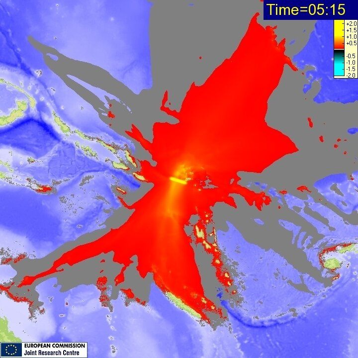
Plaatje is zeker de tsunami - gezien de volgende twitterpost
http://www.iris.edu/hq/fi(...)06_Islas_Salomon.pdf
quote:simulatie van de maximale hoogte en de verspreiding van de tsunami op de Salomonseilanden. De maximale hoogte is 2 meter.
En een spaans rapport over de beving(en)twitter:teideano twitterde op woensdag 06-02-2013 om 13:20:35 simulación de la altura máxima y dispersión del tsunami de las islas salomón. La altura máxima ha sido de 2 metros. http://t.co/Rq3xGzvy reageer retweet
 simulación de la altura máxima y dispersión del tsunami de las islas salomón. La altura máxima ha sido de 2 metros.
 http://www.iris.edu/hq/fi(...)06_Islas_Salomon.pdf
<a href="http://goo.gl/q8fhTe" target="_blank">FAQ?</a>
<a href="http://goo.gl/gYvZFq" target="_blank">Geel is een zonnige en vrolijke kleur, als hij tenminste enigszins warm is gekleurd en wat naar het oranje neigt</a>
<a href="http://goo.gl/gYvZFq" target="_blank">Geel is een zonnige en vrolijke kleur, als hij tenminste enigszins warm is gekleurd en wat naar het oranje neigt</a>
Aardig wat actie de laatste tijd in de noord atlantische rug.
24-01-2013
05-02-2013
En "net" weer
06-02-2013
24-01-2013
05-02-2013
En "net" weer
06-02-2013
<a href="http://www.vwkweb.nl/" rel="nofollow" target="_blank">[b]Vereniging voor weerkunde en klimatologie[/b]</a>
<a href="http://www.estofex.org/" rel="nofollow" target="_blank">[b]ESTOFEX[/b]</a>
<a href="http://www.estofex.org/" rel="nofollow" target="_blank">[b]ESTOFEX[/b]</a>
Ik heb zo'n gevoel dat er op korte termijn echt weer een desastreuze aardbeving gaat plaatsvinden.
“Rather than love, than money, than fame, give me truth.”
twitter:teideano twitterde op donderdag 07-02-2013 om 10:42:00 salomon islands #earthquake mag. downgraded to 7,9. Two aftershocks upgraded to 7.1 and 7.0. Top 3 quakes of 2013!!! reageer retweet
twitter:CPPGeophysics twitterde op woensdag 06-02-2013 om 21:44:24 Graph of foreshock sequence of Santa Cruz Islands quake (bit messy, no time to clean up) http://t.co/WPUo6JM7 reageer retweet
 Graph of foreshock sequence of Santa Cruz Islands quake (bit messy, no time to clean up)
[ Bericht 35% gewijzigd door bwt op 07-02-2013 17:41:52 ]
<a href="http://goo.gl/q8fhTe" target="_blank">FAQ?</a>
<a href="http://goo.gl/gYvZFq" target="_blank">Geel is een zonnige en vrolijke kleur, als hij tenminste enigszins warm is gekleurd en wat naar het oranje neigt</a>
<a href="http://goo.gl/gYvZFq" target="_blank">Geel is een zonnige en vrolijke kleur, als hij tenminste enigszins warm is gekleurd en wat naar het oranje neigt</a>
Ik heb een aardbevings plug-in voor google earth.quote:
Ik zie op RSOE EDIS dat het goed door blijft beven daar, er is werderom een tsunamiwaarschuwing.
En het ziet er rood van de bevingen
<a href="http://www.vwkweb.nl/" rel="nofollow" target="_blank">[b]Vereniging voor weerkunde en klimatologie[/b]</a>
<a href="http://www.estofex.org/" rel="nofollow" target="_blank">[b]ESTOFEX[/b]</a>
<a href="http://www.estofex.org/" rel="nofollow" target="_blank">[b]ESTOFEX[/b]</a>


http://www.rtvnoord.nl/artikel/artikel.asp?p=117833
Meldingen van scheuren in muren en de schok is zowel gevoeld als gehoord. Heftiger dan de vorige paar keren als ik het zo lees.
Meldingen van scheuren in muren en de schok is zowel gevoeld als gehoord. Heftiger dan de vorige paar keren als ik het zo lees.
En zojuist berichten van een tweede beving rond 00:19, gevoeld in de stad Groningen, mogelijk zwaarder dan die van n uur geleden
<a href="http://www.vwkweb.nl/" rel="nofollow" target="_blank">[b]Vereniging voor weerkunde en klimatologie[/b]</a>
<a href="http://www.estofex.org/" rel="nofollow" target="_blank">[b]ESTOFEX[/b]</a>
<a href="http://www.estofex.org/" rel="nofollow" target="_blank">[b]ESTOFEX[/b]</a>
Heb ze hier beiden niet gevoeld (Groningen-Zuid). In tegenstelling tot die van augustus 2012quote:
En zojuist berichten van een tweede beving rond 00:19, gevoeld in de stad Groningen, mogelijk zwaarder dan die van n uur geleden
<a href="http://goo.gl/q8fhTe" target="_blank">FAQ?</a>
<a href="http://goo.gl/gYvZFq" target="_blank">Geel is een zonnige en vrolijke kleur, als hij tenminste enigszins warm is gekleurd en wat naar het oranje neigt</a>
<a href="http://goo.gl/gYvZFq" target="_blank">Geel is een zonnige en vrolijke kleur, als hij tenminste enigszins warm is gekleurd en wat naar het oranje neigt</a>
Kamp zei gisteren nog in een Kameroverleg dat de kans op een beving van deze sterkte in groningen binnen een jaar 1 op 14 is. Dezelfde dag nog dus.quote:
Kein gewalt! Wir sind das volk!
Steps taken forwards but sleepwalking back again.
''And the Germans kill the Jews, And the Jews kill the Arabs, And the Arabs kill the hostages
And that is the news.''
Steps taken forwards but sleepwalking back again.
''And the Germans kill the Jews, And the Jews kill the Arabs, And the Arabs kill the hostages
And that is the news.''
De wereld gaat in 2'en splitsen 
Neh effe serieus, die klote gaswinning moet stoppen voor er ongelukken gebeuren daar in grunn.
Gisteren nog in het nieuws geweest dat ze eind dit jaar met uitspraak komen..veel te lang
Neh effe serieus, die klote gaswinning moet stoppen voor er ongelukken gebeuren daar in grunn.
Gisteren nog in het nieuws geweest dat ze eind dit jaar met uitspraak komen..veel te lang
Doe mee met het voorspellen van het weer!
Weekvoorspelling | Week 12 (invullen tot 16-03 - 11:59)
Maandvoorspelling Maart (Inzendingen gesloten)
Jaarvoorspelling 2025 / 2026
Weekvoorspelling | Week 12 (invullen tot 16-03 - 11:59)
Maandvoorspelling Maart (Inzendingen gesloten)
Jaarvoorspelling 2025 / 2026
staat er nog iets overeind?
MAP 5.3 2013/02/08 09:09:02 -10.914 164.739 10.0 SANTA CRUZ ISLANDS REGION
MAP 5.3 2013/02/08 08:03:36 -11.030 165.672 10.0 SANTA CRUZ ISLANDS
MAP 5.3 2013/02/08 04:26:17 -11.096 165.730 15.4 SANTA CRUZ ISLANDS
MAP 5.1 2013/02/08 00:12:58 -11.738 165.462 15.4 SANTA CRUZ ISLANDS
MAP 5.1 2013/02/07 21:40:56 -10.901 165.738 25.5 SANTA CRUZ ISLANDS
MAP 5.1 2013/02/07 21:38:25 -4.377 142.992 97.8 NEW GUINEA, PAPUA NEW GUINEA
MAP 5.0 2013/02/07 20:45:19 -10.909 165.773 10.0 SANTA CRUZ ISLANDS
MAP 5.2 2013/02/07 20:20:07 -10.855 165.706 10.0 SANTA CRUZ ISLANDS
MAP 5.5 2013/02/07 19:48:19 -10.872 165.717 10.2 SANTA CRUZ ISLANDS
MAP 5.0 2013/02/07 19:25:15 -10.983 165.677 9.9 SANTA CRUZ ISLANDS
MAP 6.6 2013/02/07 18:59:16 -11.001 165.658 10.0 SANTA CRUZ ISLANDS
MAP 5.1 2013/02/07 17:49:47 -11.238 165.921 14.2 SANTA CRUZ ISLANDS
MAP 5.0 2013/02/07 15:05:11 -11.010 165.587 35.0 SANTA CRUZ ISLANDS
MAP 5.0 2013/02/07 14:05:56 -11.028 164.816 10.1 SANTA CRUZ ISLANDS REGION
MAP 5.1 2013/02/07 12:36:49 -10.823 165.173 10.2 SANTA CRUZ ISLANDS
MAP 6.1 2013/02/07 08:03:41 -11.025 164.750 10.0 SANTA CRUZ ISLANDS REGION
MAP 5.1 2013/02/07 07:19:51 -15.586 -173.142 10.0 TONGA
MAP 5.3 2013/02/07 07:11:20 -10.972 165.492 10.0 SANTA CRUZ ISLANDS
MAP 5.0 2013/02/07 03:52:57 -11.669 165.050 35.0 SANTA CRUZ ISLANDS
MAP 5.2 2013/02/07 02:17:25 -10.636 164.823 52.0 SANTA CRUZ ISLANDS REGION
MAP 5.2 2013/02/07 01:00:49 -11.819 164.824 34.2 SANTA CRUZ ISLANDS REGION
MAP 5.1 2013/02/07 00:56:47 -11.667 164.782 35.1 SANTA CRUZ ISLANDS REGION
MAP 5.1 2013/02/07 00:41:32 1.425 98.935 82.8 NORTHERN SUMATRA, INDONESIA
MAP 6.2 2013/02/07 00:30:11 -11.664 164.960 9.8 SANTA CRUZ ISLANDS REGION
MAP 5.2 2013/02/06 23:49:35 -11.770 164.942 10.5 SANTA CRUZ ISLANDS REGION
MAP 5.0 2013/02/06 23:39:01 -11.767 164.787 10.5 SANTA CRUZ ISLANDS REGION
MAP 5.0 2013/02/06 23:30:28 -10.775 165.033 10.2 SANTA CRUZ ISLANDS
MAP 5.0 2013/02/06 22:24:27 -10.957 165.441 10.0 SANTA CRUZ ISLANDS
MAP 5.5 2013/02/06 22:20:18 -11.091 165.666 9.9 SANTA CRUZ ISLANDS
MAP 5.5 2013/02/06 22:12:18 -1.483 100.322 11.3 SOUTHERN SUMATRA, INDONESIA
MAP 5.1 2013/02/06 20:42:31 -23.225 170.855 10.2 SOUTHEAST OF THE LOYALTY ISLANDS
MAP 5.0 2013/02/06 20:18:40 46.506 -27.373 14.1 NORTHERN MID-ATLANTIC RIDGE
MAP 5.0 2013/02/06 18:03:20 -11.178 165.628 10.1 SANTA CRUZ ISLANDS
MAP 5.0 2013/02/06 17:19:32 -11.645 165.037 10.1 SANTA CRUZ ISLANDS
MAP 5.0 2013/02/06 17:04:08 -10.693 164.886 10.0 SANTA CRUZ ISLANDS REGION
MAP 5.0 2013/02/06 16:39:30 -10.678 164.812 10.0 SANTA CRUZ ISLANDS REGION
MAP 5.0 2013/02/06 16:35:54 -11.295 165.632 10.1 SANTA CRUZ ISLANDS
MAP 5.3 2013/02/06 15:54:15 -10.931 165.428 10.1 SANTA CRUZ ISLANDS
MAP 5.0 2013/02/06 15:30:25 -10.812 164.487 10.0 SANTA CRUZ ISLANDS REGION
MAP 5.1 2013/02/06 14:24:05 -11.252 165.116 10.0 SANTA CRUZ ISLANDS
MAP 5.3 2013/02/06 14:20:57 -10.947 165.442 10.0 SANTA CRUZ ISLANDS
MAP 5.0 2013/02/06 14:03:51 -11.345 165.069 10.0 SANTA CRUZ ISLANDS
MAP 6.0 2013/02/06 13:54:54 -10.798 166.492 10.1 SANTA CRUZ ISLANDS
MAP 5.3 2013/02/06 13:50:33 -10.533 166.385 10.0 SANTA CRUZ ISLANDS
MAP 5.5 2013/02/06 12:44:29 -11.582 165.499 9.8 SANTA CRUZ ISLANDS
MAP 5.9 2013/02/06 11:53:54 -11.255 165.734 9.9 SANTA CRUZ ISLANDS
MAP 5.1 2013/02/06 11:24:03 -10.798 164.580 9.9 SANTA CRUZ ISLANDS REGION
MAP 5.6 2013/02/06 11:03:46 -10.730 165.137 9.8 SANTA CRUZ ISLANDS
MAP 5.7 2013/02/06 10:33:18 -10.636 164.808 9.9 SANTA CRUZ ISLANDS REGION
MAP 5.5 2013/02/06 10:20:34 -10.870 165.272 10.0 SANTA CRUZ ISLANDS
MAP 5.3 2013/02/06 10:12:30 -11.115 165.379 10.0 SANTA CRUZ ISLANDS
MAP 5.2 2013/02/06 09:24:00 -10.718 164.228 9.6 SANTA CRUZ ISLANDS REGION
MAP 5.0 2013/02/06 08:45:05 -11.670 165.468 10.3 SANTA CRUZ ISLANDS
MAP 5.0 2013/02/06 08:04:36 -15.988 -172.223 34.0 SAMOA ISLANDS REGION
MAP 5.0 2013/02/06 07:23:12 -10.901 165.356 10.1 SANTA CRUZ ISLANDS
MAP 5.3 2013/02/06 07:13:48 -10.637 165.305 10.1 SANTA CRUZ ISLANDS
MAP 5.6 2013/02/06 06:53:20 -10.635 164.967 10.0 SANTA CRUZ ISLANDS REGION
MAP 6.3 2013/02/06 06:35:20 -10.784 164.512 10.1 SANTA CRUZ ISLANDS REGION
MAP 5.2 2013/02/06 06:09:37 -11.071 164.811 10.0 SANTA CRUZ ISLANDS REGION
MAP 5.2 2013/02/06 06:02:37 -10.780 164.571 10.0 SANTA CRUZ ISLANDS REGION
MAP 5.2 2013/02/06 05:48:54 -11.066 164.756 10.3 SANTA CRUZ ISLANDS REGION
MAP 5.0 2013/02/06 05:35:34 -10.745 165.326 15.0 SANTA CRUZ ISLANDS
MAP 5.1 2013/02/06 05:30:19 -10.682 164.272 9.8 SANTA CRUZ ISLANDS REGION
MAP 5.1 2013/02/06 05:24:31 -11.433 165.367 15.1 SANTA CRUZ ISLANDS
MAP 5.3 2013/02/06 05:16:27 -10.426 166.498 11.9 SANTA CRUZ ISLANDS
MAP 5.2 2013/02/06 05:13:49 -10.620 166.298 15.1 SANTA CRUZ ISLANDS
MAP 5.2 2013/02/06 05:01:51 -11.408 165.057 9.9 SANTA CRUZ ISLANDS
MAP 5.0 2013/02/06 04:56:19 -11.302 165.130 16.0 SANTA CRUZ ISLANDS
MAP 5.1 2013/02/06 04:34:51 -11.396 164.847 35.2 SANTA CRUZ ISLANDS REGION
MAP 5.2 2013/02/06 04:20:55 -10.910 165.571 34.9 SANTA CRUZ ISLANDS
MAP 5.0 2013/02/06 04:20:04 -10.883 165.405 10.1 SANTA CRUZ ISLANDS
MAP 5.0 2013/02/06 04:16:30 -11.092 164.904 10.7 SANTA CRUZ ISLANDS REGION
MAP 5.6 2013/02/06 03:49:47 -10.893 165.474 18.3 SANTA CRUZ ISLANDS
MAP 5.3 2013/02/06 03:45:10 -10.669 165.312 33.4 SANTA CRUZ ISLANDS
MAP 5.2 2013/02/06 03:38:55 -10.890 165.268 12.1 SANTA CRUZ ISLANDS
MAP 5.3 2013/02/06 03:28:55 -11.053 165.446 22.8 SANTA CRUZ ISLANDS
MAP 5.1 2013/02/06 03:25:19 -11.130 165.806 9.9 SANTA CRUZ ISLANDS
MAP 5.3 2013/02/06 03:19:06 -10.896 165.216 14.9 SANTA CRUZ ISLANDS
MAP 5.2 2013/02/06 03:11:53 -10.935 165.292 36.8 SANTA CRUZ ISLANDS
MAP 5.1 2013/02/06 03:06:34 -11.513 165.326 10.0 SANTA CRUZ ISLANDS
MAP 5.6 2013/02/06 03:01:03 -11.032 165.106 20.4 SANTA CRUZ ISLANDS
MAP 5.5 2013/02/06 02:58:22 -10.663 165.128 16.9 SANTA CRUZ ISLANDS
MAP 5.1 2013/02/06 02:57:45 -10.755 165.026 38.1 SANTA CRUZ ISLANDS
MAP 5.6 2013/02/06 02:30:49 -10.822 164.980 32.5 SANTA CRUZ ISLANDS REGION
MAP 5.3 2013/02/06 02:23:12 -10.963 165.402 28.3 SANTA CRUZ ISLANDS
MAP 5.2 2013/02/06 02:18:15 -11.468 165.614 34.4 SANTA CRUZ ISLANDS
MAP 5.2 2013/02/06 02:06:21 -10.597 165.363 10.0 SANTA CRUZ ISLANDS
MAP 7.0 2013/02/06 01:54:15 -10.479 165.772 9.8 SANTA CRUZ ISLANDS
MAP 5.7 2013/02/06 01:48:43 -11.628 165.937 10.0 SANTA CRUZ ISLANDS
MAP 5.6 2013/02/06 01:33:37 -10.922 165.085 10.0 SANTA CRUZ ISLANDS
MAP 6.4 2013/02/06 01:23:20 -11.232 164.921 10.1 SANTA CRUZ ISLANDS REGION
MAP 5.6 2013/02/06 01:22:13 -11.366 165.768 10.1 SANTA CRUZ ISLANDS
MAP 8.0 2013/02/06 01:12:27 -10.738 165.138 28.7 SANTA CRUZ ISLANDS
MAP 5.3 2013/02/06 00:46:01 -10.871 165.029 9.5 SANTA CRUZ ISLANDS
MAP 6.3 2013/02/06 00:07:23 -10.858 165.206 10.0 SANTA CRUZ ISLANDS
quote:
Doe mee met het voorspellen van het weer!
Weekvoorspelling | Week 12 (invullen tot 16-03 - 11:59)
Maandvoorspelling Maart (Inzendingen gesloten)
Jaarvoorspelling 2025 / 2026
Weekvoorspelling | Week 12 (invullen tot 16-03 - 11:59)
Maandvoorspelling Maart (Inzendingen gesloten)
Jaarvoorspelling 2025 / 2026


En ze blijven lekker doorboren. Alsof gas belangrijker is dan de huizen van 950.000 mensen in de regio die er erg veel last van hebben.quote:
De wereld gaat in 2'en splitsen
Neh effe serieus, die klote gaswinning moet stoppen voor er ongelukken gebeuren daar in grunn.
Gisteren nog in het nieuws geweest dat ze eind dit jaar met uitspraak komen..veel te lang
Ja dus. Dat nog niemand aggeresief gereareerd heeft tegen de gasboringen.
🐱
Dit dus! Dat is nou juist het enige wat mij verbaast!quote:Op vrijdag 8 februari 2013 11:49 schreef GekkePoes het volgende:
[..]
Ja dus. Dat nog niemand agressief gereageerd heeft tegen de gasboringen.
Doe mee met het voorspellen van het weer!
Weekvoorspelling | Week 12 (invullen tot 16-03 - 11:59)
Maandvoorspelling Maart (Inzendingen gesloten)
Jaarvoorspelling 2025 / 2026
Weekvoorspelling | Week 12 (invullen tot 16-03 - 11:59)
Maandvoorspelling Maart (Inzendingen gesloten)
Jaarvoorspelling 2025 / 2026
twitter:SkyNewsBreak twitterde op vrijdag 08-02-2013 om 12:34:00 U.S. Geological Survey says a 7.1 magnitude earthquake has struck off the coast of Solomon Islands reageer retweet
 U.S. Geological Survey says a 7.1 magnitude earthquake has struck off the coast of Solomon Islands
Dare to unleash my rage..
That's my secret Captain... I'm always angry...
There's nothing like a trail of blood, to find your way back home.
That's my secret Captain... I'm always angry...
There's nothing like a trail of blood, to find your way back home.
Ze hebben al een 8.0 gehad.quote:
Gaat lekker daar op de Solomon eilanden, hopelijk geen voorbode voor een zwaardere aardbeving.
🐱
[quote] Op vrijdag 8 februari 2013 12:45 schreef Frutsel het volgende:
heavy naschok
al de 2e of 3e 7+ naschok
[/quote
deze??
7.1 2013/02/08 11:12:12 -10.925 165.875 10.0 SANTA CRUZ ISLANDS
Op vrijdag 8 februari 2013 12:45 schreef Frutsel het volgende:heavy naschok
al de 2e of 3e 7+ naschok
[/quote
deze??
7.1 2013/02/08 11:12:12 -10.925 165.875 10.0 SANTA CRUZ ISLANDS
Na de 8.0 kwam 40 minuten later de zwaarste naschok van 7.0, maar nu dus opeens 2 dagen later alsnog een 7.1.
Voor de 8.0 waren er al diverse 5+ en 6+ bevingen... stel je voor dat al die bevingen voorschokken zijn voor een 9+ die nog komtquote:
Na de 8.0 kwam 40 minuten later de zwaarste naschok van 7.0, maar nu dus opeens 2 dagen later alsnog een 7.1.
quote:Radio New Zealand, one of the best informed sources on the Solomon Islands, report a few moments ago :
- More than 3000 people are without shelter in the quake and tsunami-hit Santa Cruz island group in Solomon Islands, as significant aftershocks continue.
- The death toll has risen to 10 with the discovery of a child’s body in a ditch near Lata airport, with at least five more people missing.
- The Solomons government has declared a state of disaster with officials saying damage on the main island, Ndende, is much worse than first thought, with up to 20 villages swamped in a tsunami generated by the quake.
- The premier of Temotu province, Charles Brown Beu, says the number of homeless is expected to grow as rescuers reach more remote areas.
- Father Brown Beu says people fled again to higher ground after a 6.7 tremor on Friday morning, the largest following Wednesday’s 8.0-magnitude earthquake. (This was said BEFORE the latest dramatic aftershock closer to the island).
- He says people need food and water, and most urgently, waterproof shelters.
quote:7.0 25km SSE of Lata, Solomon Islands 2013-02-08 15:26:39 10.910°S 165.964°E 26.9
5.2 29km S of Lata, Solomon Islands 2013-02-08 15:00:12 10.984°S 165.867°E 10.1
5.2 27km S of Lata, Solomon Islands 2013-02-08 14:14:09 10.965°S 165.878°E 10.0
5.2 43km S of Lata, Solomon Islands 2013-02-08 14:10:38 11.108°S 165.872°E 10.0
4.8 21km SSE of Lata, Solomon Islands 2013-02-08 13:39:27 10.906°S 165.882°E 9.9
4.9 105km E of Lata, Solomon Islands 2013-02-08 13:28:09 10.852°S 166.785°E 10.1
5.1 28km S of Lata, Solomon Islands 2013-02-08 12:09:19 10.967°S 165.882°E 9.9
5.0 24km SE of Lata, Solomon Islands 2013-02-08 12:03:39 10.900°S 165.962°E 10.0
5.0 24km SSE of Lata, Solomon Islands 2013-02-08 11:56:11 10.918°S 165.929°E 10.1
5.1 26km SSE of Lata, Solomon Islands 2013-02-08 11:39:41 10.948°S 165.895°E 10.1
4.9 89km SSW of Lata, Solomon Islands 2013-02-08 11:25:41 11.427°S 165.437°E 10.0
6.8 21km SSE of Lata, Solomon Islands 2013-02-08 11:12:13 10.904°S 165.895°E 18.0
quote:Chile
1960 May 22 19:11:14 UTC
Magnitude 9.5
This quake was preceded by 4 foreshocks bigger than magnitude 7.0, including a magnitude 7.9 on May 21 that caused severe damage in the Concepcion area.
http://earthquake.usgs.go(...)vents/1960_05_22.php
quote:8.0 76km W of Lata, Solomon Islands 2013-02-06 01:12:27 10.738°S 165.138°E 28.7
7.1 114km WSW of Lata, Solomon Islands 2013-02-06 01:23:19 11.254°S 164.932°E 10.1
7.0 27km NNW of Lata, Solomon Islands 2013-02-06 01:54:15 10.479°S 165.772°E 9.8
7.0 25km SSE of Lata, Solomon Islands 2013-02-08 15:26:39 10.910°S 165.964°E 26.9
6.8 21km SSE of Lata, Solomon Islands 2013-02-08 11:12:13 10.904°S 165.895°E 18.0
Gebeurde allemaal binnen 36 uur. Vervolgens nog 2 weken met naschokken.quote:
Hoeveel tijd zat er bij die chili bevingen tussen de voorschokken en die 9+ joekel?
De korsten knellen daar nogal , zo te zienquote:
Wel vervelende ligging met de oost-kust van australie en nieuw-zeeland dichbtij.
Die zitten behoorlijk klem, ben bang dat er straks te veel spanning op komt en die eilanden letterlijk uit elkaar gaat schudden...in de ergste gevallen zal dit een behoorlijke tsunami opleveren..quote:
[..]
De korsten knellen daar nogal , zo te zien
Doe mee met het voorspellen van het weer!
Weekvoorspelling | Week 12 (invullen tot 16-03 - 11:59)
Maandvoorspelling Maart (Inzendingen gesloten)
Jaarvoorspelling 2025 / 2026
Weekvoorspelling | Week 12 (invullen tot 16-03 - 11:59)
Maandvoorspelling Maart (Inzendingen gesloten)
Jaarvoorspelling 2025 / 2026
Poe 9,5 is wel heel heftig
Wat is de zwaarste ooit in de moderne tijd?
Wat is de zwaarste ooit in de moderne tijd?
De oude oude layout was veel beter!!
vosss is de naam,
vosss is de naam,
geen ideequote:
Hoeveel tijd zat er bij die chili bevingen tussen de voorschokken en die 9+ joekel?
what is going on
MAP 5.1 2013/02/08 19:09:11 -10.861 166.059 25.0 SANTA CRUZ ISLANDS
MAP 5.3 2013/02/08 18:10:47 -10.758 166.031 26.1 SANTA CRUZ ISLANDS
MAP 5.6 2013/02/08 18:07:54 -10.988 166.413 58.1 SANTA CRUZ ISLANDS
MAP 5.9 2013/02/08 17:59:52 -6.278 154.804 75.4 BOUGAINVILLE REGION, PAPUA NEW GUINEA
MAP 5.0 2013/02/08 17:48:52 -6.096 148.919 72.4 NEW BRITAIN REGION, PAPUA NEW GUINEA
MAP 5.1 2013/02/08 17:42:34 -10.952 165.466 20.2 SANTA CRUZ ISLANDS
MAP 7.0 2013/02/08 15:26:40 -10.910 165.964 27.0 SANTA CRUZ ISLANDS
MAP 5.2 2013/02/08 15:00:13 -10.984 165.867 10.1 SANTA CRUZ ISLANDS
MAP 5.2 2013/02/08 14:14:09 -10.965 165.878 10.0 SANTA CRUZ ISLANDS
MAP 5.2 2013/02/08 14:10:38 -11.108 165.872 10.0 SANTA CRUZ ISLANDS
MAP 5.1 2013/02/08 12:09:20 -10.967 165.882 9.9 SANTA CRUZ ISLANDS
MAP 5.0 2013/02/08 12:03:39 -10.900 165.962 10.0 SANTA CRUZ ISLANDS
MAP 5.0 2013/02/08 11:56:11 -10.918 165.929 10.1 SANTA CRUZ ISLANDS
MAP 5.1 2013/02/08 11:39:42 -10.948 165.895 10.1 SANTA CRUZ ISLANDS
MAP 6.8 2013/02/08 11:12:13 -10.904 165.895 18.0 SANTA CRUZ ISLANDS
MAP 5.3 2013/02/08 09:09:02 -10.914 164.739 10.0 SANTA CRUZ ISLANDS REGION
MAP 5.3 2013/02/08 08:03:36 -11.030 165.672 10.0 SANTA CRUZ ISLANDS
MAP 5.3 2013/02/08 04:26:17 -11.096 165.730 15.4 SANTA CRUZ ISLANDS
MAP 5.1 2013/02/08 00:12:58 -11.738 165.462 15.4 SANTA CRUZ ISLANDS
De aarde werkt aan z'n toekomstquote:

[ Bericht 1% gewijzigd door -CRASH- op 09-02-2013 00:25:11 ]
<a href="http://www.vwkweb.nl/" rel="nofollow" target="_blank">[b]Vereniging voor weerkunde en klimatologie[/b]</a>
<a href="http://www.estofex.org/" rel="nofollow" target="_blank">[b]ESTOFEX[/b]</a>
<a href="http://www.estofex.org/" rel="nofollow" target="_blank">[b]ESTOFEX[/b]</a>

quote:
Shuift de Australische - in
[..]
De aarde werkt aan z'n toekomst
Iets voor half 7 nieuwe aardbeving bij Loppersum
Doe mee met het voorspellen van het weer!
Weekvoorspelling | Week 12 (invullen tot 16-03 - 11:59)
Maandvoorspelling Maart (Inzendingen gesloten)
Jaarvoorspelling 2025 / 2026
Weekvoorspelling | Week 12 (invullen tot 16-03 - 11:59)
Maandvoorspelling Maart (Inzendingen gesloten)
Jaarvoorspelling 2025 / 2026
Leuk filmpje. Zeker als je kijkt naar de toekomst. Afrika komt helemaal hiernaar toe. In de grote steden zie je dat al enkele decennia natuurlijk.quote:
De oude oude layout was veel beter!!
vosss is de naam,
vosss is de naam,

..quote:Op zaterdag 9 februari 2013 08:51 schreef vosss het volgende:
[..]
Leuk filmpje. Zeker als je kijkt naar de toekomst. Afrika komt helemaal hiernaar toe. In de grote steden zie je dat al enkele decennia natuurlijk.
Dit is WKN, doe hier gewoon niet normaal.


Shit... in de verre toekomst ligt Nederland bijna op de noordpool.quote:
[ Bericht 5% gewijzigd door DemonRage op 09-02-2013 09:45:28 ]


Laatste uur 5.1...echt rustig is het nog niet.
Doe mee met het voorspellen van het weer!
Weekvoorspelling | Week 12 (invullen tot 16-03 - 11:59)
Maandvoorspelling Maart (Inzendingen gesloten)
Jaarvoorspelling 2025 / 2026
Weekvoorspelling | Week 12 (invullen tot 16-03 - 11:59)
Maandvoorspelling Maart (Inzendingen gesloten)
Jaarvoorspelling 2025 / 2026

Hij heeft intressante links onde z'n video staanquote:
<a href="http://www.vwkweb.nl/" rel="nofollow" target="_blank">[b]Vereniging voor weerkunde en klimatologie[/b]</a>
<a href="http://www.estofex.org/" rel="nofollow" target="_blank">[b]ESTOFEX[/b]</a>
<a href="http://www.estofex.org/" rel="nofollow" target="_blank">[b]ESTOFEX[/b]</a>
zeker de moeite waardquote:
[..]
Hij heeft intressante links onde z'n video staan
6.9 op de grens van Colombia en Equador.
http://earthquake.usgs.go(...)e/pt13040002#summary
EMSC ziet hem als een 7.2
http://www.emsc-csem.org/Earthquake/earthquake.php?id=304122
http://earthquake.usgs.go(...)e/pt13040002#summary
EMSC ziet hem als een 7.2
http://www.emsc-csem.org/Earthquake/earthquake.php?id=304122
Die laatste ziet gem nu als 7.0quote:
6.9 op de grens van Colombia en Equador.
http://earthquake.usgs.go(...)e/pt13040002#summary
EMSC ziet hem als een 7.2
http://www.emsc-csem.org/Earthquake/earthquake.php?id=304122
Doe mee met het voorspellen van het weer!
Weekvoorspelling | Week 12 (invullen tot 16-03 - 11:59)
Maandvoorspelling Maart (Inzendingen gesloten)
Jaarvoorspelling 2025 / 2026
Weekvoorspelling | Week 12 (invullen tot 16-03 - 11:59)
Maandvoorspelling Maart (Inzendingen gesloten)
Jaarvoorspelling 2025 / 2026
Zowel de USGS en EMSC hebben hem naar een 7.0 bijgesteld.
Totaal geen voorschokken o.i.d, misschien is dit wel een voorschok voor een nog grotere aardbeving?
Totaal geen voorschokken o.i.d, misschien is dit wel een voorschok voor een nog grotere aardbeving?

Kan correctie van de spanningen zijn.
Ben benieuwd of de beving tot in quito te voelen was.
Ben benieuwd of de beving tot in quito te voelen was.
Kein gewalt! Wir sind das volk!
Steps taken forwards but sleepwalking back again.
''And the Germans kill the Jews, And the Jews kill the Arabs, And the Arabs kill the hostages
And that is the news.''
Steps taken forwards but sleepwalking back again.
''And the Germans kill the Jews, And the Jews kill the Arabs, And the Arabs kill the hostages
And that is the news.''
Tot hier zelfs... of het is van de gasboringenquote:Op zaterdag 9 februari 2013 15:55 schreef One_of_the_few het volgende:
Kan correctie van de spanningen zijn.
Ben benieuwd of de beving tot in quito te voelen was.

[ Bericht 0% gewijzigd door GekkePoes op 10-02-2013 09:35:56 ]
🐱
Die mensen op de Solomon Eilanden moeten ter einder nood zijn ,, Geen uur zonder aardbeving, nooit meer slapen. In het laatste uur weer 3 boven de 5
Jon seach, een bekend vulkanoloog, meldt op zijn Twitter dat er rapporten zijn van stoom die uit scheuren omhoog komt op.de Santa cruz/solomon eilanden.
Ok heb zo'n vermoeden dat ze die mensen daar beter kunnen evacueren , want dit is wel erg heftig en ik vermoed dat er weinig van over blijftquote:
Jon seach, een bekend vulkanoloog, meldt op zijn Twitter dat er rapporten zijn van stoom die uit scheuren omhoog komt op.de Santa cruz/solomon eilanden.
van Volcano discovery:quote:Solomons quake unlikely to trigger Tinakula eruption
A volcanologist says it’s very unlikely that the recent earthquake in Solomon Islands will trigger a large eruption from the nearby Tinakula volcano.
Dr Gill Jolly says it has been proven that this can happen elsewhere in the world but only if the volcano is actively ready to erupt.
She says Tinakula is uninhabited and it is quite unlikely that its activity might impact on neighbouring islands.
She says a worst case scenario would be a large eruption with the side of the volcano collapsing into the sea causing another tsunami.
She says activity was being monitored before the quake.
“There were a lot of foreshocks, earthquakes in the vicinity, both where the magnitude 8 earthquake happened and getting closer towards Tinakula. So people were looking at that a bit more closely. There was a possibility that the earthquakes might have been precursors to volcanic eruptions but in the end it looks like they were predominantly related to the tectonic movements rather than the volcano.”
Dr Jolly says governments from New Zealand, Vanuatu and Solomon Islands are hoping to monitor active volcanos like Tinakula more closely and build a Melanesian volcano network but this isn’t yet fully established.
quote:After the magnitude 8 earthquake on February 6. Villagers on nearby islands have been reporting increased activity at Tinakula volcano, Santa Cruz islands (which was near the episcentre of the EQ). Reports say that people have heard "loud and strange sounds" from the volcano.
En het blijft maar doorgaan, Minimaal 4.6 tot max 5.1 tot nu toe...
En wat houd die bovenstaand in? Opwekking van de vulkaan?
En wat houd die bovenstaand in? Opwekking van de vulkaan?
Doe mee met het voorspellen van het weer!
Weekvoorspelling | Week 12 (invullen tot 16-03 - 11:59)
Maandvoorspelling Maart (Inzendingen gesloten)
Jaarvoorspelling 2025 / 2026
Weekvoorspelling | Week 12 (invullen tot 16-03 - 11:59)
Maandvoorspelling Maart (Inzendingen gesloten)
Jaarvoorspelling 2025 / 2026
quote:
What the hell is happening bij die Solomon Eilanden

ongeveer 18 minuten geleden 5.4 chili
<a href="http://www.vwkweb.nl/" rel="nofollow" target="_blank">[b]Vereniging voor weerkunde en klimatologie[/b]</a>
<a href="http://www.estofex.org/" rel="nofollow" target="_blank">[b]ESTOFEX[/b]</a>
<a href="http://www.estofex.org/" rel="nofollow" target="_blank">[b]ESTOFEX[/b]</a>


ze slaan allemaal op tilt 
http://www.knmi.nl/~sleeman/LIVE_NLBB/intro.html
http://earthquake.usgs.go(...)ns/heliplots_gsn.php
[ Bericht 19% gewijzigd door GekkePoes op 10-02-2013 22:43:24 ]
http://www.knmi.nl/~sleeman/LIVE_NLBB/intro.html
http://earthquake.usgs.go(...)ns/heliplots_gsn.php
[ Bericht 19% gewijzigd door GekkePoes op 10-02-2013 22:43:24 ]
🐱
Volgens mij is die eilanden aan het verzuipen of ze bewegen ergens aan de andere kant van de wereld 
Doe mee met het voorspellen van het weer!
Weekvoorspelling | Week 12 (invullen tot 16-03 - 11:59)
Maandvoorspelling Maart (Inzendingen gesloten)
Jaarvoorspelling 2025 / 2026
Weekvoorspelling | Week 12 (invullen tot 16-03 - 11:59)
Maandvoorspelling Maart (Inzendingen gesloten)
Jaarvoorspelling 2025 / 2026
Denk idd dat die eilanden verzwolgen worden door de natuurquote:
Volgens mij is die eilanden aan het verzuipen of ze bewegen ergens aan de andere kant van de wereld
De trillingen lopen op bij al die seismogammen, nog nooit eerder gezien.
http://www.knmi.nl/~sleeman/LIVE_NLBB/intro.html
http://www.knmi.nl/~sleeman/LIVE_NLBB/intro.html
🐱
got the feeling dat daar binnenkort eens een flinke klapper gaat komen.
dus een 9.0 of nog veel zwaarder (incl vulkanisch geweld).
en inderdaad dat de eilanden verzwolgen gaan worden..
dus een 9.0 of nog veel zwaarder (incl vulkanisch geweld).
en inderdaad dat de eilanden verzwolgen gaan worden..
Als je de zeekaart bekijkt is het er al vaker heel hevig aan toe gegaanquote:
got the feeling dat daar binnenkort eens een flinke klapper gaat komen.
dus een 9.0 of nog veel zwaarder (incl vulkanisch geweld).
en inderdaad dat de eilanden verzwolgen gaan worden..

🐱
Indien dat gebeurd is de kans erg groot op een tsunami, de omliggende eilanden en vaste landen moeten hier wel serieus naar uit gaan kijken dan wel niet mocht het gebeuren op de klapper gelijk de hoge gelegen gebieden vertrekken.quote:
got the feeling dat daar binnenkort eens een flinke klapper gaat komen.
dus een 9.0 of nog veel zwaarder (incl vulkanisch geweld).
en inderdaad dat de eilanden verzwolgen gaan worden..
Ben bang dat we dit straks regelmatig in het nieuws gaan zien, mocht die tsunami er komen...gaan we ook weer acties krijgen...
Doe mee met het voorspellen van het weer!
Weekvoorspelling | Week 12 (invullen tot 16-03 - 11:59)
Maandvoorspelling Maart (Inzendingen gesloten)
Jaarvoorspelling 2025 / 2026
Weekvoorspelling | Week 12 (invullen tot 16-03 - 11:59)
Maandvoorspelling Maart (Inzendingen gesloten)
Jaarvoorspelling 2025 / 2026
Wat die rare golven zijn bij de Heimansgroeve weet ik niet, maar het is zo te zien ook de enige die dat laat zien. Voor de 'oplopende achtergrondtrillingen' die bijna elk station laat zien: is het niet harder gaan waaien in NL de afgelopen 24 uur?quote:
De trillingen lopen op bij al die seismogammen, nog nooit eerder gezien.
http://www.knmi.nl/~sleeman/LIVE_NLBB/intro.html
Kans is ook groter dat die tsunami wordt veroorzaakt doordat een gedeelte van de bergen instort en in zee schuift, dan puur de aardbeving zelf. Als dat gebeurd is het wel redelijk afgelopen daar in de buurt ja..
"Light thinks it travels faster than anything. It doesn't. For wherever light travels it finds darkness has got there first and is waiting for it."
Mocht het daar echt flink los gaan, inclusief het bovengenoemde vulkanische geweld, dan kan er naast een tsunami ook wel een enorme aswolk volgen. In hoeverre zo'n aswolk alles lam legt is natuurlijk niet te zeggen maar het is niet te hopen dat het zo ver komt...
Gaan wij daar hier iets van merken? Van zo een aswolk? 
De oude oude layout was veel beter!!
vosss is de naam,
vosss is de naam,
Ligt natuurlijk aan de aard van de uitbarsting. Denk dat het voor Europa wel mee zou vallen op zich, maar Australië en Azië zouden er wel eens meer last van kunnen ondervinden.quote:
Gaan wij daar hier iets van merken? Van zo een aswolk?
Actueel ook een 5.0 vlakbij Santa Cruz:
Date: Monday, February 11, 2013 07:51:17 UTC
Monday, February 11, 2013 06:51:17 PM at epicenter
Depth: 10.10 km (6.28 mi)
Blijft losgaan daar.
Kaartje van Google Earth erbij, rood is afgelopen uur.

[ Bericht 7% gewijzigd door #ANONIEM op 11-02-2013 12:33:33 ]
Nou dit kan nog wel een week zo door gaan.
Klapper? Vulkaan? Deel in zee?
Of er gebeurd helemaal niks!
Klapper? Vulkaan? Deel in zee?
Of er gebeurd helemaal niks!
Doe mee met het voorspellen van het weer!
Weekvoorspelling | Week 12 (invullen tot 16-03 - 11:59)
Maandvoorspelling Maart (Inzendingen gesloten)
Jaarvoorspelling 2025 / 2026
Weekvoorspelling | Week 12 (invullen tot 16-03 - 11:59)
Maandvoorspelling Maart (Inzendingen gesloten)
Jaarvoorspelling 2025 / 2026
Mogelijke vulkaan die kan uitbarsten is de Tinakula.quote:
Nou dit kan nog wel een week zo door gaan.
Klapper? Vulkaan? Deel in zee?
Of er gebeurd helemaal niks!
Laatste uitbarsting dateert van 2012, dus dat is er één om in de gaten te houden.
De Tinakula is een stratovulkaan, kan dus een vrij heftige uitbarsting te weeg brengen.
Maar ging dat dan ook vooraf met zoveel aardbevingen? Ik kan me dat niet echt herinneren.
Doe mee met het voorspellen van het weer!
Weekvoorspelling | Week 12 (invullen tot 16-03 - 11:59)
Maandvoorspelling Maart (Inzendingen gesloten)
Jaarvoorspelling 2025 / 2026
Weekvoorspelling | Week 12 (invullen tot 16-03 - 11:59)
Maandvoorspelling Maart (Inzendingen gesloten)
Jaarvoorspelling 2025 / 2026