WKN Weer, Klimaat en Natuurrampen
Lees alles over het onstuimige weer op onze planeet, volg orkanen en tornado's, zie hoe vulkanen uitbarsten en hoe Moeder Aarde beeft bij een aardbeving. Alles over de verwoestende kracht van onze planeet en tal van andere natuurverschijnselen.


quote:000
WTNT33 KNHC 271159
TCPAT3
BULLETIN
HURRICANE SANDY INTERMEDIATE ADVISORY NUMBER 20A
NWS NATIONAL HURRICANE CENTER MIAMI FL AL182012
800 AM EDT SAT OCT 27 2012
...AIR FORCE AIRCRAFT FINDS HURRICANE-FORCE WINDS AGAIN...
SUMMARY OF 800 AM EDT...1200 UTC...INFORMATION
----------------------------------------------
LOCATION...28.8N 76.8W
ABOUT 165 MI...270 KM N OF GREAT ABACO ISLAND
ABOUT 335 MI...540 KM SE OF CHARLESTON SOUTH CAROLINA
MAXIMUM SUSTAINED WINDS...75 MPH...120 KM/H
PRESENT MOVEMENT...NNE OR 20 DEGREES AT 10 MPH...17 KM/H
MINIMUM CENTRAL PRESSURE...960 MB...28.35 INCHES

twitter:BigJoeBastardi twitterde op zaterdag 27-10-2012 om 14:45:50 Sandy Monday night heading into New York Harbor on JMA. 944.6 mb. Weatherbell landfall on Jersey shorenear Snooki's house reageer retweet
 Sandy Monday night heading into New York Harbor on JMA. 944.6 mb. Weatherbell landfall on Jersey shorenear Snooki's house
Op nu.nl staat dat Sandy zondag al aan land kan komen aan de kust.
Herman Finkers... He buurman, ik hier ?
maandag/dinsdag volgens GFS.quote:Op zaterdag 27 oktober 2012 16:27 schreef humorduck28 het volgende:
Op nu.nl staat dat Sandy zondag al aan land kan komen aan de kust.
zeker.!! Zelfs the great lakes gaan storm krijgen en sneeuw.quote:
Is er nog steeds kans op een perfect storm?


http://nos.nl/artikel/433926-sandy-toch-weer-orkaan.htmlquote:Sandy toch weer orkaan
Toegevoegd: zaterdag 27 okt 2012, 14:44
Enkele uren nadat de orkaan Sandy was afgezwakt tot een tropische storm, is ze toch weer aangezwollen tot orkaankracht. Het Amerikaanse National Hurricane Centre kwalificeert Sandy daarom nu toch weer als orkaan.
Sandy gaat gepaard met windsnelheden tot 120 kilometer per uur. Daardoor is het een orkaan van de eerste categorie.
De orkaan ligt momenteel ruim 500 kilometer van de Amerikaanse kust in de Atlantische Oceaan. Waarschijnlijk zal ze begin volgende week aan land komen, maar waar precies is nog niet duidelijk. De overlast aan de oostkust zal waarschijnlijk enkele dagen duren doordat Sandy zich maar langzaam verplaatst.
'Frankenstorm'
Meteorologen houden nog altijd rekening met een scenario dat Sandy zich onder invloed van een krachtig koufront ontwikkelt tot een superstorm. Media in de Verenigde Staten hebben Sandy al omgedoopt tot "Frankenstorm".
Sandy heeft in het Caraïbisch gebied een spoor van vernielingen aangericht, vooral in Cuba en Haïti. Zeker 40 mensen zijn daar om het leven gekomen
Say what?
quote:MTA Considering Shutting Down Service For Hurricane Sandy
NEW YORK (CBSNewYork) — The Metropolitan Transportation Authority announced Saturday that it is considering shutting down all service beginning Sunday night in advance of the Hurricane Sandy “Frankenstorm.”
If service shuts down, it will take effect beginning at 8 p.m. Sunday, MTA Chairman Joe Lhota said at a Saturday afternoon news conference.
http://newyork.cbslocal.c(...)for-hurricane-sandy/


[ Bericht 79% gewijzigd door Perrin op 28-10-2012 00:24:30 ]
And what rough beast, its hour come round at last,
Slouches towards Bethlehem to be born?
Slouches towards Bethlehem to be born?
Hier in centraal New Jersey maakt iedereen zich op voor de storm! Noodtoestand afgekondigd en flood watch vanaf maandagochtend. Ben benieuwd of ik wat plaatjes kan schieten, of dat ik andere dingen aan m'n hoofd zal hebben.
http://www.nj.com/news/in(...)_map_track_stor.html
[ Bericht 4% gewijzigd door CitizenKane op 28-10-2012 02:56:31 ]
http://www.nj.com/news/in(...)_map_track_stor.html
[ Bericht 4% gewijzigd door CitizenKane op 28-10-2012 02:56:31 ]
look out you rock'n'rollers

Evacuaties VS om orkaan Sandy
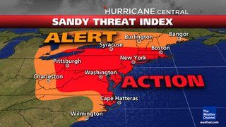
Het noordoosten van de Verenigde Staten bereidt zich voor op de komst van orkaan Sandy. Naar verwachting komt de orkaan maandag aan land, ergens tussen de steden Washington DC en Boston. Dat is het dichtst bevolkte deel van de VS; er wonen tientallen miljoenen mensen.
Autoriteiten in de staten die op het pad van de orkaan liggen, hebben evacuaties gelast van laag gelegen gebieden. In New York wordt gevreesd voor overstroming van het metrostelsel. Het stadsbestuur overweegt het ondergrondse vervoerssysteem te sluiten.
Maandag is het ook volle maan, dat betekent dat het hoogwater extreem is. Het waterpeil rond New York zal mogelijk ruim twee meter hoger zijn dan normaal.
Afgelast
President Obama heeft overleg gehad met zijn minister van Binnenlandse Zaken Napolitano over de voorbereidingen op de komst van de storm. Obama heeft campagnebijeenkomsten in Virginia en Colorado voor de komende dagen afgelast vanwege de orkaan.
Zijn rivaal voor het presidentschap, de Republikein Mitt Romney, gelastte al eerder campagnebijeenkomsten af. Over anderhalve week zijn er presidentsverkiezingen.
nos


101 kts = 187.05200 kilometersquote:
Voor Long Island heftig
[ Bericht 1% gewijzigd door #ANONIEM op 28-10-2012 08:12:17 ]


Dan ligt dus zowat heel NYC plat vanavond.quote:Governor Andrew M. Cuomo today announced that the Metropolitan Transportation Authority (MTA) will begin the orderly suspension of all subway, bus and commuter railroad service at 7 p.m. Sunday to protect customers, employees and equipment from the approach of Hurricane Sandy.
http://www.governor.ny.gov/press/10282012mtasuspension
Webcam @ Kill Devil Hills, NC: http://www.visitob.com/webcams/sea-ranch-kill-devil-hills/
Ziet er behoorlijk indrukwekkend uit.
Nog eentje iets noordelijker, Virgina Beach: http://www.vbbound.com/webcam/hampton-inn-virginia-beach/
[ Bericht 30% gewijzigd door YazooW op 28-10-2012 15:59:49 ]
Ziet er behoorlijk indrukwekkend uit.
Nog eentje iets noordelijker, Virgina Beach: http://www.vbbound.com/webcam/hampton-inn-virginia-beach/
[ Bericht 30% gewijzigd door YazooW op 28-10-2012 15:59:49 ]

quote:BULLETIN
HURRICANE SANDY ADVISORY NUMBER 25
NWS NATIONAL HURRICANE CENTER MIAMI FL AL182012
1100 AM EDT SUN OCT 28 2012
...SANDY EXPECTED TO BRING LIFE-THREATENING STORM SURGE FLOODING TO
THE MID-ATLANTIC COAST...INCLUDING LONG ISLAND SOUND AND NEW YORK
HARBOR...
...WINDS EXPECTED TO BE NEAR HURRICANE FORCE AT LANDFALL...
SUMMARY OF 1100 AM EDT...1500 UTC...INFORMATION
-----------------------------------------------
LOCATION...32.5N 72.6W
ABOUT 250 MI...400 KM SE OF CAPE HATTERAS NORTH CAROLINA
ABOUT 575 MI...930 KM S OF NEW YORK CITY
MAXIMUM SUSTAINED WINDS...75 MPH...120 KM/H
PRESENT MOVEMENT...NE OR 45 DEGREES AT 14 MPH...22 KM/H
MINIMUM CENTRAL PRESSURE...951 MB...28.08 INCHES
LOLquote:
Webcam @ Kill Devil Hills, NC: http://www.visitob.com/webcams/sea-ranch-kill-devil-hills/
Ziet er behoorlijk indrukwekkend uit.
Nog eentje iets noordelijker, Virgina Beach: http://www.vbbound.com/webcam/hampton-inn-virginia-beach/
Hier moest ik ff een plaatje van maken

Opgeblazen gevoel of winderigheid? Zo opgelost met Rennie!
Even volgen. Hopelijk valt de schade reuze mee.
Terrorism is the poor mans war, war is the rich mans terrorism.
Zone A in NYC gaat geëvacueerd worden meldt Bloomberg nu net op een persco.
Zone A: http://www.nyc.gov/html/o(...)cane_map_english.pdf
Live persco @ http://video.foxnews.com/(...)deo_id=1155606982001
Zone A: http://www.nyc.gov/html/o(...)cane_map_english.pdf
Live persco @ http://video.foxnews.com/(...)deo_id=1155606982001
wanneer verwachten ze nu dat de orkaan aankomt aan de kust?
“Loop niet voor me, want ik volg niet.
Loop niet achter me, want ik leid niet.
Loop gewoon naast me en wees mijn vriend.”
Loop niet achter me, want ik leid niet.
Loop gewoon naast me en wees mijn vriend.”
ik hoop voor de mensen daar, dat het net als vorig jaar, mee gaat vallen.quote:
Beter voor niets evacueren, dan slachtoffers
“Loop niet voor me, want ik volg niet.
Loop niet achter me, want ik leid niet.
Loop gewoon naast me en wees mijn vriend.”
Loop niet achter me, want ik leid niet.
Loop gewoon naast me en wees mijn vriend.”
Ik neem aan dat men vooral bezorgd is voor overtollig water? Want qua kracht is deze orkaan zelf maar een cat. 1... (van 5) of is ie intussen alweer sterker geworden?
Opgeblazen gevoel of winderigheid? Zo opgelost met Rennie!
Samenloop van omstandigheden, hoogtij bij landfall en een koufront vanuit het westen dat in aanraking met Sandy gaat komen.
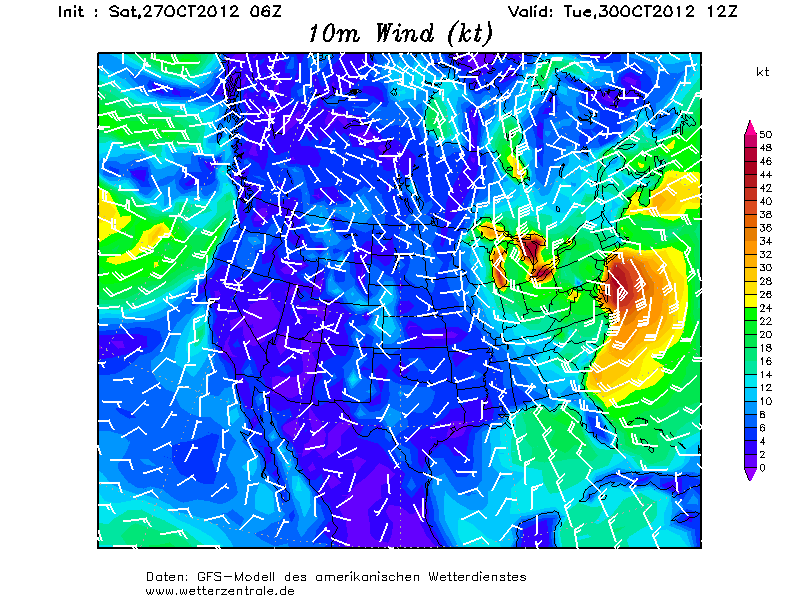
quote:Oct 27 (Reuters) - Hurricane Sandy is expected to hit the eastern United States with freakish power as it meets a cold front during a rare convergence of weather factors that is expected to steer the storm inland and widen the reach of its lashing winds.
Here is a look at some of the reasons why the event dubbed "Frankenstorm" by some weather watchers is so unusual and why it could be one of the most destructive U.S. storms in decades.
HISTORIC STORM
* Hurricane Sandy will join with a cold front in an event similar to Hurricane Hazel in 1954, said Bruce Sullivan, a meteorologist with the National Oceanic and Atmospheric Administration's Hydrometeorological Prediction Center. "We don't have a lot to compare it to in the last 50 years or so," he said.
* One factor that sets Hurricane Sandy apart from last year's Hurricane Irene, which caused $4.3 billion in damage, is that it will produce more than a foot (61 cm) of snow in higher elevations, especially in West Virginia, said Eric Leister, meteorologist with AccuWeather.com. That could lead to widespread power outages.
* Hurricane Sandy also presents more potential for flooding than Irene because it will produce more storm surges, particularly along northern New Jersey, New York City and Long Island, said meteorologist Dan Petersen with the Hydrometeorological Prediction Center.
* Meteorologists are reluctant to predict how destructive Sandy could be overall compared to past storms including Irene, but say it has the potential to be catastrophic. "This is a historic event, and if it turns out as bad as it could be, it's going to be likely one of those storms that people will be talking about 30, 40, 50 years from now," Leister said.
UNUSUAL PATH
* Most tropical storms that make landfall in the mid-Atlantic region move northeast and out toward the ocean. Sandy will move northwest and unleash its fury over a greater area of land than the average storm, Sullivan said.
* Sandy will be led inland on its destructive path by a high-pressure system over eastern Canada and a storm system moving southeast across the Tennessee Valley, Sullivan said. Those two systems and their winds will act like a "steering mechanism" and draw Sandy to the northwest, he said.
* This is late in the season for a hurricane to hit the northeastern United States, which could make Hurricane Sandy unusually destructive by allowing it to combine with colder air masses that are not normally present in the warmer summer months, Leister said.
VAST WIND FIELD
* Hurricane Sandy will generate heavy winds covering an area more than 500 miles (800 km) in diameter, Sullivan said. By comparison, the hugely destructive Hurricane Andrew in 1992 unleashed heavy winds over an area about one-fifth that size, he said.
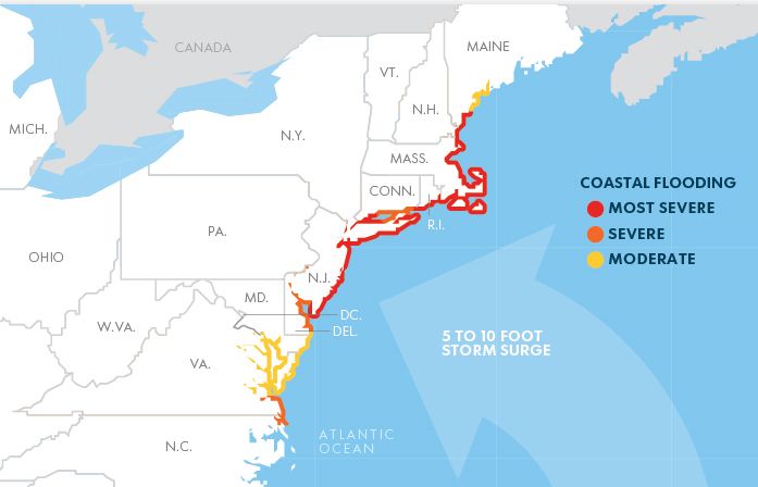
* The large wind storms generated by Hurricane Sandy will create major flooding and storm surges, said Chris Landsea, hurricane forecaster at the National Hurricane Center. Coastal areas will be inundated with up to 8 feet (2.4 meters) of storm surges, which will be devastating for low-lying areas, he said.

twitter:RyanMaue twitterde op zondag 28-10-2012 om 16:53:14 GFS 12z landfall central pressure is 936 mb (full-resolution surface field). Historically deep. reageer retweet
 GFS 12z landfall central pressure is 936 mb (full-resolution surface field). Historically deep.
 [ Bericht 98% gewijzigd door YazooW op 28-10-2012 17:17:52 ]
Burgemeester Michael Bloomberg van New York heeft zondag opdracht gegeven om 375.000 inwoners in laaggelegen gebieden te evacueren, wegens de naderende orkaan Sandy. „Dit is een zware en gevaarlijke storm”, zei Bloomberg vanmiddag.
OpperHeks van de vliegende bezemsteel te Amsterdam
5 is echt heel zeldzaam; er is er dit jaar maar eentje van kracht 3 geweest: Michael, voor een paar uur, midden op zee.quote:Op zondag 28 oktober 2012 16:39 schreef Eyjafjallajoekull het volgende:
Ik neem aan dat men vooral bezorgd is voor overtollig water? Want qua kracht is deze orkaan zelf maar een cat. 1... (van 5) of is ie intussen alweer sterker geworden?
Het is al behoorlijk zeldzaam dat een storm nog orkaankracht heeft als ie aan land komt; ook Sandy zal dat net wel/net niet hebben. Wat de storm kritiek maakt, is dat er veel laaggelegen land is, met een flinke kans op een vloed golf, en vooral: Er wonen gewoon heel veel mensen in dit gebied, die niet gewend zijn aan orkanen.
De storm is op zich niet heel heel zwaar, maar hij is wel bijzonder groot, en vooral bijzonder raar.

http://www.syfy.com/tinman/oz/
“The only thing standing between you and your goal is the bullshit story you keep telling yourself as to why you can't achieve it.”
“The only thing standing between you and your goal is the bullshit story you keep telling yourself as to why you can't achieve it.”
waarom deze tornado zo severe is zie Weer, Klimaat en Natuurrampenquote:
[..]
5 is echt heel zeldzaam; er is er dit jaar maar eentje van kracht 3 geweest: Michael, voor een paar uur, midden op zee.
Het is al behoorlijk zeldzaam dat een storm nog orkaankracht heeft als ie aan land komt; ook Sandy zal dat net wel/net niet hebben. Wat de storm kritiek maakt, is dat er veel laaggelegen land is, met een flinke kans op een vloed golf, en vooral: Er wonen gewoon heel veel mensen in dit gebied, die niet gewend zijn aan orkanen.
De storm is op zich niet heel heel zwaar, maar hij is wel bijzonder groot, en vooral bijzonder raar.
http://www.syfy.com/tinman/oz/
“The only thing standing between you and your goal is the bullshit story you keep telling yourself as to why you can't achieve it.”
“The only thing standing between you and your goal is the bullshit story you keep telling yourself as to why you can't achieve it.”
thanksquote:
http://www.mediaite.com/o(...)proaches-east-coast/
Livestreams.
Wat is dit saai, nou zolang er geen "The Day After Tomorrow"-achtige praktijken gebeuren hoeft dit topic niet eens open denk ik, haha.
Daarom staat het normaal ook altijd in het 'saaie' WKN... hoef je er niet tegen aan te kijkenquote:
Wat is dit saai, nou zolang er geen "The Day After Tomorrow"-achtige praktijken gebeuren hoeft dit topic niet eens open denk ik, haha.
Haha, was maar een grapje, maar kan je mij een korte uitleg geven waarom deze specifiek deze storm het waard is om in de gaten gehouden te worden. Hierboven lees ik wel wat maar ben niet zo thuis binnen dit vakgebied.quote:
[..]
Daarom staat het normaal ook altijd in het 'saaie' WKN... hoef je er niet tegen aan te kijken
Een orkaan in de buurt van NYC is sowieso gevaarlijk vanwege de lage ligging en hoge bevolkingsdichtheid. Het gebeurd dan ook zelden dat er een 'direct hit' komt zo hoog aan de Amerikaanse oostkust.quote:
[..]
Haha, was maar een grapje, maar kan je mij een korte uitleg geven waarom deze specifiek deze storm het waard is om in de gaten gehouden te worden. Hierboven lees ik wel wat maar ben niet zo thuis binnen dit vakgebied.
Filmpje uit post #19 geeft het goed weer wat er zou kunnen gebeuren.
Weliswaar klinkt een orkaan van 1e categorie voor ons 'zwak' maar zoiets hebben we hier dan ook nog nooit meegemaakt.
Vanuit het westen van de VS nadert een winterstorm die op 'Sandy' zal stuiten en ze zijn bang dat ze samensmelten tot een soort van "superstorm"...
Maar goed, het kan met een sisser aflopen.... doet het misschien ook wel, maar het kan ook een bende ellende veroorzaken.
Maar was er een paar maanden geleden niet ook al een orkaan op ramkoers met New York?quote:
[..]
Een orkaan in de buurt van NYC is sowieso gevaarlijk vanwege de lage ligging en hoge bevolkingsdichtheid. Het gebeurd dan ook zelden dat er een 'direct hit' komt zo hoog aan de Amerikaanse oostkust.
Filmpje uit post #19 geeft het goed weer wat er zou kunnen gebeuren.
Weliswaar klinkt een orkaan van 1e categorie voor ons 'zwak' maar zoiets hebben we hier dan ook nog nooit meegemaakt.
Vanuit het westen van de VS nadert een winterstorm die op 'Sandy' zal stuiten en ze zijn bang dat ze samensmelten tot een soort van "superstorm"...
Maar goed, het kan met een sisser aflopen.... doet het misschien ook wel, maar het kan ook een bende ellende veroorzaken.