WKN Weer, Klimaat en Natuurrampen
Lees alles over het onstuimige weer op onze planeet, volg orkanen en tornado's, zie hoe vulkanen uitbarsten en hoe Moeder Aarde beeft bij een aardbeving. Alles over de verwoestende kracht van onze planeet en tal van andere natuurverschijnselen.


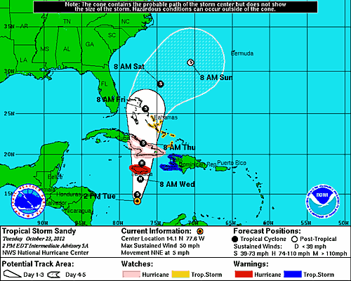
Vanochtend kreeg 99L dus alsnog de benaming "Sandy", de volgende naam in de rij van tropische stormen voor de Atlantische Oceaan. Jamaica krijgt woensdag/donderdag met Sandy te maken. Tegen die tijd kan Sandy zijn uitgegroeid tot orkaan. Daarna zal Cuba en de Florida Keys aan de beurt zijn.
Wat er daarna gebeurd is nog onzeker, maar gisteren schreef ik er al het volgende over:
Tropische Storm Sandy: Gevaar of geen gevaar?
Het Atlantische orkaanseizoen loopt op zijn einde en lijkt zich nog eens op te maken voor een flinke storm.
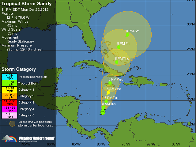
Op dit moment ligt er in de Caraïbische Zee een zogeheten "invest" van 90%. Dat wil zeggen dat de depressie 90% kans heeft om uit te groeien tot Tropische Storm. Vanochtend was dit nog 80%, gisteren 40%. De kans is dus groot dat vanavond of morgenochtend wordt besloten om dit gebied "Sandy" te gaan noemen.
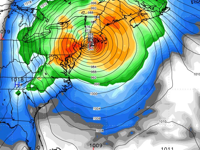
Het model van ECMWF en het Canadese model geven Sandy echter als potentieel gevaarlijke orkaan aan de Amerikaanse oostkust en wel in de regio van New York. De storm zou namelijk klem komen te zitten en aan de oostkust worden gehouden en kan zelfs uitgroeien tot orkaan en een verrassing voor de oostkust worden.
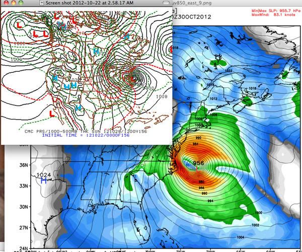
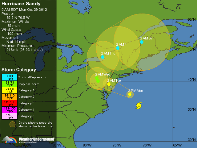
Modelprognose: 30 oktober, Sandy ligt voor de kust van de VS met een bizarre drukwaarde van 956
De algemeen bekende Joe Bastardi liet zich in tweets al uit over de komst van Sandy. Hierin gaf hij drie opties waarvan er één het scenario schetst die hij het omschrijft als een "once in a lifetime event for the US EastCoast, heavy snow for the mountains West". Het tweede mogelijke scenario is dat de storm zich wel degelijk ontwikkeld maar dan alsnog ontsnapt en afdraait. Optie drie is dat de storm zich helemaal niet ontwikkeld, maar dat lijkt de minst geloofwaardige optie. Bastardi zelf lijkt echter meer naar optie 1 te neigen. Hij vergelijkt het patroon en de ontwikkeling met Hurricane Hazel uit 1954.
Die storm eiste eerst 1000 levens op Haïti om vervolgens als joekel van een categorie 4 storm bij North/South Carolina aan land te gaan en vervolgens tot aan Canada door raasde en daar nog bijna 100 levens eiste.
De komende dagen zal blijken wat de ontwikkeling en koers van Sandy zal worden en of de storm inderdaad klem komt te zitten aan de oostkust. Het heeft er alle schijn van dat het Atlantische Orkaanseizoen nog een laatste verrassing in petto heeft...
LiveStreams
MediaITE
CNN

Live Reuters : Tracking Sandy
Webcams
The SandyCam
Stormchaser live webcam New Jersey
Atlantic City New Jersey Webcam
Statue of Liberty NY Webcam
North Carolina
Virginia Beach
New York Harbour
Webcams East Coast USA
Brooklyn Bridge Cam
LiveBlogs en overige
Live Blog weerman Raymond Klaassen
The Guardian: Live on Sandy
Crisismap 'Sandy' New York City
Stormsurge Maps
Interactive Stormsurge map NOAA
Zie ook
Hurricane Season 2012 # 1
[ Bericht 2% gewijzigd door Frutsel op 29-10-2012 13:48:06 ]

Sandy kan weer een orkaan worden die niet meer als naam gebruikt gaat worden. Net voor Jamaica orkaankracht. Veel landen gaan hier mee te maken krijgen.


Ziet er gevaarlijk uitquote:Op dinsdag 23 oktober 2012 21:09 schreef YazooW het volgende:
Die wilde ik net gaan posten
[ afbeelding ]

Of het wordt een schampschot ala Irenequote:
Precies tussen NYC en Boston, zou een behoorlijk puinhoop kunnen worden als dit gaat gebeuren.
Sandy..where are u going...
Depending on the path of Sandy, now brewing in the Caribbean, people along the East Coast during the week of Halloween could be looking a destructive storm or breathing a sigh of relief.
Final destination scenarios for Sandy range from bypassing the East Coast to creating a nightmare for tens of millions of people from Norfolk, Va., to Philadelphia, New York City and Boston.
Tropical Depression 18 formed in the central Caribbean during midday Monday and strengthened into Tropical Storm Sandy six hours later.
The AccuWeather.com Hurricane Center is confident that Sandy will head northward through Thursday, spreading life-threatening flooding rain across Jamaica, Hispaniola, eastern Cuba and the Bahamas.
Sandy is forecast to become a hurricane.
How Sandy tracks Friday and beyond is dependent on several weather factors, which at this time are very complex. These scenarios range from a disruptive and destructive hybrid between a hurricane and powerful nor'easter to a miss and a simple change to cooler weather for the East Coast.
The worst case scenario for the East Coast involves Sandy paralleling the coast from Florida to the Carolinas this weekend before being drawn inland over the mid-Atlantic or New England early next week.
While the Southeast coast would face heavy rain, strong winds and rough surf, far more serious impacts await communities from Virginia to Maine if this solution pans out.
Reminiscent of the "Perfect Storm" during the week of Halloween 1991, damaging winds and significant storm surge would unfold near and northeast of its center along the coast. Similar to the 1991 storm, these conditions could last for days.
In addition, if the storm were to move inland, unlike the storm in 1991, torrential rain would blast the I-95 corridor and heavy, wet snow would evolve over part of the Appalachian Mountains on the system's western and southwestern flank.
A powerful hybrid storm curving inland over the Northeast would bring major disruptions to travel, flooding, many downed trees and widespread power outages.
However, the above solution is far from set in stone.
There is equal possibility that the jet stream will sweep east fast enough to offer the East Coast protection from Sandy. A push of cooler air and spotty showers would be the result.
Bermuda may then become the storm's target.
Yet another solution would spare the East Coast of a direct hit but would still bring Sandy close enough to graze the coastline with several days of gusty winds and rough surf and seas.
The bottom line is that while uncertainty exists with Sandy's final destination, this is a storm that should be monitored closely by all residents from Florida to the Northeast.However, the above solution is far from set in stone.
There is equal possibility that the jet stream will sweep east fast enough to offer the East Coast protection from Sandy. A push of cooler air and spotty showers would be the result.
Bermuda may then become the storm's target.
Yet another solution would spare the East Coast of a direct hit but would still bring Sandy close enough to graze the coastline with several days of gusty winds and rough surf and seas.
The bottom line is that while uncertainty exists with Sandy's final destination, this is a storm that should be monitored closely by all residents from Florida to the Northeast.
Bron: Accuweather
Depending on the path of Sandy, now brewing in the Caribbean, people along the East Coast during the week of Halloween could be looking a destructive storm or breathing a sigh of relief.
Final destination scenarios for Sandy range from bypassing the East Coast to creating a nightmare for tens of millions of people from Norfolk, Va., to Philadelphia, New York City and Boston.
Tropical Depression 18 formed in the central Caribbean during midday Monday and strengthened into Tropical Storm Sandy six hours later.

The AccuWeather.com Hurricane Center is confident that Sandy will head northward through Thursday, spreading life-threatening flooding rain across Jamaica, Hispaniola, eastern Cuba and the Bahamas.
Sandy is forecast to become a hurricane.
How Sandy tracks Friday and beyond is dependent on several weather factors, which at this time are very complex. These scenarios range from a disruptive and destructive hybrid between a hurricane and powerful nor'easter to a miss and a simple change to cooler weather for the East Coast.
The worst case scenario for the East Coast involves Sandy paralleling the coast from Florida to the Carolinas this weekend before being drawn inland over the mid-Atlantic or New England early next week.
While the Southeast coast would face heavy rain, strong winds and rough surf, far more serious impacts await communities from Virginia to Maine if this solution pans out.
Reminiscent of the "Perfect Storm" during the week of Halloween 1991, damaging winds and significant storm surge would unfold near and northeast of its center along the coast. Similar to the 1991 storm, these conditions could last for days.
In addition, if the storm were to move inland, unlike the storm in 1991, torrential rain would blast the I-95 corridor and heavy, wet snow would evolve over part of the Appalachian Mountains on the system's western and southwestern flank.
A powerful hybrid storm curving inland over the Northeast would bring major disruptions to travel, flooding, many downed trees and widespread power outages.

However, the above solution is far from set in stone.
There is equal possibility that the jet stream will sweep east fast enough to offer the East Coast protection from Sandy. A push of cooler air and spotty showers would be the result.
Bermuda may then become the storm's target.
Yet another solution would spare the East Coast of a direct hit but would still bring Sandy close enough to graze the coastline with several days of gusty winds and rough surf and seas.
The bottom line is that while uncertainty exists with Sandy's final destination, this is a storm that should be monitored closely by all residents from Florida to the Northeast.However, the above solution is far from set in stone.
There is equal possibility that the jet stream will sweep east fast enough to offer the East Coast protection from Sandy. A push of cooler air and spotty showers would be the result.
Bermuda may then become the storm's target.
Yet another solution would spare the East Coast of a direct hit but would still bring Sandy close enough to graze the coastline with several days of gusty winds and rough surf and seas.
The bottom line is that while uncertainty exists with Sandy's final destination, this is a storm that should be monitored closely by all residents from Florida to the Northeast.
Bron: Accuweather
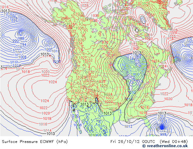
twitter:BigJoeBastardi twitterde op woensdag 24-10-2012 om 12:31:19 Even Brazilian model is joining ECMWF with Sandy hit on northeast coast.ECMWF as bad as it gets if correct144 http://t.co/I5qyrTDd reageer retweet
 Even Brazilian model is joining ECMWF with Sandy hit on northeast coast.ECMWF as bad as it gets if correct144
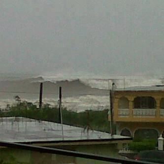
Sandy zit nu op 110 km/u (windkracht 11 Beaufort). De kern (986 mb) ligt op 190 km afstand van Kingston Jamaica.
Mogelijk tot 300 mm neerslag op Jamaica...Haiti...de Dominicaanse republiek en het oosten van Cuba.
Plaatselijk kan de hoeveelheid oplopen tot 500 mm.
Mogelijk tot 300 mm neerslag op Jamaica...Haiti...de Dominicaanse republiek en het oosten van Cuba.
Plaatselijk kan de hoeveelheid oplopen tot 500 mm.

Als de worst case scenarios uitkomen gaat dus een stuk van newyork onder water komen te staan.
Ik ben benieuwd.
Ik ben benieuwd.

Daar zijn al jaren bang voor... een Cat.1 Hurricane op NY kan dezelfde gevolgen hebben als een Katrina.quote:
Als de worst case scenarios uitkomen gaat dus een stuk van newyork onder water komen te staan.
Ik ben benieuwd.
Oh geweldig. Wil volgend jaar naar New York, als dat plat komt te liggen like New Orleans, kan ik dus beter even wachten met boeken...
Zonder wrijving geen glans
Vrijdag weten we pas meer denk iktwitter:Accu_Henry twitterde op woensdag 24-10-2012 om 13:19:18 Leaning toward the GFS now. That Sandy gets whipped out to sea and another storms forms off of NJ due to low NAO. reageer retweet
 Leaning toward the GFS now. That Sandy gets whipped out to sea and another storms forms off of NJ due to low NAO.
Sandy
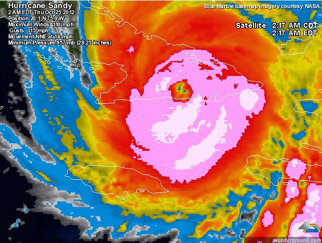
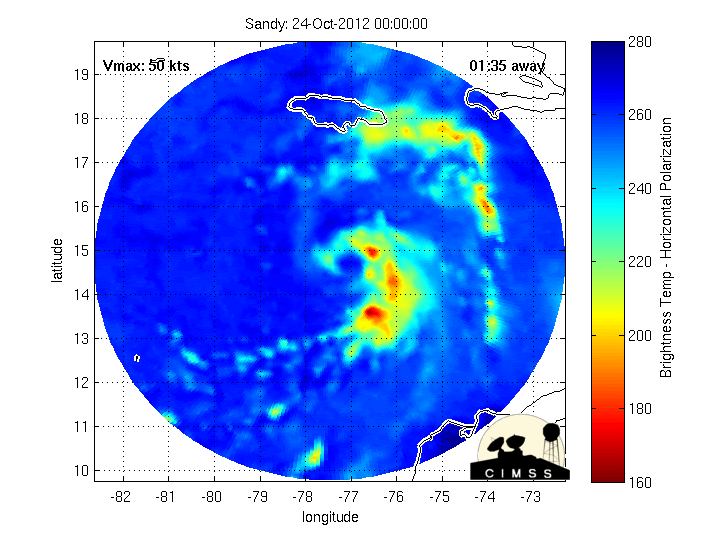
It is going to be a rough day in Jamaica as Sandy is nearing hurricane intensity this morning. Luckily, there is no eye readily apparent in satellite imagery which would indicate significant strengthening but I think it is only a matter of time before Sandy becomes the 10th hurricane of the season.
Jamaica will feel the effects today and tonight followed by a landfall in Cuba early tomorrow morning. The interaction with the higher terrain of eastern Cuba will disrupt the inner core of Sandy and should keep it from being too strong once in the Bahamas. However, sea surface temps are plenty warm there and it would not be surprising to see Sandy regain hurricane intensity while passing through the Bahamas.
Late tomorrow and in to Friday, Florida’s east coast will begin to feel the effects of Sandy wit an increase in wind and surf. Right now, the upper Keys and a good portion of SE Florida is under a tropical storm watch. Since the wind field of Sandy is forecast by the global models to expand significantly, I feel that it is almost a certainty that winds to at least tropical storm force, perhaps up to 50 mph, will be felt across portions of southeast Florida.
The other issue will be the huge wave set up that is going to happen as a result of Sandy’s massive wind field. Beach erosion is likely to be a major concern for east facing beaches along the Florida coast and working up the Southeast coast in to North Carolina. I cannot emphasize this enough and with the growing Moon phase towards full, we could be looking at a major coastal flood event for some areas of the Southeast U.S. coastline. A lot will depend on how far west Sandy tracks as some of the models are indicating a brief jog back to the northwest in a few days. Interests along the Florida east coast all the way up to the North Carolina Outer Banks should be paying close attention to this situation. The chance for substantial ocean overwash, especially in the Outer Banks, seems to be increasing with time.
Then we have the issue of the ECWMF’s idea of an unprecedented impact to the Northeast with Sandy or what ever it becomes once past about 35 N latitude. The model has not given up on its forecast of a general northward track, just passing the Outer Banks and then slamming the Northeast with what looks like hurricane conditions over a large area of coastline. While the GFS remains strong in its forecast of an out-to-sea track, it has been getting a little more west and north with each run. Even if the Euro forecast turns out to be dead wrong, Sandy will leave its mark down south along the Florida east coast and probably the North Carolina Outer Banks. If the Euro is right, then we will remember the ending of the 2012 hurricane season for many years to come.
(Bron: Hurricanetrack)
Deze maar weer even opgezocht...quote:
Als de worst case scenarios uitkomen gaat dus een stuk van newyork onder water komen te staan.
Ik ben benieuwd.


twitter:BigJoeBastardi twitterde op woensdag 24-10-2012 om 14:45:34 Its the PATTERN, not the models, that are the reason for the Sandy scenario. Major similarities, ie to 1954 capture of Hazel reageer retweet
twitter:BigJoeBastardi twitterde op woensdag 24-10-2012 om 14:47:12 I keep pounding away at this question .Why is Sandy going to turn TOWARD A RETREATING TROUGH rather than interact with the 1 coming at it reageer retweet
Hmm effe volgen 
Ritje daarheen lijkt me gaaf
Ritje daarheen lijkt me gaaf
Doe mee met het voorspellen van het weer!
Weekvoorspelling | Week 12 (invullen tot 16-03 - 11:59)
Maandvoorspelling Maart (Inzendingen gesloten)
Jaarvoorspelling 2025 / 2026
Weekvoorspelling | Week 12 (invullen tot 16-03 - 11:59)
Maandvoorspelling Maart (Inzendingen gesloten)
Jaarvoorspelling 2025 / 2026


Het oog begint langzaam aan zichtbaar te worden op de visible: http://www.ssd.noaa.gov/PS/TROP/floaters/18L/flash-vis-short.html
Livestream Jamaicaanse TV: http://www.televisionjamaica.com/LiveTV.aspx
Modellen trekken steeds verder naar het westen, zoals het er nu uit ziet gaat Sandy vlak langs de kust van Florida trekken.
Livestream Jamaicaanse TV: http://www.televisionjamaica.com/LiveTV.aspx
Modellen trekken steeds verder naar het westen, zoals het er nu uit ziet gaat Sandy vlak langs de kust van Florida trekken.


29 oktober is volle maan. Dan is het dus 31 oktober springtij. Extra hoog water dus.
GFS laat Sandy op de 31e aan land gaan. ECMWF iets eerder.
GFS laat Sandy op de 31e aan land gaan. ECMWF iets eerder.


Hmmm even een tvp aangezien ik nu op de Keys zit en morgen vertrek naar Miami 
Op dit moment al een windkracht vier hier, maar de radio heeft het over een mogelijke orkaan. Ik moet zaterdag vliegen, ik ben benieuwd
Op dit moment al een windkracht vier hier, maar de radio heeft het over een mogelijke orkaan. Ik moet zaterdag vliegen, ik ben benieuwd
The line is a dot to you!
Lijkt mee te vallen voor Floridaquote:. TROPICAL STORM WATCH REMAINS IN EFFECT...
... PROBABILITY OF TROPICAL STORM/HURRICANE CONDITIONS... THERE IS LITTLE CHANCE FOR HURRICANE CONDITIONS AT THIS TIME. ALSO... THE CHANCE FOR TROPICAL STORM CONDITIONS AT THIS TIME IS VERY SMALL. THIS REPRESENTS A GENERAL STEADY TREND SINCE THE LAST FORECAST.
The line is a dot to you!

ja het hostel ligt praktisch aan het strand dus dat komt goed.quote:http://i.fokzine.net/p/2s.gimgb]Op woensdag 24 oktober 2012 22:13 schreef aloa het volgende:[/b]
[..]
Denk ik ook. Kan nog wel hoge golven opleveren. Ik zou naar het strand gaan, als ik jouw was
Beetje jammer van die regen...
The line is a dot to you!
Foto's zijn welkomquote:Op woensdag 24 oktober 2012 22:26 schreef kepler het volgende:
[..]
ja het hostel ligt praktisch aan het strand dus dat komt goed.
Beetje jammer van die regen...


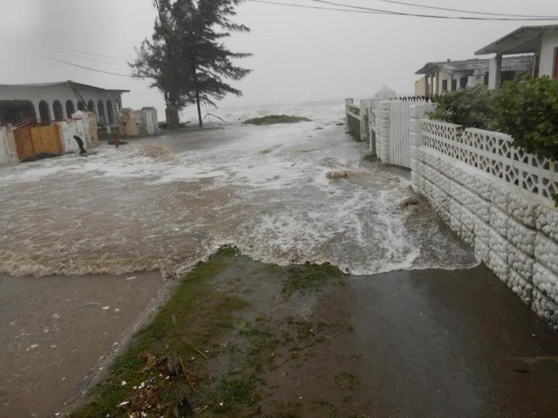
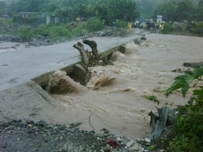
Dode Jamaica door orkaan Sandy
Op Jamaica is door de orkaan Sandy zeker één dode gevallen. Volgens de politie op het eiland werd de man bij een aardverschuiving bedolven onder stenen.
In grote delen van Jamaica is de elektriciteit uitgevallen. Bomen en elektriciteitsmasten zijn omgevallen en veel huizen staan onder water. 70 procent van het land zit zonder stroom.
In het zuiden van het eiland zwommen krokodillen door straten en tuinen van mensen. De krokodillen werden door de overstromingen meegesleurd uit de mangroven.
Cuba en Haïti
Sandy trekt nu richting Cuba en Haïti. Meteorologen verwachten dat de orkaan eerst in kracht afneemt, maar sterker wordt zodra die richting de Bahama's gaat. Mogelijk treft de orkaan later nog de Amerikaanse staat Florida.
NOS
[ Bericht 2% gewijzigd door #ANONIEM op 25-10-2012 08:30:33 ]