WKN Weer, Klimaat en Natuurrampen
Lees alles over het onstuimige weer op onze planeet, volg orkanen en tornado's, zie hoe vulkanen uitbarsten en hoe Moeder Aarde beeft bij een aardbeving. Alles over de verwoestende kracht van onze planeet en tal van andere natuurverschijnselen.


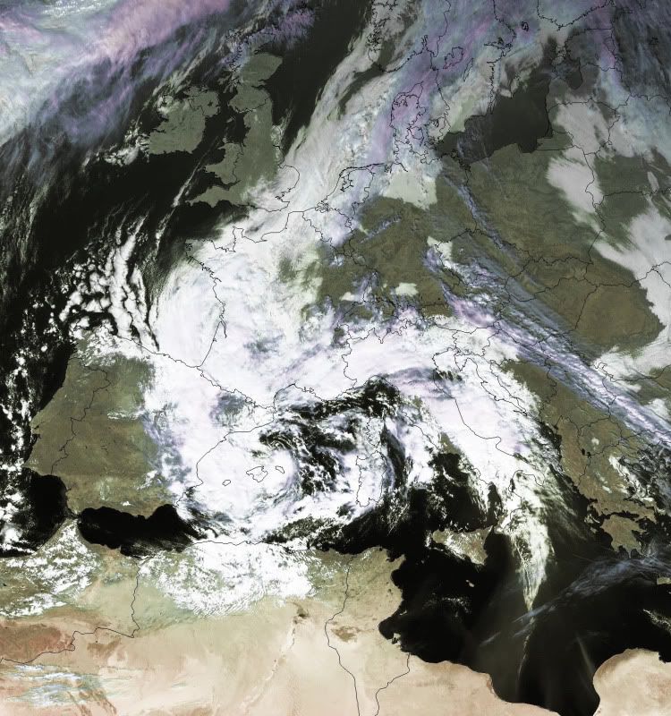
Tropische storm in de maak boven Middellands Zeegebied.
Afgelopen dagen heeft zich boven de Middellandse Zee een depressie geïnstalleerd die onder invloed van warme lucht uit Afrika steeds opnieuw aan kracht begon te winnen. De beelden uit Genua met eergisteren bijna 150l/m² op 1 dag zijn een gevolg van deze met warme lucht gevulde depressie. Het oosten van Spanje en het zuiden van Frankrijk worden ook al dagen geteisterd door enorm grote neerslaghoeveelheden en dat lijkt de komende uren niet anders te zijn, integendeel.
De laatste weermodellen laten een vreemd proces zien van deze depressie. Onder invloed van subtropisch lucht aan de oostelijke zijde van het systeem worden de windsnelheden opgedreven. WRF zinspeelt later vandaag en in de nacht op een 9 Beaufort aan de oostelijke kusten van Spanje. Samen met de in kracht aansterkende depressie kunnen we het hele systeem gaan catalogeren als een tropische depressie. Deze systemen zijn in Europa vrij zeldzaam, want meestal wordt een dergelijke depressie vrij snel afgezwakt tot een frontensysteem. De laatste tropische depressie in de Middellandse Zee dateert van 16 januari 1995.
© bericht: www.weatherservice.be (bij overname bericht= contact opnemen)
Bron kaartjes: Keruanos.org / Sat24
[ Bericht 0% gewijzigd door WeerServies op 06-11-2011 13:24:35 ]
Afgelopen dagen heeft zich boven de Middellandse Zee een depressie geïnstalleerd die onder invloed van warme lucht uit Afrika steeds opnieuw aan kracht begon te winnen. De beelden uit Genua met eergisteren bijna 150l/m² op 1 dag zijn een gevolg van deze met warme lucht gevulde depressie. Het oosten van Spanje en het zuiden van Frankrijk worden ook al dagen geteisterd door enorm grote neerslaghoeveelheden en dat lijkt de komende uren niet anders te zijn, integendeel.

De laatste weermodellen laten een vreemd proces zien van deze depressie. Onder invloed van subtropisch lucht aan de oostelijke zijde van het systeem worden de windsnelheden opgedreven. WRF zinspeelt later vandaag en in de nacht op een 9 Beaufort aan de oostelijke kusten van Spanje. Samen met de in kracht aansterkende depressie kunnen we het hele systeem gaan catalogeren als een tropische depressie. Deze systemen zijn in Europa vrij zeldzaam, want meestal wordt een dergelijke depressie vrij snel afgezwakt tot een frontensysteem. De laatste tropische depressie in de Middellandse Zee dateert van 16 januari 1995.

© bericht: www.weatherservice.be (bij overname bericht= contact opnemen)
Bron kaartjes: Keruanos.org / Sat24
[ Bericht 0% gewijzigd door WeerServies op 06-11-2011 13:24:35 ]
Fan van noodweer: http://www.weerstationwaregem.be

Zeker @ Forza. Ook als je bedenkt dat het al 16 jaar geleden is dat er zich een tropische storm in de Middellandse Zee kon ontwikkelen.
Fan van noodweer: http://www.weerstationwaregem.be
De hiel van de laars van Italie ligt om ramkoers? 
"We meet every day at the same cafe, six-thirty and no one knows she'll be there."

Neen @ Adelante. Dat is een sat24 beeld van 1995. Momenteel is de ontwikkeling van de depressie nog aan de gang ten westen van Corsica. 
Fan van noodweer: http://www.weerstationwaregem.be


Wat een grote onzin zeg, knap staaltje spammen met onjuistheden. Nee en TS heeft altijd de grootste praat over andere sites.... BAH Het is gewoon een afgesnoerd hoogte(laag).Dat wordt door het warme water gevoed. Niks bijzonders dus. We noemen dit ook wel een cut-off. Daarnaast vraag ik me af waar hij 150mm neerslag vandaan haalt terwijl er meer dan 400mm gevallen is bij Genua
Weer of geen weer, altijd actueel www.onweer-online.nl
Nieuwe beelden voor vanavond en vannacht, omvang is precies wel heel erg groot van het systeem.
Bron: lightningwizard.com
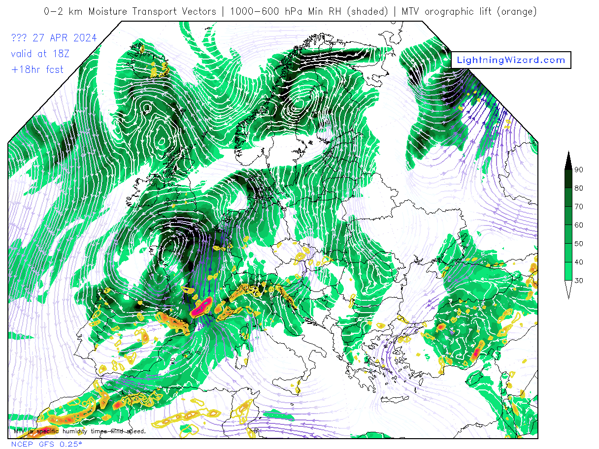
Bron: lightningwizard.com
Fan van noodweer: http://www.weerstationwaregem.be
Even meteoroloog van MeteoMedia gevraag, die zei het volgende:
quote:Precies, dit systeem is "geboren"(cut-off) vanuit de Atlantische hoogtetrog.
Daarnaast voldoet dit systeem ook niet aan de definities van tropische storingen(depressies) of cyclonen. Deze ontstaan in de ITCZ (intertropische convergentiezone) zone. Ook de warme kern ontbreekt.
Ciao Johann
Weer of geen weer, altijd actueel www.onweer-online.nl
Nou berg je weer en thee servies maar op!!!!!11!!
Weer of geen weer, altijd actueel www.onweer-online.nl
Of anders....??quote:Op zondag 6 november 2011 15:55 schreef meteo-online het volgende:
Nou berg je weer en thee servies maar op!!!!!11!!
Heeft het beestje al een naam?quote:
Gaat het kapot door de tropische storm
Life is Music
Nee, zal het ook niet gaan krijgen. Meteoroloog van Zwitserse media zit om deze tekst smakelijk te lachen. Zie post van mij waaromquote:
Weer of geen weer, altijd actueel www.onweer-online.nl
Ook op weerwoord zegt Henk L, die enorm veel kennis heeft hetvolgende:
Het systeem heeft nog altijd een relatief koude kern, een gewone extratropische depressie dus. Wel is er kans dat de kern langzaam gaat opwarmen de komende dagen, maar tegelijk stijgt de luchtdruk en zwakt de depressie af (zie link).
Het luchtdrukverval rondom de depressie is niet sterk. Alleen vlak voor de kust van Algerije melden enkele schepen windkracht 8 (de grens voor een tropische storm), maar over een groot gebied rond de depressie staat windkracht 4-6.
Hoewel er op de Middellandse Zee nu en dan systemen rondzwerven die lijken op tropische stormen (medicanes) met soms zelfs een fraai oog, is dit niet zo'n geval en lijkt het ook niet te gaan worden.
De luchtdruk op Memorca, het dichtst bij de kern, bedroeg 1000 hPa om 12Z.
http://moe.met.fsu.edu/cy(...)ive/11110606/20.html
EDIT: Duitse weerdienst in Offenbach heeft het de naam Rolf gegeven
Lees meer: Duitse weerdienst Offenbach heeft het Rolf genoemd
[ Bericht 7% gewijzigd door meteo-online op 06-11-2011 16:32:08 ]
Weer of geen weer, altijd actueel www.onweer-online.nl

Stukje weerwoord.....
NOS-teletekst meldt nog altijd "Boven de Middellandse Zee wordt vannacht een zware storm verwacht" en de website van Trouw zegt op gezag van het ANP: "De problemen zijn nog niet voorbij. Meteorologen waarschuwen voor een tropische storm boven de Middellandse Zee. De weermodellen voorspellen voor zondagavond en in de nacht van zondag op maandag windsnelheden boven de 100 kilometer per uur in vooral het zuiden van Frankrijk en het oosten van Spanje."
De feiten:
Momenteel staat er boven de westelijke Middellandse Zee hooguit windkracht 6. De luchtdruk is overal aan het oplopen; de kern van de depressie is nu zo'n 1005 hPa tegen 1000 hPa eerder vandaag.
Helaas is blijkbaar Weatherservice.be erin geslaagd een overdreven verhaal te laten doordringen in de pers. Ongetwijfeld is het aantal bezoekers van de site van die 'service' sterk gestegen. Namens alle meteorologen en serieuze weeramateurs, hartelijk dank voor dit stukje desinformatie
Weer of geen weer, altijd actueel www.onweer-online.nl

Dat heeft de Telegraaf weer zonder na te denken overgenomen.quote:
Stukje weerwoord.....
NOS-teletekst meldt nog altijd "Boven de Middellandse Zee wordt vannacht een zware storm verwacht" en de website van Trouw zegt op gezag van het ANP: "De problemen zijn nog niet voorbij. Meteorologen waarschuwen voor een tropische storm boven de Middellandse Zee. De weermodellen voorspellen voor zondagavond en in de nacht van zondag op maandag windsnelheden boven de 100 kilometer per uur in vooral het zuiden van Frankrijk en het oosten van Spanje."
De feiten:
Momenteel staat er boven de westelijke Middellandse Zee hooguit windkracht 6. De luchtdruk is overal aan het oplopen; de kern van de depressie is nu zo'n 1005 hPa tegen 1000 hPa eerder vandaag.
Helaas is blijkbaar Weatherservice.be erin geslaagd een overdreven verhaal te laten doordringen in de pers. Ongetwijfeld is het aantal bezoekers van de site van die 'service' sterk gestegen. Namens alle meteorologen en serieuze weeramateurs, hartelijk dank voor dit stukje desinformatie
Nieuwste sensationele kop in de Telegraaf: http://www.telegraaf.nl/b(...)_kouder__.html?p=1,1
De Telegraaf heeft gisteren alle informatie omtrent die depressie gekregen, helaas hebben ze er niets mee gedaan. Ook de zinnetjes van TS dat de Telegraaf het opgepikt heeft klopt niet. Maar goed, TS heeft altijd een grote mond dat hij geen sensatie verkoopt, maar dit is een heel mooi voorbeeld dat hij het wel doet. TS volgende keer eerst eens naar je eigen kijken alvorens je over andere gaat hebben. Door dit flutbericht, wat nergens op slaat, is de term meteorologie weer schade toegebracht.quote:Op maandag 7 november 2011 12:03 schreef aloa het volgende:
[..]
Dat heeft de Telegraaf weer zonder na te denken overgenomen.
Nieuwste sensationele kop in de Telegraaf: http://www.telegraaf.nl/b(...)_kouder__.html?p=1,1
Weer of geen weer, altijd actueel www.onweer-online.nl
Hij schijnt nu officieel "Invest 99L" te heten?
http://www.ssd.noaa.gov/PS/TROP/2011/bulletins/archive.html
07 Nov 2011 - INVEST - 1200 UTC
Leuke animatie hierro...
http://www.meteo-allerta.(...)-currents/italy.html
http://www.ssd.noaa.gov/PS/TROP/2011/bulletins/archive.html
07 Nov 2011 - INVEST - 1200 UTC
Leuke animatie hierro...
http://www.meteo-allerta.(...)-currents/italy.html
Een verstoring 
Citaat MC:
Op het westelijke deel van deel van de Middellandse Zee, waar nu een lagedrukgebied rondtolt, heersen watertemperaturen van globaal 21 of 22 graden. De combinatie hiervan en de nog koude bovenlucht is wellicht voldoende om nog wat te laten gebeuren. De verschillende computermodellen geloven er overigens niet in. Die laten vandaag en de komende nacht rond het laag nog een windkracht 7 tot 8 waaien, daarna neemt het geheel in activiteit af. Toch is de situatie interessant genoeg om het systeem in elk geval nog in de gaten te houden.
Heel artikel op: http://www.weer.nl/weer-i(...)iddellandse_zee.html
Weer of geen weer, altijd actueel www.onweer-online.nl
Komen die daar vaak voor? Als ik dat satelietshotje bekijk dan lijkt het wel op een kleine orkaan
Ze krijgen dus nog veel meer water aan de Cote D Azur

Ze krijgen dus nog veel meer water aan de Cote D Azur
Komt ieder jaar wel voor dat er een "verdacht" systeem is, zou me meer concentreren op IJslandquote:
Komen die daar vaak voor? Als ik dat satelietshotje bekijk dan lijkt het wel op een kleine orkaan
[ afbeelding ]
Ze krijgen dus nog veel meer water aan de Cote D Azur
Weer of geen weer, altijd actueel www.onweer-online.nl
Bron: Estofexquote:****** Tropical storm 01M/99L ******
SUMMARY: 8th NOV. 2011, 0600 UTC
-----------------------------------------------------------
LOCATION...41.5N 5.8E
ABOUT 108 NM...200 KM SE OF MARSEILLE
ABOUT 126 NM...233 KM W OF AJACCIO, CORSICA
MAXIMUM SUSTAINED WINDS...52 MPH...83 KM/H
PRESENT MOVEMENT...ROUGHLY 5KM/H TO THE EAST
MINIMUM CENTRAL PRESSURE... ROUGHLY 1000 hPa
UPDATE 06UTC: The center of the cyclone again became better organized with the strongest convection now in the southern and eastern part (maybe enhanced by the jet streak, which passes by to the SE). Some slow movement to the east occurred but despite a further consolidating cyclone, latest reports do not indicate any strengthening (also assisted by ASCAT data). No further surface reports were available.
NOTE 1: Despite issuing new ESTOFEX updates, this part of the outlook will be updated when new informations become available. Please check this table for further updates during the upcoming 24 hours.
NOTE 2: ESTOFEX is not responsible for forecasting any tropical storm activity. This is just an additional information and therefore captured as a "side-note". For more informations, please contact the following address of the Satellite Analysis Branch (http://www.ssd.noaa.gov/PS/TROP/2011/bulletins/archive.html,[SAB]).
As of 18 UTC (7th Nov.), the Satellite Analysis Branch upgraded the depression over the W-Mediterranean to "Tropical system 01M", as convection persisted for an adequate time atop the center. Since then, deep convection weakened somewhat with warming cloud tops next to the center. Nevertheless, very good banding is now present in all quadrants with good outflow atop (especially to the NE, pointing to a 30 m/s 300 hPa jet). A Dvorak number-pressure relation was used for the pressure classification (also at 21Z at the 7th, a ship at position N 41°36' , E 6°06' reported a pressure of 1005.0 mb with 38kt winds from 160°). The final wind strength reflects the intensity of the latest SAB guidance.
There remains some time left for further intensification, before geopotential heights slowly increase during the end of the forecast period. We would not be surprised to see another flare-up of DMC along the center due to the convective cycle of those features (peaking during the morning hours). The N-outflow may weaken somewhat as the upper jet to the north weakens, but at the same time the southern outflow channel could take profit of a 300 hPa streak, which crosses Sicily during the forecast from SW to NE. SSTs remain at or above 20°C, whereas 500 hPa temperatures gradually warm up 1-2K until 06Z. Combining all those effects, some further organization/strengthening is forecast if this system can support more convective bursts along the center before overall conditions become somewhat less favorable during the night hours onwards.
The storm motion is handeled badly by the models...without surprise. 01M is captured in a very weak steering flow and most models now show a system, which meanders around between the Balearic Islands and Corsica/Sardinia. In any case, residents along the adjacent coasts should keep a close eye on the further development of this feature as bands of strong convection may bring heavy downpours next to gusty winds.
A level 1 was issued not for the system itself (as we do not forecast tropical cyclone activity), but for the showers/thunderstorms, which accompany that cyclone. The level 1 covers heavy rainfall and strong to isolated severe wind gusts.
quote:Mediterranean storm: tempest in a teapot
A hybrid storm currently lashing the French Riviera with gusty winds, rough seas and rain is rare, but not unheard of for the Mediterranean Sea.
This particular storm seems to have been born out of a slow-moving, upper-level storm pestering the area from Spain and France to Italy since the middle of last week.
The parent storm funneled torrential rain into Genoa, Italy, last week, causing approximately half a dozen deaths and considerable destruction from flash flooding.
The storm near the French Rivera is forecast to break down over the next couple of days. However, heavy rain can lead to flash flooding, mudslides and landslides in the region. Locally gusty winds can reach near 50 mph along the coast. Seas may remain dangerous for bathers into the end of the week.
According to World Weather Expert Jim Andrews, "Although more like a polar storm, rather than a tropical storm, these 'tempests in a tea pot' seem to crop up, on average once every year."
The overall surface area of the Mediterranean is very small when compared to the Atlantic. Although relatively similar in size to the Gulf of Mexico and the Caribbean, it is longer and skinnier, making it tougher for tropical storm formation.
"The surface temperature of the Mediterranean Sea is much lower, on average, when compared to the Caribbean and the Gulf. It does approach minimal operating temperature for tropical storms during the late summer," Andrews said.
The surface of the Mediterranean Sea reaches about 80 degrees Fahrenheit during late August in some locations.
Interestingly, it seems the storms are more likely to form as Europe cools down in the fall and winter, when the water is warmest relative to the land. Hence, arguing against the suggestion of their tropical or even subtropical nature.
Perhaps Mediterranean storms of this caliber need a classification of their own.
One has to wonder how many storms of similar nature have foiled invasions on the shores of the Mediterranean over the centuries.
Karim Hamid (KMI) over de tropische storm in de Middellandse Zee. Vanaf 8:55 - 9:10 wordt het interessant.

Fan van noodweer: http://www.weerstationwaregem.be
|
|