WKN Weer, Klimaat en Natuurrampen
Lees alles over het onstuimige weer op onze planeet, volg orkanen en tornado's, zie hoe vulkanen uitbarsten en hoe Moeder Aarde beeft bij een aardbeving. Alles over de verwoestende kracht van onze planeet en tal van andere natuurverschijnselen.


Ik ben benieuwd wat mei nog gaat brengen.
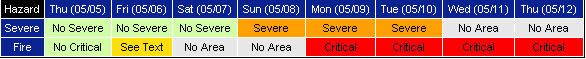
Zondag, maandag en dinsdag weer severe weather.
[ Bericht 4% gewijzigd door #ANONIEM op 05-05-2011 13:32:07 ]
Zondag, maandag en dinsdag weer severe weather.
[ Bericht 4% gewijzigd door #ANONIEM op 05-05-2011 13:32:07 ]

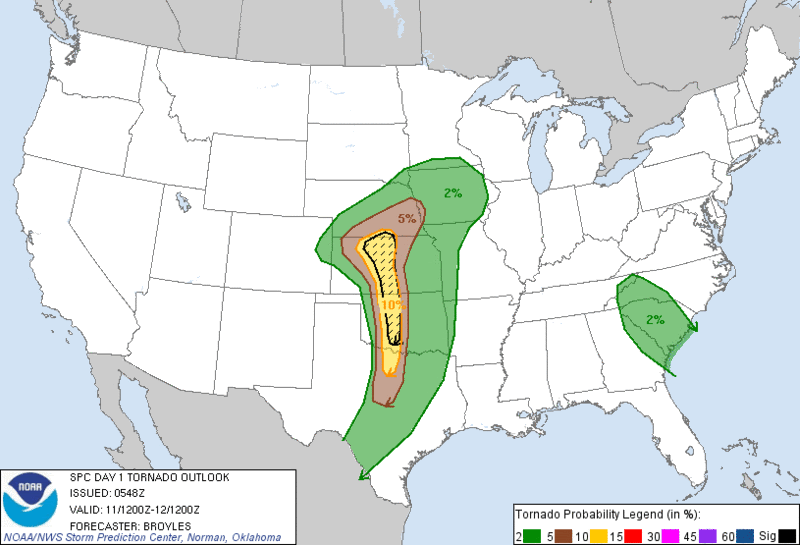
Men geeft niet aan waar het severe is of moet je via de site ergens op doorklikken?quote:Op donderdag 5 mei 2011 13:30 schreef aloa het volgende:
Ik ben benieuwd wat mei nog gaat brengen.
Zondag, maandag en dinsdag weer severe weather.
[ afbeelding ]
[ afbeelding ]
ff doorklikken inderdaadquote:Op donderdag 5 mei 2011 13:49 schreef Drassss het volgende:
[..]
Men geeft niet aan waar het severe is of moet je via de site ergens op doorklikken?
http://www.spc.noaa.gov/
Op de site zelf moet je deze hebben: http://www.news9.com/category/118569/weather-centerquote:
[..]
ff doorklikken inderdaad
http://www.spc.noaa.gov/
[ afbeelding ]
Daar staan forecasts en kaartjes.
be nice or go away
Humor, een kennis van me woont in Oklahoma en heeft tot nu toe nog alles gemist qua severe weather. Zegt hij eergister tegen me, let maar op als ik vertrek naar Nederland ( 10e ) dan krijgen we severe weather. Enja het komt nog uit ookquote:
[..]
ff doorklikken inderdaad
http://www.spc.noaa.gov/
[ afbeelding ]
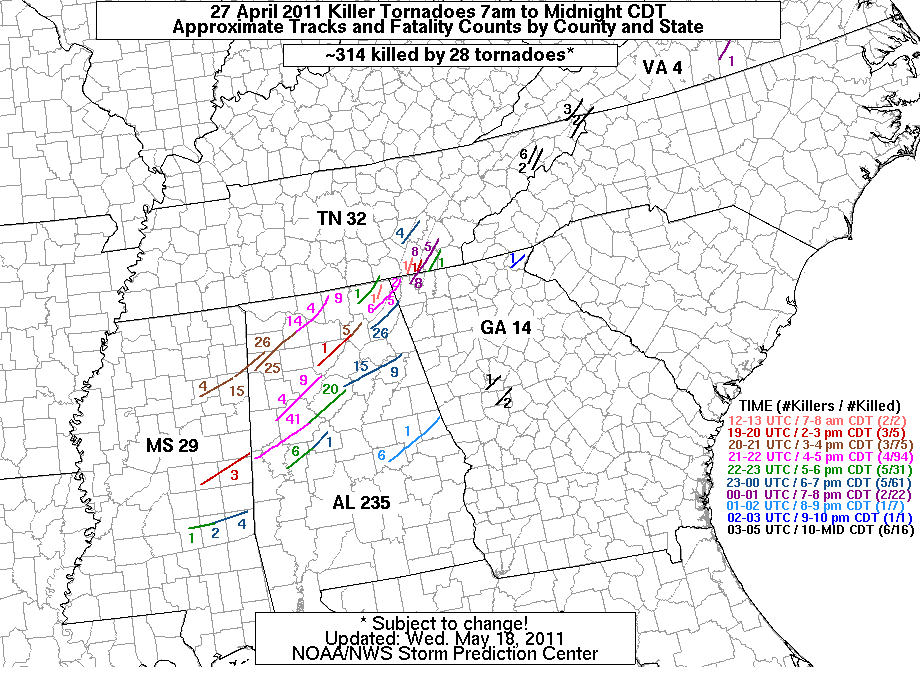
3 F5 Tornado's de 27e april.
quote:A third tornado from the April 27 Super Outbreak rated an EF-5
Yesterday, the Jackson, Mississippi office of the NWS upgraded the violent tornado that hit Neshoba, Kemper, Winston, and Noxubee Counties in the northeast part of the state to EF-5 status, with top winds of 205 mph. This tornado continued into Alabama and had a total path length of 92.3 miles. Three people died in the tornado, which was so powerful that it dug out the ground to a depth of two feet over an area 25 - 50 yards wide and several hundred yards long. This is the third tornado rated EF-5 from the April 27 outbreak; tornadoes that hit Smithville, MS and Hackleburg, AL also received EF-5 ratings.
Dus er komen nog een paar dagen met zwaar noodweer aan in de VS?
Dan hebben ze straks genoeg materiaal voor een heel lang seizoen Stormchasers op Discovery Channel.
Dan hebben ze straks genoeg materiaal voor een heel lang seizoen Stormchasers op Discovery Channel.
Oeh, dubbele afleveringen please!quote:
Dus er komen nog een paar dagen met zwaar noodweer aan in de VS?
Dan hebben ze straks genoeg materiaal voor een heel lang seizoen Stormchasers op Discovery Channel.
be nice or go away
Dit seizoen Stormchasers kan wel leuk worden denk ik  . Zover ik weet zijn ze ook niet gebonden aan een vast aantal afleveringen. Seizoen 3 had er 4/5, de laatste 8. Zou me niet verbazen als deze er een aantal meer krijgt

Recordpeil in Mississippi na tornado's
Omwonenden van de Amerikaanse rivier Mississippi zijn uit hun huizen gevlucht voor overstromingen. Het peil in de 3766 kilometer lange rivier breekt records die teruggaan tot 1927, meldde een woordvoerder van de National Weather Service. De oorzaak van de hoge waterstand zijn de fikse regenbuien die onlangs ontstonden bij de verwoestende tornado's.
Bewoners die nog bezig zijn de schade door de tornado's op te ruimen, leggen nu zandzakken voor hun huizen. De Nationale Garde en vrijwilligers zijn bezig provisorische dijken te bouwen.
Roeiboot
Bloemist Teresa Nance in Tennessee moest met een roeiboot naar haar kas om genoeg planten en bloemen te halen voor Moederdag. "Als God nu eens zijn pink zou gebruiken en dit water zou wegblazen, dan zouden we daar heel blij mee zijn", verzuchtte de bloemist uit Millington.
Texas kampt juist met uitzonderlijke droogte. (anp/sg)
hln
Er zijn ook weer genoeg chasers op de been.quote:
Vandaag 2 tot 5% kans op tornado's in oa Nebraska.
be nice or go away
Ergste overstromingen in jaren op komst in steden langs Mississippi
De inwoners van steden langs de Mississippi zijn verontrust door het immer stijgende peil van de rivier. Er wordt gewaarschuwd dat de ergste overstromingen in tientallen jaren op komst zijn. In Memphis (Tennessee), de thuisstad van wijlen Elvis Presley, zijn reeds meer dan duizend woningen ontruimd. Sommige lager gelegen gebieden liggen er al onder water.
De weerkundige dienst National Weather Service voorspelt dat de 'old man river' dinsdag in Memphis een piek zal bereiken van 14,6 meter, meer dan vier meter boven het kritieke niveau. Naar verwachting zal de langste rivier van de VS de volgende weken diverse steden stroomafwaarts blank zetten.
De ergste overstromingen tot dusver vonden plaats in het gebied rond de samenstroming van de Mississippi en de Ohiorivier, in de staten Illinois, Missouri en Kentucky. In sommige gebieden dreigt het waterpeil tot 19,5 meter te stijgen. De weersvoorspellers vrezen dat de overstromingen erger zullen zijn dan de beruchte 'floods' van 1927 en 1937. (afp/adv)
hln
jeetje, meer dan 1000 huizen, niet voor te stellen... Lijkt me best griezelig.quote:
Ergste overstromingen in jaren op komst in steden langs Mississippi
De inwoners van steden langs de Mississippi zijn verontrust door het immer stijgende peil van de rivier. Er wordt gewaarschuwd dat de ergste overstromingen in tientallen jaren op komst zijn. In Memphis (Tennessee), de thuisstad van wijlen Elvis Presley, zijn reeds meer dan duizend woningen ontruimd. Sommige lager gelegen gebieden liggen er al onder water.
De weerkundige dienst National Weather Service voorspelt dat de 'old man river' dinsdag in Memphis een piek zal bereiken van 14,6 meter, meer dan vier meter boven het kritieke niveau. Naar verwachting zal de langste rivier van de VS de volgende weken diverse steden stroomafwaarts blank zetten.
De ergste overstromingen tot dusver vonden plaats in het gebied rond de samenstroming van de Mississippi en de Ohiorivier, in de staten Illinois, Missouri en Kentucky. In sommige gebieden dreigt het waterpeil tot 19,5 meter te stijgen. De weersvoorspellers vrezen dat de overstromingen erger zullen zijn dan de beruchte 'floods' van 1927 en 1937. (afp/adv)
hln
be nice or go away
Memphis vreest voor overstromingen
(Novum/AP) - MEMPHIS - De Amerikaanse stad Memphis vreest voor overstromingen. Honderden mensen hebben het dringende advies gekregen hun huizen te verlaten, nu de waterstand van de rivier de Mississippi gevaarlijk dicht in de buurt komt van de 14,84 meter die in 1927 tot een overstromingsramp leidde die aan honderden mensen het leven kostte.
In enkele buitenwijken van Memphis staan al straten onder water. Daar zijn de afgelopen tijd al duizenden mensen geëvacueerd. De hoogste waterstand wordt dinsdag verwacht.
nieuws.nl

Das echt een flinke plas water...
hier ook nog een filmpje;
http://video.wetteronline(...)=1&pt=1&t=20110504fl
en een paar foto's;
http://www.wetteronline.d(...)t_am_Mississippi.htm
hier ook nog een filmpje;
http://video.wetteronline(...)=1&pt=1&t=20110504fl
en een paar foto's;
http://www.wetteronline.d(...)t_am_Mississippi.htm
Never Stop Exploring!
Life begins at the end of your comfort zone!
Follow me on Twitter: https://twitter.com/EdwinKr83 Instagram: https://www.instagram.com/edwinkr83/
Life begins at the end of your comfort zone!
Follow me on Twitter: https://twitter.com/EdwinKr83 Instagram: https://www.instagram.com/edwinkr83/
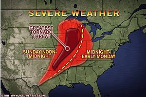
Violent Storms Aim for Heartland Wednesday, Thursday
While not the most intense outbreak of the spring in light of the tornadoes in the South recently, violent storms into Thursday will target part of tornado alley.
Powerful thunderstorms will target part of Tornado Alley into Thursday, but the most and the worst of the storms will tend to ride north and west of areas hit the hardest by tornadoes a couple of weeks ago.
Areas from Texas to Illinois and southern Wisconsin will be the primary focus of the storms with this severe weather outbreak that will include large hail, damaging straight-line wind gusts and a couple of handfuls of tornadoes.
Meteorologist Katie Storbeck described the nature of Tuesday's severe weather threat over the southern Plains in "Powerful Thunderstorms to Target Texas, Oklahoma."
Ms. Storbeck also describes the risk of severe weather in part of the Ohio Valley and the Appalachians Tuesday evening.
The violent storm threat zone will expand from Texas reaching southern Minnesota and southern Wisconsin by Wednesday evening.
The zone of severe thunderstorms will bow eastward as a storm system lifts northward across the Plains and dry air sweeps in from the west.
During Thursday, the zone of powerful thunderstorms will reach as far east as western Kentucky and northeastern Louisiana.
As Cory Mottice described in "Tornadoes Return Midweek," the storms will reach some areas currently being subjected to flooding.
During the past week or so, weather systems moving along through the Midwest have not had access to Gulf of Mexico moisture, which is a key ingredient for the nastiest of thunderstorms known as supercells.
These supercells are the main producers of tornadoes.
During the severe weather outbreak this week, the Gulf of Mexico will be open and will add in the necessary ingredient for the violent storms.
While AccuWeather.com meteorologists do not expect anything close to the number of tornadoes associated with the late-April outbreak, even one tornado hitting a populated area can lead to many casualties and widespread destruction.
This outbreak has the potential to produce a couple dozen or so tornadoes, a few of which could be strong, and should be taken seriously.
Accuweather
While not the most intense outbreak of the spring in light of the tornadoes in the South recently, violent storms into Thursday will target part of tornado alley.
Powerful thunderstorms will target part of Tornado Alley into Thursday, but the most and the worst of the storms will tend to ride north and west of areas hit the hardest by tornadoes a couple of weeks ago.
Areas from Texas to Illinois and southern Wisconsin will be the primary focus of the storms with this severe weather outbreak that will include large hail, damaging straight-line wind gusts and a couple of handfuls of tornadoes.
Meteorologist Katie Storbeck described the nature of Tuesday's severe weather threat over the southern Plains in "Powerful Thunderstorms to Target Texas, Oklahoma."
Ms. Storbeck also describes the risk of severe weather in part of the Ohio Valley and the Appalachians Tuesday evening.
The violent storm threat zone will expand from Texas reaching southern Minnesota and southern Wisconsin by Wednesday evening.

The zone of severe thunderstorms will bow eastward as a storm system lifts northward across the Plains and dry air sweeps in from the west.
During Thursday, the zone of powerful thunderstorms will reach as far east as western Kentucky and northeastern Louisiana.
As Cory Mottice described in "Tornadoes Return Midweek," the storms will reach some areas currently being subjected to flooding.

During the past week or so, weather systems moving along through the Midwest have not had access to Gulf of Mexico moisture, which is a key ingredient for the nastiest of thunderstorms known as supercells.
These supercells are the main producers of tornadoes.
During the severe weather outbreak this week, the Gulf of Mexico will be open and will add in the necessary ingredient for the violent storms.
While AccuWeather.com meteorologists do not expect anything close to the number of tornadoes associated with the late-April outbreak, even one tornado hitting a populated area can lead to many casualties and widespread destruction.
This outbreak has the potential to produce a couple dozen or so tornadoes, a few of which could be strong, and should be taken seriously.
Accuweather
2 tornadoreports en opvallend veel hagelreports (259) op 10 mei in de V.S.
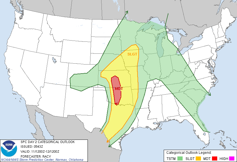
Vandaag een moderate risk.
Vandaag een moderate risk.
SPC heeft nu 328 doden 'geteld' op 27 april jl. Ik blijf het echt bizar vinden die dag...3 EF 5's ook gewoon.
's Avonds een man, overdags rustig an
quote:
Gaat ellendig worden in Oklahoma vandaag vrees ik... even blijven volgen.
Altijd de sarcasme modus aan
Hmm, ziet er niet mooi uit, wel grote kans op tornado's maar weer in bevolkte gebieden...
be nice or go away
da's altijd jammer. ik zie ze ook het liefst in onbewoond gebied, maarja, helaas kunnen we ze niet sturenquote:
Hmm, ziet er niet mooi uit, wel grote kans op tornado's maar weer in bevolkte gebieden...
Altijd de sarcasme modus aan
Nee, idd, ik hoop niet dat het weer zo'n bizarre nacht wordt...quote:
[..]
da's altijd jammer. ik zie ze ook het liefst in onbewoond gebied, maarja, helaas kunnen we ze niet sturen
be nice or go away
ze krijgen het wel voor hun kiezen daar, tornado op tornado en ook die overstromingen, erg hoor. Hier worden meteen op alle TV zenders grote nationale inzamelingsakties gehouden, krijg het idee dat de mensen het daar zelf maar moeten uitzoekenquote:
[..]
Nee, idd, ik hoop niet dat het weer zo'n bizarre nacht wordt...
Altijd de sarcasme modus aan
Dat klopt idd, kijk maar eens naar Katrina, er zijn in New-Orleans nog mensen die hun huis nog niet weer op orde hebben.quote:
[..]
ze krijgen het wel voor hun kiezen daar, tornado op tornado en ook die overstromingen, erg hoor. Hier worden meteen op alle TV zenders grote nationale inzamelingsakties gehouden, krijg het idee dat de mensen het daar zelf maar moeten uitzoeken
be nice or go away
Ah, dankjewelquote:
Heb dit linkje nog niet voorbij zien komen
http://www.boston.com/big(...)_river_flooding.html
be nice or go away
Tornadojacht weer van start
In het Amerikaanse ‘Tornado Alley’ komen de zwaarste onweersbuien voor die zich op aarde voordoen. Deze buien zijn in staat om veel bliksem, regen, grote hagelstenen, zeer zware windstoten en tornado’s te produceren. Aan de ene kant zaait dit onheil soms dood en verderf in Amerika. Maar aan de andere kant kan het (in onbewoond gebied) ook een prachtig natuurfenomeen zijn. Reden voor sommige mensen om erheen te reizen.
Dat de tornadojagers niet alleen uit Amerika komen, blijkt wel uit het feit dat sinds 1996 bijna ieder jaar een team met meteorologen van Meteo Consult naar Amerika is gegaan. Ook dit jaar gaan de mannen van Tornadojagers.nl (voorheen DutchTex en DutchTrex) weer die kant op. Aanstaande maandag (16 mei) vliegen ze van Schiphol naar Dallas (Texas) voor bijna 3 weken ‘jacht’.
Explosief weer in Tornado Alley door geografische omstandigheden
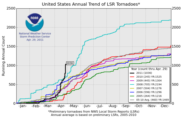
In Amerika is alles groter dan bij ons het geval is. De auto’s, vrachtwagens, hamburgermenu’s en… het weer. Tornado’s zijn in Nederland immers eerder uitzondering dan regel. In de Verenigde Staten is dat precies andersom. Mede door enkele tornado-outbreaks in april, staat de teller dit jaar inmiddels op ruim 1000. Daarmee is 2011 nu al een uniek recordjaar wat tornado’s betreft.
Dit gevaarlijke weer in Amerika wordt veroorzaakt door de geografische omstandigheden. Belangrijkste is de Golf van Mexico. Warme en vochtige lucht uit deze zee stroomt met een zuidelijke wind Tornado Alley binnen en is de belangrijkste voedingsbron voor de onweersbuien en tornado’s. Eenmaal op land komt de lucht in botsing met droge lucht uit de Rocky Mountains en koude lucht uit het noorden.
Windschering is noodzakelijk
Dit alleen blijkt al een explosief mengel te zijn en is voldoende voor de vorming van onweersbuien. Maar voor zware buien (ook wel supercells genoemd) en met name tornado’s is meer nodig: windschering. Hiermee bedoelen we dat de windrichting en –snelheid op de grond anders zijn dan op grotere hoogte in de atmosfeer.
Zonder windschering wordt de opwaartse luchtstroom in een bui na verloop van tijd verslagen door de neerwaartse luchtbewegingen. Hierdoor sterft de bui al snel uit. Door windschering wordt de opwaartse luchtstoom iets gekanteld. Het gevolg is dat de bui zichzelf veel en veel langer in stand kan houden omdat de daalstroming op een andere plaats (en dus niet in de weg) ligt. Tot slot veroorzaakt windschering enige rotatie in de onweersbui, wat nodig is voor de vorming van tornado’s.
2010 was een groot succes voor de Nederlandse tornadojagers
Tijdens de tornadojacht van 2010 hadden de tornadojagers veel geluk. Met in totaal 18 tornado’s was dit misschien wel de succesvolste tornadojacht ooit. Het meest bijzondere was de F4 tornado die op zaterdag 22 mei in Bowdle (South Dakota) werd gezien. Deze tornado bewoog zo traag dat het veilig was om hem tot op enkele honderden meters te laten naderen. De Discovery serie Stormchasers besloot er een hele aflevering aan te wijden, waarin de tornado ‘The perfect storm’ werd genoemd. Een eigen filmpje van die tornado staat hieronder.
De kans dat dit jaar net zo succesvol wordt, is natuurlijk klein. Dat beseffen de tornadojagers zich maar al te goed. Zeker gezien het feit dat er ook jaren zijn waarin je helemaal geen tornado ziet. Je moet immers een beetje geluk hebben en op het goede tijdstip op de juiste plaats staan. Een minuut te laat of een halve kilometer verderop kan al betekenen dat je een tornado niet ziet. Daarbij ben je mede afhankelijk van bijvoorbeeld het wegennet, dat niet altijd meewerkt.
Volg de Nederlandse tornadojagers
Het team van 2011 bestaat uit Arno Paanstra, Ben Peters, Floris Bijlsma en Wouter de Baar. Zij vertrekken op maandag 16 mei en zetten op zondag 5 juni weer voet op Nederlandse bodem. Via de site http://www.tornadojagers.nl kunt u hun belevenissen volgen. Er wordt geprobeerd hier dagelijks een verslag op te zetten. Ook is het (waarschijnlijk) mogelijk om met de GPS-tracker te kijken waar zij zich bevinden. Hierbij wordt geprobeerd om iedere minuut een foto te uploaden met de webcam in de bus. Tot slot kunt u de tornadojagers ook volgen via Twitter (@Tornadojagers) of Facebook.
weer.nl
In het Amerikaanse ‘Tornado Alley’ komen de zwaarste onweersbuien voor die zich op aarde voordoen. Deze buien zijn in staat om veel bliksem, regen, grote hagelstenen, zeer zware windstoten en tornado’s te produceren. Aan de ene kant zaait dit onheil soms dood en verderf in Amerika. Maar aan de andere kant kan het (in onbewoond gebied) ook een prachtig natuurfenomeen zijn. Reden voor sommige mensen om erheen te reizen.
Dat de tornadojagers niet alleen uit Amerika komen, blijkt wel uit het feit dat sinds 1996 bijna ieder jaar een team met meteorologen van Meteo Consult naar Amerika is gegaan. Ook dit jaar gaan de mannen van Tornadojagers.nl (voorheen DutchTex en DutchTrex) weer die kant op. Aanstaande maandag (16 mei) vliegen ze van Schiphol naar Dallas (Texas) voor bijna 3 weken ‘jacht’.
Explosief weer in Tornado Alley door geografische omstandigheden
In Amerika is alles groter dan bij ons het geval is. De auto’s, vrachtwagens, hamburgermenu’s en… het weer. Tornado’s zijn in Nederland immers eerder uitzondering dan regel. In de Verenigde Staten is dat precies andersom. Mede door enkele tornado-outbreaks in april, staat de teller dit jaar inmiddels op ruim 1000. Daarmee is 2011 nu al een uniek recordjaar wat tornado’s betreft.
Dit gevaarlijke weer in Amerika wordt veroorzaakt door de geografische omstandigheden. Belangrijkste is de Golf van Mexico. Warme en vochtige lucht uit deze zee stroomt met een zuidelijke wind Tornado Alley binnen en is de belangrijkste voedingsbron voor de onweersbuien en tornado’s. Eenmaal op land komt de lucht in botsing met droge lucht uit de Rocky Mountains en koude lucht uit het noorden.
Windschering is noodzakelijk
Dit alleen blijkt al een explosief mengel te zijn en is voldoende voor de vorming van onweersbuien. Maar voor zware buien (ook wel supercells genoemd) en met name tornado’s is meer nodig: windschering. Hiermee bedoelen we dat de windrichting en –snelheid op de grond anders zijn dan op grotere hoogte in de atmosfeer.
Zonder windschering wordt de opwaartse luchtstroom in een bui na verloop van tijd verslagen door de neerwaartse luchtbewegingen. Hierdoor sterft de bui al snel uit. Door windschering wordt de opwaartse luchtstoom iets gekanteld. Het gevolg is dat de bui zichzelf veel en veel langer in stand kan houden omdat de daalstroming op een andere plaats (en dus niet in de weg) ligt. Tot slot veroorzaakt windschering enige rotatie in de onweersbui, wat nodig is voor de vorming van tornado’s.
2010 was een groot succes voor de Nederlandse tornadojagers
Tijdens de tornadojacht van 2010 hadden de tornadojagers veel geluk. Met in totaal 18 tornado’s was dit misschien wel de succesvolste tornadojacht ooit. Het meest bijzondere was de F4 tornado die op zaterdag 22 mei in Bowdle (South Dakota) werd gezien. Deze tornado bewoog zo traag dat het veilig was om hem tot op enkele honderden meters te laten naderen. De Discovery serie Stormchasers besloot er een hele aflevering aan te wijden, waarin de tornado ‘The perfect storm’ werd genoemd. Een eigen filmpje van die tornado staat hieronder.

De kans dat dit jaar net zo succesvol wordt, is natuurlijk klein. Dat beseffen de tornadojagers zich maar al te goed. Zeker gezien het feit dat er ook jaren zijn waarin je helemaal geen tornado ziet. Je moet immers een beetje geluk hebben en op het goede tijdstip op de juiste plaats staan. Een minuut te laat of een halve kilometer verderop kan al betekenen dat je een tornado niet ziet. Daarbij ben je mede afhankelijk van bijvoorbeeld het wegennet, dat niet altijd meewerkt.
Volg de Nederlandse tornadojagers
Het team van 2011 bestaat uit Arno Paanstra, Ben Peters, Floris Bijlsma en Wouter de Baar. Zij vertrekken op maandag 16 mei en zetten op zondag 5 juni weer voet op Nederlandse bodem. Via de site http://www.tornadojagers.nl kunt u hun belevenissen volgen. Er wordt geprobeerd hier dagelijks een verslag op te zetten. Ook is het (waarschijnlijk) mogelijk om met de GPS-tracker te kijken waar zij zich bevinden. Hierbij wordt geprobeerd om iedere minuut een foto te uploaden met de webcam in de bus. Tot slot kunt u de tornadojagers ook volgen via Twitter (@Tornadojagers) of Facebook.
weer.nl
Spuisluizen geopend om New Orleans te redden van Mississippi
Het Amerikaanse leger is zaterdag begonnen met het openen van de spuisluizen in een rivierdijk van de overvolle Mississippi. Tot 7.770 vierkante kilometer land wordt onder water gezet om de steden New Orleans en Baton Rouge te ontzien.
De sluizen worden langzaam opengezet om te voorkomen dat de geëvacueerde huizen worden getroffen door een soort vloedgolf. Het overstromingsgebied moet een soort omleiding naar de Golf van Mexico vormen zodat het water bij de twee grootste steden van Louisiana minder hoog stijgt.
Zodra alle 125 sluizen open staan, kan het water tot zes meter hoog gaan staan in het overstromingsgebied. Het is voor het eerst sinds 1973 dat wordt gekozen voor deze noodoplossing. De regio heeft te kampen met de ergste overstromingen in meer dan zeventig jaar. Het Rode Kruis heeft voorzieningen getroffen om duizenden mensen op te vangen.
De operatie kan de woningen van 25.000 mensen en 11.000 gebouwen raken. De autoriteiten hebben de mensen in het overstromingsgebied voor hun offer gedankt. Sommigen van hen zeggen boos te zijn, anderen bang, (anp/tma)
hln
Wat een ellende, geen idee waarom ze geen informatie vragen aan Nederland, ze zitten daar maar te klooien en hier weet men misschien wel een oplossing.
be nice or go away
Huizen ondergelopen door Mississippi
In de Amerikaanse staat Louisiana zagen dorpsbewoners zondag wanhopig hoe het overvloedige water van de Mississippi hun huizen overspoelde.
Het water was naar hun regio afgeleid voor gecontroleerde overstromingen. Dat moet de steden New Orleans en Baton Rouge behoeden voor schade door het hoge waterpeil.
''Wat geeft hen het recht om ons onder water te zetten?'', verzuchtte Cindy Prejean uit Gibson. ''Ik begrijp het, maar hier zijn zoveel dorpen, zoveel boeren en zoveel bedrijven. Laat iedereen voor ons bidden.''
''Het lijkt wel een slagveld'', zei Ronald Perry, een bewoner van het dorpje Butte LaRose. ''Dit hadden we nooit verwacht. We leefden hier rustig als gepensioneerden en alles is nu op zijn kop gezet.''
Sluizen
Het Amerikaanse leger heeft zondag totaal vier sluizen opengezet van een dam in de Morganza Spillway. Het is de eerste keer sinds 1973 en slechts de tweede maal in het zestigjarig bestaan van de dam. De komende dagen gaan nog meer sluizen open.
Totaal zal naar schatting 1,2 miljoen hectare onderlopen. Zo'n 25.000 bewoners worden getroffen. Op sommige plaatsen komt het water vele meters hoog te staan.
''Wij in Louisiana zijn vechters'', zei Guy Cormier, voorzitter van de St. Martin's parochie die onder water komt te staan. ''Mijn opa vocht tegen de overstroming van 1927, mijn vader hielp bij de overstroming in 1973. Hier sta ik in 2011 om het water te bevechten.''
Opoffering
Burgemeester Mitch Landrieu van de stad New Orleans zei dat hij zich bewust was van de enorme opoffering van de bewoners van omliggende dorpen.
''We geloven dat de stad New Orleans veilig blijft'', zei hij, maar hij voegde er aan toe: ''Dit is een erg tragische situatie, echt waar. Ons hart gaat uit naar de bewoners in de getroffen gebieden .We voelen ons niet prettig dat anderen schade lijden om New Orleans te beschermen.''
Sneeuw
De overstromingen zijn het gevolg van zware regenbuien vorige maand en van smeltende sneeuw. Het waterpeil breekt op sommige plaatsen records uit 1927 van de Mississippi, de op twee na langste rivier in Noord-Amerika.
Het water heeft al duizenden woningen, boerderijen en wegen ondergespoeld in andere Amerikaanse staten zoals Illinois, Missouri, Kentucky, Tennessee, Arkansas en Mississippi.
nu.nl
"Severe weather to threaten the southern Plains both Wednesday and Thursday"

quote:After quiet weather on Monday, the danger of potentially damaging thunderstorms and tornadoes will return to the southern Plains at midweek.
Widespread severe weather will wait until the arrival of a potent Pacific storm before igniting across the southern Plains.
This system must first deliver another shot of rain to California Monday into Tuesday, according to AccuWeather.com Senior Meteorologist Jim Andrews.
The storm will only crawl out of the Rockies at midweek, causing severe weather to threaten the southern Plains both Wednesday and Thursday.
The danger will linger into Friday if the storm is even slower to emerge onto the Plains than currently expected. The storm will have difficulty making rapid eastward progress due to the stubborn Northeast rainmaker.
The strongest thunderstorms on Wednesday are expected late in the day from southwestern Kansas to central Texas.
The severe weather threat will then only shift slightly to the east across the southern Plains on Thursday. It is also possible that this zone expands northward into Nebraska.
Thursday will likely yield more severe thunderstorms than Wednesday. If the slower solution discussed above pans out, Friday would become the most active day of this week for severe weather across the southern Plains.
Cities at risk for powerful thunderstorms Wednesday and/or Thursday include Dodge City and Wichita, Kan., Oklahoma City, and Abilene, Wichita Falls and Dallas, Texas.
Damaging winds, large hail, frequent lightning and tornadoes are all dangers associated with the impending severe thunderstorms.
Violent thunderstorms may actually return to the southern Plains late Tuesday afternoon, but would be extremely spottier in nature and confined to the Texas Panhandle.
Rain, let alone severe weather, will be completely absent from the southern Plains on Monday. A cool dome of high pressure will instead be in control.
All residents across the southern Plains should continue to check back with AccuWeather.com for updates on this impending severe weather event.
Het is wel rustig momenteel zeg...
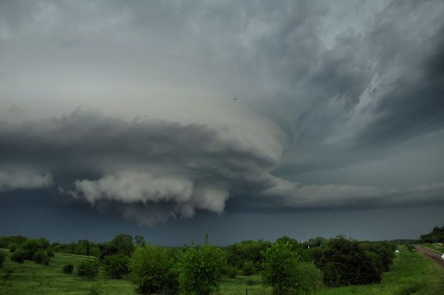
Interessante afbeelding van 27 april:
Interessante afbeelding van 27 april:
's Avonds een man, overdags rustig an
Een aantal beginnende onweerscellen in Oklahoma inderdaad. Eens kijken of het nog meer gaat ontwikkelen.quote:
zo, veel aan de hand momenteel, enorm veel chasers op de been
ben ook benieuwd. Mocht je een weerzender vinden die uitzendt, dan zou ik erg blij zijn met een linkjequote:
[..]
Een aantal beginnende onweerscellen in Oklahoma inderdaad. Eens kijken of het nog meer gaat ontwikkelen.
Altijd de sarcasme modus aan
Geen probleem ik geef wel een gil. Die 2 in Oklahoma zijn meteen online als de eerste tornado reports binnen komen, ik hou ze wel even in de gaten.quote:
[..]
ben ook benieuwd. Mocht je een weerzender vinden die uitzendt, dan zou ik erg blij zijn met een linkje
Ik denk wel dat de meeste spektakel in Kansas zal zijn vandaag ( moderate risk gebied ).
ik ga voorlopig toch nog niet slapen. Had die 2 in Oklahoma al geprobeerd maar zenden nog niet uit.quote:
[..]
Geen probleem ik geef wel een gil. Die 2 in Oklahoma zijn meteen online als de eerste tornado reports binnen komen, ik hou ze wel even in de gaten.
Ik denk wel dat de meeste spektakel in Kansas zal zijn vandaag ( moderate risk gebied ).
Altijd de sarcasme modus aan
Ik ben ook nog wel wakker. Ik zal even kijken of Kansas al iets online heeft..quote:
[..]
ik ga voorlopig toch nog niet slapen. Had die 2 in Oklahoma al geprobeerd maar zenden nog niet uit.

Alsof het weekend is, zoveel zijn er nu online ja.quote:
de chasers twitteren er op los momenteel
[ afbeelding ]
hebben allemaal wat eerder weekend genomen denk ik. Zou die file daar wel eens live willen zien. Er schijnt trouwens ook een Nederlands chase team te zijn nu, streamen alleen nietquote:
[..]
Alsof het weekend is, zoveel zijn er nu online ja.
Altijd de sarcasme modus aan
Moet er morgen toch weer vroeg uit dus ik ga je niet zo lang meer verzegelenquote:
ik heb het in de gaten, ach, wacht nog wel een tijdje af
Edit: Tornado warning voor de cell NO van Altus Oklahoma.
Vandaag reist er ook een Nederlander af naar Tornado Alley, hij gaat daar chasen met Cloud9 tours. Mocht hij tijd hebben dan schrijft hij op zijn blog updates. Mensen die interesse hebben kunnen het lezen op zijn site:
http://www.supercell.nl/blogs/index.php?blog=5
http://www.supercell.nl/blogs/index.php?blog=5
Weer of geen weer, altijd actueel www.onweer-online.nl
van wat ik begrepen heb welquote:
Komende dagen weer zwaar weer op komst dus?
Altijd de sarcasme modus aan
accuweatherquote:"The corridor from Tulsa, Okla., to St. Louis, Mo., to Madison, Wis., stands to be at the greatest risk for tornadic activity into this evening."
Violent thunderstorms, some producing tornadoes, will target cities from the southern Plains through the Great Lakes later this afternoon and this evening ahead of a large storm system.
Thunderstorms this morning are ongoing from central Arkansas through northern Mississippi and western Tennessee, producing flooding downpours and large hail.
An even larger event is on the horizon beginning late this afternoon farther to the west of the current storms.
Sunshine will prevail during the morning and midday hours from Dallas, Texas, through Springfield, Mo., and Chicago, Ill. This sunshine will help to heat up the atmosphere, thereby causing the air to rise.
As a cold front approaches from the west, it will tap into the warm, moist air across the eastern Plains and the Mississippi River Valley, leading to the development of violent thunderstorms by the afternoon hours.
Large hail to the size of baseballs and damaging wind gusts will be the main threats from the strongest thunderstorms. Torrential downpours could trigger flash flooding problems as well.
Tornadoes will also be a problem, especially across the central and northern Mississippi River Valley. The wind shear or "twisting of the winds in the atmosphere" is greater across this region, therefore creating a greater threat for tornadoes.
The corridor from Tulsa, Okla., to St. Louis, Mo., to Madison, Wis., stands to be at the greatest risk for tornadic activity this afternoon and evening.
You better lose yourself in the music
The moment, you own it, you better never let it go
The moment, you own it, you better never let it go
Flinke schade weer in Missouri 
"We meet every day at the same cafe, six-thirty and no one knows she'll be there."
Nou, terwijl wij allemaal sliepen is het toch behoorlijk los gegaan als ik al die berichten zo lees 
http://edition.cnn.com/20(...)er/index.html?hpt=T2
http://www.nu.nl/buitenla(...)n-tornado-in-vs.html
http://edition.cnn.com/20(...)er/index.html?hpt=T2
http://www.nu.nl/buitenla(...)n-tornado-in-vs.html
Opgeblazen gevoel of winderigheid? Zo opgelost met Rennie!

Tientallen doden door tornado in de VS
WASHINGTON - Door een zware wervelstorm in het Middenwesten van de Verenigde Staten zijn zondag zeker dertig doden gevallen. Dit is maandag (onze tijd) vernomen van een plaatselijke lijkschouwer.
De doden vielen in de stad Joplin in de staat Missouri. Naast de doden is een onbekend aantal gewonden gevallen.
Woonhuizen, kerken en een ziekenhuis raakten beschadigd, zo meldden plaatselijke media. Mensen raakten bekneld onder het puin van hun huizen of in vernielde auto's.
Amerikaanse meteorologen bevestigden dat de wervelstorm door het centrum van de stad van zo'n 50.000 inwoners is getrokken.
Enkele weken geleden zijn in de VS 354 doden gevallen door wervelstormen.
nu.nl

Daar is weinig van over, Joplin.. het is/was een bekend plaatsje aan de oude route 66.
And what rough beast, its hour come round at last,
Slouches towards Bethlehem to be born?
Slouches towards Bethlehem to be born?

WTF, wat een schade in Joplin zeg.. Lijkt op (opnieuw) een EF5..
's Avonds een man, overdags rustig an

360 graden foto van de stad na de tornado, zo te zien in de buurt van het ziekenhuis.
And what rough beast, its hour come round at last,
Slouches towards Bethlehem to be born?
Slouches towards Bethlehem to be born?
Op dit moment weer een heftige bui onderweg naar Joplin... hopelijk gaat ie er langs
* I intend to live forever, so far so good! *
Lijkt er recht op af te gaan. Er is nog geen tornado warning.quote:
Op dit moment weer een heftige bui onderweg naar Joplin... hopelijk gaat ie er langs
Holy shit.quote:
First Person video of Joplin MO tornado 5/22/11


Severe Weather voor vandaag is nu verhoogd naar moderate risk.
quote:More Severe Weather Expected Today
The area will have little time to clean up as another round of severe weather is expected again today.
A complex of severe thunderstorms tracked across Joplin and southwestern Missouri this morning producing gusty winds and hail.
Hail, 1 inch in diameter, was reported in the vicinity of Joplin Municipal Airport along with wind gusts to 36 mph.
Additional thunderstorms will develop this afternoon across the southern Plains, potentially affecting the Joplin area again.
Torrential downpours and frequent lightning associated with these thunderstorms will interfere with cleanup efforts. Localized flash flooding is likely as the ground is already saturated due to above-normal rainfall the last two months.
High winds could cause additional damage and may topple cranes which are in the city helping with the cleanup.
rest van verhaal
Accuweatherquote:Another Round of Southern Plains Severe Weather Tuesday
"The greatest threat of tornadic activity Tuesday lies from Oklahoma City... to already hard-hit Joplin, Mo."
After severe thunderstorms and tornadoes damaged parts of the southern Plains over the weekend, another round of devastating weather is on the way for Tuesday.
The same frontal boundary which is sparking severe storms from Texas to Pennsylvania today will sink ever so slightly southward by Tuesday. South of this boundary, a very warm and moist air mass remains in place, setting the stage for additional rounds of severe weather from Texas through the mid-Atlantic.
Along the end of the front, a strong low pressure system will strengthen across the southern Plains Tuesday, creating ideal conditions for dangerous storms and potential tornadoes.
The greatest threat of tornadic activity on Tuesday lies in the corridor from Oklahoma City, Okla., to Wichita, Kan., to already hard-hit Joplin, Mo.
These locations will see an elevated threat of tornadoes, hail to the size of baseballs and flash flooding from thunderstorms that develop.
Just as is happening today, the severe weather threat will also be present farther east through the Ohio Valley into the mid-Atlantic states.
Residents from Paducah, Ky., through Charleston, W.Va., to Washington, D.C., will have to be on the lookout for rapidly changing weather conditions on Tuesday.
Over the mid-Atlantic and Ohio Valley, the greatest threats will be large hail and damaging wind gusts. However, an isolated tornado or two cannot be ruled out that far east.
As with most severe weather, the greatest coverage of thunderstorms will occur during the afternoon and evening hours as the daytime heating causes the air to rise rapidly.
Anyone in these areas should expect travel delays, especially during the afternoon and evening hours. Be prepared for any detours or delays around any damage that may occur.
Check back with AccuWeather.com throughout the next few days for the latest on the ongoing severe weather. Residents are encouraged to listen to local media outlets and heed all severe weather warnings issued.


"Torandoes" !!!!!!!quote:
Severe Weather voor vandaag is nu verhoogd naar moderate risk.
[..]
[..]
Accuweather
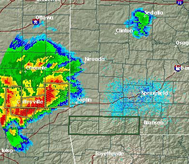
Deadliest U.S. tornado since 1953 rips through Joplin, Missouri, killing 89
The incredibly violent tornado season of 2011 struck another sickening blow last night, when a violent tornado carved a ½ – ¾ mile-wide path of devastation through Joplin, Missouri. At least 89 people died, hundreds were injured, and huge sections of the town virtually obliterated. Damage from the tornado is so severe that pavement was ripped from the ground, which is characteristic of a top-end EF-5 tornado with winds in excess of 200 mph. This was almost certainly a least an EF-4 tornado with winds over 166 mph, and the level of damage is so extreme that this is likely to surpass last month's Tuscaloosa-Birmingham tornado as the costliest tornado of all-time.
Figure 1. Cars stacked on top of each other in front of the heavily damaged St. Johns Regional Medical Center after the May 22, 2011 tornado in Joplin, Missouri. Note the pavement ripped up from the road and piled in front of the cars. Tornadoes powerful enough to rip up pavement are frequently classified as EF-5 with winds in excess of 200 mph. Image credit: Chris McCrillis, posted to Twitter.
The huge supercell thunderstorm that spawned the Joplin tornado formed over extreme southeast Kansas yesterday afternoon, along the boundary between warm, moist air flowing northwards from the Gulf of Mexico, and cold, dry air moving south from Canada. NOAA's Storm Prediction Center (SPC) had put the region in its “moderate risk” region for severe weather. As the supercell moved into Southwest Missouri, it spawned the tornado that roared through Joplin at 5:45pm CDT. This storm generated other tornadoes, straight-line wind damage, and flash flooding from torrential rains that exceeded six inches as it moved east southeast across Southwest Missouri. SPC recorded 48 preliminary reports of tornadoes yesterday, bringing the 2-day total for the current outbreak to 70. A tornado also killed one person and injured 22 in Minneapolis Sunday. Separate tornadoes killed one person each in Andice, Texas and Reading, Kansas on Saturday—the first tornado deaths in the U.S. since the April 25 – 28 Super Outbreak.
Figure 2. Radar reflectivity image of the supercell thunderstorm that spawned the Joplin, Missouri tornado, ½ hour after it devastated the city (circle with the “+” symbol.)
Figure 3. Radar Doppler velocity image of the supercell thunderstorm that spawned the Joplin, Missouri tornado, ½ hour after it devastated the city (circle with the “+” symbol.)
Figure 4. Satellite image taken at 5:45pm CDT May 22, 2011, when the Joplin, Missouri tornado was occurring. Image credit: NASA/GSFC.
Deadliest tornado since 1953
Yesterday's Joplin, Missouri tornado is the deadliest single tornado in the U.S. since June 10, 1953, when 94 people died in the Worcester, Massachusetts tornado. The previous deadliest tornado in the past 50 years occurred just last month, when 65 people died in the Tuscaloosa-Birmingham EF-4 tornado in Alabama. This year's tornado death toll now stands at 455, making it the deadliest year for tornadoes in the U.S. since 1953, when 519 people died. The deadliest year was 1925, with 794 deaths. That was the year of the deadliest U.S. tornado of all-time, the great Tri-State tornado, which killed 695 people in Missouri, Illinois, and Indiana.
Wunderground
The incredibly violent tornado season of 2011 struck another sickening blow last night, when a violent tornado carved a ½ – ¾ mile-wide path of devastation through Joplin, Missouri. At least 89 people died, hundreds were injured, and huge sections of the town virtually obliterated. Damage from the tornado is so severe that pavement was ripped from the ground, which is characteristic of a top-end EF-5 tornado with winds in excess of 200 mph. This was almost certainly a least an EF-4 tornado with winds over 166 mph, and the level of damage is so extreme that this is likely to surpass last month's Tuscaloosa-Birmingham tornado as the costliest tornado of all-time.
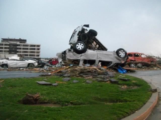
Figure 1. Cars stacked on top of each other in front of the heavily damaged St. Johns Regional Medical Center after the May 22, 2011 tornado in Joplin, Missouri. Note the pavement ripped up from the road and piled in front of the cars. Tornadoes powerful enough to rip up pavement are frequently classified as EF-5 with winds in excess of 200 mph. Image credit: Chris McCrillis, posted to Twitter.
The huge supercell thunderstorm that spawned the Joplin tornado formed over extreme southeast Kansas yesterday afternoon, along the boundary between warm, moist air flowing northwards from the Gulf of Mexico, and cold, dry air moving south from Canada. NOAA's Storm Prediction Center (SPC) had put the region in its “moderate risk” region for severe weather. As the supercell moved into Southwest Missouri, it spawned the tornado that roared through Joplin at 5:45pm CDT. This storm generated other tornadoes, straight-line wind damage, and flash flooding from torrential rains that exceeded six inches as it moved east southeast across Southwest Missouri. SPC recorded 48 preliminary reports of tornadoes yesterday, bringing the 2-day total for the current outbreak to 70. A tornado also killed one person and injured 22 in Minneapolis Sunday. Separate tornadoes killed one person each in Andice, Texas and Reading, Kansas on Saturday—the first tornado deaths in the U.S. since the April 25 – 28 Super Outbreak.
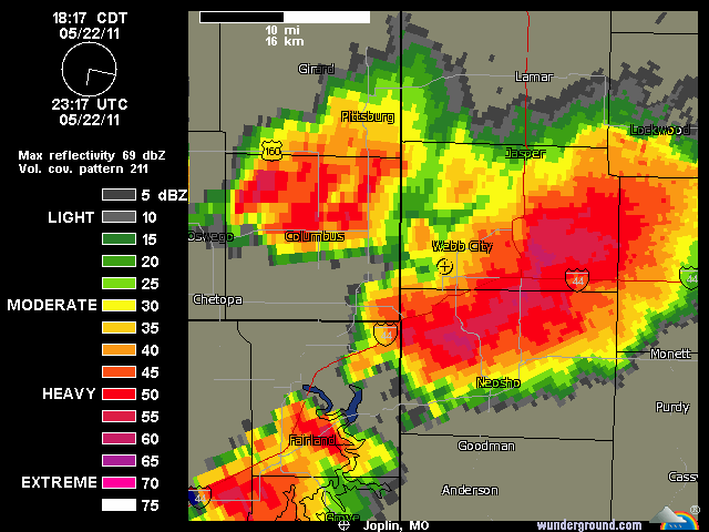
Figure 2. Radar reflectivity image of the supercell thunderstorm that spawned the Joplin, Missouri tornado, ½ hour after it devastated the city (circle with the “+” symbol.)
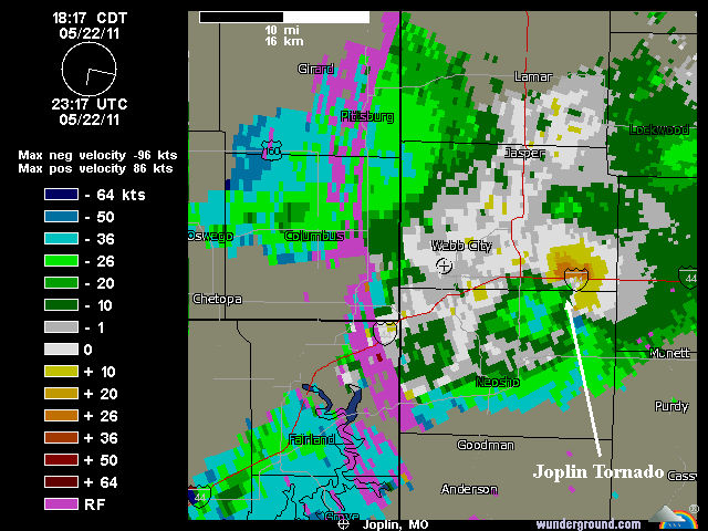
Figure 3. Radar Doppler velocity image of the supercell thunderstorm that spawned the Joplin, Missouri tornado, ½ hour after it devastated the city (circle with the “+” symbol.)
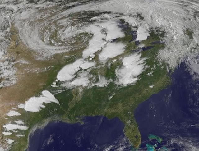
Figure 4. Satellite image taken at 5:45pm CDT May 22, 2011, when the Joplin, Missouri tornado was occurring. Image credit: NASA/GSFC.
Deadliest tornado since 1953
Yesterday's Joplin, Missouri tornado is the deadliest single tornado in the U.S. since June 10, 1953, when 94 people died in the Worcester, Massachusetts tornado. The previous deadliest tornado in the past 50 years occurred just last month, when 65 people died in the Tuscaloosa-Birmingham EF-4 tornado in Alabama. This year's tornado death toll now stands at 455, making it the deadliest year for tornadoes in the U.S. since 1953, when 519 people died. The deadliest year was 1925, with 794 deaths. That was the year of the deadliest U.S. tornado of all-time, the great Tri-State tornado, which killed 695 people in Missouri, Illinois, and Indiana.
Wunderground
 Op
Op
holy shit, wat erg weer ditquote:
 Op
Op
Altijd de sarcasme modus aan
pfff, ik ben even stil na het zien van deze beelden.
You better lose yourself in the music
The moment, you own it, you better never let it go
The moment, you own it, you better never let it go
inmiddels weer een moderate risk, met als ik 't goed zie in oklahoma een 10% tornado risk, volgens de stormtracker op news9
Altijd de sarcasme modus aan
hallo,
ik probeer de streams ook een beetje te volgen, maar heb er nog niet één gevonden met geluid.
Hoe kom ik aan geluid, zodat ik een beetje kan volgen of ze een storm zien aankomen
ik probeer de streams ook een beetje te volgen, maar heb er nog niet één gevonden met geluid.
Hoe kom ik aan geluid, zodat ik een beetje kan volgen of ze een storm zien aankomen
“Loop niet voor me, want ik volg niet.
Loop niet achter me, want ik leid niet.
Loop gewoon naast me en wees mijn vriend.”
Loop niet achter me, want ik leid niet.
Loop gewoon naast me en wees mijn vriend.”
Hallo Kaatje, Brett Adair heeft geluid en zit ook in het gebied van Oklahoma City, Tulsa en Kansas City dat we vandaag in de gaten kunnen houdenquote:
hallo,
ik probeer de streams ook een beetje te volgen, maar heb er nog niet één gevonden met geluid.
Hoe kom ik aan geluid, zodat ik een beetje kan volgen of ze een storm zien aankomen
You better lose yourself in the music
The moment, you own it, you better never let it go
The moment, you own it, you better never let it go
ze hebben niet allemaal geluid kaatje, je moet de kaart ook een beetje in de gaten houden, en je kunt ook vaak aan het aantal kijkers op een stream zien waar "aktie" is.quote:
hallo,
ik probeer de streams ook een beetje te volgen, maar heb er nog niet één gevonden met geluid.
Hoe kom ik aan geluid, zodat ik een beetje kan volgen of ze een storm zien aankomen
Altijd de sarcasme modus aan
Ik heb het gemist, wat zei hij/zij?quote:
Pfff die Nederlander die daar woont net op Nederland 3
Dit is nog erger lijkt me?quote:
Het doet me altijd weer denken aan Greensburg.
's Avonds een man, overdags rustig an
Greensburg was inderdaad een klein stadje wat compleet werd verwoest. Zie de foto in de OP.
Het is een wonder dat daar toen niet meer slachtoffers bij zijn gevallen. Het lijkt wel alsof de kleinere dorpjes beter zijn voorbereid op een tornado dan een grotere stad.
[ Bericht 0% gewijzigd door #ANONIEM op 23-05-2011 23:09:41 ]
Het is een wonder dat daar toen niet meer slachtoffers bij zijn gevallen. Het lijkt wel alsof de kleinere dorpjes beter zijn voorbereid op een tornado dan een grotere stad.
[ Bericht 0% gewijzigd door #ANONIEM op 23-05-2011 23:09:41 ]