WKN Weer, Klimaat en Natuurrampen
Lees alles over het onstuimige weer op onze planeet, volg orkanen en tornado's, zie hoe vulkanen uitbarsten en hoe Moeder Aarde beeft bij een aardbeving. Alles over de verwoestende kracht van onze planeet en tal van andere natuurverschijnselen.


 Op
Op 
zie het, daar gaat m'n laatste peuk, nog effe volgen dit hoorquote:Op dinsdag 26 april 2011 01:11 schreef kahaarin het volgende:
[..]
Dat ja, en WFAA is af en aan weer bij het weer.
Altijd de sarcasme modus aan

quote:Op dinsdag 26 april 2011 01:18 schreef Ceetje.. het volgende:
[..]
zie het, daar gaat m'n laatste peuk, nog effe volgen dit hoor
be nice or go away


Bron: http://www.nbcdfw.com/wea(...)-Rose-120648339.htmlquote:Severe Storms Spin Off Funnels
Monday's severe thunderstorms spawned at least a half-dozen tornadoes seen by storm spotters and also produced small hail through much of the Metroplex on Monday.
The twisters and funnel clouds Monday afternoon were weak and, for the most part, struck open country south of the Dallas-Fort Worth.
In Ellis County, five people were reportedly left homeless when a suspected tornado tore the roof from their mobile home in Avalon, said John Patterson, the county's emergency management coordinator.
The people live next the high school in Avalon and took shelter in the school's domed gymnasium. The school sustained roof damage, but the gym was not damaged.
Patterson said six to eight other homes were also damaged.
Multimedia
In Navarro County, a volunteer firefighter reported that a shed blew over in the eastern part of the county. Downed trees and damage to barns and buildings north of Blooming Grove were also reported.
Erath County Sheriff Tommy Bryant said a barn and a vacant home were destroyed on FM 205 near Stephenville. No injuries were reported.
A funnel formed briefly around midafternoon Monday about 30 miles southwest of Fort Worth, between Cleburne and Glen Rose. It was unclear how long it was on the ground, but spotters reported that it touched down briefly. A thin, rope-like funnel was later seen near Itasca, about 50 miles southwest of Dallas.
By the early afternoon, the storms sparked large hail, severe thunderstorm warnings and tornado warnings across much of North Texas.
Golf ball-sized hail was reported over Glen Rose. Hail reports varied from marble- to tennis ball-sized and were widespread across the Metroplex.
The storms were associated with an atmospheric boundary between moist and dry air and a stationary front that has been oscillating between North Texas and southern Oklahoma.
National Weather Service meteorologist David Huckaby in Fort Worth said the storm was cyclical, meaning that as one end was losing strength, the other end was regenerating. That kept the storm raging all afternoon long until after sunset, when the heat that fueled it was lost.
However, Huckaby said more of the same was expected Tuesday in North Texas.
By Wednesday, quiet weather is expected to return and stay until the end of the work week.
Outside of North Texas, multiple suspected tornadoes were reported in and around Crockett in East Texas at about 9:30 p.m. Widespread damage was reported countywide, but the severity was unclear because many affected areas were without power, Houston County Fire Marshal David Lamb said. Many trees also had been blown down, either by tornadoes or straight-line winds, he said.
- Klikken op de link voor foto's + filmpjes
[ Bericht 4% gewijzigd door Drassss op 26-04-2011 08:58:07 ]
Doden door noodweer Arkansas
Door noodweer in de Amerikaanse staat Arkansas zijn zeker vijf mensen om het leven gekomen. In de aangrenzende staat Missouri zijn duizenden mensen geëvacueerd wegens wateroverlast.
Drie van de slachtoffers kwamen om het leven doordat hun auto's werden meegesleurd door het hoge water. De twee anderen kwamen om door tornado's, waarvan er zo'n vijftien gemeld werden. Een tornado verwoestte wel honderd huizen in de staat.
De gouverneur van Arkansas heeft de noodtoestand uitgeroepen, omdat de stormen en overstromingen al dagen aanhouden. Veel wegen zijn onbegaanbaar geworden.
Meer regen
Ook in de aangrenzende staat Missouri zijn veel wegen overstroomd. Daar zijn uit voorzorg honderden mensen geëvacueerd omdat een rivier dreigde te overstromen.
De regio verwacht de komende dagen nog meer neerslag. Tot en met donderdag kan er op sommige plekken wel 22 centimeter regen vallen.
Twee weken geleden vielen door extreem noodweer 45 doden in zes zuidelijk staten.
NOS
Dit is echt bizar, las op twitter al wel dat het op de radar nog nooit zo eruit gezien te hebben en daar bedoel ik mee de vorm. Er gaan geruchten op twitter rond dat het een EF5 is geweest..

Weer of geen weer, altijd actueel www.onweer-online.nl
Deze tornado zou 5 km breed zijn geweest... Ik kan het bijna niet geloven.
's Avonds een man, overdags rustig an


Men zegt wel dat het stadje compleet weggeveegd is. Over een paar uur is het daar echt goed ligt en kan men de schade opmaken...
Geloof dat er meer dan 100 huizen zijn verwoest, moment zal t uitgebreide artikel wel even neerzetten hier.quote:Op dinsdag 26 april 2011 12:55 schreef Drassss het volgende:
Men zegt wel dat het stadje compleet weggeveegd is. Over een paar uur is het daar echt goed ligt en kan men de schade opmaken...
Weer of geen weer, altijd actueel www.onweer-online.nl
Tornado's en overstromingen met dodelijke afloop in USA
Door noodweer in de Amerikaanse staat Arkansas zijn zeker vijf mensen om het leven gekomen. In de aangrenzende staat Missouri zijn duizenden mensen geëvacueerd wegens wateroverlast.
Johnson, Arkansas
Wateroverlast
Drie van de slachtoffers kwamen om het leven doordat hun auto's werden meegesleurd door het hoge water. In het zuidoosten van Missouri dreigt de oververzadigde dijk rond de Black River doortebreken. In het stadje Poplar Bluff stroomt het troebele water op meer dan 36 plaatsen over de dijk. Sommige huizen zijn reeds ondergelopen. Ongeveer 1.000 huishoudens zijn geëvacueerd en als de dijk doorbreekt zullen er in totaal 7.000 mensen naar veiliger gebied moeten vluchten. Het is niet mogelijk om zandzakken op de dijk te plaatsen, omdat de dijk al helemaal doordrenkt is. Het is bijzonder gevaarlijk om mensen op de dijk te plaatsen.
In Madison County zijn een man en een vrouw overleden, doordat het water hun auto van de weg afduwde en meesleurde met de stroming. In Washington County is een vrouw op dezelfde wijze om het leven gekomen. Haar elf jaar oude zoon overleefde het ongeluk. Iedere dag moeten reddingswerkers minstens 10 keer uitrukken om mensen te redden, die in nood zijn gekomen door het water. "Het heeft zo hard geregend en het water is zo snel gestegen, dat het de mensen heeft verrast," zegt de politiechef. "Toen we de wegen inspecteerden, nadat het water een beetje was gezakt, merkten we dat er grote delen van de wegen waren weggespoeld". Het wordt verwacht, dat de Black River nog hoger zal stijgen dan in 2008, toen er ook grote overstromingen waren.
Gedeeltes van twee staatsparken in het noordwesten van Arkansas zijn gesloten wegens het rijzen van de rivier. Een groot aantal scholen zijn gesloten. Gedeeltes van Utica in het zuiden van Indiana en de stad Louisville, Kentucky, hebben ook te maken met overstromingen. Het is de ergste wateroverlast sinds 1997. Tevens zijn er overstromingen gemeld in het westen van Kentucky en het zuiden van Illinois. Mensen, die in de buurt van de Ohio rivier nabij Louisville zijn begonnen met evacueren. Enkele wegen rond de stad zijn al afgesloten. Meer problemen worden ook verwacht langs de Taneycomo rivier in het zuidwesten van Missouri.
Bron: Twitpic
Tornado's
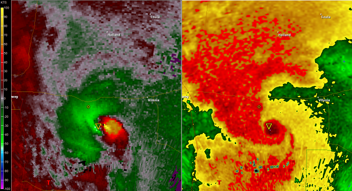
Op maandagavond zijn er meer dan een dozijn tornado's werden gemeld in Texas en Arkansas. In het overwegend landelijk Houston County in het oosten van Texas is op grote schaal schade gemeld, maar de daadwerkelijke ernst van de schade was nog niet goed in te schatten, omdat grote delen van het gebied nog zonder stroom zitten. In het 38.000 inwoners tellende Vilanio, Arkansas, heeft een grote tornado zeker 50 tot 80 huizen compleet verwoest en is er helaas ook een dode te betreuren. Het aantal vermisten schommelt tussen de 40 en 50. De politiechef verwacht echter niet, dat het dodental op zal lopen. "De mensen kunnen gewoonweg niet bereikt worden", zegt hij. Stormspotters melden, dat de tornado halve mijl breed was en dat de vorm op de radarbeelden van deze tornado één van de duidelijkste en heftigste was, die ze ooit hebben gezien.
Radar & Base Velocity Side-By-Side. Picture courtesy of Tornadovideos.net
Auto's werden op de I-40 nabij het stadje Vilonia van de weg af geblazen. De stoeptegels uit Vilonia liggen tot in de verre omtrek verspreid. De lokale autoriteiten melden, dat de stad compleet verwoest is. Buiten de eerder gemelde dode zijn er gelukkig weinig berichten van gewonden. De tornado sirenes zijn 20 minuten van te voren afgegaan.
De beelden van puin op de radar laten een sterke rotatie zien op de I-40 ten noordwesten van Little Rock nabij Mayflower. De "puinbal" op de radarbeelden lijkt, volgens The Weather Channel, op die van de puinbal van de St. Louis tornado van afgelopen vrijdag, welke onofficieel als een EF4 wordt beschouwd. Het rondvliegende puin was gedurende 30 minuten op de radar te volgen:
Bron: 28 storms
In Morgen, Arkansas, net ten noordwesten van Little Rock is een kerk volledig verwoest. Een tornado heeft de militaire vliegbasis in Little Rock geraakt. Er zijn op de basis minstens 2 mensen lichtgewond geraakt en zijn er 16 huizen en een vliegtuig beschadigd. Ook viel de stroom uit. In de gehele staat zijn er meer dan 100.000 mensen zonder stroom komen te zitten. In verschillende gedeeltes van de staten zijn berichten binnen gekomen over omvergeblazen auto's, bomen en elektriciteitspalen.
Noodtoestand
De gouverneur van Arkansas heeft de noodtoestand uitgeroepen, omdat de stormen en overstromingen al dagen aanhouden. Veel wegen zijn onbegaanbaar geworden. De regio verwacht de komende dagen nog meer neerslag. Tot en met donderdag kan er op sommige plekken wel 22 centimeter regen vallen. Nixon uit kritiek op de U.S. Army Corps of Engineers, met hun plannen om de Birds Point dijk aan Mississippi rivier in het zuidoosten van Missouri preventief door te breken. Hij zegt, dat dit honderden families zal treffen en het een enorme plens met water over 5,3 hectare landbouwgrond zou uitstorten. De schade is niet te overzien. Het Corps of Engineers was niet direct bereikbaar voor commentaar.
©onweer-online
Door noodweer in de Amerikaanse staat Arkansas zijn zeker vijf mensen om het leven gekomen. In de aangrenzende staat Missouri zijn duizenden mensen geëvacueerd wegens wateroverlast.

Johnson, Arkansas
Wateroverlast
Drie van de slachtoffers kwamen om het leven doordat hun auto's werden meegesleurd door het hoge water. In het zuidoosten van Missouri dreigt de oververzadigde dijk rond de Black River doortebreken. In het stadje Poplar Bluff stroomt het troebele water op meer dan 36 plaatsen over de dijk. Sommige huizen zijn reeds ondergelopen. Ongeveer 1.000 huishoudens zijn geëvacueerd en als de dijk doorbreekt zullen er in totaal 7.000 mensen naar veiliger gebied moeten vluchten. Het is niet mogelijk om zandzakken op de dijk te plaatsen, omdat de dijk al helemaal doordrenkt is. Het is bijzonder gevaarlijk om mensen op de dijk te plaatsen.
In Madison County zijn een man en een vrouw overleden, doordat het water hun auto van de weg afduwde en meesleurde met de stroming. In Washington County is een vrouw op dezelfde wijze om het leven gekomen. Haar elf jaar oude zoon overleefde het ongeluk. Iedere dag moeten reddingswerkers minstens 10 keer uitrukken om mensen te redden, die in nood zijn gekomen door het water. "Het heeft zo hard geregend en het water is zo snel gestegen, dat het de mensen heeft verrast," zegt de politiechef. "Toen we de wegen inspecteerden, nadat het water een beetje was gezakt, merkten we dat er grote delen van de wegen waren weggespoeld". Het wordt verwacht, dat de Black River nog hoger zal stijgen dan in 2008, toen er ook grote overstromingen waren.
Gedeeltes van twee staatsparken in het noordwesten van Arkansas zijn gesloten wegens het rijzen van de rivier. Een groot aantal scholen zijn gesloten. Gedeeltes van Utica in het zuiden van Indiana en de stad Louisville, Kentucky, hebben ook te maken met overstromingen. Het is de ergste wateroverlast sinds 1997. Tevens zijn er overstromingen gemeld in het westen van Kentucky en het zuiden van Illinois. Mensen, die in de buurt van de Ohio rivier nabij Louisville zijn begonnen met evacueren. Enkele wegen rond de stad zijn al afgesloten. Meer problemen worden ook verwacht langs de Taneycomo rivier in het zuidwesten van Missouri.

Bron: Twitpic
Tornado's
Op maandagavond zijn er meer dan een dozijn tornado's werden gemeld in Texas en Arkansas. In het overwegend landelijk Houston County in het oosten van Texas is op grote schaal schade gemeld, maar de daadwerkelijke ernst van de schade was nog niet goed in te schatten, omdat grote delen van het gebied nog zonder stroom zitten. In het 38.000 inwoners tellende Vilanio, Arkansas, heeft een grote tornado zeker 50 tot 80 huizen compleet verwoest en is er helaas ook een dode te betreuren. Het aantal vermisten schommelt tussen de 40 en 50. De politiechef verwacht echter niet, dat het dodental op zal lopen. "De mensen kunnen gewoonweg niet bereikt worden", zegt hij. Stormspotters melden, dat de tornado halve mijl breed was en dat de vorm op de radarbeelden van deze tornado één van de duidelijkste en heftigste was, die ze ooit hebben gezien.
Radar & Base Velocity Side-By-Side. Picture courtesy of Tornadovideos.net
Auto's werden op de I-40 nabij het stadje Vilonia van de weg af geblazen. De stoeptegels uit Vilonia liggen tot in de verre omtrek verspreid. De lokale autoriteiten melden, dat de stad compleet verwoest is. Buiten de eerder gemelde dode zijn er gelukkig weinig berichten van gewonden. De tornado sirenes zijn 20 minuten van te voren afgegaan.
De beelden van puin op de radar laten een sterke rotatie zien op de I-40 ten noordwesten van Little Rock nabij Mayflower. De "puinbal" op de radarbeelden lijkt, volgens The Weather Channel, op die van de puinbal van de St. Louis tornado van afgelopen vrijdag, welke onofficieel als een EF4 wordt beschouwd. Het rondvliegende puin was gedurende 30 minuten op de radar te volgen:

Bron: 28 storms
In Morgen, Arkansas, net ten noordwesten van Little Rock is een kerk volledig verwoest. Een tornado heeft de militaire vliegbasis in Little Rock geraakt. Er zijn op de basis minstens 2 mensen lichtgewond geraakt en zijn er 16 huizen en een vliegtuig beschadigd. Ook viel de stroom uit. In de gehele staat zijn er meer dan 100.000 mensen zonder stroom komen te zitten. In verschillende gedeeltes van de staten zijn berichten binnen gekomen over omvergeblazen auto's, bomen en elektriciteitspalen.
Noodtoestand
De gouverneur van Arkansas heeft de noodtoestand uitgeroepen, omdat de stormen en overstromingen al dagen aanhouden. Veel wegen zijn onbegaanbaar geworden. De regio verwacht de komende dagen nog meer neerslag. Tot en met donderdag kan er op sommige plekken wel 22 centimeter regen vallen. Nixon uit kritiek op de U.S. Army Corps of Engineers, met hun plannen om de Birds Point dijk aan Mississippi rivier in het zuidoosten van Missouri preventief door te breken. Hij zegt, dat dit honderden families zal treffen en het een enorme plens met water over 5,3 hectare landbouwgrond zou uitstorten. De schade is niet te overzien. Het Corps of Engineers was niet direct bereikbaar voor commentaar.
©onweer-online
Weer of geen weer, altijd actueel www.onweer-online.nl
quote:ARKANSAS (KTHV) -- Emergency officials in Arkansas have confirmed two more storm-related fatalities, bringing the death toll to seven statewide.
The Faulkner County Sheriff's Department has confirmed that four people have died in Faulkner County. Arkansas Department of Emergency Management spokesman Tommy Jackson says two of those people died in Vilonia, where a tornado likely ripped through the area.
The Vilonia fire chief says that 12 people are currently unaccounted for after storms hit central Ark. community. Officials will be going door to door later this morning checking on residents. THV's Ashley Blackstone is live in Vilonia and will have more on "Today's THV This Morning".
In northwest Arkansas, emergency officials say a man and a woman died after floodwaters swept their car off the road in Madison County. Another woman, 38-year-old Consuelo Santillano, died near after her car was swept off the road in Washington County. Santillano's 11-year-old son survived.
Damage Reports
In Pulaski County, in the Morgan/Maumelle area at Highway 365 and Settlement, the Mount Pleasant Church was demolished. In same area a tree fell on a house trapping a man, but he wasn't injured.
Heifer Ranch in Perryville was also hit. According to Michelle Izaguirre, Senior Director of Learning Centers, all Ranch employees, volunteers and guests are safe. The volunteers and guests have been in communication with their families. There is property damage to buildings, barns and fences.
Rescue crews and the local fire department were at the Ranch as of 9:30 p.m. CT on Monday, clearing trees from the roads and checking downed power lines. There is no electricity on the Ranch at this time, and the phone system is down. Staff is currently checking the status of all animals. Once trees are cleared, further assessment of the lower pasture and garden area will be possible.
Damage reported near Brady Mtn. Law enforcement reporting trees down near Amity. Damage also reported near Hot Springs County along highway 270. Montgomery co sheriff: homes severely damaged at Old Dallas & Caddo Gap Rd.
Garland County has had severe damage this evening from the storms. The following areas are the ones we know of so far: Walnut Valley Road, Ranch Estates Subdivision, Oates Loop, Vaughn Road, and Fox Pass Road in the Hwy 7North area. In the west side of the county the areas are Ragweed Valley Road, Sunshine Road, Powell Road, Old Dallas Road, Oakgrove Road, and Brady Mtn Road area.
Also, reports from Lake Ouachita State Park and Teen Challenge having damage. Some reports of minor injuries. Numerous power lines and trees down county wide; there are lots of debris in the roadways. The sheriff's office is now getting reports of flooding in the Fox Pass Road, Ragweed Valley Road, and Surry Road areas, as well as creeks and low lying areas. Most of these areas are blocked and emergency crews are trying to gain access. Damage has also been reported to several houses in Garland County, near Fountain Lake. Several people have also been reported injured.
There are also reports of 2 people injured in the Sunshine community in Garland. There are power lines down all over Saline County.
Over in Jacksonville, North Pulaski High School has sustained major structural damage and will be closed today. THV's Faith Abubey is live there and will have more information on "Today's THV This Morning."
The Little Rock Air Force Base is reporting at least four homes in base housing have been damaged.
Crews are assessing the base's aircraft at this time. Base housing residents are encouraged to stay indoors due to downed power lines in base housing. Base residents who are experiencing emergencies should call 987-6123 so base officials can assist.
Gov. Mike Beebe has declared a state of emergency, retroactive to April 19, when another series of violent storms moved through Arkansas. Beebe will be touring parts of the state affected by the storm sometime after daybreak.
Entergy Arkansas reporting roughly 66,000 customers currently in the dark. First Electric Cooperative reports 14,000 outages in White, Saline, Lonoke, Pulaski and Perry counties.

Lijkt me ook niet. Ik las net iets van een halve mijl, dat is realistischer (dat is nog bijna een km. breed!).quote:
5 km is wel heel erg breed, dat kan volgens mij niet.
's Avonds een man, overdags rustig an
Ik denk dat ik snap waar de verwarring vandaan komt over hoe breed de tornado was, een tornado van een halve mijl breed kan natuurlijk best voor schade zorgen in een straal van 5 km, denk dan aan neerstortend puin, de harde winden eromheen, de inflow, etc. Er staat niet dat de tornado 5 km breed was.quote:Doden door noodweer in Arkansas
Uitgegeven: 26 april 2011 12:27
Laatst gewijzigd: 26 april 2011 13:32
LITTLE ROCK - Zeker vijf mensen zijn maandag om het leven gekomen door noodweer in de Amerikaanse staat Arkansas. Dat meldden Amerikaanse media dinsdag.
© NU.nl/Petra Glorie
Bekijk video
Vooral het centraal gelegen stadje Vilonia werd zwaar getroffen. Een vermoedelijke tornado trok daar een spoor van vernieling van bijna 5 kilometer breed en 24 kilometer lang.
Volgens de hulpdiensten kwamen daarbij twee mensen om en werden tussen de vijftig en de tachtig woningen vernield. ''De stad is weg'', aldus een inwoner. Op andere plekken werden mensen in hun auto van de weg gespoeld, toen een beek buiten zijn oevers trad.
Noodtoestand
De gouverneur van Arkansas, Mike Beebe, riep in de nacht van maandag op dinsdag de noodtoestand uit. Meer dan honderdduizend mensen zitten zonder elektriciteit. Enkele tientallen mensen zijn nog vermist, maar de autoriteiten vermoeden dat de meesten van hen zich nog niet hebben kunnen melden.

be nice or go away
Ik denk dat je gelijk hebt kahaarin. 5Km breed zou allesverwoestend zijn, dan waren er meer dan 5 doden.
's Avonds een man, overdags rustig an

Gatver, weer precies in hetzelfde gebied....quote:
En we hebben weer een High Risk
[ afbeelding ]
be nice or go away
Die van Greensburg (aantal jaar terug) was volgens mij 800 meter breed. Veel breder worden ze volgens mij niet.quote:
Ik denk dat je gelijk hebt kahaarin. 5Km breed zou allesverwoestend zijn, dan waren er meer dan 5 doden.
Breedste tornado ooit was geloof ik 4 kilometer. Moment even zoeken naar stukjequote:
[..]
Die van Greensburg (aantal jaar terug) was volgens mij 800 meter breed. Veel breder worden ze volgens mij niet.
Edit:
What was the largest tornado ever recorded in the US in terms of width of path?
A tornado which affected Hallam, Nebraska on May 22, 2004 was at one point 2.5 miles (4 km) wide at the ground
Weer of geen weer, altijd actueel www.onweer-online.nl
Ik zat ook al te zoeken.quote:
[..]
Breedste tornado ooit was geloof ik 4 kilometer. Moment even zoeken naar stukje
Greensburg was 2.7 km
http://en.wikipedia.org/wiki/Greensburg,_Kansas

Weer of geen weer, altijd actueel www.onweer-online.nl
quote:The widest tornado (defined as damage path, not condensation/debris cloud or radar measurements) on record is the Wilber - Hallam, Nebraska tornado during the outbreak of May 22, 2004, with a width of 2.5 miles (4 km) at its peak.[14]
The widest tornado as measured by actual radar wind measurements was the Mulhall (1999) tornado in northern Oklahoma which occurred during the 1999 Oklahoma tornado outbreak. The diameter of the maximum winds (over 110 metres per second (250 mph)) was over 1600 m as measured by a DOW radar. Although the tornado passed largely over rural terrain, the width of the wind swath capable of producing damage was as wide as 4 miles (7 km), making the actual wind field of the Mulhall tornado likely twice as wide as that of the Hallam tornado (the wind field of which was not measured), even though the Hallam tornado resulted in a wider damage path.
Dat is dus het record, dan lijkt het me veilig om aan te nemen dat die in Vilonia niet 5 km was.quote:
[..]
Breedste tornado ooit was geloof ik 4 kilometer. Moment even zoeken naar stukje
Edit:
What was the largest tornado ever recorded in the US in terms of width of path?
A tornado which affected Hallam, Nebraska on May 22, 2004 was at one point 2.5 miles (4 km) wide at the ground
be nice or go away