WKN Weer, Klimaat en Natuurrampen
Lees alles over het onstuimige weer op onze planeet, volg orkanen en tornado's, zie hoe vulkanen uitbarsten en hoe Moeder Aarde beeft bij een aardbeving. Alles over de verwoestende kracht van onze planeet en tal van andere natuurverschijnselen.


Type: Earthquake
19 hours ago
Magnitude: 1.4
DateTime: Monday April 18 2011, 19:14:20 UTC
Region: Yellowstone National Park, Wyoming
19 hours ago
Magnitude: 1.4
DateTime: Monday April 18 2011, 19:14:20 UTC
Region: Yellowstone National Park, Wyoming
Een 1.4?quote:Op dinsdag 19 april 2011 16:47 schreef Scrummie het volgende:
Type: Earthquake
19 hours ago
Magnitude: 1.4
DateTime: Monday April 18 2011, 19:14:20 UTC
Region: Yellowstone National Park, Wyoming
Dat gebeurt elke dag wel een keer daar.
Oh oke, vandaar dat deze wel word gemeld en de rest niet?quote:
[..]
Een 1.4?
Dat gebeurt elke dag wel een keer daar.
20-04-2011
Supervulkaan Yellowstone monstergroot
Explosief nieuws uit de wetenschap. Met een nieuwe methode kunnen onderzoekers beter schatten hoe groot de vulkaan Yellowstone (VS) nu precies is in de ondergrond. Het blijkt te gaan om 640 km van oost naar west, ruim tweemaal de lengte van Nederland. Met recht een ‘supervulkaan’ dus.
De bekendste supervulkaan ter wereld? Dan gaat het over Yellowstone in de Amerikaanse staat Wyoming die begin dit jaar weer eens in het nieuws kwam omdat de aarde in het gebied opeens flink rees. Wetenschappers hebben nu bepaald hoe groot de supervulkaan eigenlijk is: 640 km van oost naar west, wat groter is dan gedacht. Michael Zhdanov en collega’s van de Universiteit van Utah (VS) publiceren hierover in een nog te verschijnen artikel in Geophysical Research Letters.
De verspreiding van de aslaag door de superuitbarstingen van 2,0 (Huckleberry Ridge), 1,3 (Mesa Falls) en 0,64 (Lava Creek) miljoen jaar geleden. Afbeelding: © USGS
.Yellowstone
Waarom is Yellowstone zo bekend? Als de supervulkaan Yellowstone ooit weer uitbarst zoals dit 0,64, 1,3 en 2,0 miljoen jaar geleden gebeurde, dan ligt een groot deel van de VS letterlijk in zak en as. As van de laatste grote uitbarsting bedekte de helft van de VS. Niet alleen komt het vliegverkeer en het openbare leven ter plaatse daarmee lam te liggen, maar de effecten zullen mogelijk decennialang duren. Temperaturen zullen wereldwijd dalen en meer zure regen zal vallen.
Geleidbaarheid
Het magma dat de vulkaan voedt, komt van grote diepte, mogelijk zelfs van dichtbij de aardkern/aardmantel grens 2900 km beneden onze voeten. Eenmaal dichtbij het aardoppervlak gekomen, komt het magma in een magmakamer terecht. Vanwege de grootte van Yellowstone gaat dat echter niet helemaal op, want in feite is Yellowstone’s magmakamer een langgerekte pluim. Zhdanov en collega’s keken naar de elektrische geleidbaarheid van de gesteenten in de diepe aarde. Die verandert namelijk onder invloed van de temperatuur, water, gesmolten gesteente en de samenstelling van het gesteente.
De pluim in de ondergrond van Yellowstone op basis van de elektrische geleidbaarheid. Geel en rood stellen een hoge geleidbaarheid voor door meer gesmolten gesteente en heet, zouter water; blauw en groen een lage. Afbeelding: © American Geophysical Union
.Op basis van data van 115 meetpunten maakten de onderzoekers zo de pluim onder Yellowstone én de verre omgeving zichtbaar. Dat laatste is maar goed ook, want anders hadden ze een groot gedeelte gemist. Een gedeelte van de pluim ligt namelijk onder de staat Montana, maar vooral ook onder Idaho. De lengte is duizelingwekkend met 640 km: meer dan tweemaal de lengte van Nederland.
Nieuw?
Het onderzoeken van de grootte van pluim in de ondergrond is niet nieuw. In 2009 onderzochten wetenschappers dit ook al, maar dan met aardbevingsgolven (in dit geval P-golven) die langzamer reizen door warmer/gesmolten gesteente. Dit team kwam uit op 240 km breedte, een stukje minder dan wat Zhdanov en collega’s vonden. De pluim in het onderzoek van 2009 ging daarnaast ook steiler diepte in.
De pluim uit het nieuwe artikel is veel gedetailleerder voor de bovenste 320 km, maar daaronder werkt de andere methode vooralsnog beter. Ondanks het verschil in uitkomst tussen de twee methoden is het algemene beeld hetzelfde: de pluim duikt naar het westen toe weg in de aarde.
Een vergelijking tussen de pluim van Yellowstone getoond door middel van verschillen in elektrische geleidbaarheid (links) en middels verschillen in de voortplantingsnelheid van aardbevingsgolven die door de aarde reizen (rechts). Afbeelding: © American Geophysical Union
Toepassing
“In principe is het mogelijk om veranderingen te monitoren,” vertelt Zhdanov ons over zijn methode. “Je hebt alleen metingen over een bepaalde periode nodig. We moeten echter de resolutie van onze methode verbeteren om kleinschalige veranderingen in de pluim waar te nemen.” Tenslotte wil Zhdanov ook meer detail van dieper in de aarde, onder de zone waar zijn methode nog niet zo goed werkt (320 km). Een eerste, belangrijke stap richting het monitoren van Yellowstone pluim in de ondergrond lijkt te zijn gezet dus.
Bron:
•Zhdanov et al. Three-Dimensional Inversion of Large-Scale EarthScope Magnetotelluric Data Based On The Integral Equation Method: Geoelectrical Imaging Of The Yellowstone Conductive Mantle Plume Geophysical Research Letters (in druk)
(Kennislink)
Supervulkaan Yellowstone monstergroot
Explosief nieuws uit de wetenschap. Met een nieuwe methode kunnen onderzoekers beter schatten hoe groot de vulkaan Yellowstone (VS) nu precies is in de ondergrond. Het blijkt te gaan om 640 km van oost naar west, ruim tweemaal de lengte van Nederland. Met recht een ‘supervulkaan’ dus.
De bekendste supervulkaan ter wereld? Dan gaat het over Yellowstone in de Amerikaanse staat Wyoming die begin dit jaar weer eens in het nieuws kwam omdat de aarde in het gebied opeens flink rees. Wetenschappers hebben nu bepaald hoe groot de supervulkaan eigenlijk is: 640 km van oost naar west, wat groter is dan gedacht. Michael Zhdanov en collega’s van de Universiteit van Utah (VS) publiceren hierover in een nog te verschijnen artikel in Geophysical Research Letters.

De verspreiding van de aslaag door de superuitbarstingen van 2,0 (Huckleberry Ridge), 1,3 (Mesa Falls) en 0,64 (Lava Creek) miljoen jaar geleden. Afbeelding: © USGS
.Yellowstone
Waarom is Yellowstone zo bekend? Als de supervulkaan Yellowstone ooit weer uitbarst zoals dit 0,64, 1,3 en 2,0 miljoen jaar geleden gebeurde, dan ligt een groot deel van de VS letterlijk in zak en as. As van de laatste grote uitbarsting bedekte de helft van de VS. Niet alleen komt het vliegverkeer en het openbare leven ter plaatse daarmee lam te liggen, maar de effecten zullen mogelijk decennialang duren. Temperaturen zullen wereldwijd dalen en meer zure regen zal vallen.
Geleidbaarheid
Het magma dat de vulkaan voedt, komt van grote diepte, mogelijk zelfs van dichtbij de aardkern/aardmantel grens 2900 km beneden onze voeten. Eenmaal dichtbij het aardoppervlak gekomen, komt het magma in een magmakamer terecht. Vanwege de grootte van Yellowstone gaat dat echter niet helemaal op, want in feite is Yellowstone’s magmakamer een langgerekte pluim. Zhdanov en collega’s keken naar de elektrische geleidbaarheid van de gesteenten in de diepe aarde. Die verandert namelijk onder invloed van de temperatuur, water, gesmolten gesteente en de samenstelling van het gesteente.

De pluim in de ondergrond van Yellowstone op basis van de elektrische geleidbaarheid. Geel en rood stellen een hoge geleidbaarheid voor door meer gesmolten gesteente en heet, zouter water; blauw en groen een lage. Afbeelding: © American Geophysical Union
.Op basis van data van 115 meetpunten maakten de onderzoekers zo de pluim onder Yellowstone én de verre omgeving zichtbaar. Dat laatste is maar goed ook, want anders hadden ze een groot gedeelte gemist. Een gedeelte van de pluim ligt namelijk onder de staat Montana, maar vooral ook onder Idaho. De lengte is duizelingwekkend met 640 km: meer dan tweemaal de lengte van Nederland.
Nieuw?
Het onderzoeken van de grootte van pluim in de ondergrond is niet nieuw. In 2009 onderzochten wetenschappers dit ook al, maar dan met aardbevingsgolven (in dit geval P-golven) die langzamer reizen door warmer/gesmolten gesteente. Dit team kwam uit op 240 km breedte, een stukje minder dan wat Zhdanov en collega’s vonden. De pluim in het onderzoek van 2009 ging daarnaast ook steiler diepte in.
De pluim uit het nieuwe artikel is veel gedetailleerder voor de bovenste 320 km, maar daaronder werkt de andere methode vooralsnog beter. Ondanks het verschil in uitkomst tussen de twee methoden is het algemene beeld hetzelfde: de pluim duikt naar het westen toe weg in de aarde.

Een vergelijking tussen de pluim van Yellowstone getoond door middel van verschillen in elektrische geleidbaarheid (links) en middels verschillen in de voortplantingsnelheid van aardbevingsgolven die door de aarde reizen (rechts). Afbeelding: © American Geophysical Union
Toepassing
“In principe is het mogelijk om veranderingen te monitoren,” vertelt Zhdanov ons over zijn methode. “Je hebt alleen metingen over een bepaalde periode nodig. We moeten echter de resolutie van onze methode verbeteren om kleinschalige veranderingen in de pluim waar te nemen.” Tenslotte wil Zhdanov ook meer detail van dieper in de aarde, onder de zone waar zijn methode nog niet zo goed werkt (320 km). Een eerste, belangrijke stap richting het monitoren van Yellowstone pluim in de ondergrond lijkt te zijn gezet dus.
Bron:
•Zhdanov et al. Three-Dimensional Inversion of Large-Scale EarthScope Magnetotelluric Data Based On The Integral Equation Method: Geoelectrical Imaging Of The Yellowstone Conductive Mantle Plume Geophysical Research Letters (in druk)
(Kennislink)
Death Makes Angels of us all
And gives us wings where we had shoulders
Smooth as raven' s claws...
And gives us wings where we had shoulders
Smooth as raven' s claws...
Kan er niet een soort geleidelijke drukverlaging teweeg worden gebracht, een continu aflaten van lava ?
Logic will get you from A to B. Imagination will get you anyware.
Kan iemand mij vertellen of er reden is om bezorgd te zijn voor de toekomst van Amerika en indirect de wereld door de geopolitieke verschuivingen. Enkele jaren geleden steeg iets in Yellowstone heel snel maar dat is volgens mij al weer minder geworden
als ik me het goed voor de geest kan halen.
als ik me het goed voor de geest kan halen.
A man who has never gone to school may steal from a freight car; but if he has a university education, he may steal the whole railroad.
Kans is heeeeeeeeeeeeeeeeeeeeeeeel erg klein, maar als ie gaat.....dan zijn de gevolgen wel heel erg ingrijpend. Maar ik zou me er nu niet al te druk om maken eigenlijk.
Forza Scuderia Ferrari
Subaru Power!
Subaru Power!
Yellowstone Activity
I find myself somewhat pressed to mention here that seismic activity at Yellowstone has been somewhat more than normal of late. This seemed to begin with a large long period event 4 days ago on the 11th, and it seems to have progressed from there to a point of greater than usual seismic activity, which today seems a bit pronounced. The event of the 11th is seen here:
Events of this type show building pressure, and as this type event goes it’s a pretty big one. This was recorded strongest 70 miles northeast of Yellowstone, at Red Lodge Montana, but also showed up elsewhere, north of the park. That was four days ago. Today more unusual seismic activity is showing up at seismograph stations within the park.
The park station closest to the Red Lodge seismograph is the YPK station easternmost in the park, and on that one this evening we see:
This was before the 4.3 quake in Alaska that showed up all over the place. It was a mag 2.4 quake at the east end of the park. Okay, that’s where the long period event was, in that overpressured and saturated fracture zone. This is not worrisome by itself, but elsewhere, at the YMR station on the west side of the park we see continuous and sustained tremor.
I’ve really not seen that at Yellowstone before, and coming after the long period event of the 11th it concerns me. This tremor seems localized to the west side of the park and appears to a lesser degree at the YFT station to the south, which also caught the event on the YPK station. This is more seismicity than I am used to seeing there. We do not as yet see repeated long period events and certainly not of the size and magnitude of the one seen on Sept. 11th, but the situation bears watching in my estimation.
Update:
I find that the YMR station recording the seismic activity shown above is located close to three hydrothermal features at the park, those being the Lower Geyser Basin, the Midway Geyser Basin, and the Upper Geyser Basin. So, the activity we see above at the YMR station might very well be hydrothermal in nature. Still it is pronounced activity and greater than usual. It might be a symptom of rising magma but it’s just too early to say at this point.
I’d really like to have current InSAR data for ground uplift there, but they don’t just pass that out to everyone and it’s not a daily thing you can find on the web with the weather reports.
Friday update:
One of the little inconveniences of monitoring seismographs for a given area popped up last night. While I was following the seismographs outside Yellowstone for indications of what might be going on around there a 7.3 quake hit in the south Pacific and scribbled all over the seismographs everywhere. This followed a 3.7 in the Aleutians that went on for quite a while, and also messed things up.
Drat! Would that I could write to the Bureau of Earthquake management and have them reschedule those things. Unfortunately we do not as yet have an earthquake czar, and quakes continue to occur as they please.
Things appear seismically quiet at Yellowstone this morning both inside and outside the park, which is nice. It may get noisy again there over the coming days, but for now it appears relatively peaceful at the world’s best known super-volcano. This is a good thing.
I find myself somewhat pressed to mention here that seismic activity at Yellowstone has been somewhat more than normal of late. This seemed to begin with a large long period event 4 days ago on the 11th, and it seems to have progressed from there to a point of greater than usual seismic activity, which today seems a bit pronounced. The event of the 11th is seen here:

Events of this type show building pressure, and as this type event goes it’s a pretty big one. This was recorded strongest 70 miles northeast of Yellowstone, at Red Lodge Montana, but also showed up elsewhere, north of the park. That was four days ago. Today more unusual seismic activity is showing up at seismograph stations within the park.
The park station closest to the Red Lodge seismograph is the YPK station easternmost in the park, and on that one this evening we see:

This was before the 4.3 quake in Alaska that showed up all over the place. It was a mag 2.4 quake at the east end of the park. Okay, that’s where the long period event was, in that overpressured and saturated fracture zone. This is not worrisome by itself, but elsewhere, at the YMR station on the west side of the park we see continuous and sustained tremor.
I’ve really not seen that at Yellowstone before, and coming after the long period event of the 11th it concerns me. This tremor seems localized to the west side of the park and appears to a lesser degree at the YFT station to the south, which also caught the event on the YPK station. This is more seismicity than I am used to seeing there. We do not as yet see repeated long period events and certainly not of the size and magnitude of the one seen on Sept. 11th, but the situation bears watching in my estimation.
Update:
I find that the YMR station recording the seismic activity shown above is located close to three hydrothermal features at the park, those being the Lower Geyser Basin, the Midway Geyser Basin, and the Upper Geyser Basin. So, the activity we see above at the YMR station might very well be hydrothermal in nature. Still it is pronounced activity and greater than usual. It might be a symptom of rising magma but it’s just too early to say at this point.
I’d really like to have current InSAR data for ground uplift there, but they don’t just pass that out to everyone and it’s not a daily thing you can find on the web with the weather reports.
Friday update:
One of the little inconveniences of monitoring seismographs for a given area popped up last night. While I was following the seismographs outside Yellowstone for indications of what might be going on around there a 7.3 quake hit in the south Pacific and scribbled all over the seismographs everywhere. This followed a 3.7 in the Aleutians that went on for quite a while, and also messed things up.
Drat! Would that I could write to the Bureau of Earthquake management and have them reschedule those things. Unfortunately we do not as yet have an earthquake czar, and quakes continue to occur as they please.
Things appear seismically quiet at Yellowstone this morning both inside and outside the park, which is nice. It may get noisy again there over the coming days, but for now it appears relatively peaceful at the world’s best known super-volcano. This is a good thing.
Als ik naar de activiteiten rond het grote meer in Yellowstone kijk zie ik verhoogde activiteit. Is het mogelijk dat dit te maken heeft met andere vulkanen die momenteel actief of onrustig zijn?
http://www.quake.utah.edu/helicorder/yell_webi.htm
http://www.quake.utah.edu/helicorder/yell_webi.htm
Leuke laatste alineaquote:Update 21:10 UTC on Yellowstone Lake seismic activity
Seems we’re getting off to a good (bad?) start with volcanic activity this year!
I have been remiss in keeping abreast of ongoing swarm activity beneath Yellowstone Lake!
I had been watching this area, beginning around 25 December when tiny earthquakes began affecting the area. They seemed to diminish by the first of the year. I should have checked Yellowstone seismograms following the Queen Charlotte Islands Earthquake (M7.5) this past Saturday. The earthquake may have “energized” the then fading (or at least, sluggish!) earthquake swarm.
Remember when I wrote about Long Valley Caldera (CA) being famous for (well, in the volcanological community anyway!) “responding” to large distant earthquakes?
Well, Yellowstone is even more “famous” for such phenomena. The current swarm is scientifically interesting for two other reasons.
First: Since Winter 2007, the volcano has shown a predilection for experiencing significant earthquake swarms at the December-January cusp (but not last year!). Such seasonal regularity in volcanic processes at Yellowstone have been noted before, namely during the late summer-early fall “thermal events” which affected many of the volcano’s hydrothermal areas through the early 2000′s.
Second: The current swarm strikes an area that experienced an intense earthquake swarm during the winter of 2008-2009. This event has been interpretted by University of Utah researchers (in my words) as an “aborted” eruption of the Yellowstone volcanic system.
Now, before someone takes this information and “runs with it”,…the current swarm is not even close to the energy level of the 2008-2009 event!
So, anyone reading this and running-off to their blogs to announce a coming eruption at Yellowstone is an,…well, er,…a not very prudent/intelligent person!
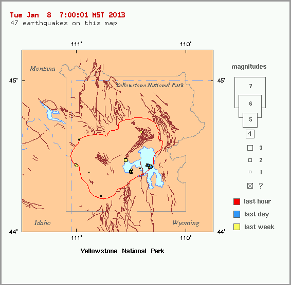
quote:1.2 2013/01/07 11:00:58 44.441N 110.346W 5.8 65 km (40 mi) ESE of West Yellowstone, MT
1.2 2013/01/07 11:00:58 44.431N 110.323W 10.6 67 km (42 mi) ESE of West Yellowstone, MT
-0.6 2013/01/07 02:15:44 44.437N 110.364W 2.6 64 km (40 mi) ESE of West Yellowstone, MT
2.1 2013/01/07 01:12:32 44.474N 110.553W 4.4 49 km (30 mi) ESE of West Yellowstone, MT
1.8 2013/01/07 01:12:22 44.480N 110.554W 2.0 48 km (30 mi) ESE of West Yellowstone, MT
0.8 2013/01/07 00:41:41 44.441N 110.354W 3.4 64 km (40 mi) ESE of West Yellowstone, MT
1.3 2013/01/07 00:26:45 44.437N 110.328W 5.9 67 km (41 mi) ESE of West Yellowstone, MT
0.5 2013/01/07 00:26:00 44.439N 110.354W 2.8 65 km (40 mi) ESE of West Yellowstone, MT
0.8 2013/01/07 00:19:35 44.432N 110.330W 7.9 67 km (41 mi) ESE of West Yellowstone, MT
2.0 2013/01/07 00:17:26 44.430N 110.332W 8.8 67 km (41 mi) ESE of West Yellowstone, MT
1.0 2013/01/07 00:11:47 44.442N 110.352W 3.2 65 km (40 mi) ESE of West Yellowstone, MT
0.2 2013/01/07 00:10:57 44.443N 110.355W 2.3 64 km (40 mi) ESE of West Yellowstone, MT
1.3 2013/01/07 00:09:01 44.437N 110.326W 11.1 67 km (41 mi) ESE of West Yellowstone, MT
1.1 2013/01/06 23:58:42 44.434N 110.324W 11.2 67 km (42 mi) ESE of West Yellowstone, MT
1.2 2013/01/06 23:56:01 44.436N 110.328W 11.5 67 km (41 mi) ESE of West Yellowstone, MT
1.0 2013/01/06 23:54:40 44.429N 110.317W 12.5 68 km (42 mi) ESE of West Yellowstone, MT
1.0 2013/01/06 23:49:05 44.428N 110.322W 10.6 67 km (42 mi) ESE of West Yellowstone, MT
0.9 2013/01/06 23:48:04 44.432N 110.320W 11.4 67 km (42 mi) ESE of West Yellowstone, MT
0.8 2013/01/06 23:46:44 44.442N 110.353W 1.5 64 km (40 mi) ESE of West Yellowstone, MT
1.3 2013/01/06 15:30:03 44.437N 110.341W 7.1 66 km (41 mi) ESE of West Yellowstone, MT
0.3 2013/01/06 08:08:49 44.394N 110.505W 3.5 56 km (35 mi) ESE of West Yellowstone, MT
0.9 2013/01/06 04:51:15 44.398N 110.509W 3.1 56 km (35 mi) ESE of West Yellowstone, MT
1.1 2013/01/06 04:18:56 44.399N 110.508W 2.4 56 km (35 mi) ESE of West Yellowstone, MT
0.9 2013/01/06 04:05:58 44.391N 110.502W 3.3 57 km (35 mi) ESE of West Yellowstone, MT
1.1 2013/01/06 03:31:14 44.396N 110.506W 2.2 56 km (35 mi) ESE of West Yellowstone, MT
0.8 2013/01/06 02:56:46 44.389N 110.495W 1.8 57 km (36 mi) ESE of West Yellowstone, MT
0.2 2013/01/06 02:45:30 44.398N 110.502W 2.0 56 km (35 mi) ESE of West Yellowstone, MT
0.9 2013/01/06 02:44:18 44.400N 110.502W 3.8 56 km (35 mi) ESE of West Yellowstone, MT
1.4 2013/01/06 00:37:18 44.392N 110.504W 3.6 56 km (35 mi) ESE of West Yellowstone, MT
1.0 2013/01/05 22:42:36 44.400N 110.504W 2.4 56 km (35 mi) ESE of West Yellowstone, MT
quote:Stoombootgeiser in Yellowstone voor het eerst sinds acht jaar weer actief
's Werelds hoogste geiser, de 'Stoombootgeiser' in Yellowstone Park in de Verenigde Staten, heeft woensdag weer eens gespoten. De laatste uitbarsting was alweer acht jaar geleden.
Het warme water van de geiser kwam gedurende bijna tien minuten 75 tot meer dan 90 meter hoog. De Stoomboot laat niet vaak van zich horen, er heeft wel eens 50 jaar tussen uitbarstingen gezeten.
In Yellowstone Park zijn meer geisers te vinden. Old Faithful, 'Ouwe Trouwe', is een stuk betrouwbaarder. Die geiser spuit eens om de 1,5 uur heet water de lucht in.
Een geiser ontstaat op plekken waar water verwarmd wordt door aardwarmte onder de grond. Als de omstandigheden goed zijn en de druk ver genoeg oploopt, kan een mengsel van water en stoom metershoog de lucht in spuiten'


quote:Earthquake Swarm Rocks Yellowstone
It was recently reported that a very rare triple swarm of earthquakes rocked Yellowstone National Park.
In fact, Bob Smith, a geophysics professor out of the University of Utah, says he has never seen even two swarms occur together before in all the 53 years that he has been monitoring seismic activity. Now, he he’s seen three.
An earthquake swarm, seismologists say, is an event where a sequence of earthquakes occurs in a limited geographic area over a short period of time.
Speaking about the event, Smith called it “remarkable,” asking, “How does one swarm relate to another? Can one swarm trigger another and vice versa?”
No answers are available to Smith’s questions, however, because simultaneous swarms haven’t been detected before.
Smith says he believes that at least two of the swarms are probably related to each other though.
The three swarms hit in the following areas: Lewis Lake, the Lower Geyser Basin and the northwest part of Norris Geyser Basin.
Earlier this month, on September 15, the largest earthquake to rock Yellowstone in over a year occurred about six miles north of the Old Faithful Geyser. Its magnitude was about 3.6 at its epicenter. It takes a magnitude of about 3.0 for people to feel it, a Yellowstone representative named Al Nash told the Jackson Hole News & Guide.
The recent swarms of earthquakes began on September 10 and finished up on September 16.
The University of Utah put out a statement saying that altogether 130 earthquakes with magnitudes ranging from 0.6 to 3.6 occurred in the area, with most of them being located in the Lower Geyser Basin. But, including many smaller events which were not detected, there were many more quakes than this.
The recent swarms produced four earthquakes which, although they were not large, were significant enough in size to be felt.
The first, which had a magnitude of 3.5, happened on September 13, about 17 miles northeast of West Yellowstone, Montana. The next two tremblors to be felt occurred early on the morning of September 15 with magnitudes of 3.2 and 3.4 respectively. These two occurred in rapid succession, with one being detected at 5:10 AM and the other at 5:11 AM. The quakes happened about 15 miles southeast of West Yellowstone. The largest earthquake recording during the swarm, a 3.6, was measured nearby about 4 1/2 hours later.
According to Nash, a strong enough earthquake, like the 7.3-7.5 quake that shook the Hebgen Lake area in 1959, has the potential to change the activity of the geysers in the area. And, in fact the 1959 quake did. It caused nearly 300 features to erupt, included 160 where there were no previous records of geysers. None of the current earthquakes were powerful enough to create these types of changes, however.
Smith says he believes that the current swarms of earthquakes may, in fact, be related to the 1959 earthquake. “We think that much of the seismicity is still aftershocks from that event in 1959. It can go on for hundreds of years.”
Usually only about half a dozen earthquakes occur each year in Yellowstone, Smith noted, so it is quite unusual for this level of swarm activity to rock the park.
quote:Yellowstone: Volcano vs Earthquake
YELLOWSTONE NATIONAL PARK -
Yellowstone National park is the largest super-volcano on the continent and possibly the world.
It's an underground boiling cauldron of lava, but just how likely is it to erupt or do scientists have other concerns?
"It's been 640,000 since the last eruption," says Jake Lowenstern, a scientist with the Yellowstone Volcano Observatory.
The lava pool beneath Yellowstone National Park is more than twice as big as scientists previously believed, that's according to new research from the Geological Society of America.
Scientists from the University of Utah say the lake of molten lava is nearly 50 miles long and 12 miles wide.
Jake Lowenstern, a scientist with the Yellowstone Volcano Observatory, says even a small eruption could cause a minor disaster.
"It could cause damage to the rivers, some flooding, it's going to put some ash into the air and the ash could certainly get out to the communities out here."
The park is known for the lava lake that fuels all the hot springs.
Scientists don't think the super-volcano will erupt, but the real risk to the region comes from earthquakes.
"There's going to be more earthquakes, the ground is going to move more and molten rock can't move up into this geyser system without causing explosions."
Researchers analyzed, get this, 4,500 earthquakes in and around Yellowstone from 1985 to 2013.
Scientists say the likelihood of a major quake greater than magnitude 7 is just over a tenth of a percent which is a thousand times more likely to happen then a super eruption.
"We do have the Geyser system at Yellowstone can be unstable at time and it can hurl rocks and throw them out ... We get earthquake swarms. We have the ground moving up and down at Yellowstone."
The last major earthquake in the area measured 7.3 and was in 1959. It was the most destructive earthquake ever recorded in the Rocky Mountains.
"If you look at the time scale of Yellowstone, it has been active a couple million years, it has these things semi-regularly. There will be events again, but you might have to wait another 10,000 years before it happens."
Just in the last week, there have been 25 earthquakes in the park area according to geologists. The good news, the biggest one registered only 2.9.
e supervulkaan die onder Yellowstone National Park sluimert, is volgens wetenschappers veel groter dan tot nu toe werd aangenomen.
Het park met de fotogenieke geisers in de Amerikaanse staat Wyoming herbergt een krater, de caldera, die elke 600.000 jaar tot uitbarsting komt. Uit seismologisch onderzoek is naar voor gekomen dat een mogelijke eruptie veel uitgebreider zal zijn dan eerst werd gevreesd.
Zo blijken de magmakamer en de hoeveelheid superheet gesmolten gesteente twee keer zo groot dan eerdere schattingen uitwezen. De holte onder het park heeft een lengte van bijna 90 kilometer en bereikt dieptes tot 15 kilometer onder het aardoppervlak.
Een uitbarsting van zo'n supervulkaan zou het hele klimaat op aarde kunnen beïnvloeden. De planeet zal jarenlang in een deken van vulkanische as gehuld worden, wat zal leiden tot een ijstijd.
Wanneer de supervulkaan opnieuw uitbarst, is koffiedik kijken. We kennen alleen de data uit het verleden. Yellowstone veroorzaakte al zeker drie keer eerder een supereruptie: 2,1 miljoen jaar, 1,3 miljoen jaar en 640.000 jaar geleden.
Dat zouden wij mee kunnen gaan maken dus
Never Stop Exploring!
Life begins at the end of your comfort zone!
Follow me on Twitter: https://twitter.com/EdwinKr83 Instagram: https://www.instagram.com/edwinkr83/
Life begins at the end of your comfort zone!
Follow me on Twitter: https://twitter.com/EdwinKr83 Instagram: https://www.instagram.com/edwinkr83/
Ze is over tijd.
Leuk, baby vulkaantjes.
Leuk, baby vulkaantjes.
Knapen die storneren willen moeten mannen met automatische incasso's zijn
Eigenlijk vroeg ik me af waarom ze er van uit gingen dat eerdere metingen niet nauwkeurig waren…quote:Zo blijken de magmakamer en de hoeveelheid superheet gesmolten gesteente twee keer zo groot dan eerdere schattingen uitwezen. De holte onder het park heeft een lengte van bijna 90 kilometer en bereikt dieptes tot 15 kilometer onder het aardoppervlak.
Er van uit gaande dat ze destijds ook nauwkeurig waren, kan het natuurlijk ook zijn dat de magmakamer sinds de laatste meting 2 keer zo groot is geworden.
Tussen de 1e en 2e uitbarsting zat 800.000 jaar tussen de 2e en derde zat 660.000 jaar.
De laatste is 640.000 jaar geleden.
Dus sowieso nog 20.000 jaar wachten. En stel dat we er van uitgaan dat het niet langer duurt dan de tijd tussen 1e en 2e uitbarsting, kunnen we dus nog maximaal 160.000 jaar wachten.
70/160.000 * 100% = 0.044% kans dat je hem mee maakt
Weinig kans dus.
Edit: voor een heel mensenleven dus, waar jij al een beetje van op gebruikt hebt.
De laatste is 640.000 jaar geleden.
Dus sowieso nog 20.000 jaar wachten. En stel dat we er van uitgaan dat het niet langer duurt dan de tijd tussen 1e en 2e uitbarsting, kunnen we dus nog maximaal 160.000 jaar wachten.
gemiddeld mensen leven: 70 jaar.quote:
Dat zouden wij mee kunnen gaan maken dus
70/160.000 * 100% = 0.044% kans dat je hem mee maakt
Weinig kans dus.
Edit: voor een heel mensenleven dus, waar jij al een beetje van op gebruikt hebt.
Altijd maar dat doemdenken over Yellowstone. 
Als ie barst dan barst ie, niemand weet wanneer hij zal barsten, dus waarom is er altijd zoveel gedoe over?
Als ie barst dan barst ie, niemand weet wanneer hij zal barsten, dus waarom is er altijd zoveel gedoe over?
Ach, dan is het wel meteen klaar voor een heleboel mensen op aarde.quote:
Dat zouden wij mee kunnen gaan maken dus
stupidity has become as common as common sense was before
En als alle ogen op Yellowstone gericht zijn barst er ergens anders op de aardkloot een supervulkaan uit die misschien nog nieteens ontdekt was. Ze schijnen zich ook onder oceanen te bevinden.quote:
Altijd maar dat doemdenken over Yellowstone.
Als ie barst dan barst ie, niemand weet wanneer hij zal barsten, dus waarom is er altijd zoveel gedoe over?
En in de waddenzee!quote:
[..]
En als alle ogen op Yellowstone gericht zijn barst er ergens anders op de aardkloot een supervulkaan uit die misschien nog nieteens ontdekt was. Ze schijnen zich ook onder oceanen te bevinden.
De Zuidwalvulkaan was een gewone stratovulkaan die voor het laatst actief was 120 miljoen jaar geleden. Er is geen magmatoevoer meer daar. Die vulkaan is dus duidelijk dood.
PVDA-PTB lid. Sanders supporter. Student psychologie. Interesse voor films, sport, geschiedenis, multimedia, wereldpolitiek, geologie en het weer.
Voor mij ligt de Laacher See vulkaan in Duitsland net zo ver weg (of dichtbij) en die boert nog regelmatig wat CO2 op,quote:
De Zuidwalvulkaan was een gewone stratovulkaan die voor het laatst actief was 120 miljoen jaar geleden. Er is geen magmatoevoer meer daar. Die vulkaan is dus duidelijk dood.
*kutkick*
Vanwege: 'Supervulkaan roeit hele mensheid uit'
en de bronverwijzing: http://www.dailystar.co.u(...)uld-erupt-ANY-SECOND

Vanwege: 'Supervulkaan roeit hele mensheid uit'
en de bronverwijzing: http://www.dailystar.co.u(...)uld-erupt-ANY-SECOND
quote:Experts are now creating plans to deal with a sudden blast but scientists predict that the eruption is likely happen in the next ten years.
Ach, doemdenkerij. Ik geloof best dat daar een supervulkaan zit die een vulkanische winter kan veroorzaken, maar dat gaat echt niet binnen nu en tien jaar gebeuren.quote:
*kutkick*
Vanwege: 'Supervulkaan roeit hele mensheid uit'
en de bronverwijzing: http://www.dailystar.co.u(...)uld-erupt-ANY-SECOND
[..]
Mjah... en sowieso richten ze zich te veel op Yellowstone omdat daar wat meer van bekend is, maar elders in de wereld zullen misschien ook nog grote magmakamers op springen staan.
Het is gewoon een kwestie van afwachten en dat duurt meestal langer dan een mensenleven.
Het is gewoon een kwestie van afwachten en dat duurt meestal langer dan een mensenleven.
Nou, zo'n -12,33 graden pak hem beet.quote:
Hoe koud wordt het dan zo'n beetje, als er een ijstijd komt?

No Yellowstone will not erupt within the next ten years...
quote:A major step to predicting when supervolcanoes will explode
Scientists have learned that massive caldera volcanoes, like the one stewing beneath Yellowstone, are ruled by geological processes far different than the ones governing conventional volcanoes. These massive reservoirs of magma can explode spontaneously — an important piece of insight that can help us predict a future disaster.
Super-eruptions are extremely rare, occurring once every 100,000 years or so. Disturbingly, these cataclysmic geological events aren't archaic phenomena; we know of at least 20 supervolcanoes on Earth, including Yellowstone, Lake Toba in Indonesia, Lake Taupo in New Zealand, and the Phlegraean Fields in Italy. Scientists say it'll only be a matter of time before the next Big One — an event that could eject upwards of 1,000 cubic kilometers of ash into the sky.
maller volcanoes, like Mt. Pinatubo, are typically triggered by earthquakes or other external factors; they're powered as magma shoots into the volcanic chamber, increasing internal pressure to the point when an explosion occurs. But supervolcanoes, which consist of massive reservoirs of magma deep beneath the surface, are ruled by considerably different processes.
A recent study conducted by a Swiss team from ETH Zurich now shows that the mechanism behind these eruptions is buoyant magma — the same force that makes it difficult to hold a basketball underwater. To reach this conclusion, the researchers simulated the intense pressure of heat in the caldera of a supervolcano by using an experimental station called a high pressure beamline. They filled synthetic magma into a diamond capsule and shot high-energy X-rays inside to monitor changes as the mixture reached critically high pressures. By doing so, they could calculate the amount of pressure required to induce a spontaneous eruption (their samples reached pressures of up to 36,000 atmospheres and temperatures of nearly 1,700°C — similar to the conditions inside a magma chamber).
Results showed that the mounting pressure caused by magma buoyancy can crack more than 6 miles (10 km) of the Earth's crust above the volcano chamber. Eventually, the magma penetrating these cracks will reach the Earth's surface. But as it rises, it expands violently, causing a tremendous explosion. Discouragingly, this research shows that supervolcanic eruptions could happen 10 to 100 times more often than previously assumed.
The good news — such that it is — is that we will be able to see this disaster coming, particularly at Yellowstone. Speaking to the BBC, geologist Wim Malfait said the ground would probably rise hundreds of meters. He believes that Yellowstone currently has 10-30% partial melt, and that the overpressure required for an eruption requires at least 50%. What's more, it can take hundreds of millions of years for this buoyancy force to create the pressure required for an explosion. It doesn't appear that Yellowstone is going to blow any time soon. But given this new insight, geologists can now start to monitor the conditions within this and other calderas in hopes of predicting a future eruption.
Met alle tegenstrijdige berichten kunnen we eigenlijk alleen maar afwachten en hopen dat het nog ver weg is.quote:Op dinsdag 7 januari 2014 11:22 schreef Frutsel het volgende:
No Yellowstone will not erupt within the next ten years...
[..]
In een ander artikel staat toch dat yellowston om de 600.000 jaar uitgebarsten is, dit is compleet in tegenspraak met de 100 miljoenen jaren voor de theoretische drukopbouw.quote:
No Yellowstone will not erupt within the next ten years...
[..]
What's more, it can take hundreds of millions of years for this buoyancy force to create the pressure required for an explosion. It doesn't appear that Yellowstone is going to blow any time soon
Dat is gemiddeld. Dus de kans dat ie nog uitbarst in ons leven is heel klein. Dus hoeraquote:
[..]
In een ander artikel staat toch dat yellowston om de 600.000 jaar uitgebarsten is, dit is compleet in tegenspraak met de 100 miljoenen jaren voor de theoretische drukopbouw.
'Richolio _O_' - tong80
LAST.FM
LAST.FM
Dat is gelukkig niet zo heel koud. Tijd om mijn herfstjas uit de kast te pakkenquote:
[..]
Nou, zo'n -12,33 graden pak hem beet.
'Richolio _O_' - tong80
LAST.FM
LAST.FM
quote:Op dinsdag 7 januari 2014 18:26 schreef richolio het volgende:
[..]
Dat is gemiddeld. Dus de kans dat ie nog uitbarst in ons leven is heel klein. Dus hoera
Die 100 miljoenen jaren voor de magma opbouw lijken me zo onwaarschijnlijk lang. 100 miljoen jaar geleden zaten we nog niet eens in het krijt tijdperk en zat noordamerika nog zo goed als vast aan europa.quote:
[..]
Dat is gemiddeld. Dus de kans dat ie nog uitbarst in ons leven is heel klein. Dus hoera
quote:4.8 quake strikes Northern Yellowstone Park
A 4.8 earthquake shook the northern part of Yellowstone National Park early Sunday.
The University of Utah Seismograph Stations reports the earthquake occurred at 6:34 a.m. about 4 miles north-northeast of the Norris Geyser Basin. The university reports it was felt in the Montana border towns of West Yellowstone and Gardiner, both about 20 miles from the epicenter.
There were no immediate reports of damage. There are few visitors in the park this time of year.
Yellowstone sees frequent small earthquakes. Since Thursday, there have been at least 25 recorded in the nation's first national park.
[ Bericht 5% gewijzigd door Frutsel op 01-05-2014 16:37:55 ]

quote:
http://www.inquisitr.com/(...)ping-the-park-video/
Niburu.co duikt er ook bovenop:
http://niburu.co/index.ph(...)=37:wereld&Itemid=50 (gerelateerd)
en
http://niburu.co/index.ph(...)=37:wereld&Itemid=50 (over yellowstone)
http://niburu.co/index.ph(...)=37:wereld&Itemid=50 (gerelateerd)
en
http://niburu.co/index.ph(...)=37:wereld&Itemid=50 (over yellowstone)
Dank voor de link, leuke sitequote:
Niburu.co duikt er ook bovenop:
http://niburu.co/index.ph(...)=37:wereld&Itemid=50 (gerelateerd)
en
http://niburu.co/index.ph(...)=37:wereld&Itemid=50 (over yellowstone)
Je hebt ook nog http://www.niburu.nl. Ooit was het één site, maar blijkbaar zijn de hosters op eigen houtje verder gegaan met ieder hun eigen site, vandaar dat er nou ook http://www.niburu.co is.quote:

Wederom bedankt, ik kom de avond wel door zo.quote:
[..]
Je hebt ook nog http://www.niburu.nl. Ooit was het één site, maar blijkbaar zijn de hosters op eigen houtje verder gegaan met ieder hun eigen site, vandaar dat er nou ook http://www.niburu.co is.
is de uplifting nou erger geworden de afgelopen jaren?
"I wear the mask to protect the city… but the city is what made the mask." – Batman
Situatie Yellowstone lijkt steeds kritischer
Donderdag, 10 juli 2014 12:11
De grond onder het Yellowstone Park stijgt in een alarmerend tempo, het water in het Yellowstone meer klotst als in een badkuip.
Metingen hebben nu aangetoond dat er grote hoeveelheden van bepaalde gassen vrijkomen, iets waar ook sprake van was bij andere grote vulkanen net voor een uitbarsting.
We weten dat de hele wereld in beroering is en dat we een periode van aardveranderingen meemaken. Het bewijst dat er “iets” is dat de aarde letterlijk aan alle kanten doet schudden en beven.
Overal ter wereld barsten vulkanen uit waarbij we onlangs de bizarre situatie hadden dat er zeven vulkanen binnen enkele uren tot uitbarsting kwamen.
Met de hele aarde in beroering is het eigenlijk logisch te noemen dat ook de beroemde Yellowstone Supervulkaan ineens tekenen van leven vertoont.
Zo hadden we eerder dit jaar een aardbeving in het park en zal Amerika ook niet voor niets haar nucleaire wapens weghalen uit de buurt van Yellowstone, zoals wij eerder schreven.
Veel mensen volgen daarom nauwgezet de ontwikkelingen rondom Yellowstone, waaronder een aantal lezers, van wie één het volgende schreef (dank!):
“Al geruime tijd volg ik het wel en wee van het Nat. Park Yellowstone.
Een aantal zaken zijn opvallend. Er is veel beweging , m.n. aardschokken en grond verhoging.
Nu is dat niet onnatuurlijk, alleen de frequentie waarmee dit nu plaatsvindt is op zijn minst zorgwekkend te noemen.
De Amerikaanse USGS doet alsof er niks aan de hand is en "vergeet" de meeste bevingen zelfs maar te vermelden. De bewoners in dit gebied wat zich uitstrekt over tenminste 3 staten, proberen nu massaal hun huizen te verkopen. Rara waarom zou dat zijn ?
De dieren in het Park worden vaker dan ooit aangereden en gedood , door o.a. mysterieuze reden...
De afgelopen maand heeft een Russisch onderzoeksteam, het Amerikaanse luchtruim geschonden door metingen te verrichten op afwijkingen in de magnetosfeer boven Alaska en Yellowstone. Dit n.a.v. een alarm signaal van een van hun satelieten.
Dit rapport is ook ter beschikking gesteld van de Amerikaanse regering die er vervolgens niks mee doet, zodat het in arremoede maar op You Tube is gezet.
Dit is inmiddels de 2de bij mij bekende waarschuwing van Rusland naar Amerika m.b.t. Yellowstone. Dit is van belang omdat een eruptie al "over tijd " is en wij hier niet ongeschonden uit zullen komen”.
De volgende korte video geeft een goede samenvatting van de huidige situatie:
De laatste dagen is er een groeiend aantal alarmerende berichten uit het Yellowstone gebied.
Omdat er in Amerika nogal wat verzwegen wordt door de officiële instanties en de media zijn een aantal mensen met meetapparatuur zelf op onderzoek uit gegaan.
Zoals je kunt horen in de onderstaande video hebben die een aantal zaken geconstateerd waar je niet echt vrolijk van wordt.
Als je als bezoeker van het Park kijkt naar het water van het Yellowstone Meer dan zul je niets bijzonders ontdekken. Als je echter meetapparatuur gebruikt dan constateer je dat het water in het meer heen en weer klotst, net zoals in een badkuip. Alsof iets het meer heen en weer schudt.
Waar ze vooral van geschrokken zijn, is de hoeveelheid van bepaalde gassen die nu vrijkomen. Nu is dit altijd eigenlijk al het geval geweest, maar het soort gas dat nu vrijkomt in aanzienlijke hoeveelheden zoals waterstofsulfide en zwaveldioxide komen vaak vrij bij vulkanen net voordat ze tot uitbarsting komen.
Dat het rommelt in en rondom Yellowstone is duidelijk. Jammergenoeg kan niemand precies voorspellen wanneer deze gigant werkelijk tot uitbarsting zal komen.
---------------------------------------------------------------
Donderdag, 10 juli 2014 12:11
De grond onder het Yellowstone Park stijgt in een alarmerend tempo, het water in het Yellowstone meer klotst als in een badkuip.
Metingen hebben nu aangetoond dat er grote hoeveelheden van bepaalde gassen vrijkomen, iets waar ook sprake van was bij andere grote vulkanen net voor een uitbarsting.
We weten dat de hele wereld in beroering is en dat we een periode van aardveranderingen meemaken. Het bewijst dat er “iets” is dat de aarde letterlijk aan alle kanten doet schudden en beven.
Overal ter wereld barsten vulkanen uit waarbij we onlangs de bizarre situatie hadden dat er zeven vulkanen binnen enkele uren tot uitbarsting kwamen.
Met de hele aarde in beroering is het eigenlijk logisch te noemen dat ook de beroemde Yellowstone Supervulkaan ineens tekenen van leven vertoont.
Zo hadden we eerder dit jaar een aardbeving in het park en zal Amerika ook niet voor niets haar nucleaire wapens weghalen uit de buurt van Yellowstone, zoals wij eerder schreven.
Veel mensen volgen daarom nauwgezet de ontwikkelingen rondom Yellowstone, waaronder een aantal lezers, van wie één het volgende schreef (dank!):
“Al geruime tijd volg ik het wel en wee van het Nat. Park Yellowstone.
Een aantal zaken zijn opvallend. Er is veel beweging , m.n. aardschokken en grond verhoging.
Nu is dat niet onnatuurlijk, alleen de frequentie waarmee dit nu plaatsvindt is op zijn minst zorgwekkend te noemen.
De Amerikaanse USGS doet alsof er niks aan de hand is en "vergeet" de meeste bevingen zelfs maar te vermelden. De bewoners in dit gebied wat zich uitstrekt over tenminste 3 staten, proberen nu massaal hun huizen te verkopen. Rara waarom zou dat zijn ?
De dieren in het Park worden vaker dan ooit aangereden en gedood , door o.a. mysterieuze reden...
De afgelopen maand heeft een Russisch onderzoeksteam, het Amerikaanse luchtruim geschonden door metingen te verrichten op afwijkingen in de magnetosfeer boven Alaska en Yellowstone. Dit n.a.v. een alarm signaal van een van hun satelieten.
Dit rapport is ook ter beschikking gesteld van de Amerikaanse regering die er vervolgens niks mee doet, zodat het in arremoede maar op You Tube is gezet.
Dit is inmiddels de 2de bij mij bekende waarschuwing van Rusland naar Amerika m.b.t. Yellowstone. Dit is van belang omdat een eruptie al "over tijd " is en wij hier niet ongeschonden uit zullen komen”.
De volgende korte video geeft een goede samenvatting van de huidige situatie:

De laatste dagen is er een groeiend aantal alarmerende berichten uit het Yellowstone gebied.
Omdat er in Amerika nogal wat verzwegen wordt door de officiële instanties en de media zijn een aantal mensen met meetapparatuur zelf op onderzoek uit gegaan.
Zoals je kunt horen in de onderstaande video hebben die een aantal zaken geconstateerd waar je niet echt vrolijk van wordt.
Als je als bezoeker van het Park kijkt naar het water van het Yellowstone Meer dan zul je niets bijzonders ontdekken. Als je echter meetapparatuur gebruikt dan constateer je dat het water in het meer heen en weer klotst, net zoals in een badkuip. Alsof iets het meer heen en weer schudt.
Waar ze vooral van geschrokken zijn, is de hoeveelheid van bepaalde gassen die nu vrijkomen. Nu is dit altijd eigenlijk al het geval geweest, maar het soort gas dat nu vrijkomt in aanzienlijke hoeveelheden zoals waterstofsulfide en zwaveldioxide komen vaak vrij bij vulkanen net voordat ze tot uitbarsting komen.
Dat het rommelt in en rondom Yellowstone is duidelijk. Jammergenoeg kan niemand precies voorspellen wanneer deze gigant werkelijk tot uitbarsting zal komen.
---------------------------------------------------------------


Hoe verder ik in het bericht kom, hoe meer ik het een onzinbericht vind. Zeker uitgegeven door een hippie, pas als er een normaal bericht komt ga ik het serieus nemen...
100.000 katjes
Fuck the EBU!
Fuck the EBU!


Zal het nu dan eindelijk echt echt gebeuren of is het weer zo'n dooie mus situatie?
Iedereen is de hoofdrolspeler van zijn eigen komedie.
Vrijheid
Vrijheid
quote:Op vrijdag 11 juli 2014 14:56 schreef jogy het volgende:
Zal het nu dan eindelijk echt echt gebeuren of is het weer zo'n dooie mus situatie?
Alweer?
Acquisitie n.a.v. deze post wordt niet op prijs gesteld.
Don't you see going to heaven is just in the thought that you might?
As an on-line radio program grows longer, the probability of a German song approaches 1.
Don't you see going to heaven is just in the thought that you might?
As an on-line radio program grows longer, the probability of a German song approaches 1.
Dit. Vol goede moed lezen, hoe meer ik las, hoe meer ik dacht ''Wat is deze?quote:
Hoe verder ik in het bericht kom, hoe meer ik het een onzinbericht vind. Zeker uitgegeven door een hippie, pas als er een normaal bericht komt ga ik het serieus nemen...
Het komt dan ook van niburu.coquote:
Dit. Vol goede moed lezen, hoe meer ik las, hoe meer ik dacht ''Wat is deze?
Schopje TRU gaarne
Acquisitie n.a.v. deze post wordt niet op prijs gesteld.
Don't you see going to heaven is just in the thought that you might?
As an on-line radio program grows longer, the probability of a German song approaches 1.
Don't you see going to heaven is just in the thought that you might?
As an on-line radio program grows longer, the probability of a German song approaches 1.
Wel een goeie site, die bron. Je kan er ook UFO-waarnemingen doorgeven.quote:
Hoe verder ik in het bericht kom, hoe meer ik het een onzinbericht vind. Zeker uitgegeven door een hippie, pas als er een normaal bericht komt ga ik het serieus nemen...
Mooi toch
http://volcanoes.usgs.gov/activity/status.php. geeft niet veel bijzonders. Maar die zitten ook in het complot.
How do we turn this world-class fuck-up into a world-class learning experience?
Volkskrantquote:
[..]
Wel een goeie site, die bron. Je kan er ook UFO-waarnemingen doorgeven.
Mooi toch
http://volcanoes.usgs.gov/activity/status.php. geeft niet veel bijzonders. Maar die zitten ook in het complot.

Bijna een jaar oud manquote:
En volgens mij loopt dit gezeik al vanaf 2010 of zo. Elk jaar komt Yellowstone wel een keer apocalyptische verhalen zaaien in het nieuws en zakt het daarna weer lafjes weg.
Iedereen is de hoofdrolspeler van zijn eigen komedie.
Vrijheid
Vrijheid

Een generiek bericht uit 2013. Zegt helemaal niets over een direct gevaar ofzo. Kan je wel allemaal berichtjes gaan verzamelen maar een punt maken doe je niet. Ja Yellowstone is een gebied vol thermische activiteit maar wanneer en of er iets gaat gebeuren daar is hooguit op geologische schaal een beetje te gokken.quote:
[ Bericht 0% gewijzigd door Opa.Bakkebaard op 11-07-2014 17:09:39 ]
Als je er nog niet bent geweest: absoluut doen.
Dood ga je toch
Dood ga je toch
How do we turn this world-class fuck-up into a world-class learning experience?

zolang ons kleine nederlandje maar heel blijft en ik kan blijven fokken is het geen probleem
SOMEWHERE THERE IS A TREE, TIRELESSLY PRODUCING OXYGEN SO THAT YOU CAN STAY ALIVE. FIND IT AND APOLOGIZE.

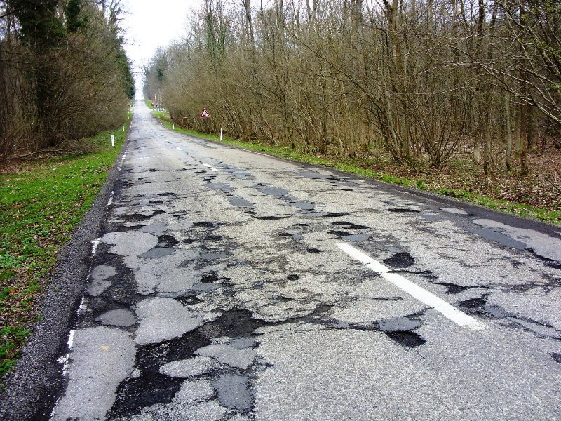
Die gaten in het asfalt! HET BEGINT!!! RUN!quote:
 Op
Op
Acquisitie n.a.v. deze post wordt niet op prijs gesteld.
Don't you see going to heaven is just in the thought that you might?
As an on-line radio program grows longer, the probability of a German song approaches 1.
Don't you see going to heaven is just in the thought that you might?
As an on-line radio program grows longer, the probability of a German song approaches 1.
Wat verwacht men dan precies dat de Amerikaanse overheid er aan doet, een wet opstellen die het voor vulkanen verbiedt om uit te barsten?quote:Dit rapport is ook ter beschikking gesteld van de Amerikaanse regering die er vervolgens niks mee doet

Probleem is met Yellowstone dat deze in theorie nogal wat wereldwijde heibel kan schoppen volgens mij. Als die knalt dan knalt de wereld meequote:Op vrijdag 11 juli 2014 15:30 schreef Basxt het volgende:
zolang ons kleine nederlandje maar heel blijft en ik kan blijven fokken is het geen probleem
Iedereen is de hoofdrolspeler van zijn eigen komedie.
Vrijheid
Vrijheid
Of eindelijk eens iets doen aan CO2 uitstoot?quote:
[..]
Wat verwacht men dan precies dat de Amerikaanse overheid er aan doet, een wet opstellen die het voor vulkanen verbiedt om uit te barsten?
How do we turn this world-class fuck-up into a world-class learning experience?
ken ik niet. denk ik.quote:Op vrijdag 11 juli 2014 15:44 schreef jogy het volgende:
[..]
Probleem is met Yellowstone dat deze in theorie nogal wat wereldwijde heibel kan schoppen volgens mij. Als die knalt dan knalt de wereld mee
en boeie
SOMEWHERE THERE IS A TREE, TIRELESSLY PRODUCING OXYGEN SO THAT YOU CAN STAY ALIVE. FIND IT AND APOLOGIZE.
quote:
[..]
Is dat bijzonder? gaten in het wegdek?
Foto's van het wegdek in bijv. België.
[ afbeelding ]
[ afbeelding ]
The Road (2009) - IMDbquote:
Alleen als je dicht in de buurt zit, de rest verhongerd/bevriest en gaat op die manier een stuk trager dood.quote:en boeie
Iedereen is de hoofdrolspeler van zijn eigen komedie.
Vrijheid
Vrijheid
De as en gevolgen binnen de grenzen van de VS houden natuurlijk.quote:
Wat verwacht men dan precies dat de Amerikaanse overheid er aan doet, een wet opstellen die het voor vulkanen verbiedt om uit te barsten?
Acquisitie n.a.v. deze post wordt niet op prijs gesteld.
Don't you see going to heaven is just in the thought that you might?
As an on-line radio program grows longer, the probability of a German song approaches 1.
Don't you see going to heaven is just in the thought that you might?
As an on-line radio program grows longer, the probability of a German song approaches 1.

Ziet er altijd vaag uit ja, maar niet ongewoon. Ik was in Indonesie in een vulkanisch gebied en daar had je gewoon diepe gaten in de natuur (niks geen hekjes oid) waar zwaveldamp uit kwam. Als je te dichtbij kwam ging je direct over je nek. Maar soms liep er een weg langs en dan zag je idd dit op de plek waar de damp vaak neersloeg.quote:
Vulkanische gebieden zijn mijn favoriete natuurplekjes. Er is altijd wel iets raars te zien. Borrelend modder, of knalgroene/gele/rode meren.
Opgeblazen gevoel of winderigheid? Zo opgelost met Rennie!
2012 niet gezien? Je wordt hooguit iets omver geblazen als Yellowstone naast je ontploft..quote:
[..]
Die gaten in het asfalt! HET BEGINT!!! RUN!
Is dit weer zo'n waarschuwing dat het in de 'nabije'toekomst plaats zal vinden?
Dit topic is niet geheel uit mijn handen... maar eerder van mijn broer.
Ik post zeg maar op zijn ingevingen (en nee hij is niet LTS-zwakstroom).
Daily mail
----
Hoe goed is jullie Zuid Afrikaans.
Die ANC-regering het ‘n versoek van die VSA van die hand gewys om deel te wees van ‘n Amerikaanse rampbestuursplan waaruit Suid-Afrika $10 miljard per jaar (ongeveer R100 miljard) vir tien jaar sou ontvang. Luidens die plan sou tydelike huisvesting vir miljoene Amerikaners in Suid-Afrika gebou word ingeval die Yellowstone-supervulkaan in dié land een of ander tyd tot uitbarsting sou kom.
Lande wat wel aan die Amerikaanse noodlenigingsplan gaan deelneem, is Brasilië, Argentinië en Australië. Volgens ‘n woordvoerder van die departement van buitelandse sake, dr. Sipho Matwetwe, sal Suid-Afrika nie “deel van die plan wees nie omdat daar ‘n risiko bestaan dat miljoene wit Amerikaners in ‘n noodsituasie na die land gestuur kan word en dit kan ons nasionale kultuur en identiteit bedreig”.
Amerikaanse wetenskaplikes hou reeds jare lank die supervulkaan onder die Yellowstone-nasionale park in die VSA dop. ‘n Supervulkaan is honderd keer so kragtig soos ‘n gewone vulkaan en kan nie net miljoene mense laat omkom nie, maar ook ‘n hele beskawing uitdelg. Indien Yellowstone sou uitbars, sou die hele Noord-Amerika verwoes word en die aarde mag enkele jare lank in ‘n “vulkaniese winter” gedompel word.
Die laaste bekende supervulkaniese uitbarsting het blykbaar ongeveer 70 000 jaar gelede plaasgevind langs die Toba-meer in Soematra, Indonesië. Dit het ‘n vulkaniese winter veroorsaak wat ses tot agt jaar geduur het, asook ‘n tydvak van aardverkoeling ingelui wat ‘n duisend jaar geduur het.
‘n Onlangse wetenskaplike ontleding van die gesmelte rots onder die Yellowstone-nasionale park in die Verenigde State van Amerika het onthul dat ‘n uitbarsting sonder enige eksterne invloed moontlik is.
Wetenskaplikes het voorheen geglo dat vele supervulkaniese uitbarstings eers deur ‘n aardbewing ontketen moet word om die aarde se kors oop te breek vir die magma om te ontsnap. Maar nuwe navorsing toon dat dit spontaan as gevolg van ‘n toename in druk kan plaasvind.
Supervulkane verteenwoordig die tweede grootste gevaar vir lewe op aarde, ná ‘n botsing van die aarde met asteroïdes, en hulle was in die verlede verantwoordelik vir massa-uitsterwings van spesies op aarde, langtermynklimaatsveranderings en korter “vulkaniese winters” wat veroorsaak word as vulkaniese as die sonlig afkeer.
Amerikaanse wetenskaplikes het Suid-Afrika geïdentifiseer as ‘n gebied waar mense sou kon oorleef tydens die vulkaniese winter wat Yellowstone sou veroorsaak. Hoewel die Amerikaanse regering geensins paniek onder sy burgers wil veroorsaak nie, is op ‘n “gebeurlikheidsplan” besluit indien die ergste wel sou plaasvind en Yellowstone tot uitbarsting kom.
Die vulkaan word tans deurentyd deur seismograwe by 45 punte gemonitor en waarskynlike sou die VSA oor enkele weke of dae se waarskuwing beskik om groot getalle van sy burgers oorsee en veral na die suidelike halfrond te stuur.
Kunstenaarsvoorstelling van Yellowstone wat uitbars
Yellowstone in die deelstaat Wyoming het 600 000 jare gelede ‘n uitbarsting beleef en meer as 1000 kubieke kilometer as en lawa in die atmosfeer ingestuur – omtrent 100 keer meer as die Berg Pinatubo-uitbarsting in die Filipyne in 1982, wat ‘n merkbare tydvak van globale verkoeling meegebring het.
Hoewel die Suid-Afrikaanse ministeries van buitelandse sake, asook wetenskap en tegnologie, volledig oor die Amerikaanse plan ingelig is, tesame met die groot bedrae geld wat betaal sou word om tydelike huisvesting vir Amerikaners in die Karoo en in die Kalahari op te rig waar hulle sou kon oorleef, het die kabinet besluit om die Amerikaanse versoek van die hand te wys.
Die R100 miljard sou van 2014 af elke jaar vir tien jaar aan Suid-Afrika betaal word, waarna die plan hersien sou word.
Dit kan tot tien jaar neem vir druk om in die magmakamer van die supervulkaan op te bou. Volgens dr. Jean-Philippe Perrillat van die Nasionale Sentrum vir Wetenskaplike Navorsing in Grenoble, Frankryk, “is dit die verskil in digtheid tussen die gesmelte magma in die kaldera en die omliggende rots wat groot genoeg is om die magma vanuit die kamer na die oppervlak te laat styg”.
“Die uitwerking is dieselfde as die ekstra dryfvermoë van ‘n sokkerbal wat onderwater met lug gevul word, waarna dit na die oppervlak styg omdat die omringende water digter is,” sê dr. Perrillat. “As die volume magma groot genoeg is, behoort dit na die oppervlak te styg en te ontplof soos ‘n sjampanjebottel wat ontkurk word.”
Volgens dr. Sipho Mathetwe, het die Suid-Afrikaanse regering “simpatie vir die Amerikaanse uitdaging (challenge) met Yellowstone, maar ons het ons eie uitdagings in Suid-Afrika. Daar is 200 miljoen witmense in Amerika en as te veel van hulle Suid-Afrika toe vlug, kan dit ‘n groot probleem veroorsaak, selfs al is daar genoeg huisvesting en infrastruktuur beskikbaar. Dit sal die land destabiliseer en kan selfs apartheid laat terugkom. Suid-Afrika is nie te koop nie.”
Die Amerikaanse ambassadeur in Pretoria was nie vir kommentaar beskikbaar nie.
-----
Goed genoeg om 1 April 2014 te spotten op die pagina.quote:
Dit topic is niet geheel uit mijn handen... maar eerder van mijn broer.
Ik post zeg maar op zijn ingevingen (en nee hij is niet LTS-zwakstroom).
...
----
Hoe goed is jullie Zuid Afrikaans?
...
[ Bericht 9% gewijzigd door Hyperdude op 12-07-2014 09:52:22 ]
How do we turn this world-class fuck-up into a world-class learning experience?
Waar zijn je researchskills gebleven drugshond? Een topic dat al vanaf 2005 loopt.
WKN / Supervulkaan Yellowstone #2
WKN / Supervulkaan Yellowstone #2
Vroeg ik me ook al af... en dan nog wel Niburu...quote:
Waar zijn je researchskills gebleven drugshond? Een topic dat al vanaf 2005 loopt.
WKN / Supervulkaan Yellowstone #2
Je kan beter Drugshond...
Oeh weer recente Yellowstone updates.
Dat de situatie dreigender lijkt te worden, wil niet zeggen dat het in het verleden (voor de eerste metingen) er al eerder zo uitgezien heeft. Die tientallen jaren dat de vulkaan in de gaten gehouden wordt, verbleekt natuurlijk tegen die ruim 600.000 jaar dat er niets gebeurd is. Of misschien zijn er in de tussentijd wel kleinschalige dingen gebeurd in Yellowstone park, maar zijn er geen waarnemingen van vastgelegd en is er niets van terug te vinden in de bodem. Sowieso liep er in een groot deel van die periode nog geen mens op het Amerikaanse continent.
[ Bericht 51% gewijzigd door DemonRage op 13-07-2014 12:29:17 ]
quote:How to keep things hot at Yellowstone and Katla: Just add water
Two volcanoes that get the interwebs all hot and bothered have made the news in the last week. First, Katla in Iceland produced some glacial flooding (jökulhlaups) that followed some earthquakes. Second, over at everyone’s favorite caldera, Yellowstone, there has been a lot of buzz over roads melting due to heat from the volcano. Now, as odd as it might seem, these two events are connected by the same process: geothermal (and hydrothermal) activity. When it comes down to it, most volcanoes are sitting on big heat sources. One way to lose the heat is by erupting, but probably the most important way to lose the heat is by the circulation of water in the crust. This water help keep things hot by efficiently moving heat generated by the magma that might be 5-6 kilometers (or more) below the surface and bringing it up to the surface — all of this happening when there is no threat of an eruption.
When you examine the history of a volcano, you’ll quickly see it spends much of its existence not erupting. However, during those periods of quiet between eruptions, there is plenty going on beneath the volcano. The magma is cooling and releasing heat and fluids in the surrounding rocks, causing the development of a hydrothermal system above the cooling magma. This is usually the top 5 kilometers of crust above the magma, where cracks in the rocks can help hot fluids rise from the magma and cool fluids (like rainwater or snowmelt) percolate down into the crust and heat up. So, how hot does it get under a volcano? Well, by examining the exposed innards of extinct volcanoes, we can see how much alteration the rocks and minerals have experienced. This is an important step in understand how certain valuable ore deposits, like porphyry copper, form above bodies of magma under volcanoes.
Looking at these zones of hydrothermal alteration, it is clear that the subsurface temperatures get hot — upwards of 300-500°C even multiple kilometers above any cooling magma body. Now, that heat isn’t getting there by conduction alone. Rock isn’t a very good conductor, so heat won’t travel far. However, if you heat up water traveling through cracks in the rock, you can transport a lot of heat upwards. That’s because water has a high heat capacity – think about how the Gulf Stream brings warm water from the tropics to the North Atlantic to keep Europe warm. That is what allows all the alteration to occur and for hydrothermal systems to form. These hydrothermal systems are constantly changing based on the seasons (thanks to changing access to water percolating into the crust), seismicity that opens and closes cracks and yes, even magma moving. However, most of the time, the changes in the system are merely due to new routes these hot fluids take to reach the surface.
What are the manifestations of these hydrothermal fluids? You see some of them at most active volcanoes: steam vents (fumaroles), hot springs, geysers, mud pots. Each is a different way heat escapes the ground. Steam vents tend to be the hottest, releasing steam (with other volcanic gases) at temperatures of 300-500°C. Geysers are explosions of superheated water, so they will be ~100°C. Hot springs and mud pots tend to be much cooler, with temperatures usually 20-70°C, depending of the vigor of the spring or geyser.
Glacial flooding from underneath Mýrdalsjökull in Iceland, seen at Múlakvísl. Photo by the Icelandic Met Office.
Glacial flooding from underneath Mýrdalsjökull in Iceland, seen at Múlakvísl. Photo by the Icelandic Met Office.
So, even moving water through the crust can bring a lot of heat upwards and that is common at most volcanoes — as are changes in the hydrothermal system over time. So, what is happening at Katla and Yellowstone?First, at Katla, the hydrothermal system works underneath a large ice cap (Mýrdalsjökull). Especially during warmer months, more water can percolate into the crust, causing changes in the hydrothermal system (which, by itself, can generate earthquakes). If more heated water and steam is allowed to reach the surface, then more ice can melt and pond until it is catastrophically released as a flood. Reports from the Iceland Met Office support this idea – the waters are warm as they come out from under the glacier. However, unlike an eruption-driven event, the melting isn’t accompanied by a continuously increasing number of earthquakes that would betray magma moving. So, the most likely explanation for these floods is increasing melting due to changes in the hydrothermal (geothermal) system, not an eruption. These sorts of floods have happened before during this time of year at Katla, sometimes more dramatic than others.
Now, at Yellowstone, we have a different manifestation of the same thing. The news has splashed images of melting roads on Firehole Lake Drive in an area with intense hydrothermal activity. The usual suspects (e.g., the Yellowstone disaster groupies) want to say this is evidence that an eruption is in the works. Well, again, sorry to disappoint the lunatic fringe, but it isn’t. Instead, this is a sign that the hydrothermal system under Firehole Lake Drive has shifted some — maybe due to the constant seismicity that gently shakes Yellowstone, maybe due to the water table, maybe even due to the road itself — and now heat is coming up directly under the road. Now, asphalt like that can melt at temperatures as low at ~50-70°C, so well within the range of most hydrothermal features. Measures of the road surface by NPS workers are ~70°C, so we’re well within the range of temperatures needed to melt the road. Just move where that hot spring or fumarole is coming up and boom, you have heat under the road, melting it.
07-08-2014
Breaking: Yellowstone Geëvacueerd: Experts beweren dat ‘Super Vulkaan’ binnen enkele weken kan uitbarsten!
Yellowstone National Park is haastig geëvacueerd uit angst voor een uitbarsting van de supervulkaan Yellowstone Caldera. Deze uitbarsting wordt geacht veel sneller dan eerder werd verwacht te naderen. Onderzoekers op dit terrein beweren dat de 640.000 jaar oude supervulkaan een plotselinge piek van activiteit aangeeft waaruit kan worden afgeleid dat deze zou kunnen gaan uitbarsten in slechts twee weken. Een explosie veroorzaakt door de vulkaan vrijwel de gehele Verenigde Staten in een 200 jaar lange vulkanische winter, storten en met as het zonlicht uitwissen . Hierdoor zou de pyroclastische STROOM onherstelbaar beschadigd raken evenals het omringende ecosysteem.
Twee weken geleden werden een aantal wegen gesloten nadat het asfalt begon te smelten en er scheuren ontstonden vanwege de extreme temperaturen onder het aardoppervlak. Niemand heeft nog kunnen lokaliseren wat deze plotselinge stijging heeft veroorzaakt. Experts houden toezicht op de vulkaan en zijn vooral bezig met het weghouden nieuwsgierigen uit het park, evenals het VEILIG ontruimen en evacueren van omliggende gebieden om eventuele ongevallen te voorkomen.
De wetenschappelijke gemeenschap is verdeeld over wanneer de vulkaan precies zal uitbarsten. Sommigen zeggen weken, terwijl andere kampen suggereren dat het een kwestie van maanden zou kunnen zijn. Over een ding zijn ze het echter allemaal eens, en dat is dat het zeer, zeer binnenkort zal gebeuren. Senior Vulkanoloog Richard Dunn gaf het volgende verslag met betrekking tot de alarmerende activiteit van de vulkaan. “Dit is iets wat nog nooit eerder is gebeurd. Deze onvoorspelbare flux van de activiteit is zeer zorgwekkend, en gaat lijnrecht in tegen al onze eerdere studies met betrekking tot deze bijzondere vulkaan. Onze voornaamste zorg op dit moment is om mensen in veiligheid te brengen. ”
http://worldunity.me/brea(...)le-weken-uitbarsten/
Breaking: Yellowstone Geëvacueerd: Experts beweren dat ‘Super Vulkaan’ binnen enkele weken kan uitbarsten!
Yellowstone National Park is haastig geëvacueerd uit angst voor een uitbarsting van de supervulkaan Yellowstone Caldera. Deze uitbarsting wordt geacht veel sneller dan eerder werd verwacht te naderen. Onderzoekers op dit terrein beweren dat de 640.000 jaar oude supervulkaan een plotselinge piek van activiteit aangeeft waaruit kan worden afgeleid dat deze zou kunnen gaan uitbarsten in slechts twee weken. Een explosie veroorzaakt door de vulkaan vrijwel de gehele Verenigde Staten in een 200 jaar lange vulkanische winter, storten en met as het zonlicht uitwissen . Hierdoor zou de pyroclastische STROOM onherstelbaar beschadigd raken evenals het omringende ecosysteem.
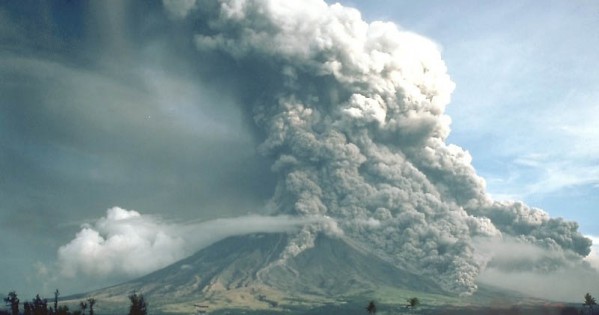
Twee weken geleden werden een aantal wegen gesloten nadat het asfalt begon te smelten en er scheuren ontstonden vanwege de extreme temperaturen onder het aardoppervlak. Niemand heeft nog kunnen lokaliseren wat deze plotselinge stijging heeft veroorzaakt. Experts houden toezicht op de vulkaan en zijn vooral bezig met het weghouden nieuwsgierigen uit het park, evenals het VEILIG ontruimen en evacueren van omliggende gebieden om eventuele ongevallen te voorkomen.
De wetenschappelijke gemeenschap is verdeeld over wanneer de vulkaan precies zal uitbarsten. Sommigen zeggen weken, terwijl andere kampen suggereren dat het een kwestie van maanden zou kunnen zijn. Over een ding zijn ze het echter allemaal eens, en dat is dat het zeer, zeer binnenkort zal gebeuren. Senior Vulkanoloog Richard Dunn gaf het volgende verslag met betrekking tot de alarmerende activiteit van de vulkaan. “Dit is iets wat nog nooit eerder is gebeurd. Deze onvoorspelbare flux van de activiteit is zeer zorgwekkend, en gaat lijnrecht in tegen al onze eerdere studies met betrekking tot deze bijzondere vulkaan. Onze voornaamste zorg op dit moment is om mensen in veiligheid te brengen. ”
http://worldunity.me/brea(...)le-weken-uitbarsten/
Death Makes Angels of us all
And gives us wings where we had shoulders
Smooth as raven' s claws...
And gives us wings where we had shoulders
Smooth as raven' s claws...
makkelijk vertaald uit de bron
http://civictribune.com/yellowstone-evacuated-experts-claim-super-volcano-erupt-within-weeks/
dit bericht is van 3 augustus en de commentaren zijn beter dan het artikel zelf.
http://civictribune.com/yellowstone-evacuated-experts-claim-super-volcano-erupt-within-weeks/
dit bericht is van 3 augustus en de commentaren zijn beter dan het artikel zelf.
Bij Hoevelaken linksaf
De commentaren gaan voornamelijk over god en dat het goed gaat komen met de geloofsgekkie'squote:
makkelijk vertaald uit de bron
http://civictribune.com/yellowstone-evacuated-experts-claim-super-volcano-erupt-within-weeks/
dit bericht is van 3 augustus en de commentaren zijn beter dan het artikel zelf.
08-08-2014
Is The Yellowstone Supervolcano About To Erupt?
The internet is both a blessing and a curse. It provides us with endless information on any topic you could dream of at just the click of a button. On the flip side, it’s full of crap that’s easy to believe if you don’t spend the time looking for credible sources to back up what is being said. One such example is the Yellowstone supervolcano. Rumors often surface that it is about to erupt, and they’re doing the rounds once again. So, what’s the crack with this colossal caldera? Is it about to shoot its load and wipe out millions of people? Let’s take a look.
Yellowstone National Park is home to a huge caldera (bowl-shaped feature that resulted from the collapse of land after a volcanic eruption) and supervolcano that are collectively known as the Yellowstone Caldera. A recent study discovered that the volcano has a gargantuan magma chamber measuring 90 km in length and up to 17 km in depth in some areas, which was more than double previous estimates. However, according to experts, the updated size does not increase the volcanic hazard in the Yellowstone region.
Scientists believe that three super-eruptions have occurred in the past on a 600,000-700,000 year cycle, starting around 2.1 million years ago. The last huge eruption is thought to have occurred around 640,000 years ago, but that doesn’t necessarily mean we’re in the firing line right now. At the same time, scientists are very aware of the implications of such an eruption. Consequently, the US Geological Survey (USGS) Volcanic Hazards Program keeps a watchful eye on this beast and is constantly recording its activity via seismometers and other bits of monitoring equipment.
It is not a quiet volcano- hot fluids are constantly yo-yoing through the crust, resulting in frequent earthquakes. Indeed, just last month 99 earthquakes were recorded by the USGS in the Yellowstone National Park region, the largest of which was a magnitude 2.5. Furthermore, 50% of these occurred in just two consecutive days. This may sound like a lot, but it’s common for this region and the activity was not outside of normal background levels. If an eruption was on its way, hundreds or even thousands of earthquakes would be triggered as the magma forces its way through the crust. It wouldn’t go unnoticed, so until the USGS tell us that this is happening, you can be fairly certain that rumors of an imminent blow are just that-rumors, nothing more.
Scientists also believe that if an eruption were to take place in the not-so-distant future, it would probably be (relatively) small, maybe on a Mount St Helens scale, rather than a super eruption that is going to wipe out large numbers of people.
A few months back, many people got their knickers in a twist about a video supposedly showing bison fleeing the park. Some believed that this meant that the volcano was about to blow because it coincided with a magnitude 4.7 earthquake, but that was not the case. The animals leave the park during winter to migrate to lower elevations where food resources are more likely to be abundant. Furthermore, the video was recorded some weeks before the big quake.
In sum- experts are watching this supervolcano like a hawk and they produce monthly updates on it for us all to see. If something out of the ordinary was going on, the USGS would tell us. If eruption warnings or scares start floating around the internet, check the source, because if it’s not from the USGS or another credible organization then it’s probably not true.
[Header image "Grand Prismatic Spring and runoff," by Scorpions and Centaurs, via Flickr, used in ACCORDANCE with CC BY-NC-SA 2.0]
http://www.iflscience.com(...)#UPhYPpUHLgX02TGA.99
Is The Yellowstone Supervolcano About To Erupt?

The internet is both a blessing and a curse. It provides us with endless information on any topic you could dream of at just the click of a button. On the flip side, it’s full of crap that’s easy to believe if you don’t spend the time looking for credible sources to back up what is being said. One such example is the Yellowstone supervolcano. Rumors often surface that it is about to erupt, and they’re doing the rounds once again. So, what’s the crack with this colossal caldera? Is it about to shoot its load and wipe out millions of people? Let’s take a look.
Yellowstone National Park is home to a huge caldera (bowl-shaped feature that resulted from the collapse of land after a volcanic eruption) and supervolcano that are collectively known as the Yellowstone Caldera. A recent study discovered that the volcano has a gargantuan magma chamber measuring 90 km in length and up to 17 km in depth in some areas, which was more than double previous estimates. However, according to experts, the updated size does not increase the volcanic hazard in the Yellowstone region.
Scientists believe that three super-eruptions have occurred in the past on a 600,000-700,000 year cycle, starting around 2.1 million years ago. The last huge eruption is thought to have occurred around 640,000 years ago, but that doesn’t necessarily mean we’re in the firing line right now. At the same time, scientists are very aware of the implications of such an eruption. Consequently, the US Geological Survey (USGS) Volcanic Hazards Program keeps a watchful eye on this beast and is constantly recording its activity via seismometers and other bits of monitoring equipment.
It is not a quiet volcano- hot fluids are constantly yo-yoing through the crust, resulting in frequent earthquakes. Indeed, just last month 99 earthquakes were recorded by the USGS in the Yellowstone National Park region, the largest of which was a magnitude 2.5. Furthermore, 50% of these occurred in just two consecutive days. This may sound like a lot, but it’s common for this region and the activity was not outside of normal background levels. If an eruption was on its way, hundreds or even thousands of earthquakes would be triggered as the magma forces its way through the crust. It wouldn’t go unnoticed, so until the USGS tell us that this is happening, you can be fairly certain that rumors of an imminent blow are just that-rumors, nothing more.
Scientists also believe that if an eruption were to take place in the not-so-distant future, it would probably be (relatively) small, maybe on a Mount St Helens scale, rather than a super eruption that is going to wipe out large numbers of people.
A few months back, many people got their knickers in a twist about a video supposedly showing bison fleeing the park. Some believed that this meant that the volcano was about to blow because it coincided with a magnitude 4.7 earthquake, but that was not the case. The animals leave the park during winter to migrate to lower elevations where food resources are more likely to be abundant. Furthermore, the video was recorded some weeks before the big quake.
In sum- experts are watching this supervolcano like a hawk and they produce monthly updates on it for us all to see. If something out of the ordinary was going on, the USGS would tell us. If eruption warnings or scares start floating around the internet, check the source, because if it’s not from the USGS or another credible organization then it’s probably not true.
[Header image "Grand Prismatic Spring and runoff," by Scorpions and Centaurs, via Flickr, used in ACCORDANCE with CC BY-NC-SA 2.0]
http://www.iflscience.com(...)#UPhYPpUHLgX02TGA.99
Death Makes Angels of us all
And gives us wings where we had shoulders
Smooth as raven' s claws...
And gives us wings where we had shoulders
Smooth as raven' s claws...
Dus de wereld vergaat binnenkort? 
Op donderdag 12 maart 2009 22:55 schreef Adelante het volgende:
Welkom vader renwan ^O^
Uw zoon is een modeluser in KLB, waar velen een voorbeeld aan zouden moeten nemen.
Welkom vader renwan ^O^
Uw zoon is een modeluser in KLB, waar velen een voorbeeld aan zouden moeten nemen.
quote:Yellowstone Supervolcano Eruption Would Doom the United States
Melted roads, the strongest earthquake in more than 30 years, spiking gas emissions from hot springs, animals purportedly "fleeing" the park's boundaries — all those events must be signs that the supervolcano lying dormant beneath Yellowstone National Park is poised for the first eruption in 70,000 years, right?
Wrong. As the head of the U.S. Geological Survey's (USGS) Yellowstone Volcano Observatory, Jacob B. Lowenstern, told The Billings Gazette, there's no "abnormal" activity going on beneath Yellowstone.
"The probability of a large … eruption within the next few thousand years is exceedingly low," a USGS report concludes.
But say the supervolcano were to erupt today, what sort of impacts would the United States experience? Thanks to new research from the USGS we finally have some answers, and the findings are decidedly grim.
According to the report, a major eruption at Yellowstone's supervolcano would send a plume of ash with a volume roughly 850 times greater than that of the one observed during the eruption of Mount St. Helens into the atmosphere. Areas just outside ground zero of the supervolcano could see more than 3 feet of ash, which would kill crops, electronic communication and travel to and from the areas. Even New York City, more than 1,500 miles away, would see ash from the Yellowstone eruption, albeit in lesser amounts.
As Discovery notes, such a large quantity of ash could also cause global temperatures to plummet. Weather patterns could also shift in an order of magnitude far greater than that of the Tambora eruption of 1815, one of the most devastating volcanic eruptions in recorded history. As Slate notes, the eruption of Tambora brought drought, disease and an unending winter to much of the globe. On the East Coast of the United States, for instance, the eruption triggered major snowstorms as late as June.
However, the most significant finding from the study is that ash plumes from larger volcanic eruptions don't follow the same rules as eruptions of a lesser magnitude. Ash plumes from smaller eruptions don't shoot as high up into the atmosphere as ash from larger eruptions, meaning the ash gets caught up in the jet stream and carried off in a set direction along with it.
But an eruption of the magnitude of Yellowstone's would shoot ash miles above Earth, well into the stratosphere, avoiding the jet stream and creating an "umbrella" of ash that would blanket the United States in a widespread, but relatively even pattern, The Billings-Gazette notes.
“In essence, the eruption makes its own winds that can overcome the prevailing westerlies, which normally dominate weather patterns in the United States,” USGS scientist Larry Mastin told Raw Story. “This helps explain the distribution from large Yellowstone eruptions of the past, where considerable amounts of ash reached the West Coast.”
Ash deposits as thick as 6 feet were detected in the geological record in areas of the Midwest, the USGS reports, partial byproducts of the three most recent major eruptions of the Yellowstone supervolcano, which took place 640,000, 1.3 million and 2.1 million years ago.
quote:Yellowstone Volcano: 98 Earthquakes Revealed In Latest Report By USGS
In the latest update of the Yellowstone volcano by the United States Geological Survey (USGS), October registered 98 total earthquakes in the Yellowstone National Park region. This seismic activity shows 21 more earthquakes than those reported in September. Although there was more activity in October, the highest magnitude was lower than the one reported in September.
The volcano’s current alert level is “normal” and current aviation color code is “green.” This is indicates that no massive eruption of the supervolcano is imminent.
According to the USGS, their information comes the University of Utah Seismograph Stations and is responsible for the operation and analysis of the Yellowstone Seismic Network.
“During October 2014, the University of Utah Seismograph Stations, responsible for the operation and analysis of the Yellowstone Seismic Network, reports 98 earthquakes were located in the Yellowstone National Park (YNP) region. The largest event was a small earthquake of magnitude 2.7 on October 29, at 3:55 PM MDT, located about 17.5 km (11 miles) south-southwest of West Thumb, YNP. This earthquake is part of a small swarm of 15 earthquakes that occurred over six hours.
“Yellowstone earthquake activity in October is at low background levels.”
As the Inquisitr reported for September, nearly half the earthquakes were registered for the Yellowstone volcano in September than there was in August. August had 207 and 71 were reported in September. The strongest earthquake that month was September 24 when it reached a magnitude of 3.2 about 9 miles south of Mammoth.; no earthquake swarms were reported in September.
Ground deformations were updated by the USGS as well in the October report.
“Ground deformation was also reported in north-central Yellowstone. The rate of subsidence is holding steady at about 5 centimeters a year.
“The Yellowstone Volcano Observatory (YVO) provides long-term monitoring of volcanic and earthquake activity in the Yellowstone National Park region. Yellowstone is the site of the largest and most diverse collection of natural thermal features in the world and the first National Park. YVO is one of the five USGS Volcano Observatories that monitor volcanoes within the United States for science and public safety.”
The National Park Service posted a notice on its website that Yellowstone volcano won’t erupt anytime soon despite rumors implying otherwise.
“Though another caldera-forming eruption is theoretically possible, it is very unlikely to occur in the next thousand or even 10,000 years.
“The most likely activity would be lava flows such as those that occurred after the last major eruption. Such a lava flow would ooze slowly over months and years, allowing plenty of time for park managers to evaluate the situation and protect people. No scientific evidence indicates such a lava flow will occur soon.”
http://volcanoes.usgs.gov(...)/monitoring_map.html

quote:0.6 2015/10/14 06:09:01 44.756N 111.165W 10.0 11 km ( 7 mi) NNW of West Yellowstone, MT
0.7 2015/10/14 04:23:59 44.443N 110.976W 4.2 26 km (16 mi) SSE of West Yellowstone, MT
-0.2 2015/10/14 03:05:35 44.764N 111.135W 8.7 12 km ( 7 mi) N of West Yellowstone, MT
1.1 2015/10/13 23:49:14 44.779N 111.147W 13.3 13 km ( 8 mi) NNW of West Yellowstone, MT
1.1 2015/10/13 23:45:05 44.771N 111.142W 12.3 12 km ( 8 mi) NNW of West Yellowstone, MT
0.3 2015/10/13 23:29:23 44.766N 111.137W 9.1 12 km ( 7 mi) NNW of West Yellowstone, MT
-0.2 2015/10/13 23:23:12 44.771N 111.137W 8.7 12 km ( 8 mi) NNW of West Yellowstone, MT
0.1 2015/10/13 23:20:51 44.767N 111.144W 11.6 12 km ( 8 mi) NNW of West Yellowstone, MT
-0.3 2015/10/13 23:16:23 44.763N 111.210W 26.2 14 km ( 9 mi) NW of West Yellowstone, MT
1.4 2015/10/13 23:08:59 44.770N 111.138W 12.0 12 km ( 8 mi) NNW of West Yellowstone, MT
1.1 2015/10/13 23:05:02 44.770N 111.141W 12.1 12 km ( 8 mi) NNW of West Yellowstone, MT
0.8 2015/10/13 22:25:32 44.771N 111.141W 11.8 12 km ( 8 mi) NNW of West Yellowstone, MT
0.4 2015/10/13 22:17:59 44.705N 111.002W 7.9 9 km ( 6 mi) ENE of West Yellowstone, MT
0.8 2015/10/13 22:01:23 44.770N 111.144W 11.4 12 km ( 8 mi) NNW of West Yellowstone, MT
0.1 2015/10/13 21:51:31 44.764N 111.142W 7.8 12 km ( 7 mi) NNW of West Yellowstone, MT
0.1 2015/10/13 21:45:16 44.769N 111.144W 11.1 12 km ( 8 mi) NNW of West Yellowstone, MT
0.5 2015/10/13 21:44:06 44.773N 111.145W 11.9 13 km ( 8 mi) NNW of West Yellowstone, MT
0.7 2015/10/13 21:41:42 44.766N 111.141W 8.7 12 km ( 7 mi) NNW of West Yellowstone, MT
0.6 2015/10/13 21:38:33 44.769N 111.141W 9.3 12 km ( 8 mi) NNW of West Yellowstone, MT
0.9 2015/10/13 21:35:56 44.769N 111.142W 11.4 12 km ( 8 mi) NNW of West Yellowstone, MT
1.0 2015/10/13 21:32:26 44.772N 111.142W 11.7 13 km ( 8 mi) NNW of West Yellowstone, MT
0.6 2015/10/13 21:16:42 44.771N 111.147W 11.9 13 km ( 8 mi) NNW of West Yellowstone, MT
2.1 2015/10/13 21:10:38 44.783N 111.151W 13.9 14 km ( 9 mi) NNW of West Yellowstone, MT
0.8 2015/10/13 07:34:02 44.444N 110.981W 4.5 26 km (16 mi) SSE of West Yellowstone, MT
2.4 2015/10/13 06:23:07 44.450N 111.006W 8.0 25 km (15 mi) SSE of West Yellowstone, MT
1.1 2015/10/13 05:46:57 44.448N 111.002W 8.2 25 km (16 mi) SSE of West Yellowstone, MT
1.9 2015/10/13 05:29:49 44.454N 111.008W 16.0 24 km (15 mi) SSE of West Yellowstone, MT
0.8 2015/10/13 05:26:43 44.467N 110.959W 4.9 25 km (15 mi) SSE of West Yellowstone, MT
1.5 2015/10/13 01:42:17 44.750N 111.159W 9.3 11 km ( 7 mi) NNW of West Yellowstone, MT
1.0 2015/10/09 07:43:05 44.698N 110.995W 7.4 10 km ( 6 mi) ENE of West Yellowstone, MT

Tering hé, als dan zo 'n supervulkaan ontploft zoals die van de Yellowstone Park, hoeveel energie in megaton komt er dan wel niet vrij?
De vulkaanuitbarsting van de Krakatau en de Tambora hadden iig een kracht van 200 megaton.
De vulkaanuitbarsting van de Krakatau en de Tambora hadden iig een kracht van 200 megaton.
'It's a boy'
Een paar gigaton volgens mij. Maar het grote probleem gaat niet de energie zijn maar de enorme hoeveelheid as en stof die vrijkomt (meer dan 1.000 km3). Genoeg om hele VS onder een laag as van enkele centimeters te bedelven en een kleine ijstijd op Aarde te veroorzaken.quote:Op donderdag 15 oktober 2015 21:54 schreef Ivy_Mike het volgende:
Tering hé, als dan zo 'n supervulkaan ontploft zoals die van de Yellowstone Park, hoeveel energie in megaton komt er dan wel niet vrij?
De vulkaanuitbarsting van de Krakatau en de Tambora hadden iig een kracht van 200 megaton.
Eigenlijk een heel bizar idee dat morgen de VS zou kunnen worden overladen met as, en een enorm deel gewoon weg is.
Creepy.
Creepy.
'Richolio _O_' - tong80
LAST.FM
LAST.FM
er zijn meer supervulkanenquote:Op donderdag 15 oktober 2015 23:34 schreef richolio het volgende:
Eigenlijk een heel bizar idee dat morgen de VS zou kunnen worden overladen met as, en een enorm deel gewoon weg is.
Creepy.
|
|