WKN Weer, Klimaat en Natuurrampen
Lees alles over het onstuimige weer op onze planeet, volg orkanen en tornado's, zie hoe vulkanen uitbarsten en hoe Moeder Aarde beeft bij een aardbeving. Alles over de verwoestende kracht van onze planeet en tal van andere natuurverschijnselen.


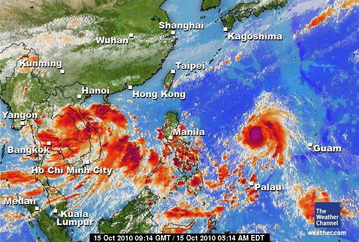
Orkaan (MEGI) op weg naar de Filipijnen
Megi lijkt, als een categorie 4 orkaan, de Filipijnen hard te gaan treffen. Wat voor veel neerslag en daarbij behorende ellende zal gaan zorgen. (Modderstromen, aardverschuivingen).
Momenteel is Megi nog een tropische storm, maar deze zal snel in kracht toenemen.
Megi lijkt, als een categorie 4 orkaan, de Filipijnen hard te gaan treffen. Wat voor veel neerslag en daarbij behorende ellende zal gaan zorgen. (Modderstromen, aardverschuivingen).
Momenteel is Megi nog een tropische storm, maar deze zal snel in kracht toenemen.

quote:Megi Set to Become Major Typhoon
Megi, the latest named storm for the western North Pacific Ocean basin, has formed over the southern Philippines Sea.
As of Wednesday morning, the center of Tropical Storm Megi was 310 miles west-southwest of Guam and more than 1,300 miles east of Manila, Philippines. Megi held highest sustained winds of 50 mph and was drifting towards the west at about 5 mph.
Megi will strengthen as it tracks towards the west and northwest over open seas for the next few days. Strengthening to a typhoon is forecast. Moreover, rapid strengthening to a major typhoon, even a "super" typhoon, is possible, as both oceanic and atmospheric conditions are favorable.
Eventually, Megi will either strike the main northern Philippines island of Luzon, or it will veer northward, away from Philippines, over the western Philippines Sea.
Direct typhoon landfall upon heavily settled northern Luzon would pose a serious threat to life and property.
Dat gaat weer flink zeer doen daar
Zal me benieuwen of ze er nu weer een paar achter elkaar voor de kiezen krijgen daar

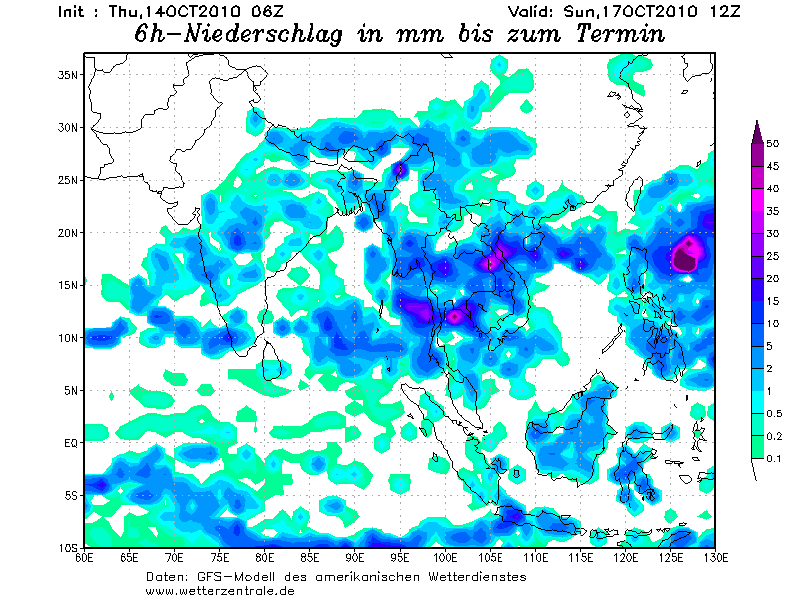
De neerslag die verwacht wordt op de Filipijnen.
Het lijkt er op dat Megi Landfall gaat maken en vervolgens rond de Filipijnen blijft hangen, wat voor extreme neerslag zal zorgen.
Het lijkt er op dat Megi Landfall gaat maken en vervolgens rond de Filipijnen blijft hangen, wat voor extreme neerslag zal zorgen.
Als dat uit komt kun je dat land wel afschaffen 
Maar die orkaan zal gewoon weg trekken.
Maar die orkaan zal gewoon weg trekken.
Doe mee met het voorspellen van het weer!
Weekvoorspelling | Week 6 (invullen tot 02-02 - 11:59)
Maandvoorspelling Februari (Invullen tot 31-01-2026)
Jaarvoorspelling 2025 / 2026
Weekvoorspelling | Week 6 (invullen tot 02-02 - 11:59)
Maandvoorspelling Februari (Invullen tot 31-01-2026)
Jaarvoorspelling 2025 / 2026
Ik ben benieuwd wat de nieuwe run van GFS laat zien.
Als dit uitkomt ziet het er inderdaad niet goed uit voor de Filipijnen.
Als dit uitkomt ziet het er inderdaad niet goed uit voor de Filipijnen.
Nou, nou, ze zijn er wel wat gewend hoor...quote:Op donderdag 14 oktober 2010 17:49 schreef SpeedyGJ het volgende:
Als dat uit komt kun je dat land wel afschaffen
Maar die orkaan zal gewoon weg trekken.
Niettemin nog steeds een behoorlijk pittige storm natuurlijk, maar we moeten ook niet overdrijven.
Misschien zwaait 'ie ook nog wel naar het noorden af... Wat prettiger voor de Filippijnen, maar dan zal Taiwan wel weer de volle laag krijgen.
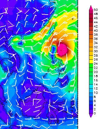
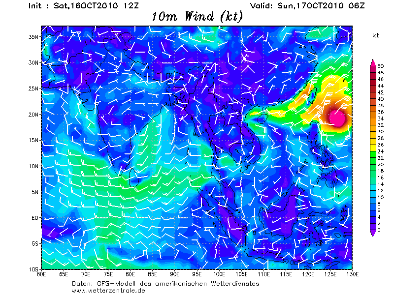
Gifje van zondag t/m vrijdag (12 uur verschil) van het windveld. Megi lijkt na de Filipijnen af te buigen richting Taiwan.
En lijkt ook weer in kracht toe te nemen.
En lijkt ook weer in kracht toe te nemen.
Ik hou mijn hart vast, in juli ook al getroffen daar...
Eerste super tyfoon van 2010
Megi zal de eerste super tyfoon van het seizoen zijn in de Stille Oceaan. Megi is momenteel een categorie 2 en ligt ongeveer 1740 kilometer ten oosten van Manilla. De storm beweegt zich voort met een snelheid van 15 kilometer per uur en trekt west-noordwestwaarts. Megi zal binnen 3 a 4 dagen het dun bevolkte gebied Luzon aan doen wat gelegen is ten noorden van de Filipijnen, na alle waarschijnlijkheid zal Megi met een categorie 4 aan land komen. De maximale windsnelheden die momenteel gemeten worden zijn 168 kilometer per uur en de windstoten bedragen ongeveer 200 kilometer per uur. Zondag op maandag lijkt Megi op haar hoogtepunt te zijn, volgens berekeningen kunnen er dan windstoten voor gaan komen van 295 kilometer per uur. Momenteel zijn er nabij het oog van de storm golven gemeten van zo'n 7 meter.
Megi is in Korea de naam van een meerval en is gerelateerd aan het "gevoel van nat", volgens het Hong Kong Obsevatory die de namen toewijst in de Stille Oceaan. Megi is de 15e storm van het seizoen. Eerder dit jaar hield tyfoon Conson flink huis op de Filipijnen. Daarbij kwamen 102 mensen om het leven en meer dan 70.000 huizen waren beschadigd of vernietigd
Weerdirect
Eerste super tyfoon van 2010
Megi zal de eerste super tyfoon van het seizoen zijn in de Stille Oceaan. Megi is momenteel een categorie 2 en ligt ongeveer 1740 kilometer ten oosten van Manilla. De storm beweegt zich voort met een snelheid van 15 kilometer per uur en trekt west-noordwestwaarts. Megi zal binnen 3 a 4 dagen het dun bevolkte gebied Luzon aan doen wat gelegen is ten noorden van de Filipijnen, na alle waarschijnlijkheid zal Megi met een categorie 4 aan land komen. De maximale windsnelheden die momenteel gemeten worden zijn 168 kilometer per uur en de windstoten bedragen ongeveer 200 kilometer per uur. Zondag op maandag lijkt Megi op haar hoogtepunt te zijn, volgens berekeningen kunnen er dan windstoten voor gaan komen van 295 kilometer per uur. Momenteel zijn er nabij het oog van de storm golven gemeten van zo'n 7 meter.

Megi is in Korea de naam van een meerval en is gerelateerd aan het "gevoel van nat", volgens het Hong Kong Obsevatory die de namen toewijst in de Stille Oceaan. Megi is de 15e storm van het seizoen. Eerder dit jaar hield tyfoon Conson flink huis op de Filipijnen. Daarbij kwamen 102 mensen om het leven en meer dan 70.000 huizen waren beschadigd of vernietigd
Weerdirect
Weer of geen weer, altijd actueel www.onweer-online.nl
De koers is iets noordelijker nu, maar nog steeds een Landfall op de Filipijnen.
Nu een windveld van 168 km/uur met windstoten tot 201 km/uur. (categorie 2)
De snelheid waarmee Megi zich verplaats is zo'n 17 km/uur
Nu een windveld van 168 km/uur met windstoten tot 201 km/uur. (categorie 2)
De snelheid waarmee Megi zich verplaats is zo'n 17 km/uur
Sinds wanneer is Luzon dunbevolkt?quote:Megi zal binnen 3 a 4 dagen het dun bevolkte gebied Luzon aan doen wat gelegen is ten noorden van de Filipijnen
Hooguit het gebied waar het oog overheen trekt is (gelukkig) vrij dunbevolkt, maar dat neemt niet weg dat er in het omliggende gebied nog een hoop slachtoffers kunnen gaan vallen natuurlijk...
Scherp! En ty, heb het even aangepastquote:Op vrijdag 15 oktober 2010 14:07 schreef Omniej het volgende:
[..]
Sinds wanneer is Luzon dunbevolkt?Manila ligt er notabene.
Hooguit het gebied waar het oog overheen trekt is (gelukkig) vrij dunbevolkt, maar dat neemt niet weg dat er in het omliggende gebied nog een hoop slachtoffers kunnen gaan vallen natuurlijk...

Weer of geen weer, altijd actueel www.onweer-online.nl

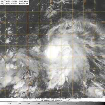
Die gast van Typhoon Fury is nu op weg naar het noorden van de Filipijnen, hoop dat hij mooie plaatjes schiet.
[ Bericht 23% gewijzigd door meteo-online op 16-10-2010 13:58:32 ]

[ Bericht 23% gewijzigd door meteo-online op 16-10-2010 13:58:32 ]
Weer of geen weer, altijd actueel www.onweer-online.nl
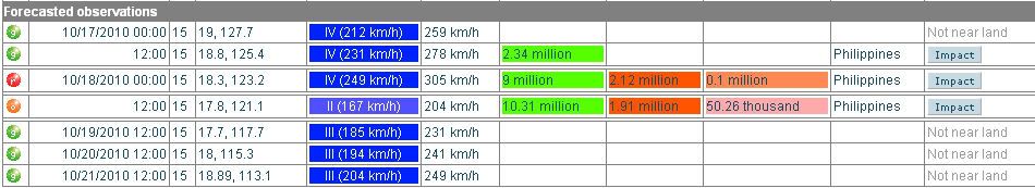
Het aantal mensen dat te maken krijgt met deze orkaan
[ Bericht 22% gewijzigd door #ANONIEM op 16-10-2010 18:53:55 ]
[ Bericht 22% gewijzigd door #ANONIEM op 16-10-2010 18:53:55 ]
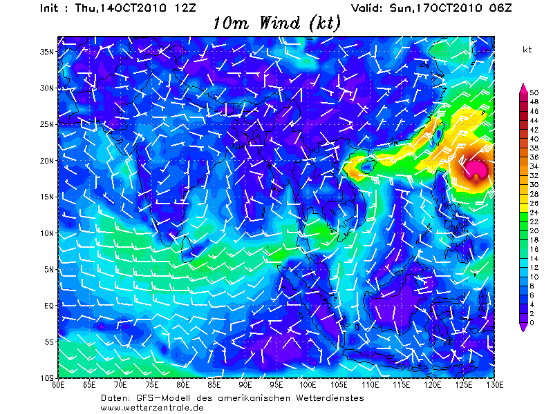
GFS laat Megi na de Filipijnen weer aansterken om vervolgens richting China te trekken.
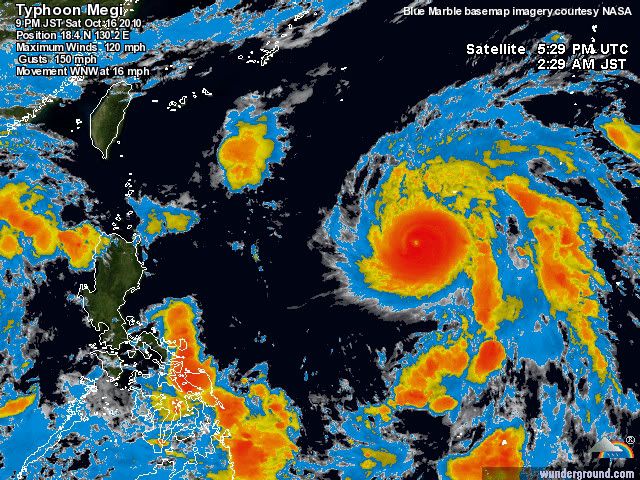
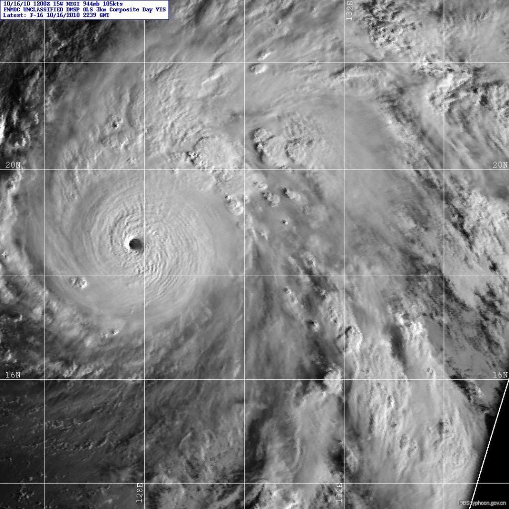
Momenteel een windveld van 193 km/uur met windstoten tot 241 km/uur. Daarmee wordt dit een categorie 4.
Megi heeft een bescheiden oog
Momenteel een windveld van 193 km/uur met windstoten tot 241 km/uur. Daarmee wordt dit een categorie 4.
Megi heeft een bescheiden oog
Ook goeiemorgen
Vind je het gek!
Aloa
Steeds harder, steeds sneller
Blijkbaar wil Magi daar wel naar luisteren
Vind je het gek!
Aloa
Steeds harder, steeds sneller
Blijkbaar wil Magi daar wel naar luisteren
Doe mee met het voorspellen van het weer!
Weekvoorspelling | Week 6 (invullen tot 02-02 - 11:59)
Maandvoorspelling Februari (Invullen tot 31-01-2026)
Jaarvoorspelling 2025 / 2026
Weekvoorspelling | Week 6 (invullen tot 02-02 - 11:59)
Maandvoorspelling Februari (Invullen tot 31-01-2026)
Jaarvoorspelling 2025 / 2026
bronquote:Super Typhoon Megi Threatening Millions in Philippines
Super Typhoon Megi continues to gain strength, and could strengthen a bit more before making a direct hit on the Philippines Monday.
As of Sunday morning, local time, maximum sustained winds were at 160 mph, the equivalent to a Category 5 hurricane.
Megi will threaten the Philippines early Monday when the center makes landfall over northern Luzon Island. However, the affects of Megi will begin to be felt over Luzon Island Sunday afternoon, local time, as the outer rain bands begin to reach the island.
Prior to landfall, further strengthening is likely as Megi tracks over some of the warmest ocean water on the planet, currently 86-90 degrees F. Despite Megi being a Super Typhoon, interaction with land may cause some slightly weakening in the couple of hours leading up to landfall.
Typhoons in the Western Pacific Ocean are named super typhoons once their sustained winds reach 150 mph. Therefore, a super typhoon is the equivalent of a top-end Category 4 or Category 5 hurricane.
Damage from super typhoons is catastrophic. Residents of Luzon are already bracing for Megi. More than 20 inches of rain is expected to fall over Luzon Island, resulting in widespread flooding and triggering deadly landslides. Maximum sustained winds could reach or even exceed 145 mph at landfall, causing widespread damage and destruction. The nation's capital city of Manila will likely be spared from the worst of Megi, though squally rains will still impact the city.
As Megi approaches the Philippines, the Flipinos will name the storm Juan as they use a different naming system than the rest of the Western Pacific countries.

Mooie Sitequote:Op zaterdag 16 oktober 2010 13:53 schreef meteo-online het volgende:
Die gast van Typhoon Fury is nu op weg naar het noorden van de Filipijnen, hoop dat hij mooie plaatjes schiet.
[ afbeelding ]
37m/s

Doe mee met het voorspellen van het weer!
Weekvoorspelling | Week 6 (invullen tot 02-02 - 11:59)
Maandvoorspelling Februari (Invullen tot 31-01-2026)
Jaarvoorspelling 2025 / 2026
Weekvoorspelling | Week 6 (invullen tot 02-02 - 11:59)
Maandvoorspelling Februari (Invullen tot 31-01-2026)
Jaarvoorspelling 2025 / 2026
Megi is nu cat5 en zal op land afzwakken naar cat2 om vervolgens vrolijk door te groeien naar cat4
Weer of geen weer, altijd actueel www.onweer-online.nl
Nee hoger dan cat5 kan niet...... Hier nog een plaatje...quote:Op zondag 17 oktober 2010 16:35 schreef Co_OL het volgende:
Met CAT5 aan landzou Megi nog meer kunnen groeien aan kracht?

Weer of geen weer, altijd actueel www.onweer-online.nl
quote:Megi neemt in kracht toe
De tyfoon Megi is vandaag in kracht toegenomen en stevent af op het noorden van de Filipijnen, waar het natuurfenomeen morgen zou aankomen. De lokale autoriteiten hebben duizenden mensen verplicht geëvacueerd.
Rukwinden
De weerkundigen verwachten dat Megi, die ze als een super-tyfoon omschrijven, in de provincie Cagayan, in het uiterste noorden, aan land zal komen. Vandaag bevond de tyfoon zich 450 kilometer ten oosten van de Filipijnen, met rukwinden tot 195 km/u. De sterkste rukwinden kunnen 230 km/u halen, verwacht de weerkundige dienst. Duizenden mensen in het noorden van het land zijn uit voorzorg geëvacueerd.


DAnkjewel, dus nog ff afwachten, ik hoop dattie weer zo gaat instorten en weinig schade aanricht. Er wonen daar domweg te veel mensen.
be nice or go away
Dat had ik ook verwacht.quote:Op zondag 17 oktober 2010 18:57 schreef Frutsel het volgende:
[..]
Valt me eigenlijk nog wat tegen, had hem al onder de 900 verwacht
Even afwachten hoe laag het daadwerkelijk wordt.
Ik heb het gevoel dat hij steeds meer zuidwestelijk gaat dan eerst
Nog ff en hij gaat recht op Manila af
Nog ff en hij gaat recht op Manila af
Signal nr 4 is volgens mij het gevaarlijkstequote:Juan changes course, Manilla under signal nr,1
Signal number 4 still hoisted over Cagayan, Isabela provinces
MANILA, Philippines – Metro Manila was placed under public storm signal number 1 by state weather bureau PAGASA Sunday night as typhoon Juan (international name Megi) changed direction as it continued to bear down on Northern Luzon.
Storm signal number 4 remains hoisted over Cagayan and Isabela provinces, while Batanes, Calayan, the Babuyan group of islands, Apayao, Kalinga, the Mountain Province, Ifugao, Quirino, Nueva Vizcaya, and Northern Aurora are under signal number 3.
locos Norte, Ilocos Sur, Abra, La Union, Benguet, and rest of Aurora were placed under storm signal number 2 while signal number 1 was declared in Pangasinan, Tarlac, Nueva Ecija, Polillio Island, Cavite, Bulacan, Pampanga, Bataan, Zambales, Northern Quezon, Metro Manila, and Rizal.
The typhoon slightly slowed down as it moves west-southwest at 20 kilometers per hour (kph), PAGASA said in its 11 p.m. briefing
als wat? Cat.4 ?quote:Op zondag 17 oktober 2010 19:19 schreef aloa het volgende:
GFS stuurt 'm na de Filipijnen richting Taiwan.
893 mb is de laagst gemeten luchtdrukquote:Op zondag 17 oktober 2010 18:57 schreef Frutsel het volgende:
[..]
Valt me eigenlijk nog wat tegen, had hem al onder de 900 verwacht
quote:The world's strongest tropical cyclone of 2010 is Super Typhoon Megi, which intensified into an extremely dangerous Category 5 super typhoon with 180 mph winds this morning. We are fortunate to have a hurricane hunter aircraft in Megi, as part of the Interaction of Typhoon and Ocean Project (ITOP), which is studying how the ocean responds to typhoon growth and movement in the Western Pacific Ocean. As part of ITOP, a C-130 hurricane hunter aircraft was in Megi this morning, and measured some truly remarkable winds and pressures. At 8:09am EDT (12:09 UTC), the aircraft measured winds at flight level (8,000 feet) of 220 mph. The SFMR surface wind measurement instrument recorded surface winds of 186 mph in regions where heavy rain was not contaminating the measurement, but found surface winds of 199 mph in one region of heavy rain. Now, this measurement is considered contaminated by rain, but at very high wind speeds, the contamination effect is less important than at lower hurricane wind speeds, and it is possible than Megi's surface winds are close to a sustained 200 mph. This is supported by the flight level winds of 220 mph, which support surface winds of 199 mph, using the usual 10% reduction rule of thumb. The Hurricane Hunters measured a surface pressure of 893 mb at 12 UTC. This is a phenomenally low pressure, ranking Megi as the 20th strongest typhoon ever recorded in the Western Pacific. Only three Atlantic hurricane have been more intense than Megi--Wilma (2005) at 882 mb, Gilbert (1988) at 888 mb, and the 1935 Labor Day Hurricane, at 892 mb. Megi's intensity easily beats out 2010's other two Category 5 storms, March's Tropical Cyclone Ului in the South Pacific and the East Pacific's Hurricane Celia of June, which both peaked at 160 mph winds. It is still possible that Megi will intensify further, as wind shear is low, less than 10 knots, SSTs are very warm, and the ocean has a very high total heat content.
<Analyses at 17/18 UTC>
Scale Large
Intensity Very Intense
Direction and speed of movement WSW 15km/h(9kt)
Central pressure 890hPa
Maximum wind speed near the center 60m/s(120kt)
Maximum wind gust speed 85m/s(170kt)
Area of 50kt winds or more Wide 200km(110NM)
Area of 30kt winds or more NE650km(350NM)
[ Bericht 13% gewijzigd door meteo-online op 17-10-2010 21:19:44 ]
Scale Large
Intensity Very Intense
Direction and speed of movement WSW 15km/h(9kt)
Central pressure 890hPa
Maximum wind speed near the center 60m/s(120kt)
Maximum wind gust speed 85m/s(170kt)
Area of 50kt winds or more Wide 200km(110NM)
Area of 30kt winds or more NE650km(350NM)

[ Bericht 13% gewijzigd door meteo-online op 17-10-2010 21:19:44 ]
Weer of geen weer, altijd actueel www.onweer-online.nl
890 hPa... Dan zijn er in de Atlantische Oceaan maar 2 orkanen geweest die een lagere luchtdruk hadden.
quote:Only three Atlantic hurricane have been more intense than Megi--Wilma (2005) at 882 mb, Gilbert (1988) at 888 mb, and the 1935 Labor Day Hurricane, at 892 mb.
Dit wordt een catastrofe
[ Bericht 1% gewijzigd door #ANONIEM op 17-10-2010 22:24:38 ]
quote:According to the Saffir-Simpson damage scale the potential property damage and flooding from a storm of Megi's strength (category 5) at landfall includes:
Storm surge generally greater than 5.5 metres (18 feet) above normal.
Complete roof failure on many residences and industrial buildings.
Some complete building failures with small utility buildings blown over or away.
All shrubs, trees, and signs blown down.
Complete destruction of mobile homes.
Severe and extensive window and door damage.
Low-lying escape routes are cut by rising water 3-5 hours before arrival of the centre of the storm.
Major damage to lower floors of all structures located less than 4.6 metres (15 feet) above sea level and within 460 metres (500 yards) of the shoreline.
Massive evacuation of residential areas on low ground within 8-16 km miles (5-10 miles) of the shoreline may be required.
There is also the potential for flooding further inland due to heavy rain.
[ Bericht 1% gewijzigd door #ANONIEM op 17-10-2010 22:24:38 ]
Heb echt medelijden met die mensen daar, jammer dat er alleen forums zijn die er berichten over schrijven. De media zal niets schrijven omdat we geen economische binding ermee hebben lijkt het wel 
Weer of geen weer, altijd actueel www.onweer-online.nl
Als het echt een enorme catastrofe wordt, zullen de media er ook wel over gaan berichten... Van tevoren gaat sowieso niet gebeuren natuurlijk, 't komt pas in het nieuws als er écht een hoop schade is.quote:
Heb echt medelijden met die mensen daar, jammer dat er alleen forums zijn die er berichten over schrijven. De media zal niets schrijven omdat we geen economische binding ermee hebben lijkt het wel
Zo, dat is kutnieuws.  Die mensen daar hebben het al niet best. Ben ook benieuwd hoe die typhoon straks door zal schieten, alhoewel ie dan waarschijnlijk al in kracht zal zijn afgenomen...
Zijn er geen engelse websites met dit bericht en info die het nu volgen?
Zijn er geen engelse websites met dit bericht en info die het nu volgen?
|
|