WKN Weer, Klimaat en Natuurrampen
Lees alles over het onstuimige weer op onze planeet, volg orkanen en tornado's, zie hoe vulkanen uitbarsten en hoe Moeder Aarde beeft bij een aardbeving. Alles over de verwoestende kracht van onze planeet en tal van andere natuurverschijnselen.


quote:In de Verenigde Staten heeft zich een totale omslag voltrokken. In Texas registreerde El Paso afgelopen vrijdag met -8,9º een koude(dag)record, vandaag kan het datum(warmte)record uit 1904 worden gebroken. El Paso ‘stoomt’ namelijk op naar mogelijk ruim 26 graden. In Oklahoma, waar donderdag 10 februari een nieuw ‘staterecord’ werd gevestigd (Nowata -35,0º) worden morgen middagtemperaturen boven 20 graden verwacht.
Jan Visser
Another Big Snowstorm Next Week... Seriously?
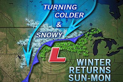
As reflected in feedback on AccuWeather.com's Facebook page, the prospect for more snow is the last thing most people want to hear right now.
Unfortunately, residents across the snow-laden northern Plains and Upper Midwest may not just see more snow next week, but a significant amount of it. For much of that area, this will be coming after a record-setting snowy winter that has yielded one of the most impressive snowpacks observed in more than 60 years!
This year's spring flooding has already been flagged as a major problem for the region, and any more snow that falls will only make the situation worse.
A storm set to plow into the Pacific Northwest this weekend is the first big concern next week for the northern Plains and Upper Midwest. While it's still too early to determine exactly where the heaviest snow will fall between the northern Rockies and Great Lakes, there is likely to be a zone that picks up a hefty amount, perhaps between 6 and 12 inches.
Most of this snow is expected to hit Sunday into Monday.
Early indications point to areas from Montana into North Dakota, Minnesota and northern Wisconsin as the heaviest zone, with a significant amount also expected in the Colorado Rockies.
People from Great Falls, Mont. to Bismarck and Fargo, N.D., St. Cloud and Minneapolis, Minn., and Hayward, Wis. should monitor the expectations regarding this storm to determine how significantly they'll be affected.
As with many spring storms, the nature of the snow next week will be heavy and wet, making shoveling an exhausting, strenuous task. If that weren't enough, residents have commented that they will have to lift all the heavy, wet snow up on top of the 4-foot snowbanks still lining their driveways.
Lighter snow, though still capable of disrupting travel and causing problems, could affect areas farther south across the Plains as well, on the back side of the storm. Denver is an area of concern for some potential problems Sunday night into Monday.
bron Accuweather
Bijna zomer, in Montana liggen nog meters sneeuw.
videoquote:In the Glacier National Park in Montana, even though summer is less than a week away, they are still working at clearing the roads of snow.

Sneeuw.quote:Op zondag 19 juni 2011 10:31 schreef aloa het volgende:
Bijna zomer, in Montana liggen nog meters sneeuw.
[..]
video
_@/' _@/' _@/' _@/' _@/' _@/' _@/' _@/' _@/' _@/' _@/' _@/' _@/'? '@_