WKN Weer, Klimaat en Natuurrampen
Lees alles over het onstuimige weer op onze planeet, volg orkanen en tornado's, zie hoe vulkanen uitbarsten en hoe Moeder Aarde beeft bij een aardbeving. Alles over de verwoestende kracht van onze planeet en tal van andere natuurverschijnselen.


Ik weet het. Om dan ook een tornado te zien moet je geluk hebben. Ik denk dat je zo'n chase vakantie het beste kunt beschouwen als een reguliere sightseeing vakantie waarbij je met een beetje geluk een mooie supercell ziet en heel heel misschien een tornado.


Zes doden door tornado's in VS
Zware stormen in de Amerikaanse deelstaten Arkansas, Missouri en Ikkinois hebben vrijdag behalve veel materiële schade en elektriciteitspannes ook minstens zes mensenlevens geëist.
In het stadje Cincinnati, in het noordwesten van Arkansas, vielen drie doden door de passage van een tornado. Ook in Missouri vielen drie doden door tornado's: twee in het rurale gebied Dent, een nabij Rolla (160 km ten zuidwesten van Saint Louis). In Illinois raakten zeker vijf mensen zwaar gewond door stormweer. (afp/mvl)
hln
Momenteel nog steeds tornado waarschuwingen in Mississippi & Alabama.
Tornado in Cincinati was trouwens een EF3.
[ Bericht 28% gewijzigd door Drassss op 01-01-2011 17:09:03 ]
Tornado in Cincinati was trouwens een EF3.
[ Bericht 28% gewijzigd door Drassss op 01-01-2011 17:09:03 ]

Ouch. Ik houd het weer in de VS meestal niet echt in de gaten in deze periode van het jaar. Had dit niet verwacht.
Het is ook niet het tornadoseizoen. Komt behoorlijk onverwacht.quote:Op zondag 2 januari 2011 21:47 schreef Disorder het volgende:
Ouch. Ik houd het weer in de VS meestal niet echt in de gaten in deze periode van het jaar. Had dit niet verwacht.
Ja normaal gesproken gaat het pas los begin Maart, maar dit is echt belachelijk vroeg. Ik hoorde dat er in zuidwest Oklahoma al een storm systeem was de 30/31ste en dat is dus een flinke lijn geworden richting het oosten...quote:Op zondag 2 januari 2011 21:50 schreef aloa het volgende:
[..]
Het is ook niet het tornadoseizoen. Komt behoorlijk onverwacht.
Op verschillende sites kan je echt de ravage zien.
Daar komen een paar beste blokken ijs naar beneden.quote:
Patience is not one of my virtues, neither is memory. Or patience for that matter.
Zijn zwembad.. dat zou denk ik het laatste zijn waar hij zich zorgen om heeft gemaakt denk ikquote:Op zondag 2 januari 2011 22:02 schreef popolon het volgende:
[..]
Daar komen een paar beste blokken ijs naar beneden.Vraag me af of z'n zwembad schadevrij was.
Zo'n liner is duur.quote:
[..]
Zijn zwembad.. dat zou denk ik het laatste zijn waar hij zich zorgen om heeft gemaakt denk ik
Patience is not one of my virtues, neither is memory. Or patience for that matter.
Ja tevens waren er toen ook enorm veel wateroverlast in Oklahoma City area.. Dat zal ook niet helpenquote:
[..]
Zo'n liner is duur.Maar inderdaad, er kan van alles kapot met zoveel geweld.
Kickje omdat het kan.
Donderdagmiddag/avond is er 100% kans op zware onweersbuien in Oklahoma/Arkansas/Mississippi & Lousiana.
Voor vandaag ook een kleine kans op stormen.. maar morgen is de "grote" 1e dag van het seizoen.
Donderdagmiddag/avond is er 100% kans op zware onweersbuien in Oklahoma/Arkansas/Mississippi & Lousiana.

Voor vandaag ook een kleine kans op stormen.. maar morgen is de "grote" 1e dag van het seizoen.
Update:
Groot gebied nu tornado watch en de komende uren trek het neerslaggebied vanuit Texas/Oklahoma oostwaarts.
- geel -> Tornado watch
Groot gebied nu tornado watch en de komende uren trek het neerslaggebied vanuit Texas/Oklahoma oostwaarts.

- geel -> Tornado watch
Regent hier behoorlijk. Er is nog geen tornado watch, maar het zou me niets verbazen als die er vanavond komt. Toch zal het wel meevallen; ik zit te oostelijk.
Ow ja, hier is Central Kentucky.
Ow ja, hier is Central Kentucky.
Jemig, ik was het al bijna vergeten.. Het nieuwe tornadoseizoen staat weer op het punt van beginnen 
's Avonds een man, overdags rustig an
Geen probleem, wij schudden je wel wakkerquote:
Jemig, ik was het al bijna vergeten.. Het nieuwe tornadoseizoen staat weer op het punt van beginnen

Het viel inderdaad allemaal wel "mee". Het was een enorm lang gebied wat vaak funest is voor krachtige tornado's. Cellen kregen niet de kans om te groeien vandaar het alleen enorme onweersbuien waren.
As zondag weer kans op stormen in oa Oklahoma. Nog even afwachten
As zondag weer kans op stormen in oa Oklahoma. Nog even afwachten
Accuweatherquote:St. Louis, Little Rock, Memphis at Risk for Severe Storms Again
A new outbreak of severe thunderstorms is set to unfold over communities that were slammed by severe weather this past Thursday.
Severe storms rattled areas from Oklahoma, Arkansas, northern Louisiana through the Tennessee Valley on Thursday. Several tornadoes touched down, while high winds and hail struck many cities and towns in this zone.
Flooding downpours accompanied the nasty storms, killing three people in Kentucky.
The ingredients will come together for another round of severe weather as a storm system currently impacting the Southwest with low-elevation snow, locally severe thunderstorms and flooding downpours ejects eastward into the southern Plains Sunday and Sunday night.
Moisture will surge in from the Gulf of Mexico ahead of the storm system, providing enough fuel for a dangerous outbreak of severe storms by Sunday night.
Enough moisture may be in place for few violent storms to develop late Sunday afternoon or evening over portions of Oklahoma, northern Texas to eastern Kansas and western Missouri.
Some cities that will first be under the line of fire include: Dallas and Tyler, Texas, Oklahoma City and Tulsa, Okla., Wichita, Kan., and perhaps as far north as Kansas City, Mo.
The thunderstorms will really be gathering strength as they progress eastward overnight. This will put much of northern Louisiana, Arkansas, Missouri to southern Illinois at risk.
The thunderstorms will be capable of spawning tornadoes that will threaten lives and property if they touch down in populated areas.
Damaging winds over 60 mph and hail the size of quarters and larger will also be a major threat with the storms.
The high winds could topple trees onto power lines or even vehicles and houses. Scattered power outages can also occur.
Springfield and St. Louis, Mo., Little Rock, Ark., and Shreveport, La., will be in the path of severe storms Sunday night.
The potentially damaging thunderstorms will continue to head eastward across the South on Monday. Communities from the Ohio Valley to Mississippi could get hit.
Cities at risk will include Cincinnati, Memphis and Nashville, Tenn., to Tupelo, Miss.
It is not out of the question that a few thunderstorms spreading all the way into the mid-Atlantic could also turn severe.
Torrential downpours from the heaviest storms could result in flash flooding as well. Motorists are urged to avoid driving over roadways with water over them.
People should stay alert to the severe weather and flooding situation, including before getting into a vehicle and traveling. High winds, tornadoes, and large hail pose serious threats to people whether they are in small vehicles or large semi-trucks.


Onderstaande link geeft ook wat extra info voor morgen:
http://www.weather.com/ou(...)t-deja-vu_2011-02-25
http://www.weather.com/ou(...)t-deja-vu_2011-02-25
quote:OKLAHOMA CITY -- Sunday will be mainly windy and mild with temperatures warming into the 60s and 70s. However, a slight risk of severe thunderstorms and a high risk of wildfires will develop by late afternoon.
Regarding the severe weather risk, isolated supercell thunderstorms may develop after 3 p.m. east of line from Cherokee to Hinton to Lawton. Any storm that develops will move rapidly eastward at 50 mph and could produce large hail, damaging winds, and tornadoes. The probability increases from 30 percent in central Oklahoma to 60 percent in far eastern parts of the state.
As for the risk of wildfires, a red flag warning is in effect for areas west of an Alva to Chickasha to Duncan line between the hours of 11 a.m. and 9 p.m. Westerly winds of 20 to 30 mph with gusts to 50 mph will combine with very low humidity to produce extreme fire conditions.
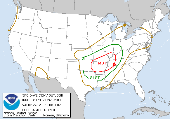
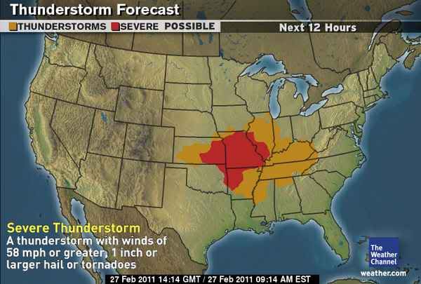
Hagelstenen van 2,5 cm of meer
Wind tot bijna 100 km.uur en tornado's worden er verwacht.
[ Bericht 6% gewijzigd door #ANONIEM op 27-02-2011 15:29:44 ]
Wind tot bijna 100 km.uur en tornado's worden er verwacht.
[ Bericht 6% gewijzigd door #ANONIEM op 27-02-2011 15:29:44 ]
quote:OKLAHOMA CITY -- Sunday will be mainly windy and mild with temperatures warming into the 60s and 70s. However, a slight risk of severe thunderstorms and a high risk of wildfires will develop by late afternoon.
Regarding the severe weather risk, isolated supercell thunderstorms may develop after 3 p.m. east of line from Cherokee to Hinton to Lawton. Any storm that develops will move rapidly eastward at 50 mph and could produce large hail, damaging winds, and tornadoes. The probability increases from 30 percent in central Oklahoma to 60 percent in far eastern parts of the state.
As for the risk of wildfires, a red flag warning is in effect for areas west of an Alva to Chickasha to Duncan line between the hours of 11 a.m. and 9 p.m. Westerly winds of 20 to 30 mph with gusts to 50 mph will combine with very low humidity to produce extreme fire conditions.
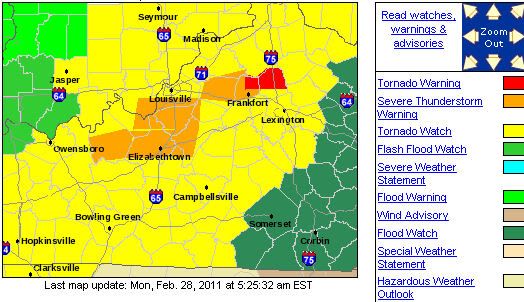
Update...
Cellen beginnen zich nu te vormen en veel chasers op pad.
http://www.news9.com/Global/category.asp?C=167025
Cellen beginnen zich nu te vormen en veel chasers op pad.
http://www.news9.com/Global/category.asp?C=167025
SPOILEROm spoilers te kunnen lezen moet je zijn ingelogd. Je moet je daarvoor eerst gratis Registreren. Ook kun je spoilers niet lezen als je een ban hebt.Prachtige live beelden! Tornado in de maak.
Klopt ja.. Cell is nu noord van Lexington.quote:
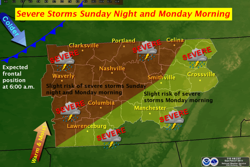
Nog steeds een tornado warning bij Louisville
Men geeft nog steeds een moderate risk af voor het gebied in Tennesse/Kentucky met kans op grote tornado's.

Die 2 tornado's in Oklahoma/Kansas staan dus in het filmpje een paar posts boven.. voor de rest nog "vrij" weinig ja.
Momenteel nog een groot gebied in tornado watch.
Edit:
Momenteel nog een groot gebied in tornado watch.
Edit:
SPOILEROm spoilers te kunnen lezen moet je zijn ingelogd. Je moet je daarvoor eerst gratis Registreren. Ook kun je spoilers niet lezen als je een ban hebt.Hier kan je het weer in Tennessee volgen. Momenteel alleen grote onweersbuien en nog niks ernstigs.
[ Bericht 70% gewijzigd door Drassss op 28-02-2011 15:35:23 ]
Het ging flink tekeer vannacht hier in Central Kentucky. Veel onweer en harde windstoten. De tornado warning duurde tot 9 AM, er is alleen een flood warning. Nu regent het alleen nog maar, vandaar die warning.
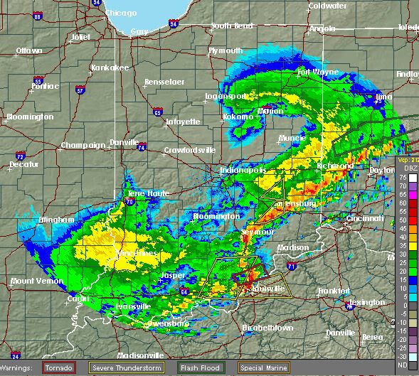
Oost van Cleveland weer een tornado warning, ook boven Greensboro een tornado warning.
Edit: Wateroverlast in oa Tennessee. Meer dan 4 inch regen gevallen binnen 24 uur. De staat kent nu nieuwe "rivieren"
http://www.weather.com/ou(...)-tornado-forms-19814
Filmpje tornado OK/KA
[ Bericht 35% gewijzigd door Drassss op 28-02-2011 22:27:26 ]
Edit: Wateroverlast in oa Tennessee. Meer dan 4 inch regen gevallen binnen 24 uur. De staat kent nu nieuwe "rivieren"
http://www.weather.com/ou(...)-tornado-forms-19814
Filmpje tornado OK/KA
[ Bericht 35% gewijzigd door Drassss op 28-02-2011 22:27:26 ]
quote:A confirmed tornado in Franklin County is blamed for the death of a 61 year old man who was trapped under debris. Melvin Hambrick's mobile home was destroyed when the tornado touched down on U-T Farm Road in Estill Springs. His daughter and grandson crawled out but he died at the scene. Officials say the twister uprooted trees and narrowly missed an elementary school. Early on officials were pretty certain a tornado had hit their community. The National Weather Service in Huntsville, Alabama says a preliminary investigation indicates that an EF-2 force tornado hit Franklin County.
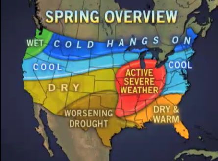
Spring 2011 Forecast: Tornadoes, Flooding, Drought
[ Bericht 28% gewijzigd door #ANONIEM op 04-03-2011 12:30:03 ]
[ Bericht 28% gewijzigd door #ANONIEM op 04-03-2011 12:30:03 ]
Tornado treft Louisiana
Als gevolg van een tornado in de Amerikaanse staat Louisiana zijn zaterdag een dode en veertien gewonden gevallen. Het zwaarst werd de plaats Rayne getroffen, 100 kilometer ten westen van de hoofdstad van de deelstaat, Baton Rouge. Tientallen huizen in Rayne zijn volledig verwoest. Ongeveer 2500 mensen moesten uit de plaats worden geëvacueerd omdat gasleidingen waren gesprongen.
Het slechte weer in de regio met regens en harde wind belastte ook het carnavalsfeest in New Orleans in het zuidoosten van Louisiana. Dit feest is een van de populairste carnavalsfeesten in de Verenigde Staten. Ook de aangrenzende staat Mississippi is dit weekeinde door tornado's getroffen.
Bron De Pers
Als gevolg van een tornado in de Amerikaanse staat Louisiana zijn zaterdag een dode en veertien gewonden gevallen. Het zwaarst werd de plaats Rayne getroffen, 100 kilometer ten westen van de hoofdstad van de deelstaat, Baton Rouge. Tientallen huizen in Rayne zijn volledig verwoest. Ongeveer 2500 mensen moesten uit de plaats worden geëvacueerd omdat gasleidingen waren gesprongen.

Het slechte weer in de regio met regens en harde wind belastte ook het carnavalsfeest in New Orleans in het zuidoosten van Louisiana. Dit feest is een van de populairste carnavalsfeesten in de Verenigde Staten. Ook de aangrenzende staat Mississippi is dit weekeinde door tornado's getroffen.
Bron De Pers
Weer of geen weer, altijd actueel www.onweer-online.nl
quote:More dangerous tornado season expected
The 2011 tornado season has started quickly, with more reports of damage from storms and twisters in the past two days than there were during all of the first two months of 2010 -- a trend likely to continue well into spring.
Severe weather season, as it's often referred to by meteorologists, typically peaks during May, when meteorological conditions that lead to the development of dangerous thunderstorms are most abundant. These conditions -- including a sharp north-south temperature gradient -- have emerged early this year and, based on the expected weather pattern, will likely intensify in the coming months.
Heavy thunderstorms Sunday and Monday affected a large region from the Plains eastward to the mid-Atlantic and the Carolinas, resulting in a fatality from a suspected tornado in Franklin County, Tenn., according to WKRN-TV. Over those two days, there were 389 preliminary damage reports (wind damage, hail and tornadoes), including 12 reports of tornadoes.
The same type of event occurred just last week, when there were 32 reports of tornadoes in the Tennessee Valley and Deep South on Thursday.
Through Monday, there have been about 800 preliminary reports of damage from severe weather in 2011, more than 2.5 times greater than the number through the first two months of 2010. January and February 2010 generated 307 reports, including just one February tornado.
Thunderstorms and tornadoes develop out of a strong temperature contrast from north to south across the country, along with an ample supply of moisture from the Gulf of Mexico. Storm systems emerging from the Rockies and heading east ignite the meteorological fuel.
This is precisely the type of weather pattern that is expected to continue at least through May, which is when tornado season typically peaks.
The federal government's Climate Prediction Center forecast for March through May calls for temperatures that are likely to be warmer than average in the southern part of the country and cooler than average in the northern part of the country. Thus, the contrast will be more intense than in a typical year.
In addition, the storm track is expected to remain more active than normal because of the ongoing La Nina. This is one of the typical results of a La Nina: more storms moving out of the Pacific Northwest and northern Rockies into the Plains and eventually the eastern part of the United States than during a non-La Nina year.
That's been the case recently, and these storms have pulled moisture north from the Gulf of Mexico into the sharp temperature gradient, resulting in lines of dangerous thunderstorms. Last year, the tornado season started slowly, in part because it was cooler than average in the Deep South during the latter part of winter through the first part of spring.


| Forum Opties | |
|---|---|
| Forumhop: | |
| Hop naar: | |