WKN Weer, Klimaat en Natuurrampen
Lees alles over het onstuimige weer op onze planeet, volg orkanen en tornado's, zie hoe vulkanen uitbarsten en hoe Moeder Aarde beeft bij een aardbeving. Alles over de verwoestende kracht van onze planeet en tal van andere natuurverschijnselen.


quote:Britain braced for 'exceptional' storm
www.telegraph.co.uk
Britain battened down the hatches yesterday as forecasters warned that an "exceptional" storm could cause traffic chaos when it batters the country.
# Official warnings: Met Office | Coastguard Agency
# Have your say: Share your storm experiences
# Send in your photos of the storm and the damage it caused
Emergency plans were being drawn up last night in anticipation of flooding across the country today.
Breaking waves - Britain braced for 'exceptional' storm
Forecasters advised people not to venture out amid fears that 80mph winds will cause extensive damage
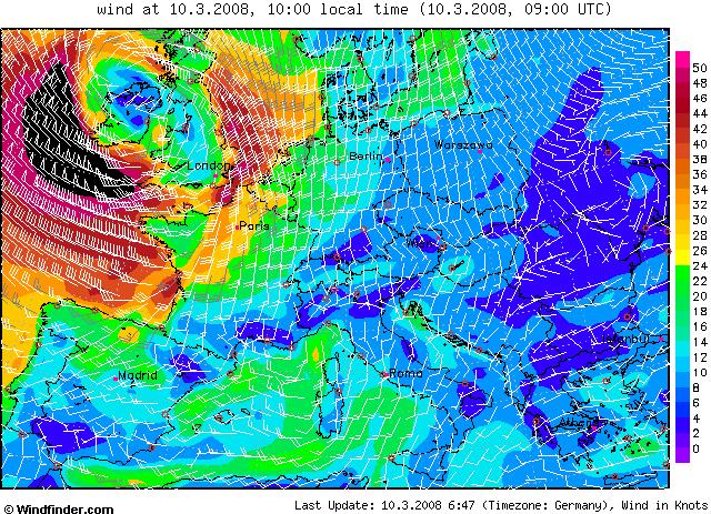
The potentially devastating threat posed by a storm gathering off Britain led to an emergency meeting of Government officials. Floods, violent winds and torrential downpours are expected to cause chaos after weather conditions and spring tides combined to create an “exceptional” storm.
Last night, an emergency meeting was held in Whitehall to plan a response. Ministers were not due to take part, although the Prime Minister is thought to have been briefed afterwards by telephone. Forecasters yesterday warned people to stay indoors, avoid coastal areas and drive only if absolutely necessary.
Airports warned that flights could be cancelled, while motorists were urged not to drive as the storm promised to cause serious disruption to travellers. Some ferry services were also scrapped
Forecasters advised people not to venture out amid fears that 80mph winds will damage buildings, topple trees and cut power supplies.
The storm developed from a band of exceptionally low pressure that crossed the Atlantic yesterday, combined with higher than average spring tides. The Met Office put severe weather warnings in place across all of England, Wales, Northern Ireland and large parts of Scotland. The South will take the heaviest battering during the storm, which is expected to continue into this evening.
Yesterday, Havant borough council, Hants, began putting storm boards in place around Hayling Island, near Portsmouth, while residents in Cornwall stacked sandbags.
The Environment Agency issued severe flood warnings across Devon and Cornwall, and a further six flood warnings and 31 flood watches across the country.
Mark Bettinson, 27, a barman, said: “We’ve been hit with flood water before and it’s a nightmare. We’re just going to cross our fingers and hope for the best.”
David Rooke, the agency's head of flood risk management, said: "The strong winds will combine with spring high tides to significantly elevate the water levels along the coast which is likely to cause some flooding. We understand that people are fascinated by the sea but at times like this we do urge them not to go and watch the high waves - it is extremely dangerous and only takes a few seconds for someone to be knocked off their feet into the water."
# Storms that battered Britain in the past
# Telegraph weather: Five-day forecasts for you area
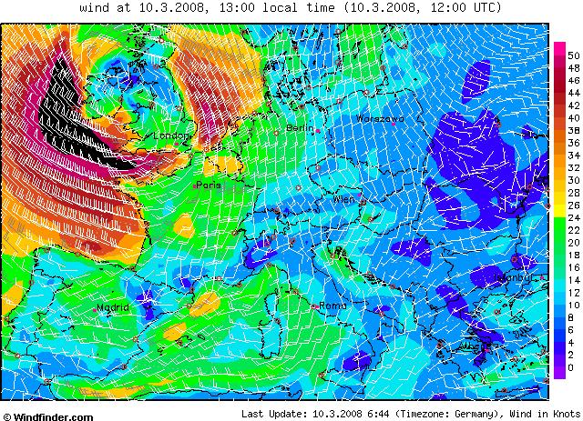
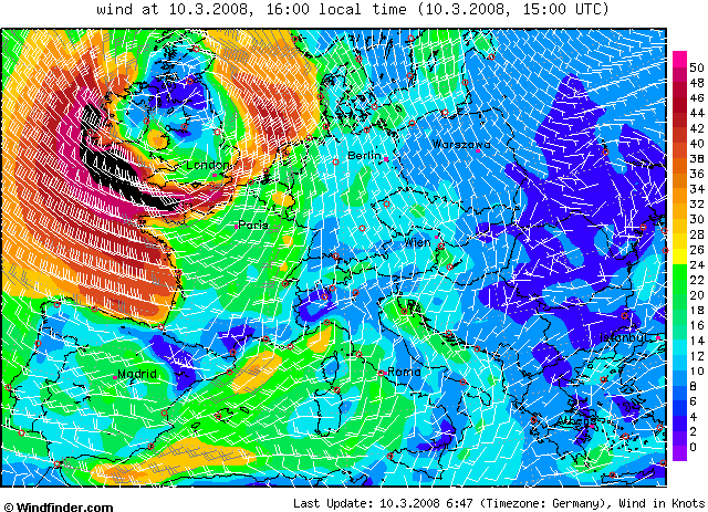
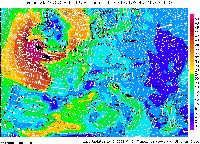
The fierce weather hit Britain last night and was expected to climax this morning. Further gale-force winds and storm conditions will hit swathes of the country tonight. Martin Young, the chief forecaster at the Met Office, said: "It will be very windy for many parts of the UK, but especially so across coasts in the south.
"Southerly winds are expected to strengthen during the early hours of Monday causing severe gales. After a brief respite, further westerly severe gales are forecast for later in the day and into the early hours of Tuesday." In a statement, the RAC motoring organisation warned drivers: "If you're planning on going on a journey over the next few days, please take extra care, especially on open stretches of exposed road and when crossing bridges or passing high-sided vehicles.
"Allow extra time for your journey and be careful if towing a caravan or trailer." A spokesman for Gatwick Airport said: "If the weather is as bad as currently predicted, there may be delays or cancellations." A Heathrow spokesman urged passengers to check with their airline before they travel.
P&O Ferries cancelled its Portsmouth to Bilbao service. The coastguard advised leisure sailors to avoid the sea until the storm passes. A spokesman added: "The public are advised not to go wave watching during these gales, as the sea will become very rough and affected coastal areas will become very dangerous."

Had Corbyn toch nog gelijk!!!
<a href="https://www.youtube.com/watch?v=yIl_jGh-LWE" target="_blank" rel="nofollow">Afleidingsmanoeuvre</a>
Nou, ik woon dus in Ierland, vlakbij Galway om precies te zijn, aan de westkust. En zo erg als vannacht heb ik het hier nog niet meegemaakt. En dit schijnt de stilte voor de storm te zijn aangezien we vannavond nog meer en heviger te verwachten hebben 
Maar vannacht was het al zo erg dat de deksel van ons kastje waarin de electriciteits meter zit (Die zitten in Ierland aan de buitenkant van het huis, een kleine nis in je huis welke wordt afgedekt met een plastic deksel, en dus gewoon egaal gelijk loopt met de muur) ervan is gewaaid!!
Maar vannacht was het al zo erg dat de deksel van ons kastje waarin de electriciteits meter zit (Die zitten in Ierland aan de buitenkant van het huis, een kleine nis in je huis welke wordt afgedekt met een plastic deksel, en dus gewoon egaal gelijk loopt met de muur) ervan is gewaaid!!
Remember all, if you don't sin, then Jesus died for nothing.
Samenzweringstheorieën behoren tot de wetenschap van onwetenden
Samenzweringstheorieën behoren tot de wetenschap van onwetenden
Hoorde net idd op het nieuws dat het 'geen kwestie is van uren' , maar van 'dagen', voordat het ergste voorbij is
Schiphol schijnt het ook nogal druk te hebben met uitwijkers die niet terecht kunnen in de UK.
[b]Op maandag 6 september 2010 00:28 schreef tong80 het volgende:[/b]
GVD Wat moet jij een trotse vader zijn :)
:P
GVD Wat moet jij een trotse vader zijn :)
:P
England gaat wel uit van overstromingen. En de vorige keer was het goed raak.quote:Op maandag 10 maart 2008 10:17 schreef Frutsel het volgende:
Hoorde net idd op het nieuws dat het 'geen kwestie is van uren' , maar van 'dagen', voordat het ergste voorbij is
Hier is ook een en ander overstroomd. Waterford, Wexford en Dublin zijn al bezig met zanddijken voor het vervolg van de stormquote:Op maandag 10 maart 2008 10:40 schreef Drugshond het volgende:
[..]
England gaat wel uit van overstromingen. En de vorige keer was het goed raak.

Remember all, if you don't sin, then Jesus died for nothing.
Samenzweringstheorieën behoren tot de wetenschap van onwetenden
Samenzweringstheorieën behoren tot de wetenschap van onwetenden
op www.sat24.com is t og wel mooi te zien, ziet er niet best uit
k vond t vanmorgen al een harde kouwe grafwind, maar het wordt erger dus...
Wind is nie zo heel erg, kan je je tegen kleden, Slagregens vind ik erger
k vond t vanmorgen al een harde kouwe grafwind, maar het wordt erger dus...
Wind is nie zo heel erg, kan je je tegen kleden, Slagregens vind ik erger
| Wordfeud: marcel-o |plug.dj/uptempo |<-- draai zelf je platen
Eerste stormmeldingen komen binnen via p2000:
quote:11:24:04 10-03-08 20 G BRAN PRIO 2 3756 HOUTWOLPLANTSOEN 282 OOSTERHOUT NB DIENSTVERLENING VERWIJDEREN BALKONSCHERM
11:39:10 10-03-08 19 G BRAN P 2 4550 BOULEVARD EVERTSEN VLISSINGEN HV Brittania (voormalig Hotel)
11:02:42 10-03-08 14 G BRAN Pr 3 Hobbemalaan 11 MUIDERBERG TS737 Dienstverlening/Hulpverlening/Stormschade
Life is Music
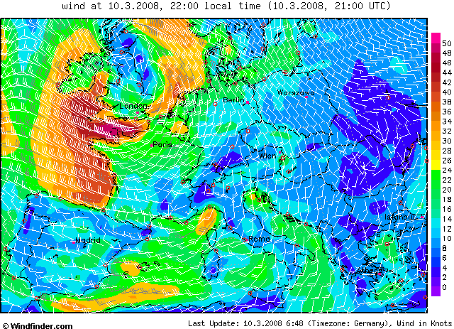
Men verwacht veel wind, maar ook veel regen en daarnaast ook nog springtij (inclusief stuwing door de wind kan dat tot erg hoge waterstanden leiden, denk maar eens aan de beruchte paarden bij ons)quote:Op maandag 10 maart 2008 10:17 schreef Frutsel het volgende:
Hoorde net idd op het nieuws dat het 'geen kwestie is van uren' , maar van 'dagen', voordat het ergste voorbij is
Hierbij een bericht van MetOffice, de Britse meteorologische dienst:quote:Floods, violent winds and torrential downpours are expected to cause chaos after weather conditions and spring tides combined to create an “exceptional” storm.
Bron: http://www.metoffice.gov.(...)2008/pr20080309.htmlquote:Severe Weather Update
9 March 2008
Parts of Southern Britain could see widespread disruption on Monday as severe gales move across the country.
Forecasters at the Met Office, the UK's national weather service, are working closely with the government agencies, emergency services, rail operators and power companies to plan for the disruption likely to be caused by winds up to 70 m.p.h in places.
The worst hit areas are expected to be parts of Wales, western and southern parts of England where all emergency responders are on alert and preparations have been put in place in readiness for the storm.
Graeme Leitch, Public Weather Assurance Manager at the Met Office, said: "Southerly winds are expected to strengthen during the early hours of Monday causing severe gales. Then, after a brief respite, further westerly severe gales are forecast for during the day and into the early hours of Tuesday. Coastal areas of the extreme Southwest could see gusts up to 80 m.p.h, with gusts of at least 60 m.p.h further inland. There could be a risk of disruption to transport links and power supplies.”
David Rooke, Head of Flood Risk Management at the Environment Agency said: “People living in properties in low lying exposed coastal areas of Wales, the Southwest and Southern England should make sure they are monitoring the situation by checking flood updates on the Environment Agency website or ringing Floodline.
"The strong winds will combine with spring high tides to significantly elevate the water levels along the coast which is likely to cause some flooding.
"We understand that people are fascinated by the sea but at times like this we urge them not to go and watch the high waves – it is extremely dangerous and only takes a few seconds for someone to be knocked off their feet, into the water.”
People are advised to stay in touch with the latest weather forecast and warnings on the Met Office website, and tune into local radio and TV. Those concerned by the risk of coastal flooding should call Floodline on 0845 988 1188 for the latest flood warnings in their area.
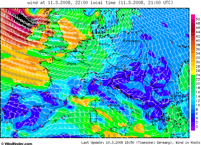
Maar 60 knopen wind op zee ten ZW van Wales/Ierland op de kaartjes die Drugshons postte, da's geen kattepis (integendeel: windkracht 11). Gelukkig wel alleen op volle zee vanmorgen, vanmiddag en vanavond wel 10-11 Bft nog noordelijker de Keltische Zee in en dan krijgen Cornwall en Devon ook met meer wind te maken (aan de kust stormt het dan).
En dan trekt er woensdag een 2e stormdepressie over, met de kern over Schotland heen zoals het nu lijkt. Dan zulen de Noordelijke delen van Ierland en Groot-Brittanie hinder ondervinden.
Hier in zeeland in is het weer droog neerslagzone is voorbij wel waait het harder.
vraagje weet iemand of er bij dit soort lagedrukgebieden de kern net als bij een orkaan gewoon rustig/windstil is?
vraagje weet iemand of er bij dit soort lagedrukgebieden de kern net als bij een orkaan gewoon rustig/windstil is?
ja hoor, dat is gewoon zo. Een orkaan is natuurlijk ook 'gewoon' een depressie.quote:Op maandag 10 maart 2008 14:22 schreef hondenfokker het volgende:
Hier in zeeland in is het weer droog neerslagzone is voorbij wel waait het harder.
vraagje weet iemand of er bij dit soort lagedrukgebieden de kern net als bij een orkaan gewoon rustig/windstil is?
Mooi voorbeeld in Nederland was 25 november 2005 toen het centrum van een depressie boven het noorden van het land lag, en daar ook een tijdje bleef liggen. In Friesland was het redelijk zonnig met weinig wind, hier in Amsterdam heb ik de hele dag de zon niet gezien, en werd ik zo ongeveer met fiets en al van de weg geblazen!
[b]Op maandag 6 september 2010 00:28 schreef tong80 het volgende:[/b]
GVD Wat moet jij een trotse vader zijn :)
:P
GVD Wat moet jij een trotse vader zijn :)
:P
In de kern is het inderdaad meestal rustig weer. Allen bij tropische orkanen is het centrum ook wolkenloos, dat is in onze streken over het algemeen niet zo.
Ik vlieg morgen om half 6 van bristol naar amsterdam. Hopelijk gaat dat meevallen. Als ze al vliegen dan.
History became legend, legend became myth.
Dit was het systeempje van 25-11-05, niet vreemd dat mensen in het noorden zich af vroegen waar wij het in vredesnaam over hadden.

[b]Op maandag 6 september 2010 00:28 schreef tong80 het volgende:[/b]
GVD Wat moet jij een trotse vader zijn :)
:P
GVD Wat moet jij een trotse vader zijn :)
:P
quote:Bron : BBC
Monday 10 March WEATHER WARNING Wind gusts up to 75 mph are possible in southwest England through the rest of today. Over Cornwall, and the Isles of Scilly 85mph is possible. These winds will be damaging. Heavy rain is only just easing but 10-15cm of snow could still fall above 300m across highland Scotland. Valid until 2100GMT
Monday 10 March FLOOD WARNING There are 38 flood warnings in force across England and Wales. Further updates will appear here.

Spanje krijgt ook nog het nodige mee
"We meet every day at the same cafe, six-thirty and no one knows she'll be there."
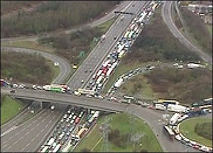
Heavy storms cause travel chaos
Heavy seas and winds of up to 80mph (128km/h) have battered parts of England, causing chaos on roads, railways and at airports and ports.
Flights at Heathrow and Gatwick airports were cancelled, speed restrictions put in place on railway lines, and roads and ports were closed.
The AA said it was on course for its busiest day of the year so far.
About 7,000 homes in south-west England were left without power due to the severe storm.
An AA spokeswoman said it was predicting to receive 16,000 call-outs during the day, compared with an average of 9,500.
She said: "As well as breakdowns, the AA is being called to deal with cars damaged by falling branches and other debris and affected by localised flooding.
"The AA is warning drivers to slow down and take extra care on the roads.
"Drivers will seriously endanger themselves and other motorists if they underestimate the power of wind gusts and drive too fast."
In West Sussex, 30 people were rescued from a caravan park after flood defences were breached.
In Cornwall, more than 30 properties in the seaside towns of Looe, Fowey, Mevagissey and Flushing were hit by wind-driven high tides.
Parts of north-east England were also hit by snowfall, with snow ploughs needed to keep some roads open.
While flood warnings in Devon and Cornwall were downgraded later on Monday, the Environment Agency said the Bristol Channel, Severn Estuary and Somerset coast remained at risk of flooding.
There were 33 flood warnings in place in England and Wales at 1600 GMT on Monday.
As forecasters warned of more to come, bulldozers were being used to build up shingle to protect the coast in Sussex and Kent.
The Environment Agency has urged people to stay away from exposed coastal areas.
Flooding caused lane closures on the M25, while the Port of Dover was forced to close, with P&O Ferries unable to operate any of its Dover-Calais sailings. It was later reopened.
BBCnews

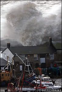
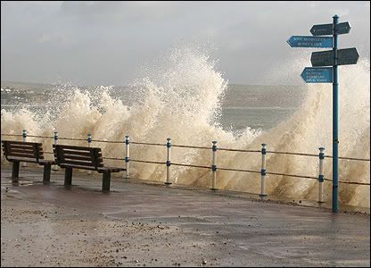
Nog een paar foto's.
Golven, verkeerschaos en sneeuw...
Large waves created by storm conditions crashed over buildings at high tide at Lyme Regis, in Dorset.
The bad weather caused problems for drivers on the old Severn Bridge, where traffic was gridlocked.
High winds and heavy snow meant treacherous conditions for drivers on the A66 in County Durham.
[ Bericht 0% gewijzigd door #ANONIEM op 10-03-2008 22:37:19 ]
Golven, verkeerschaos en sneeuw...
Large waves created by storm conditions crashed over buildings at high tide at Lyme Regis, in Dorset.

The bad weather caused problems for drivers on the old Severn Bridge, where traffic was gridlocked.
High winds and heavy snow meant treacherous conditions for drivers on the A66 in County Durham.

[ Bericht 0% gewijzigd door #ANONIEM op 10-03-2008 22:37:19 ]
Niet van de depressie die dat weer veroorzaakte.quote:Op maandag 10 maart 2008 23:23 schreef Xenwolfie het volgende:
Krijgen wij hier woensdag dus wat van mee?
Woensdag krijgen wij een andere (nieuwe) storing langs.
De verwachting van het KNMI:
quote:dinsdag 11 maart en woensdag 12 maart 2008
Buien en morgen zeer onstuimig
Het is vandaag half tot zwaar bewolkt en de komende uren komen er nog een paar buien voor. Rond het middaguur is het overwegend droog, waarna in loop van de middag de neerslagkansen vanuit het zuidwesten weer toeneemt. De maximumtemperatuur wordt ongeveer 10 graden. De zuidwestelijke wind is matig tot vrij krachtig, 4 tot 5. Langs de kust en op het IJsselmeer is de wind, krachtig tot hard, 6 tot 7. In de loop van de avond toenemend tot stormachtig, windkracht 8. Woensdag wordt het een zeer onstuimige dag. In de (vroege) ochtend en in de middag staat er aan de kust enige tijd een westerstorm, windkracht 9. Verder komen er (zeer) zware windstoten voor. In de loop van de middag wordt het dan langzaam wat rustiger. Verder zijn er vooral in het noorden enkele buien. Het wordt ongeveer 9 graden.
dinsdag 11 maart 2008 09.51 uur
|
|