WKN Weer, Klimaat en Natuurrampen
Lees alles over het onstuimige weer op onze planeet, volg orkanen en tornado's, zie hoe vulkanen uitbarsten en hoe Moeder Aarde beeft bij een aardbeving. Alles over de verwoestende kracht van onze planeet en tal van andere natuurverschijnselen.


At least 2 dead in Missouri tornadoes
(CNN) -- Severe weather raked southwestern Missouri on Monday night, killing at least two people and leaving a path of destruction across two counties, authorities said.
A line of tornadoes shadowed Interstate 44, running from the southwest to the northeast. The storms killed an elderly woman in the Strafford area and a 53-year-old woman near Marshfield. Both towns are northeast of Springfield.
Greene County Public Information Officer Jenny Fillmer Edwards said the storms cut through the area around 6 p.m. At least 25 people were planning to spend the night in a Red Cross shelter in Strafford, Edwards said.
In Webster County, the heaviest damage was reported in Marshfield, just west of I-44, according to Webster County Sheriff's Department dispatcher Jodi Goodpaster.
The elderly woman died in the Ningua community about seven miles north of Marshfield. She said numerous other people were injured.
Storms hammered the Midwest after a day of record-high temperatures across much of the country, with tornadoes also reported or suspected in Arkansas and Oklahoma and along the Illinois-Wisconsin border, The Associated Press reported.
Sgt. Gil Benn of the Kenosha County Sheriff's Department in Wisconsin told WISN that six to eight homes were severely damaged in or near the town of Wheatland, and an unknown number of cars were blown off a nearby highway.
Aurora Medical Group facilities in the area treated 12 people for minor, storm-related injuries, WISN reported.
[ Bericht 0% gewijzigd door #ANONIEM op 08-01-2008 10:58:08 ]
Zie ook --> Weeralarm VS: Tornadoes, Floods and Stormsquote:Op dinsdag 8 januari 2008 10:57 schreef aloa het volgende:
At least 2 dead in Missouri tornadoes

quote:Op dinsdag 8 januari 2008 04:55 schreef compier het volgende:
tornado alarm gaat af, als ik nooit meer post, ben ik dood... LOL
ben je d'r nog?
jup, ik ga dus vandaag Heel de dag zeggen: I hate to say I told you so, but... I TOLD YOU SO!quote:
aangezien ik de enige ben hier die zegt: er komt vast geen tornado, en als hij komt kan ik er vrij weinig tegen doen, dus ik stress er niet om
Mijn usericon is mede mogelijk gemaakt door wonderer.
Live from Sparta MO
JOE-ES-EE!!
Live from Sparta MO
JOE-ES-EE!!
Effe een tvp, aangezien ik binnenkort op vakantie ga naar de VS.
Maak wat moois van je leven!
Je Leeft Tenslotte maar een keer!
Je Leeft Tenslotte maar een keer!

Heb ik nog zelf geopend ook.quote:Op dinsdag 8 januari 2008 11:52 schreef Frutsel het volgende:
[..]
Zie ook --> Weeralarm VS: Tornadoes, Floods and Storms

Decembersneeuw en kou in de VS, de laatste dagen warmte in de Midwest en het oosten
Tijdens de voorverkiezingen van afgelopen dinsdag in New Hampshire was het prachtig weer, uit televisiebeelden viel echter ook op te maken dat er nogal wat sneeuw lag in deze Amerikaanse staat. Het sneeuwdek is een ‘erfenis’ van de sneeuwrijkste december in onder meer de hoofdstad Concord. Daar werd na ruim 130 jaar (1876) een nieuw sneeuwrecord voor de kerstmaand gevestigd. Er viel in totaal 113 centimeter sneeuw, in 1876 bedroeg de hoeveelheid sneeuw 109 cm.
Wat verder opviel aan het VS-weer van de laatste weken, was een zeer koude periode aan het eind van het jaar in de ‘Intermountain West’ (Colorado). In Alamosa sneuvelden gedurende zes opeenvolgende dagen (27 december-1 januari) maar liefst 5 dagrecords. Op de 29ste werd -36,1º gemeten.
De laatste dagen is het vooral in de Midwest en het oosten aanmerkelijk minder koud geworden. Chicago meldde maandag met 18,3º lenteachtig weer en in het Canadese Toronto werd maandag/dinsdag 14,9 en 15,5º gemeten: op 3 januari vroor het daar nog 17,7º.
op de kaart: weerkaart VS van afgelopen dinsdag. Tussen het Bermudahoog en actief koufront boven de Midwest, wordt met een zuidwestelijke stroming warme lucht aangevoerd. Koud is het op de Plains en in het westen (Rocky Mountains).
janvissersweer
Snow Storm in the Sierras
A winter storm walloped the Sierra Nevada Mountains of California along with much of Nevada in the first week of 2008. Wind gusts of more than 100 miles per hour were reported in California, Utah, and Nevada; hundreds of miles of power lines were toppled. More than 6 feet of snow fell in parts of the mountains, and heavy rains were responsible for floods in Nevada that forced several thousand people to evacuate their homes.
This pair of images shows the snow cover in Southern California and Nevada on January 7, 2008, and December 31, 2007. Already on December 31 many of the high elevations were snow-covered, and low clouds or fog filled the San Joaquin Valley at lower left. After the big storm passed through in early January, nearly all the valleys were blanketed as well—Death Valley, the long narrow valley in bottom center of the images, is one obvious exception. Mono Lake appears to be partially ice covered.
HARTFORD, Conn. — A January thaw featuring record-breaking warmth is about to become a distant memory as a nor'easter bears down on northern New England with the potential of more than a foot of snow in parts of the region.
Heavy snow warnings were posted for most of Maine and New Hampshire and parts of Vermont were under a winter storm watch with snow expected early Monday.
In southern New Hampshire, accmulations of 8 to 14 inches of snow expected by Monday evening, while Maine's southern coast is expected to see 4 to 8 inches, said Butch Roberts of the National Weather Service.
New England Live Doppler Radar Animation
The track of the storm puts the heaviest accumulations in southern, coastal areas, but all of Maine, New Hampshire and Vermont should see at least some snow, with most of it falling during the day Monday, affecting the morning and evening commute.
Southern New England could get walloped as well. By day's end, the storm could dump up to a foot of snow in Boston and Worcester.
Cape Cod may pick up an inch or two but could also experience high winds.
In Connecticut, the National Weather Service says the powerful coastal storm will dump up to 14 inches of snow in the state by the time it moves out late Monday afternoon.
Forecasters say both the morning and afternoon rush hours will be affected as the snow piles up at a rate of 1 to 2 inches an hour through the day and visibility on the roads becomes poor.
A heavy snow warning will be in effect beginning at 9 p.m. in western parts of the state and ending 7 p.m. Monday in eastern portions. The Weather Service says the heaviest snow is expected during the day Monday.
Northern sections of Connecticut are expected to receive the most snow. Coastal areas in Fairfield, New Haven and Middlesex counties can expect 5 to 8 inches of snow, while coastal New London county will get 2 to 4 inches.
The January thaw is about to become a distant memory as the nor'easter bears down on northern New England as well.
A winter storm watch is in effect for most of Maine and New Hampshire and parts of Vermont with snow expected Monday morning.
Meteorologist Butch Roberts from the National Weather Service says southern and coastal New Hampshire will likely see to 5 to 9 inches of snow, while Maine's southern coast is expected to see 4 to 8 inches of snow.
Roberts says the track of the storm puts the heaviest accumulations in southern, coastal areas, but all of Maine, New Hampshire and Vermont should see at least some snow. (Fox)
*zucht*
Ik begon net te wennen aan minder dan anderhalve meter sneeuw naast de wegen Ligt intussen alweer 20 cm hier.
Ik begon net te wennen aan minder dan anderhalve meter sneeuw naast de wegen
"Pain is my friend. I can trust pain. I can trust pain to make my life utterly miserable."
"My brain is too smart for me."
"We don't need no education." "Yes you do, you just used a double negative."
"My brain is too smart for me."
"We don't need no education." "Yes you do, you just used a double negative."
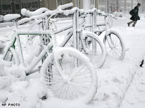
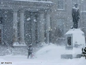
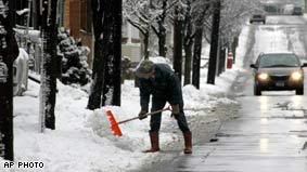
Up to 14 inches of snow to hit parts of New England
New England's first major winter storm of 2008 snarled the Monday morning commute with heavy snow and closed hundreds of schools.
Meteorologists said as much as 14 inches of snow was possible in southern New Hampshire and areas west and north of Boston.
Many communities declared snow emergencies in advance of the storm, and Boston Mayor Thomas Menino ordered only essential city employees to report to work.
Snow piled up quickly, with 11 inches by late morning at Winchendon, in north-central Massachusetts, and in South Casco, Maine, the National Weather Service said.
Pine Plains, New York, near the Connecticut state line, reported 7 inches, and Burlington, Connecticut, had 6½ inches. The Boston area had about 5.
"The story is it's a fast-moving storm," said Bill Boynton, spokesman for the New Hampshire Department of Transportation. "Not only is it limiting visibility, but it's also coming down at a pace that we can't keep up with in terms of getting bare roads."
Kaj Munic was up at 4:30 a.m. plowing the heavy, wet snow off driveways in Columbia, Connecticut. "You have to hit most places at least twice," said Munic, a 59-year-old contractor.
Hundreds of public and private schools canceled classes for the day in anticipation of the snow in Massachusetts, New Hampshire, Vermont, Maine, Connecticut, Rhode Island and parts of eastern New York.
School officials were taking no chances, especially after a December 13 storm in which many youngsters in Providence, Rhode Island, were stuck on buses for hours. That storm also caused monumental traffic jams around Boston.
More than 100 flights were canceled at Boston's Logan International Airport, as were some flights at Maine's Portland International Jetport.
"We are open, but capacity is very low because airlines made decisions yesterday and [Monday] morning to cancel many of their flights," said Phil Orlandella, a spokesman for the Massachusetts Port Authority.
The New Hampshire Legislature canceled all events.
Utilities reported scattered power outages, including a peak of more than 36,000 homes and businesses blacked out in Connecticut, said Mitch Gross, a spokesman for Connecticut Light and Power. More than 9,000 lost power in Massachusetts, and Rhode Island had a peak of more than 11,000.
"It's the issue of heavy wet snow taking down trees or tree branches, which are taking down wires," Gross said.
The snowfall was lighter than expected in some areas, with the Connecticut measurements falling short of the predicted accumulation of up to 14 inches. Initial forecasts for New York City's northern suburbs were for as much as a foot, but the metro area got mostly rain.
Authorities said major highways were slick and a number of accidents and spinouts were reported. But volume was lighter than usual as many commuters apparently heeded storm forecasts.
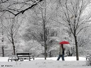
More snow on the way as New England digs out
Residents of New England awoke Tuesday to deep snow and hazardous roads after a major winter storm that caused power outages, canceled flights and gave thousands of schoolchildren a day off.
The National Weather Service reported as much as 20 inches of snow fell from the fast-moving storm Monday, which snarled the morning commute but had mostly cleared out by late afternoon.
Another round of scattered snow showers was anticipated across New England on Tuesday, with additional accumulations of up to 6 inches possible. Cold temperatures moved in behind the front sweeping through the region.
As the main storm approached Monday, hundreds of public and private schools canceled classes in Massachusetts, New Hampshire, Vermont, Maine, Connecticut, Rhode Island and eastern New York.
gehele verhaal
Het gaat goed koud worden in Amerika. Zie kaartje
Ruilen? ik ben het zatquote:
"Pain is my friend. I can trust pain. I can trust pain to make my life utterly miserable."
"My brain is too smart for me."
"We don't need no education." "Yes you do, you just used a double negative."
"My brain is too smart for me."
"We don't need no education." "Yes you do, you just used a double negative."

Als het ook maar een dag of twee zulk weer in Nederland zou zijn is het hele land in rep en roer. Voor een jaar lang.quote:Op dinsdag 15 januari 2008 22:58 schreef Jodelaar het volgende:
[..]
Beetje sneeuw en kou mag hier wel heen ja
Dan zouden ze een nieuw woord voor weeralarm moeten verzinnen want dat is een understatement dan. Ik zit te denken aan 'armageddon' ofzo.
Patience is not one of my virtues, neither is memory. Or patience for that matter.
quote:Op woensdag 16 januari 2008 13:36 schreef popolon het volgende:
[..]
Als het ook maar een dag of twee zulk weer in Nederland zou zijn is het hele land in rep en roer. Voor een jaar lang.
Dan zouden ze een nieuw woord voor weeralarm moeten verzinnen want dat is een understatement dan. Ik zit te denken aan 'armageddon' ofzo.
Ja, inderdaad. Ik weet nog die "sneeuwstorm" eind november 2005
"Pain is my friend. I can trust pain. I can trust pain to make my life utterly miserable."
"My brain is too smart for me."
"We don't need no education." "Yes you do, you just used a double negative."
"My brain is too smart for me."
"We don't need no education." "Yes you do, you just used a double negative."
Southeast snowstorm underway
Rain is sloshing up from the Gulf of Mexico while much colder air invades across the Tennessee Valley and into the Deep South. This will lead to a wintry mess with snow and sleet in central Mississippi to northern to central Alabama to north Georgia into the Carolinas.
Meanwhile moderate to heavy rain will slosh across Louisnana and Mississippi into Alabama to the Florida Panhandle and south Georgia. Locally heavy rain, perhaps between 1 and 2 inches, could impact areas from Mobile, Alabama, to Jacksonville, Florida to Charleston, South Carolina.
Along the northern edge of the rain from Jackson, Mississippi to Birmingham, Alabama, the rain will begin to mix with sleet and change over to snow before ending later Saturday.
Some sleet and then wet snow will streak over northern Georgia accumulations possible even south of Atlanta. Wet snow will also advance across Upstate South Carolina, western and northern North Carolina and then into southeast Virginia and the Delmarva area by tonight.
This could bring a general 1 to 4 inches to places such as Birmingham, Atlanta, Greenville and Charlotte. A bit heavier amounts are possible from the Raleigh area to southeast Virginia. Norfolk, Virginia, may see 3 to 6 inches as the storm exits eastward Saturday night out across the western Atlantic. Late Saturday into early Sunday the temperatures will fall below freezing so traveling on the roadways will become very dangerous as the wet snow turns to an icy mess. Use extreme caution traveling Saturday into early Sunday in the Southeast.
Gusty northwest winds and much colder temperatures will move in behind the storm system with bitterly cold temperatures overnight Saturday into early Sunday. The Upper Midwest will be brutally cold with low temperatures and dangerous wind chills through the weekend.
Wind chills will be in the 20 to 45 below zero range meaning preparation must be taken when venturing outside. Widespread wind chill advisories exist for the Dakotas, Iowa, Wisconsin, Minnesota, and parts of Illinois and Upper Michigan.
The arctic air will move into the Northeast Sunday with highs in the Northeast Corridor from Washington to Boston only in the 20s. A drop of 10-20 degrees from Friday and Saturday.
Lake-effect snow will persist downwind of the Great Lakes for the next few days with a foot or more snow possible in the favored lake belts.

-13 graden nu buiten zonder wind chill, is nog redelijk te doen, alleen je krijgt supersnel droge/chapped lippen
Mijn usericon is mede mogelijk gemaakt door wonderer.
Live from Sparta MO
JOE-ES-EE!!
Live from Sparta MO
JOE-ES-EE!!

Game-time temps could approach 'Ice Bowl' territory
GREEN BAY, Wis. -- Packers offensive linemen have a tradition of going sleeveless during games. Their resolve will be tested this evening when they face the Giants in the NFC Championship Game at Lambeau Field.
At just before noon local time, the temperature was minus-4, according to the National Weather Service. The wind chill was minus-24. Those readings will fall by kickoff, which will take place about a half hour after sundown.
The coldest postseason game in Lambeau history occurred 40 years ago, in the Packers' 21-17 legendary "Ice Bowl" victory over the Cowboys in the NFL Championship Game. The temperature at kickoff was minus-13 degrees, with a wind chill of minus-46. Tonight's game is not expected to surpass those readings, but it could come close.
Currently, the field is covered by a massive forest green tarp that's being anchored on one sideline by 11 cars and trucks, and held in place on the other by giant cement blocks. Heaters are blowing hot air beneath the tarp to keep the field from freezing.
The winds are unpredictable. One minute they have the flags on the goal posts and at the top of the stadium whipping forcefully. However, at other times the conditions appear calmer on the field.
The last time the Packers hosted the NFC Championship Game was January 1997. They defeated the Panthers 30-13. The weather conditions: 3 degrees at kickoff, with a wind chill of minus-17.
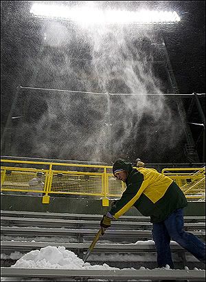
Windchill dus zo'n -40 Celsius straks bij het begin van de wedstrijd. Bikkels.
Patience is not one of my virtues, neither is memory. Or patience for that matter.
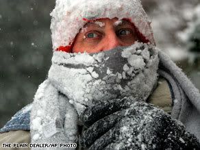
Arctic chill stretches coast to coast
(CNN)-- Bitter cold gripped most of the United States on Monday, with temperatures dipping below normal from coast to coast.
Temperatures in the Upper Midwest and Northern Plains were about 30 degrees below normal, CNN meteorologist Bonnie Schneider said.
"It's very hard to find any part of the country that's warm," Schneider said.
In Presque Isle, Maine, the overnight low dropped to 27 below zero, according to the National Weather Service. Monday's high in extreme northern Maine was not expected to make it up to zero, the service said, and the wind chill made it feel much colder. Watch the frigid forecast for Monday »
In Butte, Montana, the temperature at 10 a.m. (noon ET) was 20 below zero, up from an overnight low of 32 below.
The cold hampered firefighting efforts in Lawrence, Massachusetts, where firefighters had to deal with frozen hydrants and frigid temperatures during a seven-alarm fire.
The pre-dawn blaze destroyed a dozen homes and sent one person to a hospital, the city's fire chief said.
Firefighters in Butler County, Pennsylvania, had a similar problem, CNN affiliate WPXI-TV in Pittsburgh reported. Water sprayed on a fire turned to ice as soon as it hit the ground, creating a slipping hazard, a fire official told the station.
Icy temperatures in Fort Collins, Colorado, forced organizers to move their celebration of the Martin Luther King Jr. holiday indoors, CNN affiliate KMGH-TV in Denver reported.
Heavy lake-effect snow blanketed parts of upstate New York.
In Fulton, New York, near Syracuse, deep snow collapsed the roof of a Department of Public Works garage, according to CNN affiliate WSYR-TV in Syracuse. The people inside escaped unharmed, but snowblowers and salt trucks needed for snow removal were stuck inside the damaged building, the station reported.
More snow was in the forecast for the region -- possibly up to 12 inches.
Snow also was expected in Chicago, Illinois, and other areas near Lake Michigan. Weather was blamed for flight delays of up to an hour and 45 minutes at Chicago's O'Hare International Airport and an hour at Salt Lake City International Airport in Utah.
The National Weather Service issued a winter storm warning until 5 a.m. ET Tuesday for parts of Michigan. The service said snowfall could top 8 inches in some areas
Sneeuwstorm legt verkeer Californië lam
LOS ANGELES - Een sneeuwstorm heeft het verkeer op een belangrijke snelweg in Californië donderdag lamgelegd.
Honderden automobilisten kwamen vast te zitten in hun auto's op de Interstate 5, meldde radiostation KCBS.
Regen
In de kustregio viel veel regen. De autoriteiten waarschuwden voor overstromingen en aardverschuivingen. Het gaat vooral om de gebieden waar van de zomer bosbranden woedden en de vegetatie vernietigd werd.
nu.nl
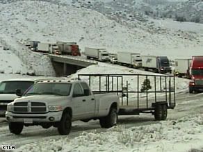
At least 300 motorists stranded in snow north of Los Angeles
LOS ANGELES, California (CNN) -- Jackknifed tractor-trailers Thursday blocked a stretch of Interstate 5 in Southern California, stranding at least 300 people on a snowy mountain pass, the California Highway Patrol said.
Emergency crews worked to open the highway for 300 to 400 vehicles traveling north and south on I-5's Tejon Pass near Gorman, said California Highway Patrol Officer Mark Ehly.
The interstate remained shut for about 40 miles south of Bakersfield to north of Santa Clarita, Ehly said.
"The biggest thing we've got right now is the ice," Ehly said. "It's really cold, and the whole freeway is just literally a skating rink."
A winter storm watch remained in effect for the region until 10 p.m. Friday, according to the National Weather Service, and another 1 to 2 feet of snow was possible above 4,000 feet, including Tejon Pass.
Driver Dave Eskildsen told CNN affiliate KTLA-TV in Los Angeles that he spent a cold night stranded in his car en route from San Diego to Oakland. "I'm just hoping I'm going to get out of here sometime soon," he said. "I left at 2 p.m. yesterday." Watch as the snow causes problems for motorists »
Eskildsen described treacherous traffic conditions during his drive into the mountains. "It was bad. It was horrible. I saw a truck slide and go off the road," he said. "I saw a couple of accidents back there."
Eskildsen said highway patrol officers were checking on motorists and distributing beverages.
Ehly, the highway patrol officer, said Red Cross workers also were passing out food. No motorists were in any danger, he said, during the long wait in six inches of newly fallen snow.
"At the summit -- it's real a climb for the vehicles," Ehly said. "The big trucks start to lose traction and they jackknife and they block two lanes ... and then essentially they've plugged up this pass."
Wendy Gardner, a pub manager in Pine Mountain Club, told The Associated Press that abandoned cars were everywhere.
"We got hit around 2:30 in the morning and it hasn't stopped," Gardner told the AP.
Ehly said he expects the massive traffic jam to end by noon Thursday at the earliest. The area hasn't had a scene such as this in about seven years, he said.
Travel through the area was "highly discouraged," the weather service said, warning of gusty winds and drifting snow that could reduce visibility to near zero.
Heavy rain played havoc in lower-lying areas of Southern California. Santa Barbara reported a record rainfall Wednesday -- 4.16 inches in 24 hours at Santa Barbara Airport, according to the National Weather Service -- smashing the old record of 2.5 inches set in 1943, the service said.
In Long Beach, rain forced 11 residents of an apartment building to find shelter elsewhere after a tarp on a roof under construction failed, according to the Long Beach Press-Telegram.
Forecasters predicted more snow and rain Thursday around Los Angeles.
Flash flooding is possible in and around areas burned in last year's devastating wildfires, the weather service said.
[ Bericht 0% gewijzigd door #ANONIEM op 24-01-2008 21:52:04 ]
LOS ANGELES - Een sneeuwstorm heeft het verkeer op een belangrijke snelweg in Californië donderdag lamgelegd.
Honderden automobilisten kwamen vast te zitten in hun auto's op de Interstate 5, meldde radiostation KCBS.
Regen
In de kustregio viel veel regen. De autoriteiten waarschuwden voor overstromingen en aardverschuivingen. Het gaat vooral om de gebieden waar van de zomer bosbranden woedden en de vegetatie vernietigd werd.
nu.nl
At least 300 motorists stranded in snow north of Los Angeles
LOS ANGELES, California (CNN) -- Jackknifed tractor-trailers Thursday blocked a stretch of Interstate 5 in Southern California, stranding at least 300 people on a snowy mountain pass, the California Highway Patrol said.
Emergency crews worked to open the highway for 300 to 400 vehicles traveling north and south on I-5's Tejon Pass near Gorman, said California Highway Patrol Officer Mark Ehly.
The interstate remained shut for about 40 miles south of Bakersfield to north of Santa Clarita, Ehly said.
"The biggest thing we've got right now is the ice," Ehly said. "It's really cold, and the whole freeway is just literally a skating rink."
A winter storm watch remained in effect for the region until 10 p.m. Friday, according to the National Weather Service, and another 1 to 2 feet of snow was possible above 4,000 feet, including Tejon Pass.
Driver Dave Eskildsen told CNN affiliate KTLA-TV in Los Angeles that he spent a cold night stranded in his car en route from San Diego to Oakland. "I'm just hoping I'm going to get out of here sometime soon," he said. "I left at 2 p.m. yesterday." Watch as the snow causes problems for motorists »
Eskildsen described treacherous traffic conditions during his drive into the mountains. "It was bad. It was horrible. I saw a truck slide and go off the road," he said. "I saw a couple of accidents back there."
Eskildsen said highway patrol officers were checking on motorists and distributing beverages.
Ehly, the highway patrol officer, said Red Cross workers also were passing out food. No motorists were in any danger, he said, during the long wait in six inches of newly fallen snow.
"At the summit -- it's real a climb for the vehicles," Ehly said. "The big trucks start to lose traction and they jackknife and they block two lanes ... and then essentially they've plugged up this pass."
Wendy Gardner, a pub manager in Pine Mountain Club, told The Associated Press that abandoned cars were everywhere.
"We got hit around 2:30 in the morning and it hasn't stopped," Gardner told the AP.
Ehly said he expects the massive traffic jam to end by noon Thursday at the earliest. The area hasn't had a scene such as this in about seven years, he said.
Travel through the area was "highly discouraged," the weather service said, warning of gusty winds and drifting snow that could reduce visibility to near zero.
Heavy rain played havoc in lower-lying areas of Southern California. Santa Barbara reported a record rainfall Wednesday -- 4.16 inches in 24 hours at Santa Barbara Airport, according to the National Weather Service -- smashing the old record of 2.5 inches set in 1943, the service said.
In Long Beach, rain forced 11 residents of an apartment building to find shelter elsewhere after a tarp on a roof under construction failed, according to the Long Beach Press-Telegram.
Forecasters predicted more snow and rain Thursday around Los Angeles.
Flash flooding is possible in and around areas burned in last year's devastating wildfires, the weather service said.
[ Bericht 0% gewijzigd door #ANONIEM op 24-01-2008 21:52:04 ]