WKN Weer, Klimaat en Natuurrampen
Lees alles over het onstuimige weer op onze planeet, volg orkanen en tornado's, zie hoe vulkanen uitbarsten en hoe Moeder Aarde beeft bij een aardbeving. Alles over de verwoestende kracht van onze planeet en tal van andere natuurverschijnselen.


Het Winterweer in de V.S.
De noordoostelijke staten van de USA
De winter in New England staat bekend als een koude winter. De wind is in het winterhalfjaar noordwestelijk en droge arctische lucht uit Canada stroomt ver naar het zuiden. Deze kou-invallen gaan soms gepaard met blizzards. Opdringende warme lucht uit het zuiden zorgt af en toe voor flinke ijzel.
Gemiddeld vriest het bij de Canadese grens in januari zo'n -13 graden. In New Jersey vriest het zo'n 5 graden. In het noordoostelijke puntje van New England daalt in januari de thermometer gemiddeld elke nacht tot -19 graden. De extremen in het gebied liegen er ook niet om. Op 19 januari werd het in Van Buren (Maine) -44,4 graden. Old Forge (New York) mat op 18 februari 1979 zelfs een minimum van -46,7 graden. Het zeewater daalt in januari en februari tot +4 graden in zowel Boston als in New York.
De zuidoostelijke staten van de USA
In de winter komt de gemiddelde kou tot Atlanta. In Maryland, Virginia, de Appalachen en de hoger gelegen staten als Kentucky vriest het veelvuldig. De ergste kou vinden we nog noordelijker in Michigan en Ontario. In West Virginia vinden we de allerlaagste temperatuur van het gebied terug. Op 30 december 1917 daalde in Lewisburg de thermometer tot -38,3 graden.
Het gebied langs de Golf van Mexico beleeft een relatief milde en korte winter. Toch kan het hier soms flink vriezen. Neem bijvoorbeeld de -28 graden die in Corinth (Mississippi) op 30 januari 1966 werd gemeten. In Florida neemt de invloed van de oceaan toe. Dit is vooral merkbaar aan de gemiddelde nachttemperatuur in het zuiden. In zeer uitzonderlijke situatie vriest het hier of valt er sneeuw. Op de Key's komt de temperatuur nooit onder nul. De allerlaagste temperatuur in Florida bedroeg -18,9 graden en werd gemeten in Tallahassee.
De staten Virginia, West Virginia en Maryland krijgen in de winter soms te maken met sneeuwstormen. Deze staan bekend als Nor'easters en komen oktober en april. Ze zijn berucht om de grote hoeveelheid sneeuw, regen en de flinke wind.
Een Nor'easter komt voor als een lagedrukgebied warme vochtige subtropische lucht uit de Golf van Mexico naar het noorden voert. De lucht wordt vermengd met vochtige lucht uit de Atlantische Oceaan. Een hogedrukgebied boven Canada biedt tegenwicht en stuwt arctische lucht naar het zuiden. Daar waar de luchtsoorten bij elkaar komen, ontstaat hevige neerslag.
De meest actieve Nor'easter is de sneeuwstorm die naar het oosten trekt en de straalstroom volgt. Vooral Washington DC, Philadelphia, New York City en Boston worden dan getroffen en krijgen grote hoeveelheden regen en sneeuw te verwerken.
Het midden van de Verenigde Staten
De winters in het noorden zijn streng. Bismarck in North Dakota heeft in januari een gemiddelde temperatuur van -12,7 graden. International Falls op de grens van Canada en Minnesota heeft zelfs een gemiddelde januari-temperatuur van -17,2 graden. De nachtelijke temperaturen bedragen hier gemiddeld -23,3 graden en de dagtemperatuur -11,2 graden.
De staten langs de Canadese grens en de Grote Meren krijgen ook in de winter vaak te maken met 'blizzards', die zeer koude lucht aanvoeren vanuit het arctische Canada. Het gebied is dan bedekt met een sneeuwlaag. Veel is dit niet. In januari valt er slechts enkele tientallen millimeters neerslag.
Veel nachten verlopen helder en de aanwezigheid van een sneeuwdek helpt mee aan een lage temperatuur. De allerlaagste temperatuur in North Dakota werd gemeten op 15 februari 1936. In Parshall werd het -51,1 graden. Op 2 februari 1996 gebeurde hetzelfde in Towar, Minnesota.
Naar het zuiden neemt de strengheid van de winter af. Tot in Kansas is de gemiddelde januaritemperatuur onder nul. In Texas loopt deze snel op. Niet alleen de zuidelijke ligging, maar ook de aanwezigheid van de Golf van Mexico speelt daarbij een rol. In Brownsville op de grens met Mexico is het in januari overdag 20,5 graden en incidenteel boven de 33 graden.
Toch krijgen relatief zuidelijk gelegen gebieden 's winters soms te maken met extreme koude situaties, doordat luchtstromen uit het hoge noorden van Canada hun weg zuidwaarts zoeken tussen de Rocky Mountains en de Appalachen. Zo was het in het ogenschijnlijk warme Texas op 3 februari 1933 in Seminole -30,6 graden.
Westen van de Verenigde Staten
In de winter heerst de meeste kou in de hoger gelegen delen van de Rocky Mountains. Arctische lucht uit Canada zorgt voor strenge winters in het noorden, zoals in Montana, Wyoming en Colorado. In Montana richt de snijdend koude wind geregeld slachtingen aan onder de veestapel. De allerlaagste temperatuur in Montana werd gemeten op 20 januari 1954. Op Rogers Pass werd het toen -56,7 graden onder nul.
In Wyoming waar ook lange strenge winters voorkomen, staat het minimumrecord op bijna -53 graden vorst. Het berggebied van Idao, Utah en Colorado is koud en sneeuwachtig. Vooral in Colorado valt veel sneeuw. Temperaturen tot onder de -50 graden zijn incidenteel mogelijk. De hoogvlakte van Nevada is eveneens koud. In Ely op 1900 meter hoogte vriest het in januari 's nachts zo'n -12,5 graden. Dit wordt tevens veroorzaakt door de vele heldere nachten in het gebied.
Warmer is het in Washington en Oregon. Het kan hier behoorlijk vriezen, maar aan zee is de winter relatief mild. De regen valt vooral tussen oktober en april. In de bergen gaat het dan om sneeuw en worden wegen afgesloten.
In het zuidwesten van Californië blijft het winters klimaat aangenaam en vriest het zelden. Het is daar dan ook regentijd. Toch kan de winter flink uithalen. Vooral in de Sierra Nevada is dat het geval. De allerlaagste temperatuur in Californië die is gemeten bedraagt -42,8 graden. In New Mexico tenslotte zijn de winters koel maar niet extreem koud.
Alaska
In de noordelijke Amerikaanse staat Alaska heersen verschillende klimaten. Zeestromingen, bergruggen en een lage zonnestand bepalen voornamelijk het klimaat. In het noorden komen poolwoestijnen voor, in het zuiden heerst een mild klimaat dat vergelijkbaar is met Nederland.
Bron:VWKWEB
De bedoeling van dit Topic is om het winterweer in de V.S. te volgen.
B.v. via onderstaande site's
Winter Weather cnn
Google News
temperatuurkaartje V.S.
temperatuurkaartje Alaska
Topic Winterweer in de V.S: Snow, Blizzards and Storms (2007)
[ Bericht 1% gewijzigd door #ANONIEM op 03-01-2008 18:21:47 (kaartje alaska toegevoegd ) ]

Qua weer is de V.S. ontzettend interessant.quote:Op woensdag 2 januari 2008 21:45 schreef ItaloDancer het volgende:
Ongelooflijk en leuk al die enorme temperatuursverschillen

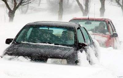
Intense snowstorm heads for New England
CONCORD, New Hampshire (AP) -- Snow fell across parts of New England for the third day in a row Wednesday, adding to last month's record accumulations and closing schools.
Flurries also extended into the Ohio Valley, and some children had an extra holiday as classes were canceled in parts of West Virginia and Ohio.
Temperatures fell to freezing levels as far south as the Florida Panhandle, and wind chill readings were below zero in parts of northern Kentucky.
Following the snowiest December on record, many areas of New Hampshire got about a foot of snow on New Year's Day, with a couple of inches added during the night and a couple more likely Wednesday. Storm totals could reach 18 inches in parts of Maine and New Hampshire and up to a foot in Vermont.
The latest snowfall in New England followed a storm on Monday that made for the area's snowiest December in decades. December's snowfall at Concord, New Hampshire, totaled 44.5 inches, toppling a record of 43 inches that had stood since 1876. Burlington, Vermont, got 45.7 inches, far above its 17.2-inch December average, and Portland, Maine, amassed 37.7 inches for its third-snowiest December on record.
"It's been unbelievable. It just keeps coming," said Bill Swain, spokesman for Maine's Sugarloaf USA ski area, which got 70 inches of snow in December.
The snowfall delayed the start of the 2008 state legislative session in Augusta, Maine, from Wednesday morning until the afternoon.
On the southern fringes of the storm on Wednesday, show was scattered from Ohio through eastern Kentucky and West Virginia into parts of Virginia and Maryland.
The heaviest snowfall was in West Virginia's rugged Randolph County, with 13 inches at Kumbrabow State Forest, the weather service said. Up to 6 inches of snow was possible at higher elevations of eastern Kentucky, although 1- to 2-inch accumulations were likely in most areas, the weather service said.
At least 40 of West Virginia's 55 counties closed all public schools Wednesday because of snow-covered roads and freezing temperatures.
Dozens of schools also were closed Wednesday in southeastern Michigan, where a six-hour burst of snow early Tuesday dumped as much as 16 inches in a three-county area north of Detroit, the weather service said.
The storm blacked out 10,000 customers Tuesday in northeast Ohio, where 15 inches of snow fell at in Pierpont, east of Cleveland. About 4,000 more lost power Tuesday evening in southwest Ohio when circuit breakers failed because of the cold. Service had been restored to nearly everyone Wednesday morning, utility officials said.
One person was killed in a weather-related traffic accident in Ohio, the Highway Patrol said.
All of Florida was under a freeze warning with temperatures expected to drop into the 20s and teens in parts of the state by Thursday morning. Northern Florida had already chilled to 30 degrees early Wednesday.
Much of Florida's prime citrus growing area was expected to get temperatures in the 20s, and Gov. Charlie Crist had signed an emergency order and relaxed restrictions in getting harvests moved to processing centers.
"Everybody's scurrying around to do what they can to protect their plants," said Terry McElroy, spokesman for the state Department of Agriculture and Consumer Services.
cnn
New Year's Snowstorm in United States
A series of holiday snowstorms blanketed the central and northeastern United States with snow in late December 2007 and early January 2008. Many places in the Northeast received more than a foot of snow in a week’s time. Several people were killed in traffic accidents, and road and air travel were interrupted across the country.
This image from the Moderate Resolution Imaging Spectroradiometer (MODIS) on NASA’s Aqua satellite shows the eastern United States on January 2, 2008, after the latest storm passed over. Two satellite overpasses have been stitched together to create the image. Snow covers the ground in the Upper Midwest, the Ohio Valley, Mid-Atlantic states West Virginia and Pennsylvania, and the Northeast. Despite a succession of December snowstorms, the temperatures had not dropped enough to freeze the Great Lakes, whose clear blue waters are overlaid with clouds. Cold air blowing southeast over the United States picks up moisture over the Gulf of Mexico (bottom center) and the Atlantic Ocean (bottom right), creating parallel ribbons of clouds.
bron:
Weeralarm voor het westen van de VS --> http://www.wrh.noaa.gov/
=================================================================
SACRAMENTO, Calif. — A fierce arctic storm lashed the California coast Friday, threatening to paralyze the mountains with deep snow and bring devastating rain to a coastal landscape already charred by wildfires.
The northern half of the state was being hit with strong rain, 85-mph wind and heavy snow in the Sierra Nevada, National Weather Service forecaster Andrew Rorke said.
In Southern California, the storm was gathering strength off the coast and was expected to strike the region by mid-afternoon, Rorke said.
We're watching it really blossom on satellite," he said.
Homeowners rushed to stack sandbags around houses lying below fire-ravaged hillsides in Southern California, while Northern California residents — like those along the Gulf Coast before a hurricane — scurried to stock up on last-minute provisions. Forecasters warned the high wind and other extreme weather would last through the weekend.
In the eastern Sierra ski town of Mammoth Lakes, resident Barbara Sholle went to the supermarket after receiving a call from the town's reverse-911 system. She waited an hour to pay for her groceries amid a crush of residents.
People were waiting in line for shopping carts," she said.
The storm system began dumping rain and snow Thursday in parts of Northern California. Power outages, damaged electrical lines and downed trees were reported in the Sacramento area by nightfall.
The U.S. Forest Service issued an avalanche warning for Mount Shasta, in the Cascade Range in far Northern California, while the National Weather Service issued a rare blizzard advisory for the Sierra Nevada.
The storm system brought high wind warnings along the coast. Ocean tides were expected to swell to 30 feet, leading the Coast Guard to caution boaters to remain in port.
"If you don't have to go out this weekend, it might be a nice weekend to stay at home after the holidays," said Frank McCarton, chief deputy director of the California Office of Emergency Services.
A rare blizzard warning for the mountains and Lake Tahoe region remained in effect until Saturday morning, and chains or snow tires were required on all vehicles in mountain passes. Forecasters said several feet of snow was expected, along with winds gusting to 150 mph and zero visibility.
"It's been several years since we've seen a storm this impressive," said Chris Jordan, a meteorologist with the National Weather Service in Reno, Nev.
As the storms barreled into the West, forecasters were expecting a freeze in the East to subside. After a freezing day virtually everywhere east of the Mississippi River, temperatures in the East were to climb Friday.
Florida's citrus growers might have been spared major damage from the cold snap, which produced flurries in the Daytona Beach area, but it will be Saturday or later before strawberry farmers know the extent of their losses.
Plant City farmer Carl Grooms surveyed his fields Thursday afternoon and spotted numerous plants with berry damage. It was a sight he suspected other farmers east of Tampa witnessed in their fields hours after temperatures dropped below freezing.
"If I've got damage, I'm sure they do too," Grooms said. But his plants seemed intact, preserving hopes that his fields would bounce back.
A serious freeze would have been devastating to the Florida's citrus trees, already struggling from years of diseases and hurricanes. But most groves are in central and South Florida, where temperatures hovered in high 20s and low 30s. Trees can be ruined when temperatures fall to 28 degrees for four hours.
"It could have been far, far worse," said Terry McElroy, a spokesman for the state Department of Agriculture and Consumer Services.
http://www.foxnews.com/story/0,2933,320189,00.html
Tell me about it  Ik zit dus in hetzelfde Concord als dat nieuwsbericht en gisteravond vroren mijn neusharen vast toen ik 's avonds buiten kwam (-22 C). Er ligt een centimeter of vijftig sneeuw in de achtertuin en de bergen aan weerszijden van de oprit zijn nu bijna twee meter hoog.
Voor wat plaatjes: http://gallery.nietoverdrijven.com/thumbnails.php?album=27 Wordt nog regelmatig geupdate, dat winterweer blijft wel even aanwezig.
Een paar jaar geleden zat ik in januari in Potsdam, New York, toen vroor het op een nacht 40 graden. Het is een vreemde gewaarwording hoor, zo koud.
Voor wat plaatjes: http://gallery.nietoverdrijven.com/thumbnails.php?album=27
Een paar jaar geleden zat ik in januari in Potsdam, New York, toen vroor het op een nacht 40 graden. Het is een vreemde gewaarwording hoor, zo koud.
"Pain is my friend. I can trust pain. I can trust pain to make my life utterly miserable."
"My brain is too smart for me."
"We don't need no education." "Yes you do, you just used a double negative."
"My brain is too smart for me."
"We don't need no education." "Yes you do, you just used a double negative."
t wordt tijd voor wat chartervluchtjes richting Aspen en Winter Park
Minister Cramer: "Milieuvervuiling mag zolang je maar betaalt."
Minister Cramer: "Mensheid in 2100 grotendeels verdwenen."
Minister Cramer: "In 2050 40% van alle dier- en plantensoorten uitgestorven."
Minister Cramer: "Mensheid in 2100 grotendeels verdwenen."
Minister Cramer: "In 2050 40% van alle dier- en plantensoorten uitgestorven."
Leguanen vallen uit de boom door kou
Door de inval van de winter in Florida zijn deze week in de parken de leguanen uit de boom gevallen. De dieren waren verkleumd door de kou.
De temperatuur in het noorden van Florida is gedaald tot -7 graden. Zelfs in Tampa en Orlando vroor het. In Miami daalde de temperatuur tot +4 graden en zelfs op het altijd milde Key West was het +7,6 graden.
Door de koude hebben de dieren het er moeilijk. In parken van Miami zien voorbijgangers reptielen tegen de grond smakken. De leguanen hebben een temperatuur nodig van meer dan 23 graden Celsius en het liefst 35 graden. Door de kou verlamt hun lichaam en verliezen ze alle kracht.
Mensen proberen de dieren te verzamelen en in de zon te leggen om ze op te laten warmen. In een deel van de gevallen lukt dit. De tropische leguanen zijn geen oorspronkelijke bewoners van Zuid-Florida, maar werden ingevoerd uit Mexico en Centraal-Amerika.
vwkweb
1,2 miljoen mensen zonder stroom.
[ Bericht 5% gewijzigd door #ANONIEM op 05-01-2008 18:51:51 ]
quote:Actieve depressie ontregelt westkust VS
Het noorden van Californië is getroffen door een actieve depressie. Zware regen en sneeuwbuien in de hogere delen, zorgden ervoor dat 1,2 miljoen mensen zonder stroom kwamen te zitten.
Het zwaarst is het gebied tussen San Francisco en Sacramento getroffen. In Santa Clara County viel 250 millimeter neerslag. North Scotts Valley gaf 175 millimeter door.
In de hogere delen viel sneeuw. Timberline Lodge in Oregon meldde 86 centimeter sneeuw. In de hogere delen van Californië bleef het sneeuwdek beperkt tot 36 centimeter. Ook waren er zware windstoten in de bergen. Mount Diablo State Park en Mammoth Mountain rapporteerden een windstoot tot 176 kilometer per uur.
Het weg- en vliegverkeer raakte ontregeld door de neerslag. De autoriteiten riepen daarop de bevolking op om binnen te blijven.
vwk
[ Bericht 5% gewijzigd door #ANONIEM op 05-01-2008 18:51:51 ]
Noodtoestand in Californië na stormweer
Arnold Schwarzenegger, gouverneur van Californië heeft zaterdag de noodtoestand uitgeroepen in zijn staat nadat hevige sneeuw- en regenbuien 'extreem gevaarlijk' werden. Honderdduizenden mensen kwamen zonder stroom te zitten nadat rukwinden de stroommasten hadden vernield. Metershoge sneeuw blokkeerde het verkeer in Sierra Nevada.
Arnold Schwarzenegger, gouverneur van Californië heeft zaterdag de noodtoestand uitgeroepen in zijn staat nadat hevige sneeuw- en regenbuien 'extreem gevaarlijk' werden. Honderdduizenden mensen kwamen zonder stroom te zitten nadat rukwinden de stroommasten hadden vernield. Metershoge sneeuw blokkeerde het verkeer in Sierra Nevada.
quote:Californië getroffen door zware storm
Bron : Nieuws
(Novum/AP) - De Amerikaanse oostkust en met name de staat Californië gaan dit weekeinde gebukt onder een extreem zware winterse storm. Bijna een half miljoen mensen kwamen zonder stroom te zitten. In de bergen van de Sierra Nevada wordt een pak sneeuw van drie meter verwacht.
Het gebied kreeg vrijdag al te maken met veel neerslag en windstoten tot 130 kilometer per uur. Vrachtwagens waaiden om en auto's, huizen en wegen liepen schade op door omvallende bomen. Op plaatsen in het zuiden van Californië, waar weinig begroeiing is vanwege de hevige bosbranden van afgelopen zomer, werden bewoners uit vrees voor aardverschuivingen geadviseerd binnen te blijven.
Veel reizigers zijn door het noodweer gestrand. Hooggelegen wegen zijn afgesloten en het Rode Kruis heeft een opvang ingericht voor zo'n tweehonderd gestrande automobilisten. Op de luchthaven van San Francisco werden vliegtuigen aan de grond gehouden. Voor zondag is een nieuw front voorspeld met nog meer neerslag.
[Copyright 2008, Novum]
Prachtig weer. Ik zou er wat voor over hebben als dat naar hier zou komen.
Haha, U schakelt nog. Test een DAF !
Was maar even een dipje van 2 dagen hoor, geen invallende winter. Nachttemperatuur in Zuid Florida ligt weer gewoon rond de 20graden, overdagen midden tot hoge 20'ers. Noord FL krabbelt de temperatuur ook weer op. (gelukkig!)quote:Op zaterdag 5 januari 2008 11:15 schreef aloa het volgende:
Leguanen vallen uit de boom door kou
Door de inval van de winter in Florida zijn deze week in de parken de leguanen uit de boom gevallen. De dieren waren verkleumd door de kou.
De temperatuur in het noorden van Florida is gedaald tot -7 graden. Zelfs in Tampa en Orlando vroor het. In Miami daalde de temperatuur tot +4 graden en zelfs op het altijd milde Key West was het +7,6 graden.
Door de koude hebben de dieren het er moeilijk. In parken van Miami zien voorbijgangers reptielen tegen de grond smakken. De leguanen hebben een temperatuur nodig van meer dan 23 graden Celsius en het liefst 35 graden. Door de kou verlamt hun lichaam en verliezen ze alle kracht.
vwkweb
The black and white you'll never pass, stick yer blue flag up yer arse!
'They know on the Continent that European football without the English is like a hot dog without the mustard' Sir Bobby Charlton
'They know on the Continent that European football without the English is like a hot dog without the mustard' Sir Bobby Charlton
Californië getroffen door zware stormBron : Nieuws
(Novum/AP) - De Amerikaanse oostkust en met name de staat Californië
Volgens mij ligt Californie toch echt aan de westkust
(Novum/AP) - De Amerikaanse oostkust en met name de staat Californië
Volgens mij ligt Californie toch echt aan de westkust
And the young, they can lose hope cause they can't see beyond today,. ..
The wisdom that the old can't give away
The wisdom that the old can't give away
Monster Arctic Storm Pummels California, Threatens Mudslides, Cuts Power
SANTA ANA, Calif. — A levee break flooded hundreds of homes Saturday as the storm that has pummeled the West Coast with high wind and heavy rain dropped a thick blanket of snow on the Sierra Nevada on Saturday.
Thousands of people had no power in three states and thousands more had been told to leave their homes in mudslide-prone areas of Southern California.
Up to 44 inches of snow had fallen in some parts of the Sierra Nevada, the National Weather Service said Saturday morning. Forecasters expected the storm to dump as much as 10 feet at higher elevations of the mountain range by Sunday.
East of the Sierra in Nevada's Lyon County, a levee broke early Saturday along an agricultural canal, releasing water as much as 3 feet deep into the town of Fernley and stranding about 3,500 people, authorities said. Rescuers were using school buses, boats and helicopters.
No injuries were reported.
http://www.foxnews.com/story/0,2933,320189,00.html
SANTA ANA, Calif. — A levee break flooded hundreds of homes Saturday as the storm that has pummeled the West Coast with high wind and heavy rain dropped a thick blanket of snow on the Sierra Nevada on Saturday.
Thousands of people had no power in three states and thousands more had been told to leave their homes in mudslide-prone areas of Southern California.
Up to 44 inches of snow had fallen in some parts of the Sierra Nevada, the National Weather Service said Saturday morning. Forecasters expected the storm to dump as much as 10 feet at higher elevations of the mountain range by Sunday.
East of the Sierra in Nevada's Lyon County, a levee broke early Saturday along an agricultural canal, releasing water as much as 3 feet deep into the town of Fernley and stranding about 3,500 people, authorities said. Rescuers were using school buses, boats and helicopters.
No injuries were reported.


http://www.foxnews.com/story/0,2933,320189,00.html
Tja, zo'n boom in je huis is hier niet zodanig mogelijk als in Amerika. Daar knutselen ze nog huizen in elkaar van plankjes hout in plaats van fatsoenlijke stenen.
Haha, U schakelt nog. Test een DAF !
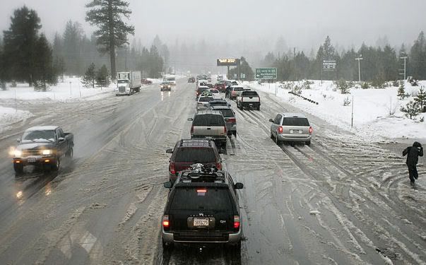
VS geteisterd door winterstorm
Sinds vrijdag houdt een winterstorm huis in de zuidwestelijke staten van de VS. De combinatie van harde wind en sneeuwval bracht veel mensen in de problemen.
De storm die sinds vrijdag over het westen van de Verenigde Staten raast, heeft zaterdag voor overstromingen gezorgd in de staat Nevada. Een paar duizend mensen strandden nadat een dijk was doorgebroken en ijskoud kanaalwater drie- tot vierhonderd huizen instroomde, aldus Amerikaanse media.
De storm, met windsnelheden tot 160 kilometer per uur, is inmiddels over het hoogtepunt heen, maar weet al twee dagen voor chaos te zorgen in Californië en omliggende staten. In die staat eiste het noodweer tot nog toe een leven. De harde wind, omgevallen bomen en sneeuwval hebben ervoor gezorgd dat ten minste 440.000 mensen langs de Amerikaanse westkust zaterdagmiddag zonder stroom zaten.
De autoriteiten hebben circa drieduizend mensen in het zuiden van Californië gevraagd hun huizen te verlaten omdat in hun omgeving modderstromen dreigen. Door hevige bosbranden in oktober kwamen hellingen in onder meer Orange County bloot te liggen. Daardoor kan de met regenwater verzadigde bodem makkelijk gaan schuiven.
Ook morgen valt er nog sneeuw in het zuidwesten van de Verenigde Staten. De storm trekt landinwaarts en zwakt in kracht af. Na dinsdag komt een nieuwe storing vanuit het westen opzetten. Deze lijkt vooralsnog vooral in het noordwesten voor neerslag te zorgen en brengt zachtere lucht naar de westkust van de VS.
weeronline.nl
Mijn usericon is mede mogelijk gemaakt door wonderer.
Live from Sparta MO
JOE-ES-EE!!
Live from Sparta MO
JOE-ES-EE!!
Aan de westkust van Michigan ook diverse tornado waarschuwingen, je kijkt er eigenlijk al niet meer van op.
Tot twee dagen geleden veel sneeuw en kou en vandaag is alle sneeuw weg. 't Was 16 graden. Van 't weekend duikt het weer onder nul met weer sneeuwstormen.
't Plaatje op de lokale weersite ziet er dan zo uit:
Tot twee dagen geleden veel sneeuw en kou en vandaag is alle sneeuw weg. 't Was 16 graden.
't Plaatje op de lokale weersite ziet er dan zo uit:

Patience is not one of my virtues, neither is memory. Or patience for that matter.
tornado alarm gaat af, als ik nooit meer post, ben ik dood... LOL
Mijn usericon is mede mogelijk gemaakt door wonderer.
Live from Sparta MO
JOE-ES-EE!!
Live from Sparta MO
JOE-ES-EE!!
At least 2 dead in Missouri tornadoes
(CNN) -- Severe weather raked southwestern Missouri on Monday night, killing at least two people and leaving a path of destruction across two counties, authorities said.
A line of tornadoes shadowed Interstate 44, running from the southwest to the northeast. The storms killed an elderly woman in the Strafford area and a 53-year-old woman near Marshfield. Both towns are northeast of Springfield.
Greene County Public Information Officer Jenny Fillmer Edwards said the storms cut through the area around 6 p.m. At least 25 people were planning to spend the night in a Red Cross shelter in Strafford, Edwards said.
In Webster County, the heaviest damage was reported in Marshfield, just west of I-44, according to Webster County Sheriff's Department dispatcher Jodi Goodpaster.
The elderly woman died in the Ningua community about seven miles north of Marshfield. She said numerous other people were injured.
Storms hammered the Midwest after a day of record-high temperatures across much of the country, with tornadoes also reported or suspected in Arkansas and Oklahoma and along the Illinois-Wisconsin border, The Associated Press reported.
Sgt. Gil Benn of the Kenosha County Sheriff's Department in Wisconsin told WISN that six to eight homes were severely damaged in or near the town of Wheatland, and an unknown number of cars were blown off a nearby highway.
Aurora Medical Group facilities in the area treated 12 people for minor, storm-related injuries, WISN reported.
[ Bericht 0% gewijzigd door #ANONIEM op 08-01-2008 10:58:08 ]
Zie ook --> Weeralarm VS: Tornadoes, Floods and Stormsquote:Op dinsdag 8 januari 2008 10:57 schreef aloa het volgende:
At least 2 dead in Missouri tornadoes

quote:Op dinsdag 8 januari 2008 04:55 schreef compier het volgende:
tornado alarm gaat af, als ik nooit meer post, ben ik dood... LOL
ben je d'r nog?
jup, ik ga dus vandaag Heel de dag zeggen: I hate to say I told you so, but... I TOLD YOU SO!quote:
aangezien ik de enige ben hier die zegt: er komt vast geen tornado, en als hij komt kan ik er vrij weinig tegen doen, dus ik stress er niet om
Mijn usericon is mede mogelijk gemaakt door wonderer.
Live from Sparta MO
JOE-ES-EE!!
Live from Sparta MO
JOE-ES-EE!!
Effe een tvp, aangezien ik binnenkort op vakantie ga naar de VS.
Maak wat moois van je leven!
Je Leeft Tenslotte maar een keer!
Je Leeft Tenslotte maar een keer!

Heb ik nog zelf geopend ook.quote:Op dinsdag 8 januari 2008 11:52 schreef Frutsel het volgende:
[..]
Zie ook --> Weeralarm VS: Tornadoes, Floods and Storms
Decembersneeuw en kou in de VS, de laatste dagen warmte in de Midwest en het oosten
Tijdens de voorverkiezingen van afgelopen dinsdag in New Hampshire was het prachtig weer, uit televisiebeelden viel echter ook op te maken dat er nogal wat sneeuw lag in deze Amerikaanse staat. Het sneeuwdek is een ‘erfenis’ van de sneeuwrijkste december in onder meer de hoofdstad Concord. Daar werd na ruim 130 jaar (1876) een nieuw sneeuwrecord voor de kerstmaand gevestigd. Er viel in totaal 113 centimeter sneeuw, in 1876 bedroeg de hoeveelheid sneeuw 109 cm.
Wat verder opviel aan het VS-weer van de laatste weken, was een zeer koude periode aan het eind van het jaar in de ‘Intermountain West’ (Colorado). In Alamosa sneuvelden gedurende zes opeenvolgende dagen (27 december-1 januari) maar liefst 5 dagrecords. Op de 29ste werd -36,1º gemeten.
De laatste dagen is het vooral in de Midwest en het oosten aanmerkelijk minder koud geworden. Chicago meldde maandag met 18,3º lenteachtig weer en in het Canadese Toronto werd maandag/dinsdag 14,9 en 15,5º gemeten: op 3 januari vroor het daar nog 17,7º.
op de kaart: weerkaart VS van afgelopen dinsdag. Tussen het Bermudahoog en actief koufront boven de Midwest, wordt met een zuidwestelijke stroming warme lucht aangevoerd. Koud is het op de Plains en in het westen (Rocky Mountains).
janvissersweer
Snow Storm in the Sierras
A winter storm walloped the Sierra Nevada Mountains of California along with much of Nevada in the first week of 2008. Wind gusts of more than 100 miles per hour were reported in California, Utah, and Nevada; hundreds of miles of power lines were toppled. More than 6 feet of snow fell in parts of the mountains, and heavy rains were responsible for floods in Nevada that forced several thousand people to evacuate their homes.
This pair of images shows the snow cover in Southern California and Nevada on January 7, 2008, and December 31, 2007. Already on December 31 many of the high elevations were snow-covered, and low clouds or fog filled the San Joaquin Valley at lower left. After the big storm passed through in early January, nearly all the valleys were blanketed as well—Death Valley, the long narrow valley in bottom center of the images, is one obvious exception. Mono Lake appears to be partially ice covered.
HARTFORD, Conn. — A January thaw featuring record-breaking warmth is about to become a distant memory as a nor'easter bears down on northern New England with the potential of more than a foot of snow in parts of the region.
Heavy snow warnings were posted for most of Maine and New Hampshire and parts of Vermont were under a winter storm watch with snow expected early Monday.
In southern New Hampshire, accmulations of 8 to 14 inches of snow expected by Monday evening, while Maine's southern coast is expected to see 4 to 8 inches, said Butch Roberts of the National Weather Service.
New England Live Doppler Radar Animation
The track of the storm puts the heaviest accumulations in southern, coastal areas, but all of Maine, New Hampshire and Vermont should see at least some snow, with most of it falling during the day Monday, affecting the morning and evening commute.
Southern New England could get walloped as well. By day's end, the storm could dump up to a foot of snow in Boston and Worcester.
Cape Cod may pick up an inch or two but could also experience high winds.
In Connecticut, the National Weather Service says the powerful coastal storm will dump up to 14 inches of snow in the state by the time it moves out late Monday afternoon.
Forecasters say both the morning and afternoon rush hours will be affected as the snow piles up at a rate of 1 to 2 inches an hour through the day and visibility on the roads becomes poor.
A heavy snow warning will be in effect beginning at 9 p.m. in western parts of the state and ending 7 p.m. Monday in eastern portions. The Weather Service says the heaviest snow is expected during the day Monday.
Northern sections of Connecticut are expected to receive the most snow. Coastal areas in Fairfield, New Haven and Middlesex counties can expect 5 to 8 inches of snow, while coastal New London county will get 2 to 4 inches.
The January thaw is about to become a distant memory as the nor'easter bears down on northern New England as well.
A winter storm watch is in effect for most of Maine and New Hampshire and parts of Vermont with snow expected Monday morning.
Meteorologist Butch Roberts from the National Weather Service says southern and coastal New Hampshire will likely see to 5 to 9 inches of snow, while Maine's southern coast is expected to see 4 to 8 inches of snow.
Roberts says the track of the storm puts the heaviest accumulations in southern, coastal areas, but all of Maine, New Hampshire and Vermont should see at least some snow. (Fox)
*zucht*
Ik begon net te wennen aan minder dan anderhalve meter sneeuw naast de wegen Ligt intussen alweer 20 cm hier.
Ik begon net te wennen aan minder dan anderhalve meter sneeuw naast de wegen
"Pain is my friend. I can trust pain. I can trust pain to make my life utterly miserable."
"My brain is too smart for me."
"We don't need no education." "Yes you do, you just used a double negative."
"My brain is too smart for me."
"We don't need no education." "Yes you do, you just used a double negative."
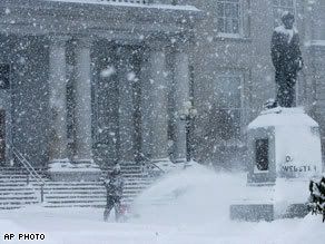
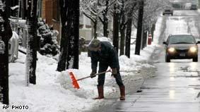
Up to 14 inches of snow to hit parts of New England
New England's first major winter storm of 2008 snarled the Monday morning commute with heavy snow and closed hundreds of schools.
Meteorologists said as much as 14 inches of snow was possible in southern New Hampshire and areas west and north of Boston.
Many communities declared snow emergencies in advance of the storm, and Boston Mayor Thomas Menino ordered only essential city employees to report to work.
Snow piled up quickly, with 11 inches by late morning at Winchendon, in north-central Massachusetts, and in South Casco, Maine, the National Weather Service said.
Pine Plains, New York, near the Connecticut state line, reported 7 inches, and Burlington, Connecticut, had 6½ inches. The Boston area had about 5.
"The story is it's a fast-moving storm," said Bill Boynton, spokesman for the New Hampshire Department of Transportation. "Not only is it limiting visibility, but it's also coming down at a pace that we can't keep up with in terms of getting bare roads."
Kaj Munic was up at 4:30 a.m. plowing the heavy, wet snow off driveways in Columbia, Connecticut. "You have to hit most places at least twice," said Munic, a 59-year-old contractor.
Hundreds of public and private schools canceled classes for the day in anticipation of the snow in Massachusetts, New Hampshire, Vermont, Maine, Connecticut, Rhode Island and parts of eastern New York.
School officials were taking no chances, especially after a December 13 storm in which many youngsters in Providence, Rhode Island, were stuck on buses for hours. That storm also caused monumental traffic jams around Boston.
More than 100 flights were canceled at Boston's Logan International Airport, as were some flights at Maine's Portland International Jetport.
"We are open, but capacity is very low because airlines made decisions yesterday and [Monday] morning to cancel many of their flights," said Phil Orlandella, a spokesman for the Massachusetts Port Authority.
The New Hampshire Legislature canceled all events.
Utilities reported scattered power outages, including a peak of more than 36,000 homes and businesses blacked out in Connecticut, said Mitch Gross, a spokesman for Connecticut Light and Power. More than 9,000 lost power in Massachusetts, and Rhode Island had a peak of more than 11,000.
"It's the issue of heavy wet snow taking down trees or tree branches, which are taking down wires," Gross said.
The snowfall was lighter than expected in some areas, with the Connecticut measurements falling short of the predicted accumulation of up to 14 inches. Initial forecasts for New York City's northern suburbs were for as much as a foot, but the metro area got mostly rain.
Authorities said major highways were slick and a number of accidents and spinouts were reported. But volume was lighter than usual as many commuters apparently heeded storm forecasts.
More snow on the way as New England digs out
Residents of New England awoke Tuesday to deep snow and hazardous roads after a major winter storm that caused power outages, canceled flights and gave thousands of schoolchildren a day off.
The National Weather Service reported as much as 20 inches of snow fell from the fast-moving storm Monday, which snarled the morning commute but had mostly cleared out by late afternoon.
Another round of scattered snow showers was anticipated across New England on Tuesday, with additional accumulations of up to 6 inches possible. Cold temperatures moved in behind the front sweeping through the region.
As the main storm approached Monday, hundreds of public and private schools canceled classes in Massachusetts, New Hampshire, Vermont, Maine, Connecticut, Rhode Island and eastern New York.
gehele verhaal
Het gaat goed koud worden in Amerika. Zie kaartje
Ruilen? ik ben het zatquote:
"Pain is my friend. I can trust pain. I can trust pain to make my life utterly miserable."
"My brain is too smart for me."
"We don't need no education." "Yes you do, you just used a double negative."
"My brain is too smart for me."
"We don't need no education." "Yes you do, you just used a double negative."

Als het ook maar een dag of twee zulk weer in Nederland zou zijn is het hele land in rep en roer. Voor een jaar lang.quote:Op dinsdag 15 januari 2008 22:58 schreef Jodelaar het volgende:
[..]
Beetje sneeuw en kou mag hier wel heen ja
Dan zouden ze een nieuw woord voor weeralarm moeten verzinnen want dat is een understatement dan. Ik zit te denken aan 'armageddon' ofzo.
Patience is not one of my virtues, neither is memory. Or patience for that matter.
quote:Op woensdag 16 januari 2008 13:36 schreef popolon het volgende:
[..]
Als het ook maar een dag of twee zulk weer in Nederland zou zijn is het hele land in rep en roer. Voor een jaar lang.
Dan zouden ze een nieuw woord voor weeralarm moeten verzinnen want dat is een understatement dan. Ik zit te denken aan 'armageddon' ofzo.
Ja, inderdaad. Ik weet nog die "sneeuwstorm" eind november 2005
"Pain is my friend. I can trust pain. I can trust pain to make my life utterly miserable."
"My brain is too smart for me."
"We don't need no education." "Yes you do, you just used a double negative."
"My brain is too smart for me."
"We don't need no education." "Yes you do, you just used a double negative."
Southeast snowstorm underway
Rain is sloshing up from the Gulf of Mexico while much colder air invades across the Tennessee Valley and into the Deep South. This will lead to a wintry mess with snow and sleet in central Mississippi to northern to central Alabama to north Georgia into the Carolinas.
Meanwhile moderate to heavy rain will slosh across Louisnana and Mississippi into Alabama to the Florida Panhandle and south Georgia. Locally heavy rain, perhaps between 1 and 2 inches, could impact areas from Mobile, Alabama, to Jacksonville, Florida to Charleston, South Carolina.
Along the northern edge of the rain from Jackson, Mississippi to Birmingham, Alabama, the rain will begin to mix with sleet and change over to snow before ending later Saturday.
Some sleet and then wet snow will streak over northern Georgia accumulations possible even south of Atlanta. Wet snow will also advance across Upstate South Carolina, western and northern North Carolina and then into southeast Virginia and the Delmarva area by tonight.
This could bring a general 1 to 4 inches to places such as Birmingham, Atlanta, Greenville and Charlotte. A bit heavier amounts are possible from the Raleigh area to southeast Virginia. Norfolk, Virginia, may see 3 to 6 inches as the storm exits eastward Saturday night out across the western Atlantic. Late Saturday into early Sunday the temperatures will fall below freezing so traveling on the roadways will become very dangerous as the wet snow turns to an icy mess. Use extreme caution traveling Saturday into early Sunday in the Southeast.
Gusty northwest winds and much colder temperatures will move in behind the storm system with bitterly cold temperatures overnight Saturday into early Sunday. The Upper Midwest will be brutally cold with low temperatures and dangerous wind chills through the weekend.
Wind chills will be in the 20 to 45 below zero range meaning preparation must be taken when venturing outside. Widespread wind chill advisories exist for the Dakotas, Iowa, Wisconsin, Minnesota, and parts of Illinois and Upper Michigan.
The arctic air will move into the Northeast Sunday with highs in the Northeast Corridor from Washington to Boston only in the 20s. A drop of 10-20 degrees from Friday and Saturday.
Lake-effect snow will persist downwind of the Great Lakes for the next few days with a foot or more snow possible in the favored lake belts.

-13 graden nu buiten zonder wind chill, is nog redelijk te doen, alleen je krijgt supersnel droge/chapped lippen
Mijn usericon is mede mogelijk gemaakt door wonderer.
Live from Sparta MO
JOE-ES-EE!!
Live from Sparta MO
JOE-ES-EE!!

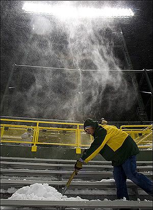
Game-time temps could approach 'Ice Bowl' territory
GREEN BAY, Wis. -- Packers offensive linemen have a tradition of going sleeveless during games. Their resolve will be tested this evening when they face the Giants in the NFC Championship Game at Lambeau Field.
At just before noon local time, the temperature was minus-4, according to the National Weather Service. The wind chill was minus-24. Those readings will fall by kickoff, which will take place about a half hour after sundown.
The coldest postseason game in Lambeau history occurred 40 years ago, in the Packers' 21-17 legendary "Ice Bowl" victory over the Cowboys in the NFL Championship Game. The temperature at kickoff was minus-13 degrees, with a wind chill of minus-46. Tonight's game is not expected to surpass those readings, but it could come close.
Currently, the field is covered by a massive forest green tarp that's being anchored on one sideline by 11 cars and trucks, and held in place on the other by giant cement blocks. Heaters are blowing hot air beneath the tarp to keep the field from freezing.
The winds are unpredictable. One minute they have the flags on the goal posts and at the top of the stadium whipping forcefully. However, at other times the conditions appear calmer on the field.
The last time the Packers hosted the NFC Championship Game was January 1997. They defeated the Panthers 30-13. The weather conditions: 3 degrees at kickoff, with a wind chill of minus-17.
Windchill dus zo'n -40 Celsius straks bij het begin van de wedstrijd. Bikkels.
Patience is not one of my virtues, neither is memory. Or patience for that matter.
Arctic chill stretches coast to coast
(CNN)-- Bitter cold gripped most of the United States on Monday, with temperatures dipping below normal from coast to coast.
Temperatures in the Upper Midwest and Northern Plains were about 30 degrees below normal, CNN meteorologist Bonnie Schneider said.
"It's very hard to find any part of the country that's warm," Schneider said.
In Presque Isle, Maine, the overnight low dropped to 27 below zero, according to the National Weather Service. Monday's high in extreme northern Maine was not expected to make it up to zero, the service said, and the wind chill made it feel much colder. Watch the frigid forecast for Monday »
In Butte, Montana, the temperature at 10 a.m. (noon ET) was 20 below zero, up from an overnight low of 32 below.
The cold hampered firefighting efforts in Lawrence, Massachusetts, where firefighters had to deal with frozen hydrants and frigid temperatures during a seven-alarm fire.
The pre-dawn blaze destroyed a dozen homes and sent one person to a hospital, the city's fire chief said.
Firefighters in Butler County, Pennsylvania, had a similar problem, CNN affiliate WPXI-TV in Pittsburgh reported. Water sprayed on a fire turned to ice as soon as it hit the ground, creating a slipping hazard, a fire official told the station.
Icy temperatures in Fort Collins, Colorado, forced organizers to move their celebration of the Martin Luther King Jr. holiday indoors, CNN affiliate KMGH-TV in Denver reported.
Heavy lake-effect snow blanketed parts of upstate New York.
In Fulton, New York, near Syracuse, deep snow collapsed the roof of a Department of Public Works garage, according to CNN affiliate WSYR-TV in Syracuse. The people inside escaped unharmed, but snowblowers and salt trucks needed for snow removal were stuck inside the damaged building, the station reported.
More snow was in the forecast for the region -- possibly up to 12 inches.
Snow also was expected in Chicago, Illinois, and other areas near Lake Michigan. Weather was blamed for flight delays of up to an hour and 45 minutes at Chicago's O'Hare International Airport and an hour at Salt Lake City International Airport in Utah.
The National Weather Service issued a winter storm warning until 5 a.m. ET Tuesday for parts of Michigan. The service said snowfall could top 8 inches in some areas
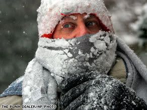
Sneeuwstorm legt verkeer Californië lam
LOS ANGELES - Een sneeuwstorm heeft het verkeer op een belangrijke snelweg in Californië donderdag lamgelegd.
Honderden automobilisten kwamen vast te zitten in hun auto's op de Interstate 5, meldde radiostation KCBS.
Regen
In de kustregio viel veel regen. De autoriteiten waarschuwden voor overstromingen en aardverschuivingen. Het gaat vooral om de gebieden waar van de zomer bosbranden woedden en de vegetatie vernietigd werd.
nu.nl
At least 300 motorists stranded in snow north of Los Angeles
LOS ANGELES, California (CNN) -- Jackknifed tractor-trailers Thursday blocked a stretch of Interstate 5 in Southern California, stranding at least 300 people on a snowy mountain pass, the California Highway Patrol said.
Emergency crews worked to open the highway for 300 to 400 vehicles traveling north and south on I-5's Tejon Pass near Gorman, said California Highway Patrol Officer Mark Ehly.
The interstate remained shut for about 40 miles south of Bakersfield to north of Santa Clarita, Ehly said.
"The biggest thing we've got right now is the ice," Ehly said. "It's really cold, and the whole freeway is just literally a skating rink."
A winter storm watch remained in effect for the region until 10 p.m. Friday, according to the National Weather Service, and another 1 to 2 feet of snow was possible above 4,000 feet, including Tejon Pass.
Driver Dave Eskildsen told CNN affiliate KTLA-TV in Los Angeles that he spent a cold night stranded in his car en route from San Diego to Oakland. "I'm just hoping I'm going to get out of here sometime soon," he said. "I left at 2 p.m. yesterday." Watch as the snow causes problems for motorists »
Eskildsen described treacherous traffic conditions during his drive into the mountains. "It was bad. It was horrible. I saw a truck slide and go off the road," he said. "I saw a couple of accidents back there."
Eskildsen said highway patrol officers were checking on motorists and distributing beverages.
Ehly, the highway patrol officer, said Red Cross workers also were passing out food. No motorists were in any danger, he said, during the long wait in six inches of newly fallen snow.
"At the summit -- it's real a climb for the vehicles," Ehly said. "The big trucks start to lose traction and they jackknife and they block two lanes ... and then essentially they've plugged up this pass."
Wendy Gardner, a pub manager in Pine Mountain Club, told The Associated Press that abandoned cars were everywhere.
"We got hit around 2:30 in the morning and it hasn't stopped," Gardner told the AP.
Ehly said he expects the massive traffic jam to end by noon Thursday at the earliest. The area hasn't had a scene such as this in about seven years, he said.
Travel through the area was "highly discouraged," the weather service said, warning of gusty winds and drifting snow that could reduce visibility to near zero.
Heavy rain played havoc in lower-lying areas of Southern California. Santa Barbara reported a record rainfall Wednesday -- 4.16 inches in 24 hours at Santa Barbara Airport, according to the National Weather Service -- smashing the old record of 2.5 inches set in 1943, the service said.
In Long Beach, rain forced 11 residents of an apartment building to find shelter elsewhere after a tarp on a roof under construction failed, according to the Long Beach Press-Telegram.
Forecasters predicted more snow and rain Thursday around Los Angeles.
Flash flooding is possible in and around areas burned in last year's devastating wildfires, the weather service said.
[ Bericht 0% gewijzigd door #ANONIEM op 24-01-2008 21:52:04 ]
LOS ANGELES - Een sneeuwstorm heeft het verkeer op een belangrijke snelweg in Californië donderdag lamgelegd.
Honderden automobilisten kwamen vast te zitten in hun auto's op de Interstate 5, meldde radiostation KCBS.
Regen
In de kustregio viel veel regen. De autoriteiten waarschuwden voor overstromingen en aardverschuivingen. Het gaat vooral om de gebieden waar van de zomer bosbranden woedden en de vegetatie vernietigd werd.
nu.nl
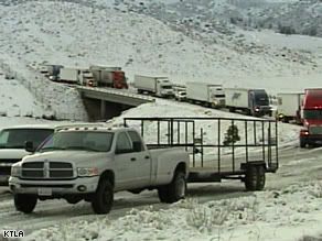
At least 300 motorists stranded in snow north of Los Angeles
LOS ANGELES, California (CNN) -- Jackknifed tractor-trailers Thursday blocked a stretch of Interstate 5 in Southern California, stranding at least 300 people on a snowy mountain pass, the California Highway Patrol said.
Emergency crews worked to open the highway for 300 to 400 vehicles traveling north and south on I-5's Tejon Pass near Gorman, said California Highway Patrol Officer Mark Ehly.
The interstate remained shut for about 40 miles south of Bakersfield to north of Santa Clarita, Ehly said.
"The biggest thing we've got right now is the ice," Ehly said. "It's really cold, and the whole freeway is just literally a skating rink."
A winter storm watch remained in effect for the region until 10 p.m. Friday, according to the National Weather Service, and another 1 to 2 feet of snow was possible above 4,000 feet, including Tejon Pass.
Driver Dave Eskildsen told CNN affiliate KTLA-TV in Los Angeles that he spent a cold night stranded in his car en route from San Diego to Oakland. "I'm just hoping I'm going to get out of here sometime soon," he said. "I left at 2 p.m. yesterday." Watch as the snow causes problems for motorists »
Eskildsen described treacherous traffic conditions during his drive into the mountains. "It was bad. It was horrible. I saw a truck slide and go off the road," he said. "I saw a couple of accidents back there."
Eskildsen said highway patrol officers were checking on motorists and distributing beverages.
Ehly, the highway patrol officer, said Red Cross workers also were passing out food. No motorists were in any danger, he said, during the long wait in six inches of newly fallen snow.
"At the summit -- it's real a climb for the vehicles," Ehly said. "The big trucks start to lose traction and they jackknife and they block two lanes ... and then essentially they've plugged up this pass."
Wendy Gardner, a pub manager in Pine Mountain Club, told The Associated Press that abandoned cars were everywhere.
"We got hit around 2:30 in the morning and it hasn't stopped," Gardner told the AP.
Ehly said he expects the massive traffic jam to end by noon Thursday at the earliest. The area hasn't had a scene such as this in about seven years, he said.
Travel through the area was "highly discouraged," the weather service said, warning of gusty winds and drifting snow that could reduce visibility to near zero.
Heavy rain played havoc in lower-lying areas of Southern California. Santa Barbara reported a record rainfall Wednesday -- 4.16 inches in 24 hours at Santa Barbara Airport, according to the National Weather Service -- smashing the old record of 2.5 inches set in 1943, the service said.
In Long Beach, rain forced 11 residents of an apartment building to find shelter elsewhere after a tarp on a roof under construction failed, according to the Long Beach Press-Telegram.
Forecasters predicted more snow and rain Thursday around Los Angeles.
Flash flooding is possible in and around areas burned in last year's devastating wildfires, the weather service said.
[ Bericht 0% gewijzigd door #ANONIEM op 24-01-2008 21:52:04 ]
POINT MUGU Calif. — Streets flooded, hillsides slipped and commuters cursed Friday as another in a series of powerful winter storms lashed Southern California.
The morning commute was long, wet and, in some cases, treacherous. Traffic accidents doubled compared to the usual rush hour, California Highway Patrol Officer Miguel Luevano estimated.
However, no fatal accidents were reported on Los Angeles-area freeways.
Near downtown, at least two cars were stuck in door handle-deep water on a flooded Hancock Park neighborhood street.
About 6,700 customers were without electricity after power lines toppled, city Department of Water and Power spokeswoman Gale Harris said.
In some hillside areas, minor mudslides were reported but there were no injuries. Canyons scarred by wildfires last fall held despite a fifth day of rain but flash flood watches remained in effect.
Mountain ski resorts enthusiastically welcomed blankets of fresh snow that came in with the storms that began pummeling the region Tuesday.
Some areas have received more rain in the past week than they did the entire year before, National Weather Service meteorologist Jamie Meier said, though experts said the moisture would do little to improve local water supplies.
By Friday morning, Long Beach Airport had received 2.76 inches of rain, compared to 2.1 inches over the previous 12 months, Meier said. Downtown Los Angeles had received 2.54 inches and Gibraltar Dam near Santa Barbara was drenched with 7.56 inches.
A flash flood warning was in effect early Friday in Los Angeles in areas around Griffith Park that were denuded by last year's wildfires.
The Mountain High ski resort received 18 inches of snow, but was forced to temporarily close its slopes Thursday due to high winds.
The National Weather Service issued a winter storm warning for the Santa Barbara County mountains through 10 p.m. Friday. The snow level was expected to drop to between 2,000 and 3,000 feet Thursday night, and down to 1,500 feet during heavier showers or thunderstorms.
At least one waterspout from the Pacific made landfall Thursday night, the National Weather Service said. The tornado tore the roof off of a building at Naval Base Ventura County in Point Mugu, meteorologist Curt Kaplan said.
Vance Vasquez, a base spokesman, said debris was scattered across the runway and "a good portion" of the roof was torn from Hangar 351, which houses aircraft. There were no immediate reports of injuries.
The storm had forced the closure of Interstate 5 late Wednesday on each side of the Grapevine section of Tejon Pass, which soars to an elevation of more than 4,000 feet between the Los Angeles Basin and the San Joaquin Valley. Hundreds of trucks and cars were stuck along a 40-mile stretch of the major north-south artery but most were guided out, the California Highway Patrol said.
A roughly 40-mile stretch of the icy interstate reopened Friday morning after overnight rains helped clear snow on the road, CHP Officer David Porter said.
In Orange County, crews placed safety barriers against several homes in fire-scarred Modjeska Canyon Thursday.
"The rain resulted in a few minor debris flows behind a few houses but as far as I know there was no structural damage," Capt. Mike Blawn of the Orange County Fire Authority said.
Authorities are concerned about another storm forecast to hit the area over the weekend. Forecasters are predicting 4-6 inches to hit south and southwest facing mountain slopes between Saturday night and Sunday morning.
Heavy rain and hail prompted the Santa Anita horse track in Arcadia to cancel races Thursday, the fourth time this month. Its synthetic track has had drainage problems.
The storm was not expected to improve local water supplies. One of the driest rain seasons on record left reservoirs so low last year that several cities called for voluntary water conservation
http://www.foxnews.com/story/0,2933,325467,00.html
The morning commute was long, wet and, in some cases, treacherous. Traffic accidents doubled compared to the usual rush hour, California Highway Patrol Officer Miguel Luevano estimated.
However, no fatal accidents were reported on Los Angeles-area freeways.
Near downtown, at least two cars were stuck in door handle-deep water on a flooded Hancock Park neighborhood street.
About 6,700 customers were without electricity after power lines toppled, city Department of Water and Power spokeswoman Gale Harris said.
In some hillside areas, minor mudslides were reported but there were no injuries. Canyons scarred by wildfires last fall held despite a fifth day of rain but flash flood watches remained in effect.
Mountain ski resorts enthusiastically welcomed blankets of fresh snow that came in with the storms that began pummeling the region Tuesday.
Some areas have received more rain in the past week than they did the entire year before, National Weather Service meteorologist Jamie Meier said, though experts said the moisture would do little to improve local water supplies.
By Friday morning, Long Beach Airport had received 2.76 inches of rain, compared to 2.1 inches over the previous 12 months, Meier said. Downtown Los Angeles had received 2.54 inches and Gibraltar Dam near Santa Barbara was drenched with 7.56 inches.
A flash flood warning was in effect early Friday in Los Angeles in areas around Griffith Park that were denuded by last year's wildfires.
The Mountain High ski resort received 18 inches of snow, but was forced to temporarily close its slopes Thursday due to high winds.
The National Weather Service issued a winter storm warning for the Santa Barbara County mountains through 10 p.m. Friday. The snow level was expected to drop to between 2,000 and 3,000 feet Thursday night, and down to 1,500 feet during heavier showers or thunderstorms.
At least one waterspout from the Pacific made landfall Thursday night, the National Weather Service said. The tornado tore the roof off of a building at Naval Base Ventura County in Point Mugu, meteorologist Curt Kaplan said.
Vance Vasquez, a base spokesman, said debris was scattered across the runway and "a good portion" of the roof was torn from Hangar 351, which houses aircraft. There were no immediate reports of injuries.
The storm had forced the closure of Interstate 5 late Wednesday on each side of the Grapevine section of Tejon Pass, which soars to an elevation of more than 4,000 feet between the Los Angeles Basin and the San Joaquin Valley. Hundreds of trucks and cars were stuck along a 40-mile stretch of the major north-south artery but most were guided out, the California Highway Patrol said.
A roughly 40-mile stretch of the icy interstate reopened Friday morning after overnight rains helped clear snow on the road, CHP Officer David Porter said.
In Orange County, crews placed safety barriers against several homes in fire-scarred Modjeska Canyon Thursday.
"The rain resulted in a few minor debris flows behind a few houses but as far as I know there was no structural damage," Capt. Mike Blawn of the Orange County Fire Authority said.
Authorities are concerned about another storm forecast to hit the area over the weekend. Forecasters are predicting 4-6 inches to hit south and southwest facing mountain slopes between Saturday night and Sunday morning.
Heavy rain and hail prompted the Santa Anita horse track in Arcadia to cancel races Thursday, the fourth time this month. Its synthetic track has had drainage problems.
The storm was not expected to improve local water supplies. One of the driest rain seasons on record left reservoirs so low last year that several cities called for voluntary water conservation


http://www.foxnews.com/story/0,2933,325467,00.html
Dit is weer het andere uiterste....quote:South Florida Adopts One-Day-a-Week Watering
Regional Water Levels Begin Seasonal Decline; Water Shortage Order
Provides “Watering Windows” for Landscape Irrigation
West Palm Beach, FL – For the first time in the agency's history, the South Florida Water Management District (SFWMD) today declared an extreme District-wide water shortage, directly affecting more than five million South Florida residents and thousands of farms and businesses. At its monthly meeting, the District's nine-member Governing Board adopted a groundbreaking water shortage order, instituting a one-day-a-week watering schedule for residential landscape irrigation to conserve regional water supplies. Landscape irrigation accounts for up to half of all household water consumption in Florida and totals more than seven billion gallons per day nationwide.
"Today's order represents the most stringent landscape irrigation measures that this agency has ever had to impose, but we believe it will significantly help to protect and stretch our regional water supplies," said SFWMD Governing Board Chairman Eric Buermann. "We appreciate the public's understanding and compliance with these necessary restrictions that will result in measurable water savings."
The black and white you'll never pass, stick yer blue flag up yer arse!
'They know on the Continent that European football without the English is like a hot dog without the mustard' Sir Bobby Charlton
'They know on the Continent that European football without the English is like a hot dog without the mustard' Sir Bobby Charlton
Live from Michigan:
Voor het sneeuwschuiven:
Na het sneeuwschuiven:
crosspost
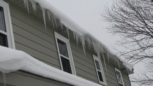


Voor het sneeuwschuiven:

Na het sneeuwschuiven:


crosspost
Patience is not one of my virtues, neither is memory. Or patience for that matter.

Haha, mooie shit! Ik houd lekker de bruine kleur op mijn gezicht, ook al zijn sommige delen vd US leuker als FL; maar niet qua weer hehe. Het koude klimaat is niet echt mijn ding; understatement. (in de zomer is het er wel erg leuk, wanneer is het zomertopic?)quote:
The black and white you'll never pass, stick yer blue flag up yer arse!
'They know on the Continent that European football without the English is like a hot dog without the mustard' Sir Bobby Charlton
'They know on the Continent that European football without the English is like a hot dog without the mustard' Sir Bobby Charlton
Wanneer jij of iemand anders hem opent.
Aan de temps van de afgelopen twee weken te zien is de zomer in Nederland in ieder geval niet ver weg meer
Aan de temps van de afgelopen twee weken te zien is de zomer in Nederland in ieder geval niet ver weg meer
Lokale update:
Hundreds of school closings and lots of minor accidents were caused by the storm that moved through West Michigan Tuesday night and Wednesday morning.
Ik blijf ook nog maar even thuis.
Hundreds of school closings and lots of minor accidents were caused by the storm that moved through West Michigan Tuesday night and Wednesday morning.
Ik blijf ook nog maar even thuis.
Patience is not one of my virtues, neither is memory. Or patience for that matter.
Midwest braces for 'vicious slap from Mother Nature'
CHICAGO, Illinois (AP) -- Severe thunderstorms, tornadoes and fierce winds sliced through the Midwest, leaving behind bitterly cold air and blizzards in the northern Plains that sent temperatures in some areas plummeting by 50 degrees in a few hours.
Forecasters warned more bad weather was on the way Wednesday.
"This is going to be a hard, vicious slap in the face from Mother Nature," Gino Izzi, a meteorologist with the National Weather Service in Romeoville, Illinois, said Tuesday night. "The temperature drop we saw was really spectacular in a bad way."
High winds associated with thunderstorms may have killed two people in Indiana, authorities said Tuesday. Snow forced the closure of schools and highways in many areas, and avalanche warnings were issued for some Western regions.
"I wouldn't call it a common occurrence to see winds this strong with this kind of snow," Izzi said. "This isn't something we see every year."
The cold air and wind gusts as high as 70 mph slammed into the Midwest, where fog created problems for air travel Tuesday in Chicago. About 350 flights were canceled Tuesday at O'Hare International Airport, said Chicago Department of Aviation spokesman Karen Pride.
The system also dragged frigid air across the northern Plains. The Weather Service reported a midday temperature of 24 degrees below zero at Glasgow, Montana. North Dakota registered wind chill factors of 54 below zero at Garrison, while Williston hit a low of 24 below.
Most of Minnesota was under wind chill warnings until noon Wednesday due to indexes that fell into the minus 30 degree level. It was as low as 50 degrees below freezing in Hibbing.
Though only light snow fell in western, central and eastern Iowa on Tuesday, winds snapping as fast as 60 mph caused visibility problems, and temperatures dropped into single digits.
In north central and eastern Iowa, forecasters expected strong winds and blowing snow to continue overnight, and for temperatures to possibly dip to 10 below zero.
"It's a little worse than your average snowstorm," said Rod Donovan, a meteorologist with the National Weather Service in Des Moines, Iowa. "The biggest impact is that the driving conditions can change quickly with this type of storm. Once it begins, travel is quite hazardous."
Some 1,500 workers went home early from the Mayo Clinic in Rochester, Minnesota, while critical medical staff were put up in hotels so they could stay close to serve patients. The blustery winds also put flight operations on ice at the Rochester airport.
Firefighters in southwestern Indiana pulled two bodies from a mobile home near Evansville that had been turned on its side by winds in a thunderstorm, WEHT-TV reported.
Residents near Danville, west of Indianapolis, reported funnel clouds, and damage was reported to a home and the Morgan County Courthouse in Martinsville.
The National Weather Service reported an unconfirmed tornado touchdown near Okawville, Illinois. A corner of the roof peeled off a high school in Nashville, Illinonis, but no injuries were reported.
Temperatures in Illinois dropped from Tuesday's highs in the 40s to about zero overnight. In anticipation, some central Illinois schools canceled Wednesday classes.
In Cape Girardeau County, Missouri, winds as strong as 70 mph and dime-size hail were reported Tuesday. Two unconfirmed funnel clouds were reported, said Dick Knaup, the county's emergency management director.
The week began with heavy snow pummeling mountain areas from Washington state to northern Arizona as two storms converged, one from hard-hit California and another from the Gulf of Alaska, meteorologists said. Watch residents struggle in Spokane, Washington »
The storms were followed Tuesday by a third that threatened to leave up to 20 inches of snow in Idaho's mountains, said Jay Breidenbach of the Weather Service office in Boise, Idaho.
A fourth storm was on the way to the interior West: "By Thursday, the next storm will be right on our doorstep. This is quite a storm system," Breidenbach said.
The Navajo reservation, which sprawls across parts of Arizona, Utah and New Mexico, was under an emergency declaration because of the possibility that melting snow could create flooding.
In the snow farther west, avalanche danger forced officials to close Interstate 90 at Snoqualmie Pass, Washington state's main east-west artery across the Cascade Mountains. The pass was to remain closed until Wednesday morning, Meagan McFadden of the state Department of Transportation said.
More than 200 trucks were backed up at North Bend, waiting to move freight across the pass. On a typical weekday, as many as 7,000 trucks travel I-90 over Snoqualmie Pass, she added.
Snow also closed highways in Minnesota, Colorado and Wyoming.
Two of three snowmobilers lost in the mountains west of Denver were found late Tuesday, said Summit County sheriff's spokeswoman Paulette Horr. The third was still missing.
In Oregon, two snowmobilers were rescued Monday after spending two nights in the Wallowa Mountains, where they were trapped by storms. Authorities said the two were dressed warmly and equipped with survival gear, matches and an avalanche beacon.
CHICAGO, Illinois (AP) -- Severe thunderstorms, tornadoes and fierce winds sliced through the Midwest, leaving behind bitterly cold air and blizzards in the northern Plains that sent temperatures in some areas plummeting by 50 degrees in a few hours.
Forecasters warned more bad weather was on the way Wednesday.
"This is going to be a hard, vicious slap in the face from Mother Nature," Gino Izzi, a meteorologist with the National Weather Service in Romeoville, Illinois, said Tuesday night. "The temperature drop we saw was really spectacular in a bad way."
High winds associated with thunderstorms may have killed two people in Indiana, authorities said Tuesday. Snow forced the closure of schools and highways in many areas, and avalanche warnings were issued for some Western regions.
"I wouldn't call it a common occurrence to see winds this strong with this kind of snow," Izzi said. "This isn't something we see every year."
The cold air and wind gusts as high as 70 mph slammed into the Midwest, where fog created problems for air travel Tuesday in Chicago. About 350 flights were canceled Tuesday at O'Hare International Airport, said Chicago Department of Aviation spokesman Karen Pride.
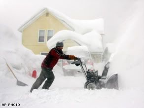
The system also dragged frigid air across the northern Plains. The Weather Service reported a midday temperature of 24 degrees below zero at Glasgow, Montana. North Dakota registered wind chill factors of 54 below zero at Garrison, while Williston hit a low of 24 below.
Most of Minnesota was under wind chill warnings until noon Wednesday due to indexes that fell into the minus 30 degree level. It was as low as 50 degrees below freezing in Hibbing.
Though only light snow fell in western, central and eastern Iowa on Tuesday, winds snapping as fast as 60 mph caused visibility problems, and temperatures dropped into single digits.
In north central and eastern Iowa, forecasters expected strong winds and blowing snow to continue overnight, and for temperatures to possibly dip to 10 below zero.
"It's a little worse than your average snowstorm," said Rod Donovan, a meteorologist with the National Weather Service in Des Moines, Iowa. "The biggest impact is that the driving conditions can change quickly with this type of storm. Once it begins, travel is quite hazardous."
Some 1,500 workers went home early from the Mayo Clinic in Rochester, Minnesota, while critical medical staff were put up in hotels so they could stay close to serve patients. The blustery winds also put flight operations on ice at the Rochester airport.
Firefighters in southwestern Indiana pulled two bodies from a mobile home near Evansville that had been turned on its side by winds in a thunderstorm, WEHT-TV reported.
Residents near Danville, west of Indianapolis, reported funnel clouds, and damage was reported to a home and the Morgan County Courthouse in Martinsville.
The National Weather Service reported an unconfirmed tornado touchdown near Okawville, Illinois. A corner of the roof peeled off a high school in Nashville, Illinonis, but no injuries were reported.
Temperatures in Illinois dropped from Tuesday's highs in the 40s to about zero overnight. In anticipation, some central Illinois schools canceled Wednesday classes.
In Cape Girardeau County, Missouri, winds as strong as 70 mph and dime-size hail were reported Tuesday. Two unconfirmed funnel clouds were reported, said Dick Knaup, the county's emergency management director.
The week began with heavy snow pummeling mountain areas from Washington state to northern Arizona as two storms converged, one from hard-hit California and another from the Gulf of Alaska, meteorologists said. Watch residents struggle in Spokane, Washington »
The storms were followed Tuesday by a third that threatened to leave up to 20 inches of snow in Idaho's mountains, said Jay Breidenbach of the Weather Service office in Boise, Idaho.
A fourth storm was on the way to the interior West: "By Thursday, the next storm will be right on our doorstep. This is quite a storm system," Breidenbach said.
The Navajo reservation, which sprawls across parts of Arizona, Utah and New Mexico, was under an emergency declaration because of the possibility that melting snow could create flooding.
In the snow farther west, avalanche danger forced officials to close Interstate 90 at Snoqualmie Pass, Washington state's main east-west artery across the Cascade Mountains. The pass was to remain closed until Wednesday morning, Meagan McFadden of the state Department of Transportation said.
More than 200 trucks were backed up at North Bend, waiting to move freight across the pass. On a typical weekday, as many as 7,000 trucks travel I-90 over Snoqualmie Pass, she added.
Snow also closed highways in Minnesota, Colorado and Wyoming.
Two of three snowmobilers lost in the mountains west of Denver were found late Tuesday, said Summit County sheriff's spokeswoman Paulette Horr. The third was still missing.
In Oregon, two snowmobilers were rescued Monday after spending two nights in the Wallowa Mountains, where they were trapped by storms. Authorities said the two were dressed warmly and equipped with survival gear, matches and an avalanche beacon.
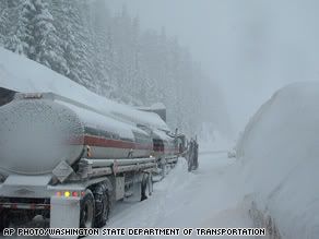
wij hadden eergister temperatuur verschil van 20 graden celsius, ik keek sochtends het was 18 graden! 6 uur later -2
nu sneeuwt het een beetje, is wel leuk, lekker met een front wheel drive auto donuts draaien enzo
nu sneeuwt het een beetje, is wel leuk, lekker met een front wheel drive auto donuts draaien enzo
Mijn usericon is mede mogelijk gemaakt door wonderer.
Live from Sparta MO
JOE-ES-EE!!
Live from Sparta MO
JOE-ES-EE!!
40 care pileup on Interstate 40 in heavy storm
LUBBOCK, Texas — Yet another storm swept across the central United States, burying areas still recovering from an earlier wave of severe weather, tying up air travel and killing at least four people.
A 40-car pileup on Interstate 40 in northern Texas that killed at least one person was caused by blowing snow that limited visibility and left icy patches Thursday, said Wayne Beighle, a Texas Department of Public Safety trooper.
The storm has been blamed for at least three other deaths: two in Texas and one in Oklahoma.
Elswhere in Texas, firefighters in several counties battled wind-driven wildfires, including a 2,000-acre (800-hectare) blaze northwest of Fort Worth that was expected to be contained later Thursday.
The storm pounded areas of the Midwest still rebounding from storms earlier in the week that spawned a mix of snow, brutal cold, tornadoes and hail.
More than 600 flights in and out of Chicago's O'Hare International Airport, one of the nation's busiest, were canceled, and others were delayed an average of two hours. Flights were also canceled at some other area airports, including Indianapolis, where 6 inches to 8 inches (15 to 20 centimeters) of snow was to predicted to fall.
In the West, searchers found the body of a Colorado man who died on snowmobiling trip in the mountains west of Denver.
John McKibben and two companions got lost during a one-day outing Sunday. The other two men were rescued Tuesday but told search crews that McKibben died Monday night.
http://www.foxnews.com/story/0,2933,327410,00.html

Zo ziet een lokale waarschuwing er dan uit:
HEAVY SNOW WARNING REMAINS IN EFFECT UNTIL 7 PM EST THIS
EVENING...
EXPECT 6 TO 10 INCHES FROM HOLLAND THROUGH GRAND RAPIDS AND MOUNT
PLEASANT AND 8 TO 14 INCHES FROM KALAMAZOO TO LANSING AND JACKSON
BY THIS AFTERNOON.
SNOWFALL RATES MAY EXCEED AN INCH PER HOUR THIS MORNING. THIS WILL
RESULT IN VISIBILITIES LESS THAN A MILE WHICH WILL MAKE TRAVELING
HAZARDOUS. THE PERIOD OF HEAVIEST SNOWFALL IS EXPECTED BETWEEN 6
AM AND NOON. SNOW WILL BEGIN TO TAPER OFF BY LATE AFTERNOON.
A HEAVY SNOW WARNING MEANS SIGNIFICANT AMOUNTS OF SNOW WILL MAKE
TRAVEL DANGEROUS. ONLY TRAVEL IN AN EMERGENCY. IF YOU MUST
TRAVEL...KEEP AN EXTRA FLASHLIGHT...FOOD...AND WATER IN YOUR
VEHICLE IN CASE OF AN EMERGENCY.
Er zijn in West Michigan al meerdere mensen omgekomen door de kou, veelal mensen met motorpech en een slechte voorbereiding (geen warme kleren en eten in de auto etc.)
Weather Cams in Michigan.
Patience is not one of my virtues, neither is memory. Or patience for that matter.
10 inches is ongeveer 25 cm. Dat zou een lekker weeralaram opleveren.quote:Op vrijdag 1 februari 2008 13:40 schreef Frutsel het volgende:
Heavy snow
dat wil ik hier ook wel weer eens
Hier is de live radar.
Patience is not one of my virtues, neither is memory. Or patience for that matter.
Veel sneeuw in Oregon
In de stad Detroit in Oregon op 140 kilometer afstand van Portland is de afgelopen weken veel sneeuw gevallen. Het totaal is opgelopen tot 4 meter sneeuw in 6 weken tijd.
In de omgeving is de noodtoestand uitgeroepen. Sinds de kerst valt er constant sneeuw. In deze regio is men wel sneeuw gewend, maar dit jaar valt er bijzonder veel. Bovendien ontstaan er steeds vaker lawines, die belangrijke wegen blokkeren.
Uit de omliggende plaatsen zijn extra sneeuwschuivers aangevoerd, om de straten enigszins berijdbaar te houden. Regelmatig valt ook de water en elektriciteitsvoorziening uit. Voor dit weekend wordt nog eens 60 centimeter sneeuw verwacht.
www.vwkweb.nl
4 meter in 6 weken.
* appelsientje is jaloers...quote:Op vrijdag 1 februari 2008 13:53 schreef popolon het volgende:
[..]
10 inches is ongeveer 25 cm. Dat zou een lekker weeralaram opleveren.
Hier is de live radar.
To deny our impulses would deny the very thing that make us human.

't Is koud in de midwest. Aan de grens met Canada -30 met gevoelstemperaturen van rond de -50.
Patience is not one of my virtues, neither is memory. Or patience for that matter.
Icebox of the Nation, -40 C
MINNEAPOLIS — It lived up to its name: The temperature in International Falls fell to 40 below zero Monday, just a few days after the northern Minnesota town won a federal trademark making it officially the "Icebox of the Nation."
It was so cold that resident Nick McDougall couldn't even get his car trunk lid to close after he got out his charger to kick-start his dead battery. By late morning, the temperature had risen all the way to 18 — below zero.
"This is about as cold as it gets, this is bad. There's no wind — it's just cold," said McDougall, 48, a worker at The Fisherman, a convenience store and gas station in the town on the Canadian border. "People just don't go out, unless you have to go to work."
Like many Minnesota residents, he uses an electric engine block heater to keep his car from freezing.
"You plug in your car, for sure, and you put the car in the garage if you can," McDougall said. His garage is full of other things, so he had to park outside — a "big mistake."
The previous record low for Feb. 11 in International Falls was 37 below, set in 1967, said meteorologist Mike Stewart at the weather service in Duluth. The cold was expected, he said: "When the winds finally died off and the skies cleared off, it just dropped."
The temperature also fell to 40 below in Embarrass, 80 miles southeast of International Falls. That's just one degree above the all-time record in Minneapolis, 250 miles to the south, that was set in January 1888, the weather service said.
Chilly air also spread into the Northeast on Monday and many schools in New York state between Buffalo and Syracuse closed or opened late. Single-digit temperatures plus high wind drove the wind chill factor to nearly 20 below across much of upstate New York.
Philadelphia had a "Code Blue" alert in effect, sending outreach crews to coax homeless people into shelters. Monday's low of 10 above zero.
Farther south, freezing rain hit southwest Missouri early Monday, making roads hazardous and losing schools. A coating of ice up to an inch thick was expected across much of southern and central Missouri, the weather service said.
"It's treacherous. If you can stay home this morning, do it," Missouri Highway Patrol Sgt. Dan Bracker said in Springfield.
Thousands of West Virginia homes and businesses had no electricity Monday after the state was hit by weekend wind gusts of up to 55 mph. At least nine counties closed schools because of power outages and the cold — the mountain city of Elkins had a low of 6 above.
Classes also were canceled Monday for a number of schools in Michigan, which remained in a deep freeze after a weekend of single-digit temperatures and gusty wind. One death was blamed on the weather.
http://www.foxnews.com/story/0,2933,330332,00.html
hier ligt nu 5 cm MINSTENS ijzel overal, sommige plaatsen meerquote:Op maandag 11 februari 2008 20:36 schreef Frutsel het volgende:
Icebox of the Nation, -40 C
Farther south, freezing rain hit southwest Missouri early Monday, making roads hazardous and losing schools. A coating of ice up to an inch thick was expected across much of southern and central Missouri, the weather service said.
"It's treacherous. If you can stay home this morning, do it," Missouri Highway Patrol Sgt. Dan Bracker said in Springfield.
http://www.foxnews.com/story/0,2933,330332,00.html
[ Bericht 59% gewijzigd door compier op 13-02-2008 05:14:05 ]
Mijn usericon is mede mogelijk gemaakt door wonderer.
Live from Sparta MO
JOE-ES-EE!!
Live from Sparta MO
JOE-ES-EE!!
Hundreds stranded in San Diego by surprise snowblizzard
SAN DIEGO — A surprise storm lashed San Diego County with rain and snow, stranding as many as 500 motorists on a mountain freeway and pouring mud down onto another roadway but causing no major damage or injuries.
The weather was expected to clear Friday.
A 27-mile stretch of Interstate 8, which runs through the mountains in the eastern county and is a main artery from California into Arizona, was reopened before dawn Friday following a 12-hour shutdown.
The California Highway Patrol began escorting cars through, although big-rig trucks still were not allowed. The freeway was closed shortly after 4 p.m. Thursday when blowing snow and ice made the roadway impassable.
"It was just a big dump of snow, real fast," accompanied by high winds, California Highway Patrol Officer Jim Bettencourt said.
Cars spun out and hundreds of motorists were stopped in their tracks.
"I've been here for a while and trying to get around, but there's no going around, so you just have to be patient," stranded motorist Patty Kresin told KNSD-TV in San Diego.
Search-and-rescue teams went car to car. At least 30 people were taken to temporary shelters at a fire station and a casino nearby, according to the California Department of Forestry and Fire Protection.
By early Friday, authorities were pretty sure they had found all the stranded motorists, but teams were still checking for cars that might have gone over the side of the road, Bettencourt said.
The abandoned cars hampered snow plows.
"Now we have a virtual parking lot of empty vehicles," Bettencourt said. "You've got big rigs that are jackknifed. So it's going to be a pretty daunting task."
The unexpectedly severe weather snarled other roadways. Authorities reported 179 crashes on county roads between midnight and 9 p.m. Thursday, compared to the usual figure of 50 to 75 crashes in a typical day.
Authorities also shut down an 8-mile stretch of road between Poway and Ramona because of mudslides. About 2 feet of mud and rocks slid onto the highway after heavy rain fell in an area burned by last fall's wildfires.
The stormy weather was caused by a low-pressure system that originated in the Gulf of Alaska and unexpectedly moved into Southern California.
Rain, hail and snow also fell in the desert near Palm Springs where temperatures had soared to 85 degrees just days ago.
http://www.foxnews.com/story/0,2933,330790,00.html
Verkeerschaos in New York door onverwachte sneeuwstorm
Sneeuwstormen en ijzel hebben vrijdag in New York voor verkeerschaos gezorgd.
Wegens de onverwachte winterprik moesten op de drie luchthavens van de stad tegen de avond bijna 1.100 vluchten geannuleerd worden. Er waren wachttijden tot negen uur.
Op de spekgladde wegen viel het verkeer op vele plaatsen stil. Ruim 2.000 arbeiders waren zonder rusten aan de slag om de in totaal ongeveer 10.000 kilometer aan wegen in de miljoenenstad vrij te maken. De stad moest bijkomende hulp inhuren.
Vrijdagvoormiddag ontving de ombudsdienst meer dan 50.000 oproepen van radeloze New Yorkers, die niet wisten hoe ze op hun werk konden geraken. Tegen de avond verbeterde de situatie zich enigszins.
In de nacht van donderdag op vrijdag kwam er na enkele dagen helder weer plotseling een sneeuwstorm opsteken. In Central Park in hartje Manhattan viel volgens de weerkundige dienst 15 centimeter sneeuw, in de wijk Staten Island viel met 20 centimeter een record. Voor New York was het de zwaarste sneeuwval in twee jaar.
bron

"Pain is my friend. I can trust pain. I can trust pain to make my life utterly miserable."
"My brain is too smart for me."
"We don't need no education." "Yes you do, you just used a double negative."
"My brain is too smart for me."
"We don't need no education." "Yes you do, you just used a double negative."
Hey Grand Rapids. 
Patience is not one of my virtues, neither is memory. Or patience for that matter.
I second that.quote:
"Pain is my friend. I can trust pain. I can trust pain to make my life utterly miserable."
"My brain is too smart for me."
"We don't need no education." "Yes you do, you just used a double negative."
"My brain is too smart for me."
"We don't need no education." "Yes you do, you just used a double negative."
Vroege winterprik in het westen van de VS
De streek rond Montana Wyoming werd geteisterd door vroege sneeuwval, er viel ruim 7 cm sneeuw. Hierbij werd het record van oktober 1969 verbroken.
De sneeuwbuien gingen gepaard met felle wind, dit veroorzaakte heel wat verkeersellende, wegen werden versperd door omgewaaide bomen.
Meer dan 2500 gezinnen hadden geen stroomvoorziening. Ook het vliegverkeer ondervond hinder door de weersomstandigheden. Vluchten liepen vertragingen op of werden geannuleerd.
vwk
De streek rond Montana Wyoming werd geteisterd door vroege sneeuwval, er viel ruim 7 cm sneeuw. Hierbij werd het record van oktober 1969 verbroken.
De sneeuwbuien gingen gepaard met felle wind, dit veroorzaakte heel wat verkeersellende, wegen werden versperd door omgewaaide bomen.
Meer dan 2500 gezinnen hadden geen stroomvoorziening. Ook het vliegverkeer ondervond hinder door de weersomstandigheden. Vluchten liepen vertragingen op of werden geannuleerd.
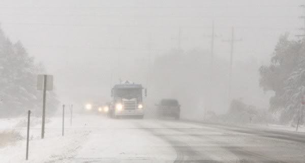
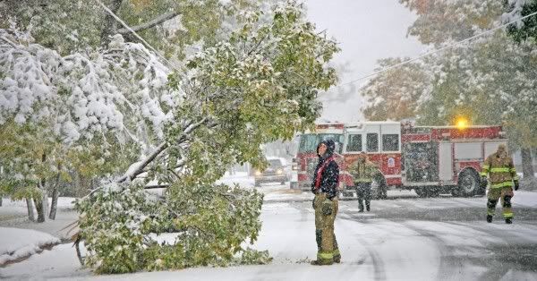
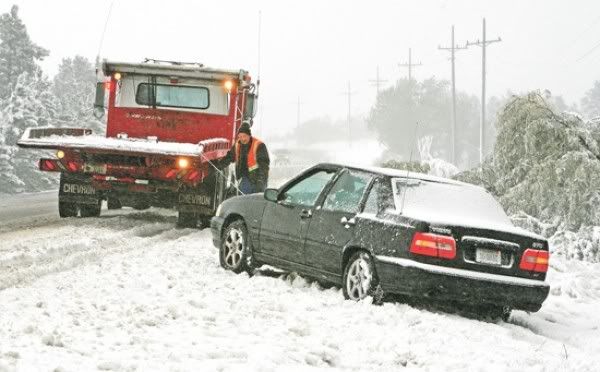
vwk
Kan iemand Al Gore even bellen dat z'n global warming niet doorgaat?
Haha, U schakelt nog. Test een DAF !

quote:The first big winter storm arrived in Illinois and neighboring states in early December 2008. Heavy snow caused fatal car accidents and delayed air travel in Chicago and regional airports for hours. This image of the freshly fallen snow was captured by the Moderate Resolution Imaging Spectroradiometer (MODIS) on NASA’s Aqua satellite on December 2. Clouds lingered over Lake Michigan, but clear skies over northern Illinois showed the blanket of snow. The whitened landscape highlights the paths of rivers and streams as well as urban areas, which appear cement gray. According to AP news reports, “[t]the heaviest snow fell Sunday and early Monday across a stretch of central Illinois roughly along Interstate 74 from west of Peoria to east of the Bloomington-Normal area.”
Oi oi...
TVP voor mijn vakantie in januari naar Carolina/Virginia/Pennsylvania en NY
TVP voor mijn vakantie in januari naar Carolina/Virginia/Pennsylvania en NY
The Killers Heracles Almelo Real Madrid
29.10 Novastar HMH
29.10 Novastar HMH
Pfff.quote:Op woensdag 10 december 2008 12:07 schreef Damzkieee het volgende:
Oi oi...
TVP voor mijn vakantie in januari naar Carolina/Virginia/Pennsylvania en NY
In West Michigan viel van het weekend bijna 30cm sneeuw.
Patience is not one of my virtues, neither is memory. Or patience for that matter.
Weer een heleboel amerikanen zonder stroom.
New England Storm Cuts Power to More Than a Million
New England Storm Cuts Power to More Than a Million
quote:Dec. 12 (Bloomberg) -- An ice storm that moved through the eastern U.S. overnight knocked down trees and wires from southern New York to Maine, cutting power to about 1.25 million customers and closing roads, schools and train lines.
The National Weather Service issued winter storm warnings from southwestern Pennsylvania to northern Maine as the low- pressure system dumped more than 7 inches (18 centimeters) of snow and coated tree limbs, streets and wires with as much as an inch of ice.
The governors of Massachusetts and New Hampshire declared states of emergency after about 700,000 homes and businesses lost power. In Maine, Governor John Baldacci ordered state government closed for the day.
At the Miss Worcester Diner in Worcester, Massachusetts, customers were coming in with stories of downed limbs and power failures, with some saying they’d been told they may not have electricity until the end of the weekend. Owner Kim Kniskern, 41, said she had to drive under a fallen tree to get to work.
“My husband was behind me in his truck and he couldn’t fit under the tree, so he had to go another way,” she said.
Entergy Corp. said it slowed its Vermont Yankee nuclear reactor to 82 percent of capacity at the request of the power grid operator after “massive power outages” threatened the grid’s stability. The plant is located 103 miles (166 kilometers) northwest of Boston.
Lines Down
“There’s massive power outages, ice on lines, trees on lines,” Entergy spokesman Larry Smith said. “We’re just riding out the ice storm.”
About 500,000 National Grid Plc customers were without electricity in New England and New York, including about 290,000 in central and eastern Massachusetts, according to the company’s Web site.
“It’s clear that we will be at this in New England and New York for at least several days,” National Grid spokesman Steve Brady said in a telephone interview. “We’ve got a fair amount of physical damage to the network, trees and tree limbs and that sort of thing. We’re going to have an army out there.”
Amtrak canceled service through the early afternoon on its Empire Line between New York City and the state capital of Albany because of downed trees and wires. It also halted trains on its Downeaster line between Boston and Portland, Maine, and its Maple Leaf line between New York City and Toronto, spokeswoman Karina Romero said in a telephone interview.
Storm Moving Out
“It’s turned from ice to rain so we’re hoping that will help things,” Romero said. “The good news is the storm seems to be moving.”
The American Red Cross is opening shelters throughout the Northeast to help people affected by the storm, including 11 in New Hampshire and six in upstate New York. The Granite chapter in Concord, New Hampshire, opened 12 shelters statewide after being “inundated” with calls for aid, spokeswoman Becky Field said.
“We definitely have had a lot of calls,” Field said. “Although the weather here in Concord is letting up quite a bit, a lot of people don’t have power.”
quote:IJsstorm treft deel Verenigde Staten
BOSTON - Een krachtige ijsstorm heeft vrijdag in het noordoosten van de Verenigde Staten grote problemen veroorzaakt. In zeven staten, waaronder New York, kwamen ruim een miljoen huishoudens en ondernemingen zonder stroom te zitten.
In meerdere staten werd de noodtoestand afgekondigd.
In Maine zagen de autoriteiten zich gedwongen overheidsgebouwen te sluiten. De gouverneur van New Hampshire sprak over een uiterst ernstige situatie.
De regering van Massachusetts zette vijfhonderd leden van de Nationale Garde in om wegen van ijs te bevrijden en bewoners te helpen.
quote:In het noordoosten van Amerika zitten ruim een miljoen Amerikanen zonder stroom nadat een zware ijsstorm over het land trok. Het ijs heeft hoogspanningskabels en pylonen doen knappen. Het kan nog dagen duren voordat alle Amerikanen terug stroom hebben.
"De regen en het ijs veroorzaken problemen. Het ijs weegt op de boomtakken, waardoor die afbreken en op de elektriciteitskabels vallen", vertelt de woordvoerder van de regionale elektriciteitsmaatschappij Northeast Utilities.
De ijsstorm is de ergste in jaren. Massachussetts, New Hampshire en delen van Maine en New York hebben de noodtoestand afgekondigd. Verwacht wordt dat de stormen nog dagen zullen blijven duren, en dat de temperatuur nog meer zal dalen.
De storm heeft op dit moment aan 4 mensen het leven gekost. (Gazet van Antwerpen)
quote:IceStorm strikes Northeast US
CONCORD, N.H. — An ice storm to compare with some of the Northeast's worst made a mess of the region Friday, leaving 1.25 million homes and businesses in seven states without power as it forced schools to close and toppled ice-laden trees and power lines onto slippery roads.
More than half of New Hampshire's homes and businesses lost power, and it was expected to take several days to completely restore electricity there and in other states. The storm wreaked havoc from Maine to Pennsylvania, leaving a sparkling, ice-covered landscape that was too destructive for many to find beautiful.
"This is pathetic," said Bob Cott of Portland, Maine, who lost power. "I'm already sick of winter and we have nine days to go before it officially begins."
At least one death was related to the storm: New Hampshire officials said a 49-year-old Danville man who lived in a camper died of carbon monoxide poisoning after turning on his generator when his power went out Thursday night.
For New Hampshire, the power outages dwarfed those during the infamous Ice Storm of '98, when some residents spent more than a week in the dark.
In Hampstead, N.H., Mark Cegelis, 36, said things were hectic at his neighborhood gas station, which was jammed with people trying to get gas for home generators.
"It's kind of lawless out there right now," he said. "There's a lot of people very frustrated stacking up at the gas stations. It's pretty ugly."
He bought 21 gallons for himself and tried to deliver some to friends in Derry but couldn't get there because downed trees blocked roads. So the two friends came to him instead, and were expected to hunker down with Cegelis' family, his parents and another friend until power was restored.
"I'm sure they'd do the same thing for us," he said. "It's treacherous out there."
Nearly two dozen shelters were set up across the southern part of the state, and authorities were working to get generators to several nursing homes. About 35 people, mostly elderly, had settled in at a shelter at Portsmouth High School by early afternoon.
"All the motels have no electricity, and that's why I'm here," said Duke Straychan of Hampton, who can't do without power because he uses an oxygen tank at night. People at the shelter dined on American chop suey and shepherd's pie and watched "The Polar Express" in the cafeteria.
Gov. John Lynch urged residents to "please go out of your way" to check on their neighbors, especially those who are elderly and live alone.
Both Lynch and Massachusetts Gov. Deval Patrick declared states of emergency Friday morning and called up members of the National Guard. Five hundred Massachusetts Guard members were cleaning up debris and clearing access to downed power lines. Lynch put 150 on alert and deployed 20.


quote:VS getroffen door bar winterweer
WASHINGTON - Grote delen van de Verenigde Staten zijn getroffen door bar winterweer met hevige sneeuwval en sneeuwstormen. Vooral het noorden is zwaar getroffen, meldden Amerikaanse media zondag. Door het noodweer liep het vliegverkeer op een aantal belangrijke luchthavens grote vertragingen op. Ook werden veel wegen onbegaanbaar en kwamen tienduizenden zonder stroom te zitten.
Er viel de afgelopen dagen zeker een dode. In Massachusetts in het noordoosten kwam een man om het leven toen hij werd geraakt door een grote boomtak die door het gewicht van sneeuw was afgebroken.
Beperkt zicht
In het noorden van Iowa werden automobilisten opgeroepen niet de weg op te gaan vanwege het zeer beperkte zicht door zware sneeuwval. In Iowa en Illinois in het Midwesten is gewaarschuwd voor hevige sneeuwstormen.
Ook in de staten Michigan en Maine worden dergelijke waarschuwingen afgegeven. In Maine valt zondag en maandag waarschijnlijk 25 tot 45 centimeter sneeuw. De temperaturen zijn er tot ver onder het vriespunt gezakt.
Meteorologen
Ook de staten Washington en Oregon in het noordwesten zijn zwaar getroffen door sneeuwstormen. Volgens meteorologen is het zeker vijftien jaar geleden dat dit deel van de Verenigde Staten met zulk bar winterweer te maken had.

Hallo.quote:Ook in de staten Michigan en Maine worden dergelijke waarschuwingen afgegeven.
Patience is not one of my virtues, neither is memory. Or patience for that matter.
Het is belachelijk weer Bijna 50 cm in twee dagen hier.
"Pain is my friend. I can trust pain. I can trust pain to make my life utterly miserable."
"My brain is too smart for me."
"We don't need no education." "Yes you do, you just used a double negative."
"My brain is too smart for me."
"We don't need no education." "Yes you do, you just used a double negative."
Ah, daar komen we toch nietquote:
Hoe is het weer around NY/WAS/PIT ?
The Killers Heracles Almelo Real Madrid
29.10 Novastar HMH
29.10 Novastar HMH
Rest van het berichtquote:CHICAGO — Rain and rapidly rising temperatures accompanied by thick fog threatened to cause flooding Saturday in the Midwest after days of Arctic cold, heavy snow and ice.
Thick ice on roads that contributed to dozens of deaths had thawed and mountains of snow turned into pools and streams of water.
"It's a Catch 22," said Marisa Kollias, spokeswoman for the Illinois Department of Transportation. "We're getting rid of one problem, the ice, but we're getting another problem with the flooding
The National Weather Service posted flood watches and warnings Saturday for parts of Illinois, Iowa, Wisconsin, Indiana, Michigan and Missouri. As much as 2 inches of rain fell in two hours during the night in west-central Illinois, the National Weather Service reported Saturday.
And as warm air collided with cold, the weather service posted tornado watches for parts of Texas, Oklahoma, Arkansas, Missouri, Illinois and Kansas.
After subzero temperatures in places earlier in the week, Saturday morning readings were in the 40s as far north as Cheboygan, Mich., at the top of the state's Lower Peninsula, the weather service said. However, up to 7 inches of snow is possible in the state Sunday, the agency said.

