WKN Weer, Klimaat en Natuurrampen
Lees alles over het onstuimige weer op onze planeet, volg orkanen en tornado's, zie hoe vulkanen uitbarsten en hoe Moeder Aarde beeft bij een aardbeving. Alles over de verwoestende kracht van onze planeet en tal van andere natuurverschijnselen.


Cyclone Helen hits Northern Australia
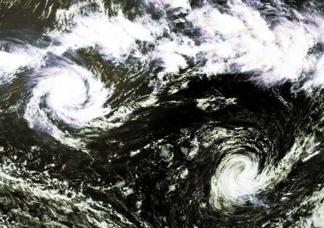
A variety of weather phenomena combined to deliver heavy rains to parts of Australia in the first week of January 2008, bringing a mixture of drought relief as well as some severe flooding. A substantial amount of rain along the northern coastline was due to Cyclone Helen, which formed in the southeastern Timor Sea area (image left) off the western coast of the Northern Territory.
This image shows rainfall totals across northern Australia between January 1-8, 2008, based on data from near-real-time, Multi- satellite Precipitation Analysis (MPA) at NASA Goddard Space Flight Center. The MPA is based in part on data from the Tropical Rainfall Measuring Mission (TRMM) satellite. The highest rainfall totals for the period (shown in dark red) are over 500 millimeters (~20 inches) in the eastern Gulf of Carpentaria (right of center). Over land, a broad area of 100 millimeters (~4 inches) extends from the northern coastline of Western Australia across the Northern Territory and into the York Peninsula in the east (green areas).
Even before Cyclone Helen, the northern coastline of Australia was already experiencing wet weather due to the interaction of monsoon rains with the Madden-Julian Oscillation (MJO). The MJO is a periodic atmospheric disturbance during which a large area of thunderstorms bubbles up in the Indian Ocean and slowly drifts eastward into the Pacific over the course of 30–60 days. The most recent MJO event was moving into the western Pacific Ocean in early January.
bron:

Tropical Storm FUNA
quote:Tropical storm Funa is forecast to strike Vanuatu as a tropical cyclone at about 06:00 GMT on 17 January. Data supplied by the US Navy and Air Force Joint Typhoon Warning Center suggest that the point of landfall will be near 14.8 S, 168.2 E. Funa is expected to bring 1-minute maximum sustained winds to the region of around 120 km/h (74 mph). Wind gusts in the area may be considerably higher.
According to the Saffir-Simpson damage scale the potential property damage and flooding from a storm of Funa's strength (category 1) at landfall includes:
Storm surge generally 1.2-1.5 metres (4-5 feet) above normal.
No real damage to building structures.
Damage primarily to unanchored mobile homes, shrubbery, and trees.
Some damage to poorly constructed signs.
Some coastal road flooding and minor pier damage.
There is also the potential for flooding further inland due to heavy rain.

Tropical storm Fame is forecast to strike Madagascar as a tropical cyclone at about 18:00 GMT on 27 January. Data supplied by the US Navy and Air Force Joint Typhoon Warning Center suggest that the point of landfall will be near 15.9 S, 44.1 E. Fame is expected to bring 1-minute maximum sustained winds to the region of around 120 km/h (74 mph). Wind gusts in the area may be considerably higher.
Twee doden door tropische storm Fiji
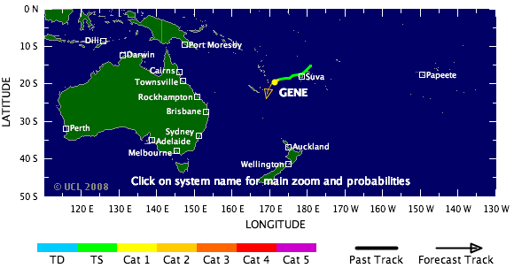
De tropische storm Gene is dinsdag over Fiji getrokken. Daarbij zijn twee mensen om het leven gekomen.
Gene is dwars over de eilanden getrokken en zorgde voor windstoten tot 140 kilometer per uur. Huizen raakten beschadigd en elektriciteitsleidingen knapten af. Twee mensen werden geëlektrocuteerd, toen ze in aanraking kwamen met stroomvoerende delen.
Gene is ondertussen uitgegroeid tot een orkaan en onderweg naar New Caledonia.
www.vwkweb.nl
[ Bericht 49% gewijzigd door #ANONIEM op 29-01-2008 22:16:59 ]
De tropische storm Gene is dinsdag over Fiji getrokken. Daarbij zijn twee mensen om het leven gekomen.
Gene is dwars over de eilanden getrokken en zorgde voor windstoten tot 140 kilometer per uur. Huizen raakten beschadigd en elektriciteitsleidingen knapten af. Twee mensen werden geëlektrocuteerd, toen ze in aanraking kwamen met stroomvoerende delen.
Gene is ondertussen uitgegroeid tot een orkaan en onderweg naar New Caledonia.
www.vwkweb.nl
quote:Cyclone pummels Madagascar, kills two
29 Jan 2008 16:59:38 GMT
Source: Reuters
ANTANANARIVO, Jan 29 (Reuters) - A cyclone has killed two people in Madagascar and caused widespread damage to the world's fourth largest island, a senior relief official said on Tuesday.
"(Cyclone) Fame has killed two people, a child in Majunga, carried away by the waters, and a man," said Jean Rakotomalala, executive secretary of the Malagasy government's National Office of Disasters and Risk Management.
"The material damage is enormous in all four districts of Melaky region," he told journalists.
The cyclone hit the Indian Ocean island's west coast on Sunday, leaving several hundred families in need of emergency assistance. It has since moved on.
Last year, six cyclones hit the island killing at least 150 people and destroying homes and crops in Madagascar's worst season on record. (Reporting by Fanja Saholiarisoa; Writing by Ed Harris; Editing by Ana Nicolaci da Costa)
[ Bericht 49% gewijzigd door #ANONIEM op 29-01-2008 22:16:59 ]


Warmer oceaanwater leidt tot meer orkanen
Een nieuwe studie wijst uit dat bij stijging van de temperatuur van het oceaanwater in het ontstaans-gebied van orkanen, er meer orkanen ontstaan. Binnenkort wordt de studie in Nature gepubliceerd.
Slechts de stijging van 1 graad Fahrenheit (ca. 0.56 graden Kelvin of Celsius)is oorzaak van het ontstaan van 50% meer orkanen.
Klimaatwetenschappers weten uiteraard al lang dat orkanen hun energie vanuit het warme oceaanwater putten, dus des te warmer het water is des te meer orkanen er zijn en des te krachtiger ze zijn. In de studie is gekeken naar de relatie tussen voorkomen en sterkte van orkanen enerzijds
en watertemperatuur anderzijds. Het zou kunnen helpen verklaren waarom in de afgelopen 12 jaar
de frequentie en sterkte van orkanen toegenomen is.
Mark Saunders concentreerde zich op de watertemperatuur in een band die zich uitstrekt van rond Puerto Rico en de noordkust van Zuid-Amerika oostwaarts naar de kust van Afrika. hij bestudeerde de gegevens vanaf 1950 tot nu en hij keek naar orkaanactiviteit vanaf 1965.
De gemiddelde watertemperatuur in die regio is 81 graden Fahrenheit, gevonden werd het volgende verband, iedere graad Fahrenheit verhoging resulteert in:
- een verhoging in aantal orkanen met windsnelheden boven 110 miles/uur met 45 %
- het absolute aantal (dus ongeachte de sterkte) neemt toe met 36%
- het aantal tropische stormen neemt toe met 31 %
Een voorbeeld: 2005 was het meest actieve orkanenseizoen tot nu toe geregistreerd,en het Atlantische water in het ontstaansgebied was de warmste in de meetreeks, 1.4 graden Fahrenheit boven normaal.
Dat seizoen werd er een nieuw recordaantal van 28 tropische stormen en 13 orkanen geboekt.
In 1971, toen het water het koelst was, waren er 13 stormen en 6 orkanen, in 2005 was de activiteit meer dan tweemaal zo hoog.
De verbanden lijken opvallend maar nog niet iedereen is overtuigd:
Chris Landsea (what's in a name) van National Oceanic and Atmospheric Administration wiens studies de verbanden tussen warmer klimaat en toename van orkanen niet ondersteunen, vond dat Saunder's studie niet ver genoeg terug gaat in tijd om natuurlijke cyclische fenomenen uit te sluiten als (mede-)veroorzakers van dat wat Saunder's claimt statistisch waargenomen en berekend te hebben.
www.vwkweb.nl
[ Bericht 0% gewijzigd door #ANONIEM op 31-01-2008 20:54:32 ]
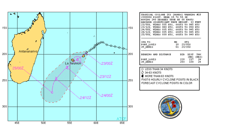
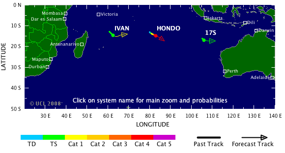
Hondo is een categorie4 geworden.
Geen enkel land is in zicht voor deze orkaan..
Geen enkel land is in zicht voor deze orkaan..
quote:Zware orkaan Hondo levert geen gevaar op
Woensdag is in de Indische Oceaan de orkaan Hondo in kracht toegenomen tot categorie 4.
De orkaan zorgt voor weinig gevaar. Met een snelheid van 7 kilometer per uur is het ruim 1350 kilometer verwijderd van het eiland Diego Garcia. Verder is er geen enkel eiland in de buurt te vinden. De komende dagen komt Hondo in koud water en neemt het systeem in kracht af.
www.vwkweb.nl
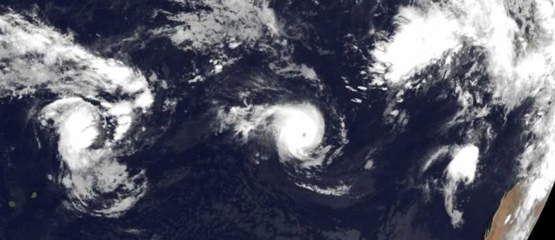


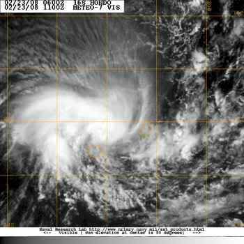
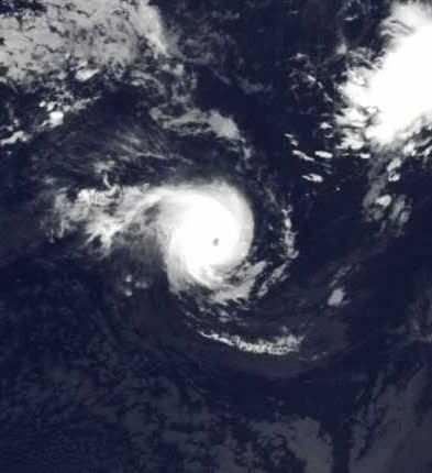
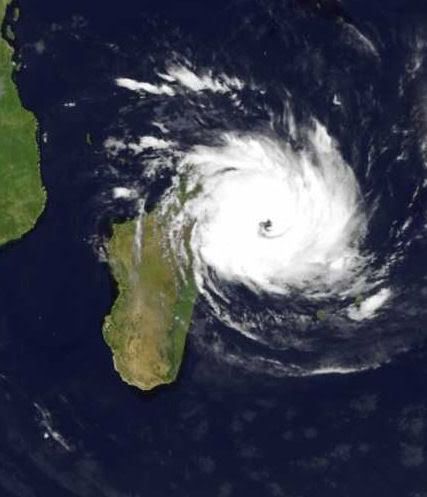
Cyclone Hondo
Cyclone Hondo was a powerful Category 4 storm when the Moderate Resolution Imaging Spectroradiometer (MODIS) on NASA’s Aqua satellite captured this photo-like image on the afternoon of February 7, 2008. The storm’s power is evident in its symmetric shape and well-defined eye. When MODIS took the image at 7:55 UTC, Hondo had winds of 220 kilometers per hour (140 miles per hour or 120 knots) with gusts to 270 km/hr (170 mph or 145 knots), said the Joint Typhoon Warning Center. The storm was traveling southeast across the southern Indian Ocean, far from any populated region.
Tropical Cyclone IVAN gaat nog flink in kracht toenemen.
Hondo komt in kouder water en verzwakt tot tropische depressie.
Hondo komt in kouder water en verzwakt tot tropische depressie.
Tropical Cyclone IVAN gaat recht op Madagascar af. (als cat. 1)
Tropical Storm NICHOLAS trekt richting Australie als cat.1
Tropical Storm NICHOLAS trekt richting Australie als cat.1
Hoeveel Cyclonen zal Madagascar nog krijgen dit seizoen...
IVAN gaat als een categorie 3 op het eiland af.
Neerslagverwachting rond de 22 centimeter.
IVAN gaat als een categorie 3 op het eiland af.
Neerslagverwachting rond de 22 centimeter.

quote:Very intense tropical cyclone Ivan struck Madagascar as an intense tropical cyclone at about 06:00 GMT on 17 February. Data supplied by the US Navy and Air Force Joint Typhoon Warning Center suggest that the point of landfall was near 17.1 S, 49.7 E. Ivan brought 1-minute maximum sustained winds to the region of around 185 km/h (114 mph). Wind gusts in the area may have been considerably higher.
According to the Saffir-Simpson damage scale the potential property damage and flooding from a storm of Ivan's strength (category 3) at landfall includes:
Storm surge generally 2.7-3.7 metres (9-12 feet) above normal.
Some structural damage to small residences and utility buildings with a minor amount of curtainwall failures.
Damage to shrubbery and trees with foliage blown off trees and large trees blown down.
Mobile homes and poorly constructed signs are destroyed.
Low-lying escape routes are cut by rising water 3-5 hours before arrival of the centre of the storm.
Flooding near the coast destroys smaller structures with larger structures damaged by battering from floating debris.
Terrain continuously lower than 1.5 metres (5 feet) above mean sea level may be flooded inland 13 km (8 miles) or more.
Evacuation of low-lying residences within several blocks of the shoreline may be required.
There is also the potential for flooding further inland due to heavy rain.
The information above is provided for guidance only and should not be used to make life or death decisions or decisions relating to property. Anyone in the region who is concerned for their personal safety or property should contact their official national weather agency or warning centre for advice.
Cyclone hits Madagascar, threatens Mozambique
ANTANANARIVO, Feb 18 (Reuters) - At least 11 people are thought to have died after Madagascar was hit by Cyclone Ivan, a senior humanitarian official said on Monday, and the storm is also threatening Mozambique.
Ivan, one of the largest cyclones ever to hit Madagascar, was packing winds of more than 125 mph (200 kph) when it hit the Indian Ocean island's east coast, causing the collapse of a hotel where nine people were sheltering.
"One of the victims called her father in Antananarivo on Sunday at 0830 (0530 GMT). Since then we have heard nothing," Jean Rakotomalala, executive secretary of the National Office of Disasters and Risk Management, told journalists.
His office later confirmed two more deaths in another district.
Rakotomalala said he had been unable to contact eight eastern districts, while strong rain hit the entire country, prompting fears of flooding also in the capital, Antananarivo.
"Cyclone Ivan is one of the strongest storms to have hit the Big Island," he said.
Last year, six cyclones killed 150 people on Madagascar, destroying homes and crops in the island's worst season on record.
The world's fourth largest island is prone to frequent cyclones and tropical storms. This season's first cyclone, Cyclone Fame, killed at least 13 people.
Madagascar is the world's largest producer of vanilla and 85 percent of its population were living on less than $2 per day in 2005, according to official data.
Mozambique's National Meteorological Institute (INAM) said Ivan, a category 4 storm, had strengthened over the Indian Ocean and was likely to cause damage when it reached the coast.
"We are monitoring the situation very closely before we issue an alert," INAM said in a statement.
INAM said Ivan had gathered winds of up to 90 mph (150 kph) and could strengthen further.
Mozambique, Zambia, Zimbabwe and Malawi have been lashed by heavy rain for weeks, causing rivers to burst their banks and forcing thousands of villagers to flee flooded homes.
Mozambique's worst disaster in recent memory occurred in 2000-2001 when a series of cyclones worsened widespread flooding in southern and central parts of the country, killing 700 people and driving close to half a million from their homes.
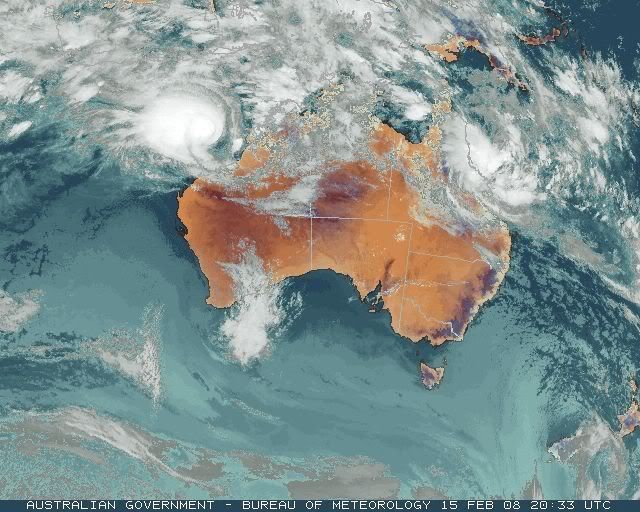
Coral Bay on cyclone red alert
THE West Australian Pilbara town of Exmouth emerged largely unscathed from battering by tropical cyclone Nicholas which has now veered away from the tourist centre.
But residents around Coral Bay have been put on red alert, warning them to remain indoors, as the weakening cyclone bears down.
Exmouth had been placed on red alert today with residents taking shelter from potentially destructive winds.
But the town withstood it well.
By 9pm (WDT) last night the category two cyclone was about 60km south-west and 90km north of Coral Bay, moving south at 11km/h, the Bureau of Meteorology (BOM) said.
The cyclone is very close to the coast, and although it is weakening, has wind gusts of up to 130km/h, which are expected to affect western coastal areas between North West Cape and Coral Bay.
Gales of up to 100km/h are affecting North West Cape now, and are expected to move south towards Coral Bay overnight. They could extend further south to Carnarvon tomorrow.
Higher-than normal tides are expected on the southern side of Exmouth Gulf and over west coastal parts between Coral Bay and North West Cape tonight, with very rough seas and possible flooding.
Fire and Emergency Services Authority West Pilbara district manager Peter Cameron said Exmouth emerged with no structural damage and minor power cuts caused by falling tree branches.
Wind gusts had reached about 110km/h earlier, but the town was well prepared for the onslaught and suffered no substantial damage.
"We have them (cyclones) every year and our communities are very well prepared. Our structures are rated to cyclone standards," he said.
"The system is weakening, so the destructive winds are decreasing."
Coral Bay is home to about 150 people, Mr Cameron said.
In 1999, Exmouth was hit by the strongest winds ever recorded on the Australian mainland, with severe tropical cyclone Vance generating a 267km/h blast that caused structural damaged to 10 per cent of buildings.

Madagascar zwaar getroffen door cycloon
Het dodental van een cycloon die zondag Madagascar trof is donderdag gestegen tot 26. De meeste doden vielen door overstromingen die door de cycloon werden veroorzaakt. De storm zelf kostte aan twee mensen het leven.
Veertienduizend mensen zijn hun huis kwijtgeraakt en veel rijstvelden zijn beschadigd. Sommige gebieden die zijn getroffen zijn nog altijd niet toegankelijk. Op Sainte Marie, een eiland voor de noordoostkust, zou 80 procent van de gebouwen zijn verwoest. Het eiland zit zonder water en stroom, zei een bewoner. De regering zal het buitenland waarschijnlijk om hulp vragen.
De cycloon, Ivan geheten, was de tweede van dit seizoen. Madagascar, het op drie na grootste eiland ter wereld, wordt geregeld getroffen door cyclonen en gevreesd wordt dat dit door het broeikaseffect nog erger zal worden.
Op zaterdag 15 augustus 2009 23:05 schreef eer-ik het volgende:
Ik vind je sig nogal denigrerend.
Ik vind je sig nogal denigrerend.