WKN Weer, Klimaat en Natuurrampen
Lees alles over het onstuimige weer op onze planeet, volg orkanen en tornado's, zie hoe vulkanen uitbarsten en hoe Moeder Aarde beeft bij een aardbeving. Alles over de verwoestende kracht van onze planeet en tal van andere natuurverschijnselen.


quote:Op maandag 1 oktober 2007 13:58 schreef Frutsel het volgende:
[..]
4 Orkanen die de VS troffen in november sinds 1900
http://www.usatoday.com/weather/huricane/whnovmajor.htm
Dus ik verwacht weinig tot geen problemen, hooguit een tropische storm met wat regenoverlast
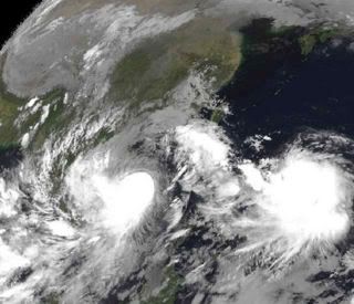
Een nieuwe orkaan is in de maak. Nu nog Tropical Depression 17W
Lekima heeft slachtoffers gemaakt
Lekima heeft slachtoffers gemaakt
quote:tropische storm Lekima treft de Filipijnen
Tropische storm Lelima heeft afgelopen weekend aan 9 mensen het leven gekost. De storm trok het afgelopen weekend over de Filipijnen.
De meeste mensen kwamen om het leven toen modderstromen een aantal huizen hebben verwoest in de stad Hingyon. De storm had een gemiddelde windsnelheid van 65 km/uur, Het was echter niet de wind maar de enorme hoeveelheden neerslag die de meeste schade heeft veroorzaakt. Het systeem is nu op weg naar Vietnam en kan daarbij weer iets in betekenis toenemen.
Wat een mega wolkencomplexen zijn dat zeg. Net zo groot als heel frankrijk, als het niet meer is.
Drugs are good mkay?


Typhoon Krosa
This colorful image reveals the wind structure within the quickly developing Typhoon Krosa. NASA’s QuikSCAT satellite captured the data used to make this image. Wind speeds are depicted in a rainbow of colors, with the highest speeds in purple and the slowest speeds in blue. The barbs show wind direction, and white barbs depict areas of heavy rain.
Though Krosa was a weak storm when QuikSCAT observed it at 9:48 UTC on October 2, 2007, its strengthening winds still have the classic bull’s eye shape observed in a strong storm. Sustained winds in the center of the storm ranged between 110 kilometers per hour (70 miles per hour or 60 knots) and 120 km/hr (75 mph or 65 knots), said the Joint Typhoon Warning Center. These wind speeds put the storm on the border between a tropical storm and a Category 1 typhoon. In this image, the strongest winds are depicted in purple and surround concentric rings of calm where an eye has clearly formed. The strong wind fields aren’t perfectly symmetric, and that is a sign that the storm was still forming.
Krosa initially formed over the western Pacific Ocean on October 1. The Joint Typhoon Warning Center predicted that the storm would grow into a powerful typhoon as it moved towards the China coast.
Measurements of the actual wind strength of cyclones are often higher than those measured by QuikSCAT. QuikSCAT employs a scatterometer, which sends pulses of microwave energy through the atmosphere to the ocean surface, and measures the energy that bounces back from the wind-roughened surface. The energy of the microwave pulses changes depending on wind speed and direction, giving scientists a way to monitor wind around the world. This technique does not work over land, but allows measurements in storms over oceans.
Tropical cyclones, however, are difficult to measure. To relate the radar energy that returns to the sensor to actual wind speed, scientists compare measurements taken from buoys and other ground stations to data the satellite acquired at the same time and place. Because the high wind speeds generated by cyclones are rare, scientists do not have corresponding ground information to know how to translate data from the satellite for wind speeds above 50 knots (about 93 km/hr or 58 mph). Also, the unusually heavy rain found in a cyclone distorts the microwave pulses in a number of ways, making a conversion to accurate wind speed difficult. Instead, the scatterometer provides a nice picture of the relative wind speeds within the storm and shows wind direction.

Uhh die orkaan gaat recht op shanghai af...en laat daar nou net komend weekend een formule 1 wedstrijd zijn. WTF
edit
Orkaan is te sloom, dus we zien F1 niet op een vliegende manier
edit
Orkaan is te sloom, dus we zien F1 niet op een vliegende manier
Drugs are good mkay?
Even afwachten hoe dat af gaat lopenquote:Op donderdag 4 oktober 2007 21:13 schreef Party_P het volgende:
Uhh die orkaan gaat recht op shanghai af...en laat daar nou net komend weekend een formule 1 wedstrijd zijn. WTF
edit
Orkaan is te sloom, dus we zien F1 niet op een vliegende manier
Strong typhoon targets Taiwan, China over weekend
TAIPEI, Oct 5 (Reuters) - Taiwan warned fishing boats and people going out of town for the weekend that a strong typhoon was expected to reach the island shortly after midnight, bringing heavy rains and high winds before moving on to China on Sunday.
Disaster authorities monitoring Typhoon Krosa's approach from the southeast issued land and sea warnings for most of Taiwan, pulling fishing boats back to port and asking weekend adventurers to avoid stormy beaches and mountains prone to mudslides.
British typhoon tracking system Tropical Storm Risk called Krosa a category 4 typhoon, the same size as Hurricane Katrina, which killed more than 1,700 people in the United States in 2005.
"We're calling this a strong storm," said Lin Kuan-chen, a Ministry of the Interior disaster centre inspector. "We expect high waves at the coast and downpours in the mountains."
Ferry services and flights to two outlying islands had stopped on Friday ahead of the storm, although other transportation was running on normal schedules, Lin said.
A major reservoir in northwestern Taiwan could overflow because of heavy rains, the disaster centre warned, urging people in the area to be on guard.
Krosa was 470 km off the coast of Taiwan as of 0215 GMT on Friday after picking up strength throughout the week, and was packing sustained winds of 184 kph (114 mph) and gusts of up to 227 kph, Taiwan's Central Weather Bureau reported.
In China, the Flood Control and Drought Relief Department in coastal Zhejiang province issued a notice ordering officials back to work from vacation to prepare for the typhoon, the government Web site www.china.com.cn reported.
China is on the tail end of a week-long national holiday, meaning there are likely to be more than the usual number of tourists in the province's coastal areas, the report said.
"Safeguarding the large number of individual tourists, especially those driving in private cars, independent travellers and other groups, has become the important task of each locality and department," it said.
Zhejiang was battered last year by Typhoon Saomai, the strongest China had seen in 50 years, and its coastal areas were drenched by Typhoon Wipha last month.
Krosa was expected to hit the province on Sunday or Monday, the report said, citing the Zhejiang weather bureau.
Krosa is the 15th storm of the season recorded by the weather bureau, which tracks the northwestern Pacific region.
Typhoons regularly hit China, Taiwan, the Philippines and Japan from late summer season through the end of the year, gathering strength from the warm waters of the Pacific or the South China Sea before weakening over land.

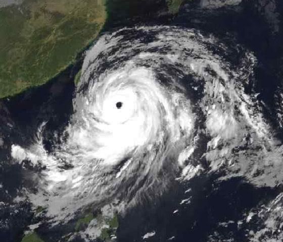
Typhoon Krosa
Typhoon Krosa was a powerful tropical storm system (the generic name for typhoon, hurricanes, and cyclones) on the morning of October 4, 2007. With sustained winds of over 210 kilometers per hour (130 miles per hour), it was just at the crest of being classified a Category Four Super Typhoon when NASA’s Aqua satellite flew over Krosa in the afternoon. The storm had been intensifying over the northeastern Philippine Sea for several days, and was expected, as of October 4, to head towards northern Taiwan and the Chinese mainland coast. The typhoon’s name, assigned by the Hong Kong Observatory, means crane in Khmer.
The Moderate Resolution Imaging Spectroradiometer (MODIS) on NASA’s Aqua satellite acquired this photo-like image at 12:40 p.m. local time (4:40 UTC) on October 4, 2007. A sprawling system with tightly wound spiral arms and a large though cloud-filled (“closed”) eye, Krosa bore all the hallmarks of a large and powerful Pacific typhoon. Although the storm was observed by MODIS to be brushing up against the Philippines, it was not projected to pass over the islands, though the outer bands will certainly bring rains to Luzon, the northernmost island in the Philippine chain.
Tientallen doden door tyfoon in Vietnam
(Novum/AP) - Overstromingen en aardverschuivingen in Vietnam als gevolg van tyfoon Lekima hebben zeker 32 levens gekost. Nog zestien mensen worden vermist en meer dan honderd zijn gewond. Dat hebben de autoriteiten zaterdag bekendgemaakt.
Lekima bereikte de kust van Vietnam op woensdag en beschadigde zo'n 77.000 huizen. De schade wordt geschat op 29 miljoen euro.
Doelijke tyfoon boven China verzwakt tot storm
BEIJING - Tyfoon Krosa heeft zondag het Chinese vasteland bereikt, maar nam daarna snel in kracht af. Dat meldden Chinese media.
De tyfoon kwam om 09.30 uur (Nederlandse tijd) aan land bij de dichtbevolkte provincies Zhejiang en Fujian in het zuidoosten van China. Krosa (Khmer voor kraanvogel) had toen nog windsnelheden tot 126 kilometer per uur. Voor zover bekend heeft de tyfoon daar geen slachtoffers gemaakt. Inmiddels is Krosa gedegradeerd tot een tropische storm.
Uit voorzorg waren 1,4 miljoen mensen geëvacueerd en tienduizenden vissersschepen teruggeroepen naar de haven, nadat de tyfoon op Taiwan zeker zeven mensen het leven had gekost.
In China is het vakantietijd, waardoor vooral zaterdag veel toeristen moesten vertrekken van eilanden voor de kust. Meerdere toeristische evenementen werden geschrapt, aldus Chinese media. Omdat Krosa in de metropool Shanghai voor problemen had kunnen zorgen, waren daar speciale draaiboeken uit de kast gehaald voor een goede doorgang van de Special Olympics, de Olympische Spelen voor mensen met een verstandelijke handicap.
Krosa had zaterdag het openbare leven in grote delen van Taiwan ontwricht. Bedrijven en instellingen bleven dicht, het openbaar vervoer lag grotendeels stil. De schade is volgens Aziatische media aanzienlijk. In meer dan twee miljoen huishoudens viel de stroom uit.
De schade door tyfoon Lekima, die eerder huishield in Azië, wordt steeds duidelijker. De Vietnamese autoriteiten meldden zondag zeker 37 doden en vijftien vermisten. Meer dan 70.000 huizen zijn verwoest.
Scientists a step closer to steering hurricanes click
By Tim Shipman in Washington
Last Updated: 3:17pm BST 22/10/2007
bron: telegraph uk
By Tim Shipman in Washington
Last Updated: 3:17pm BST 22/10/2007
bron: telegraph uk
NEW TROPICAL DEPRESSION POSSIBLE IN THE NORTHEAST CARIBBEAN
Just a quick update regarding the potential depression forming in the extreme northeast corner of the Caribbean Sea. The NHC continues to mention the possibility that this could indeed become a tropical depression over the next few days as it moves west-southwest. As of now, the system is producing very heavy rains and generally squally weather over portions of the Virgin Islands, Puerto Rico and northern Lesser Antilles. All of this activity is, in and of itself, enough of a nuisance that it need not be named in order to be a problem. Hopefully the entire mess will move on out of the area and take the foul weather with it. As I mentioned earlier tonight, there is some decent model support for this system to develop further and it might just become a depression or even a tropical storm before too long
Just a quick update regarding the potential depression forming in the extreme northeast corner of the Caribbean Sea. The NHC continues to mention the possibility that this could indeed become a tropical depression over the next few days as it moves west-southwest. As of now, the system is producing very heavy rains and generally squally weather over portions of the Virgin Islands, Puerto Rico and northern Lesser Antilles. All of this activity is, in and of itself, enough of a nuisance that it need not be named in order to be a problem. Hopefully the entire mess will move on out of the area and take the foul weather with it. As I mentioned earlier tonight, there is some decent model support for this system to develop further and it might just become a depression or even a tropical storm before too long
Tropical storm forms near Haiti
MIAMI, Florida (AP) -- Tropical Storm Noel has formed in the Caribbean, the U.S. National Hurricane Center said Sunday.
The storm was moving northwest across the Caribbean on Sunday, prompting storm warnings in Haiti and watches in Cuba and Jamaica, where it could bring more than 10 inches of rain, forecasters said.
A tropical storm warning was in effect for the southwestern peninsula of Haiti from the Haiti-Dominican Republic border westward to Port-au-Prince, meaning tropical storm conditions are expected within the next 24 hours.
The governments of Jamaica and Cuba issued tropical storm watches in their countries.

Tropische storm Noel bij Hispaniola
Ten zuiden van Hispaniola (de landen Haiti en de Dominicaanse Republiek) heeft zich tropische storm Noel gevormd.
Noel is de 14e tropische storm van het Atlantische seizoen 2007. De storm gaat gepaard met veel neerslag, en vooral Haiti moet vrezen voor modderstromen. In dat land zijn in het verleden meermalen veel slachtoffers gevallen door modderlawines bij orkanen en tropische stormen. De zware buien waaruit Noel ontstond eisten de afgelopen dagen al enkele mensenlevens in Puerto Rico.
De storm trekt naar verwachting over de westhelft van Haiti. Over de verdere koers lopen de verschillende weermodellen nogal uiteen: of richting Cuba, of afbuigend naar de Bahama's.
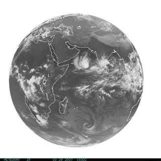
Tropical Storm 05A heeft zich gevormd in de Indische Oceaan
[ Bericht 6% gewijzigd door #ANONIEM op 28-10-2007 22:53:31 ]
Ten zuiden van Hispaniola (de landen Haiti en de Dominicaanse Republiek) heeft zich tropische storm Noel gevormd.
Noel is de 14e tropische storm van het Atlantische seizoen 2007. De storm gaat gepaard met veel neerslag, en vooral Haiti moet vrezen voor modderstromen. In dat land zijn in het verleden meermalen veel slachtoffers gevallen door modderlawines bij orkanen en tropische stormen. De zware buien waaruit Noel ontstond eisten de afgelopen dagen al enkele mensenlevens in Puerto Rico.
De storm trekt naar verwachting over de westhelft van Haiti. Over de verdere koers lopen de verschillende weermodellen nogal uiteen: of richting Cuba, of afbuigend naar de Bahama's.
Tropical Storm 05A heeft zich gevormd in de Indische Oceaan
[ Bericht 6% gewijzigd door #ANONIEM op 28-10-2007 22:53:31 ]

Tropical Storm Noel
Tropical Depression 16 was intensifying into Tropical Storm Noel late in the morning of October 28, 2007, when the Moderate Resolution Imaging Spectroradiometer (MODIS) on NASA’s Terra satellite captured this image. Though still weak, the storm was beginning to take the distinct shape of a tropical cyclone. A dense circle of clouds converged over the Caribbean Sea just south of Haiti and the Dominican Republic, and a long tail of clouds curled over Puerto Rico. Shadows cast by towering thunderstorm clouds make the cloud layer appear to be boiling in places.
At the time this image was acquired, Noel had winds of 65 kilometers per hour (40 miles per hour or 35 knots) with gusts to 83 km/hr (52 mph, 45 knots), said the National Hurricane Center. Despite relatively low wind speeds, the storm posed a serious threat to Hispaniola, the island encompassing the Dominican Republic and Haiti. The National Hurricane Center expected Noel to dump between 250 and 500 millimeters (10 and 20 inches) of rain on the island, with a few isolated areas receiving up to 760 mm (30 inches) of rain. The heavy rainfall has the potential to trigger deadly floods and mudslides. Tropical Storm Jeanne was just a tropical storm when its heavy rain caused extensive floods and mudslides that killed at least 1,500 Haitians in September 2004. Haiti is particularly vulnerable to flash flooding and landslides because of the widespread deforestation of its mountainous terrain.
Noël eist levens op Dominicaanse Republiek
(Novum/AP) - De tropische storm Noel heeft op de Dominicaanse Republiek maandag hevige onweersbuien en overstromingen veroorzaakt. Volgens hulpdiensten kwamen daarbij minstens twintig mensen om.
Minstens twintig andere mensen worden nog vermist. Verwacht wordt dat nog minstens vijftig centimeter regen zal vallen op Hispaniola - het eiland waarop Haïti en de Dominicaanse Republiek liggen - voordat Noel in noordwestelijke richting naar de Bahamas trekt. Volgens de hulpdiensten werden veel mensen verrast door de hevigheid van de regenval. Veel slachtoffers kwamen om door verdrinking. De verwachting is dat het dodental zal stijgen als meldingen binnenkomen uit afgelegen gebieden.
De premier van Haïti, Jacques Edouard Alexis, zei op een persconferentie dat er nog geen meldingen waren van slachtoffers. De premier deed een oproep aan alle burgers om hun huizen te verlaten en een schuilplaats te zoeken en kondigde aan dat vliegvelden de hele dag dicht blijven.
Dodental tropische storm Noel gestegen
SANTO DOMINGO - Het dodental als gevolg van de tropische storm Noel is in de Dominicaanse Republiek en Haïti opgelopen tot zeker veertig. Enkele inwoners worden nog vermist. De wind en regen van Noel teisterden dinsdag Cuba en bewogen zich daarna in de richting van de Bahamas.
Noel maakte maandag het Caribische eiland Hispaniola onveilig toen hij windsnelheden van 75 kilometer per uur bereikte. Rivieren traden buiten hun oevers en veroorzaakten enorme overstromingen. Vele duizenden families sloegen op de vlucht voor het natuurgeweld. Op sommige plekken stond in korte tijd meer dan een halve meter water in huizen.
De situatie blijft moeilijk en de schade is erg groot. Zeker tien bruggen zijn ingestort en ruim 6000 woningen zijn beschadigd. Ook vele bananen-, tomaten- en uienplantages zijn verwoest.
SANTO DOMINGO, Dominican Republic — Tropical Storm Noel triggered mudslides and floods in the Dominican Republic and Haiti, pushing the death toll to 80 on Wednesday and forcing some parents to choose which of their children to save from the surging waters.
The storm lurched out of Cuba and stalled over the ocean, but was projected to skirt Florida and batter the Bahamas, the U.S. National Hurricane Center said. A tropical storm watch was issued for parts of southeast Florida.
With rain still falling two days after the storm hit, rescuers were struggling to reach communities cut off by flooding on the island of Hispaniola. As they did, they found a rising toll of death and damage — at least 51 dead in the Dominican Republic, 28 in Haiti and one in Jamaica.
Floods inundated the small town of Bonao, forcing Charo Vidal into a tree late Tuesday. She watched her neighbor struggle to do the same nearby, clutching infant twins while she climbed as the waters swept an older daughter away.
"She couldn't take care of all three," Vidal said. "That is something very significant, to have a child snatched from your hands and you cannot do anything for them."
A man who carried his 6-year-old son on his back also lost him to the flood, Vidal said.
"The child said, 'Daddy, I'm slipping. Daddy, I'm slipping,"' Vidal said.
"A lot of people had to choose between losing one child and losing another one," said Liony Batista, a project manager for Food for the Poor, an international Christian relief organization. Batista said 200 homes were destroyed in Bonao alone.
At least 50,500 Dominicans fled their homes, 12,000 of which were damaged, said Luis Antonio Luna, head of the Emergencies Commission. Flooding also forced the evacuation of about 1,000 prisoners from a prison north of the Dominican capital.

Het wordt dus alsnog een orkaan 
ASSAU, Bahamas — A powerful Caribbean storm drenched the Bahamas and Cuba while rescue workers in the Dominican Republic headed out in boats and helicopters to reach dozens of communities isolated by floods and mudslides. The death toll rose to 115.
Noel was upgraded to a hurricane Thursday evening. But it did most of its damage as a tropical storm as it became the year's deadliest tempest in the Atlantic region. Hurricane Felix, a devastating Category 5 storm, killed 101 people when it lashed the Caribbean and slammed into the Nicaraguan and Honduran coasts in early September.
Hurricane Noel's sustained winds had increased to 80 mph (129 kph) late Thursday night as it moved away from the Bahamas, the National Weather Service said.
Earlier Thursday, muddy rain-swollen waters overflowed a dam in Cuba, washing into hundreds of homes, over highways and knocking out electricity and telephone service. Dozens of small communities were cut off.
Cuban soldiers went door-to-door in low-lying areas and evacuated about 24,000 people, according to state radio and television reports. At least 2,000 homes were damaged by floodwaters, but there was no official word of deaths.
http://www.foxnews.com/story/0,2933,307157,00.html
ASSAU, Bahamas — A powerful Caribbean storm drenched the Bahamas and Cuba while rescue workers in the Dominican Republic headed out in boats and helicopters to reach dozens of communities isolated by floods and mudslides. The death toll rose to 115.
Noel was upgraded to a hurricane Thursday evening. But it did most of its damage as a tropical storm as it became the year's deadliest tempest in the Atlantic region. Hurricane Felix, a devastating Category 5 storm, killed 101 people when it lashed the Caribbean and slammed into the Nicaraguan and Honduran coasts in early September.
Hurricane Noel's sustained winds had increased to 80 mph (129 kph) late Thursday night as it moved away from the Bahamas, the National Weather Service said.
Earlier Thursday, muddy rain-swollen waters overflowed a dam in Cuba, washing into hundreds of homes, over highways and knocking out electricity and telephone service. Dozens of small communities were cut off.
Cuban soldiers went door-to-door in low-lying areas and evacuated about 24,000 people, according to state radio and television reports. At least 2,000 homes were damaged by floodwaters, but there was no official word of deaths.


http://www.foxnews.com/story/0,2933,307157,00.html
Laat em af buigen naar NL graag 
Doe mee met het voorspellen van het weer!
Weekvoorspelling | Week 39 (Inschrijven tot 22-9, 11:59)
Maandvoorspelling | September (Gesloten)
Jaarvoorspelling 2024 / 2025
Weekvoorspelling | Week 39 (Inschrijven tot 22-9, 11:59)
Maandvoorspelling | September (Gesloten)
Jaarvoorspelling 2024 / 2025
Ik geloof die voorspelling niet zo.quote:Op vrijdag 2 november 2007 08:14 schreef Light het volgende:
Noel wil wel veel van de wereld zien.
[ afbeelding ]
Wel grappig om te zien dat die orkaan (dat is nu al toch) aan het eilandhoppen is.
Ik zag een plaatje vanmiddag,
waar Noel af zou buigen naar IJsland.
Dat komt natuurlijk nooit uit.
waar Noel af zou buigen naar IJsland.
Dat komt natuurlijk nooit uit.
Life is Music

Noel
Dostojewski: "Je kunt je niet van je eigen gezond verstand overtuigen door je buurman op te sluiten."
Hij gaat ook richting IJsland en daarna Scandinavie, dacht ik.quote:Op vrijdag 2 november 2007 19:19 schreef Fredo55 het volgende:
Ik zag een plaatje vanmiddag,
waar Noel af zou buigen naar IJsland.
Dat komt natuurlijk nooit uit.

Noreaster Noel

91L bij Nicaragua, die daar voor veel neerslag kan gaan zorgen.
Dostojewski: "Je kunt je niet van je eigen gezond verstand overtuigen door je buurman op te sluiten."
http://www.atl.ec.gc.ca/w(...)04160318.Noel.txt.enquote:WOCN31 CWHX 041600
POST-TROPICAL STORM NOEL INTERMEDIATE INFORMATION STATEMENT
ISSUED BY THE CANADIAN HURRICANE CENTRE OF ENVIRONMENT CANADA
AT 12.00 NOON AST SUNDAY 04 NOVEMBER 2007.
THE NEXT STATEMENT WILL BE ISSUED BY 3.00 PM AST
AT 11.00 AM AST... POST-TROPICAL STORM NOEL WAS LOCATED NEAR
LATITUDE 49.7 N AND LONGITUDE 62.8 W... ABOUT 45 NAUTICAL MILES
OR 83 KM SOUTHWEST OF NATASHQUAN QUÉBEC.
NOEL IS MOVING RAPIDLY TOWARDS THE NORTHEAST AT ABOUT 45 KNOTS...
83 KM/H. MAXIMUM SUSTAINED WINDS ARE ESTIMATED AT 60 KNOTS... 111
KM/H AND CENTRAL PRESSURE AT 968 MB.
HIGHEST WINDS REPORT INCLUDE 180 KM/H AT WRECKHOUSE NEWFOUNDLAND..
AND 135 KM/H AT MCNABS ISLAND AND BEAVER ISLAND NOVA SCOTIA.
HEAVIEST RAINFALLS REPORTED INCLUDE 130 MM AT SMELT BROOK IN CAPE
BRETON NOVA SCOTIA AND 111 MM IN CENTRAL NEW BRUNSWICK.
IN GENERAL NEW BRUNSWICK WAS THE HARDEST HIT WITH RAIN WITH ALL
STATIONS ACROSS THE PROVINCE REPORTING AT LEAST 50-80 MM.
NOVA SCOTIA WAS THE HARDEST HIT WITH WIND AND MOST STATIONS
REPORTED OVER 100 KM/H GUSTS AND SEVERAL STATIONS REPORTED HURRICANE
FORCE GUSTS IN EXCESS OF 120 KM/H.
REPORTS OF DAMAGE AND POWER OUTAGES AROUND NOVA SCOTIA ARE
CONTINUING TO BE RECEIVED.
END BOWYER

nu bij provincie Newfoundland en Labrador
http://www.nu.nl/news/130(...)doet_Canada_aan.htmlquote:Wervelwind Noel doet Canada aan
Uitgegeven: 4 november 2007 14:31
Laatst gewijzigd: 4 november 2007 14:39
HALIFAX - Ruim 150.000 Canadezen kwamen zondag zonder stroom te zitten, nadat wervelstorm Noel het oosten van Canada aandeed. Veel kabels en leidingen braken door het slechte weer.
anp
De schade was het grootst in de provincie Nova Scotia. Op het vliegveld van proinciehoofdstad Halifax bleven zaterdagavond uit veiligheidsoverwegingen zeker veertig vliegtuigen aan de grond staan. Het nationale orkaancentrum heeft ook andere provincies gewaarschuwd voor storm.
Doden
Wervelwind Noel heeft al meer dan honderd doden op zijn geweten in de Dominicaanse Republiek, Haïti en Jamaica.
Dostojewski: "Je kunt je niet van je eigen gezond verstand overtuigen door je buurman op te sluiten."
Tropical Storm Peipah op weg naar Vietnam
Pff...vietnam..daar hebben ze al zoveel rotzooi gehad dit jaar
zie ook --> Tientallen doden door overstromingen Vietnam
[ Bericht 16% gewijzigd door Frutsel op 05-11-2007 09:13:30 ]
Pff...vietnam..daar hebben ze al zoveel rotzooi gehad dit jaar
zie ook --> Tientallen doden door overstromingen Vietnam
[ Bericht 16% gewijzigd door Frutsel op 05-11-2007 09:13:30 ]

Dit is het laatste bericht dat ik erover zag:quote:Op zondag 4 november 2007 16:27 schreef Docker het volgende:
Is noel dood? ik zie um niet meer op de radar
http://www.nu.nl/news/130(...)doet_Canada_aan.html
Op zaterdag 15 augustus 2009 23:05 schreef eer-ik het volgende:
Ik vind je sig nogal denigrerend.
Ik vind je sig nogal denigrerend.
Zo te zien krijgen we hier in nederland binnenkort ook een zware tropische storm!quote:November kent eerst een korte periode van rustig weer onder invloed van een hogedrukgebied. Dit is echter stilte voor de (eerste) zware storm, die tussen 8 en 13 november wordt verwacht. Er bestaat een kans van 80% dat deze over Nederland trekt, met windstoten van 145 tot 175 km/uur. Hierna wisselen koudere en zachtere perioden elkaar af, terwijl zich op de Atlantische Oceaan t.g.v. aangevoerde tropische lucht een zich uitdiepende depressie ontwikkelt. Er omheen vormen zich randstoringen en een zeer actief (kou) front. Het gevolg is een verschijnsel dat zich als een superstorm laat beschrijven; een exemplaar dat groter zal zijn dan de storm van 1987 en die van 1703. Deze superstorm wordt tussen 24 en 28 november verwacht. De bijbehorende diepe troglijnen zullen voor orkaankracht kunnen zorgen. Er worden windstoten van meer dan 200 km/uur verwacht! De kans dat deze storm over Nederland trekt wordt ook op 80% geschat. T.g.v. de grote onstabiliteit van de atmosfeer zijn tornado's niet uitgesloten. Eind november zal deze superstorm langzaam uitdoven, terwijl het stormachtig en nat blijft. Maar begin december lijkt het kouder te worden met kans op sneeuw.
- Piers Corbijn (vertaald door Piet Paulusma)
De kans is 80 tot 85 procent dat deze voorspelling uitkomt.
Nee áls die storm er komt schat die kerel de kans op 80% dat Nederland getroffen wordt. Het is lang niet zeker dat die storm er komt.
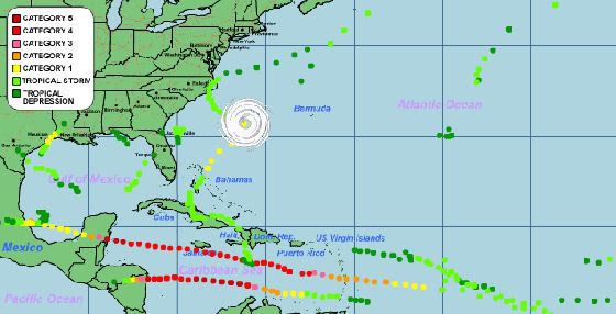
Alle stormen in de Atlantische Oceaan dit seizoen.
In Australie begint het orkaanseizoen ook weer.
In Australie begint het orkaanseizoen ook weer.
quote:Zwaar orkaanseizoen verwacht voor Australië
Engelse orkaandeskundigen verwachten dat Australië te maken krijgt met het zwaarste orkaanseizoen sinds 1998-1999. De oorzaak is La Nina.
Het orkaanseizoen bij Australië speelt zich af in de periode november tot en met april. De verwachting is dat er 13 tropische systemen tot ontwikkeling komen. Zeven systemen worden zwaar en zes komen aan land. Volgens de Australische meteorologische dienst moeten de Australiërs deze verwachting serieus nemen.

Tropical Cylone Sidr
Tropical Cyclone Sidr was gathering strength when the Moderate Resolution Imaging Spectroradiometer (MODIS) on NASA’s Terra satellite captured this photo-like image on November 12, 2007. The storm’s swirling clouds straddle the center of the Bay of Bengal with the eastern shores of Sri Lanka and India forming the left edge of the image. At the time that this image was taken, Sidr was relatively small, with sustained winds estimated at 100 kilometers per hour (60 miles per hour or 55 knots), the equivalent of an Atlantic tropical storm. Despite its small size, Sidr is well-formed with a dark spot near the center where an eye may be developing surrounded by tight bands of clouds. On November 12, the Joint Typhoon Warning Center forecast that Sidr would grow to the equivalent of a Category 2 storm, with sustained winds of 170 km/hr (100 mph or 90 knots) by November 14.
ik niet begrijp...
hoe kun je op twaalf november nou een image posten van dertien november, of is dat plaatje van Weather Underground geen actuele situatie? Daarnaast geeft Weather Underground een cat 4 aan, maar in het bericht hierboven wordt gesproken van maximaal cat 2 op 14 november
hoe kun je op twaalf november nou een image posten van dertien november, of is dat plaatje van Weather Underground geen actuele situatie? Daarnaast geeft Weather Underground een cat 4 aan, maar in het bericht hierboven wordt gesproken van maximaal cat 2 op 14 november
Het plaatje hierboven is een satelietfoto van 12 november... zij gebruiken andere meetapparatuur en bronnen denk ik. Dat plaatje daarboven is een 'live-pic'...die wordt om de zoveel uur geupdate... das ook een 'gif'...quote:Op dinsdag 13 november 2007 12:44 schreef Ared het volgende:
ik niet begrijp...
hoe kun je op twaalf november nou een image posten van dertien november, of is dat plaatje van Weather Underground geen actuele situatie? Daarnaast geeft Weather Underground een cat 4 aan, maar in het bericht hierboven wordt gesproken van maximaal cat 2 op 14 november
Waarom de ene een cat.2 aangeeft en de andere een cat 4 is me ook een raadsel....
Enige verklaring die ik heb is dat op het moment van het nemen van de foto, op de 12e, gistermorgen dus, er sprake zou zijn van een cat 2. (Hij was toen net een cat.1)
Echter is hij onverwachts in 24 uur uitgegroeid naar een cat 3, mogelijk naar cat.4...
dus als ik gisteren had gekeken stond daar een plaatje van 12 november en als ik vanavond kijk staat daar een plaatje van de situatie op 13 november om 11 PM?quote:Op dinsdag 13 november 2007 12:48 schreef Frutsel het volgende:
Dat plaatje daarboven is een 'live-pic'...die wordt om de zoveel uur geupdate... das ook een 'gif'...
jepquote:Op dinsdag 13 november 2007 12:55 schreef Ared het volgende:
[..]
dus als ik gisteren had gekeken stond daar een plaatje van 12 november en als ik vanavond kijk staat daar een plaatje van de situatie op 13 november om 11 PM?
weet niet om de hoeveel uur ze dat updaten, maar hij blijft verversen zeg maar
Alhoewel... ik zie dat ie nu cat.4 is... op het bericht op de FP was ie nog cat.3 , kijk maar --->
Tyfoon Sidr op weg naar Bangladesh & India
Dat plaatje is opgeslagen en wordt niet ververst, deze wel.. das een 'live-link' naar de website zeg maar.