WKN Weer, Klimaat en Natuurrampen
Lees alles over het onstuimige weer op onze planeet, volg orkanen en tornado's, zie hoe vulkanen uitbarsten en hoe Moeder Aarde beeft bij een aardbeving. Alles over de verwoestende kracht van onze planeet en tal van andere natuurverschijnselen.


Overstromingen dreigen voor Queensland
Hevige regen teistert momenteel het kustgebied van Queensland. Er wordt hierdoor gevreesd voor nieuwe overstromingen in het gebied wat in januari ook al getroffen is door noodweer.
WKN / Noodweer treft Queensland
Er wordt ook gewaarschuwd voor de wind die kan oplopen tot 130 km/u. Dit is vergelijkbaar met de kracht van een orkaan, waardoor bomen en electriciteitspalen kunnen sneuvelen.
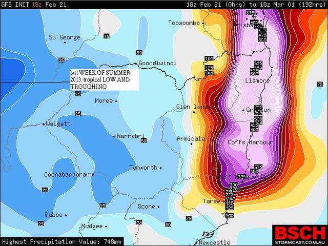
De neerslagkaart hieronder laat de som zien van 22 t/m 25 februari. De totale hoeveelheid kan plaatselijk oplopen tot boven de 400 mm.
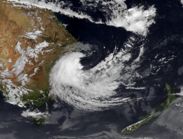
Satellietbeeld van 6 uur deze ochtend.
Hevige regen teistert momenteel het kustgebied van Queensland. Er wordt hierdoor gevreesd voor nieuwe overstromingen in het gebied wat in januari ook al getroffen is door noodweer.
WKN / Noodweer treft Queensland
Er wordt ook gewaarschuwd voor de wind die kan oplopen tot 130 km/u. Dit is vergelijkbaar met de kracht van een orkaan, waardoor bomen en electriciteitspalen kunnen sneuvelen.
De neerslagkaart hieronder laat de som zien van 22 t/m 25 februari. De totale hoeveelheid kan plaatselijk oplopen tot boven de 400 mm.

Satellietbeeld van 6 uur deze ochtend.

quote:Incredible winds being felt along the NE NSW coast today as the LOW approaches. A 126km/h wind gust was recorded at Cape Byron at 12.14pm today - equivalent to that of a Category One Cyclone. Further destructive winds are likely. This is a shot from outside the Ballina Visitor Information Centre uploaded by Ballina Coast and Hinterland
http://www.wunderground.c(...)53&page=9#commenttop


Hmmm... als het maar niet zon drama wordt als in december 2010 en januari 2011 
WKN / Overstromingen Australie: Ergste in honderd jaar
WKN / Overstromingen Australie: Ergste in honderd jaar

quote:One killed in Queensland flooding
A Sunshine Coast man has died trying to cross a flooded road at Kilcoy, north of Brisbane, as heavy rain continues across south-east Queensland.
Emergency services were called to Mary Smokes Creek Road just before 4pm AEST after a person witnessed a vehicle sinking in rising flood waters.
A short time later, police retrieved the body of a man in his 60s.
Police say the death is a tragic reminder of the dangers of crossing flooded causeways.
South-east Queensland is on flood alert as the weather bureau predicts up to 200 millimetres of rain will fall in the next 24 hours.
Audio: Severe weather warning for Qld's south-east (PM)
The bureau's senior forecaster Michelle Berry says heavy falls have already drenched the region.
"We've actually seen around 80 millimetres recorded in Toowoomba now since 9am (AEST), so that's particularly heavy rainfalls occurring through there," she said.
"Also similar totals around that Sunshine Coast hinterland and Esk area."
While the rain is nowhere near as heavy as that recorded during the Australia Day long weekend when ex-cyclone Oswald caused widespread flooding, authorities are still warning that flash flooding is possible from Bundaberg south to Brisbane.
Fraser Coast Mayor Gerard O'Connell says residents are worried by this latest rainfall.
"This is a bit of a depressing sight quite frankly," he said.
"After four weeks where we had the chance to overcome severe weather of the Australia Day weekend, now we're facing up to the prediction of really, really heavy rain.
"What we're seeing from the Bureau of Meteorology at the moment is rainfall in the vicinity of 100 to 200 millimetres.
"And that's fairly significant and it's going to see localised flooding and, of course, roads will be cut."
Brisbane City Council is keeping watch and providing sandbags to residents, but it is hoping the slow-moving rain depression means less chance of flooding.


|
|