WFL Wetenschap, Filosofie, Levensbeschouwing
Discussieer hier over alle aspecten van de wetenschap, filosofische problemen en zaken van levensbeschouwelijke aard.


Orkaan Andrew heeft vlak voor dat hij Florida flink aan kracht toegenomen omdat de waters rond de Bahamas eilanden en voor de kust van Florida erg warm zijn.
Orkaan Andrew heeft Florida ook geteisterd als een categorie 4 orkaan. Pas in het jaar 2002 (10 jaar na de ramp) na vele studies hebben deskundigen orkaan Andrew gekwalificeert alsr een categorie 5 orkaan gezien de enorme schade en de windsnelheden die geregistreerd werden.
Orkaan Andrew heeft Florida ook geteisterd als een categorie 4 orkaan. Pas in het jaar 2002 (10 jaar na de ramp) na vele studies hebben deskundigen orkaan Andrew gekwalificeert alsr een categorie 5 orkaan gezien de enorme schade en de windsnelheden die geregistreerd werden.
Frances is een categorie 4 orkaan met vaste windsnelheden nabij het centrum van 145 mijl per uur. Een categorie 5 orkaan heeft windsnelheden van meer dan155 mijl per uur. Frances heeft 10 mijl tekort aan windsnelheden om een categorie 5 orkaan te worden. Er werden eerder wel rukwinden geregistreert van 165 mijl per uur door de hurricane hunters vliegtuig (vliegtuig die door de oorkaan vliegt om metingen te verichten)
Dit lees ik net nog... Het is volgens FOX/ABC/CNN nog steeds een Categorie 4.
With homes still swaddled in blue tarp and the deaths from Hurricane Charley still fresh in their minds, Florida residents lined up before dawn Thursday for supplies or made evacuation plans as they braced for what could be the mightiest storm of the season
Frances is just as strong as Hurricane Charley (search), which devastated Florida's southwest coast Aug. 13, but twice the size, said Stephen Baig, a forecaster at the National Hurricane Center (search) in Miami. Frances was also about twice the size of 1992's Hurricane Andrew, which
destroyed much of southern Miami-Dade County.
Forecasters said it could become a Category 5 with winds of 156 mph or higher by the time it makes landfall. The difference wasn't something residents spent time discussing.


2 models (NOCAPS and BAM) predict landfall of hurricane Frances near Miami/Ft Lauderdale and its metro area. UKMET model brings the center of hurricane Frances near Orlando and its metro area.
Bulletin van de National Hurricane Center in Miami 10:00am nederlands tijd.
an Air Force Reserve hurricane hunter aircraft monitoring Frances
reports a central pressure of 936 mb and maximum flight-level winds
of 138 kt at 700 mb. A dropsonde in the northeastern eyewall
reported winds indicating surface winds near 125 kt...and that is
the initial intensity for this advisory. This is in good agreement
with 127 kt satellite intensity estimates from TAFB...SAB...and
AFWA. Satellite imagery indicates cooling of the cloud tops since
06z...although at the moment this convection is rather asymmetric.
The initial motion is 290/11. Frances continues on the southwest
side of the subtropical ridge...a feature that the large-scale
models are having a problem forecasting the evolution of. The
synoptic surveillance mission yesterday seems to have had little
effect on the models...as the GFS and GFDL still want to turn
Frances more northward....while the NOGAPS and UKMET still forecast
a west-northwestward motion across Florida into the Gulf of Mexico.
Given this lack of change...the only change in the forecast track
during the first 72 hr is based on the initial position and current
motion...with this part of the track in best agreement with the
NOGAPS. After 72 hr...the track is shifted westward toward the
UKMET and NOGAPS forecasts. The forecast track calls for landfall
in southeast or east central Florida in just over 48 hr.
However...people should not focus too closely on the exact track...
as small changes in direction could make a significant difference
in the landfall location.
Frances continues to show impressive outflow...although it may be
decreasing a little in the northwestern quadrant. The intensity of
Frances continues to be controlled by concentric eyewall cycles.
Since these are difficult to forecast...the intensity forecast will
call for 125 kt intensity until landfall. Given the current cloud
top cooling...Frances could reach 130-135 kt intensity on the up
side of the current cycle.
The southward shift in the forecast track requires the Hurricane
Watch to be extended southward into the upper Florida Keys. A
Hurricane Warning is not being issued for southeastern Florida at
this time as the 24 hr forecast keeps the tropical storm winds
offshore. However...hurricane warnings are likely on the next
advisory.
Forecaster Beven
Als het de nogaps maar niet volg want dan heeft in een keer 3 kwart van me familie er last van. Maja moeten ze in de bunker enzo. Maargoed ff hopen dat het niet al te shit wordt
Powered by Garmin Etrex Legend
Hurricane Frances Downgraded from Categorie 4 to 3
ST. AUGUSTINE, Florida (CNN) -- Florida residents in the path of Hurricane Frances boarded up their homes and jammed highways and airports Thursday to escape the massive storm.
Some 2.5 million people are in evacuation areas, Gov. Jeb Bush said. He declared a state of emergency in advance of the Category 3 storm.
The storm was downgraded from a Category 4 to a Category 3 hurricane late Thursday night, as winds decreased from 140 mph (220 kph) to 125 mph (205 kph).
"Don't read too much into that because that's still a very dangerous Category Three hurricane on the Saffir-Simpson scale," said Max Mayfield, director of the National Hurricane Center in Miami. "We may well gain some of that strength back in the next 24 hours."
Hurricanes are classified as categories 1 to 5 on the Saffir-Simpson hurricane scale. A Category 3 storm has winds of 111 to 130 mph (178 to 209 kph).
The eye of the hurricane was 330 miles (530 kilometers) east-southeast of Florida's lower east coast and about 25 miles east-southeast of Cat Island in the Bahamas, moving west-northwest at about 10 mph (17 kph). The storm is expected to move forward at a slower speed in the next 24 hours as it passes over the Bahamas.
Forecasters said the storm could begin lashing the southeast Florida coast Friday afternoon with strong winds and heavy rain, but the full brunt of the storm would likely be a few hours later.
Up to 20 inches of rain was possible, said Mayfield. He predicted "massive power outages" over the Florida peninsula.
The National Hurricane Center issued a hurricane warning Thursday for most of Florida's east coast, from Florida City north to Flagler Beach.
Mayfield said meteorologists still don't know exactly where the storm will make landfall, "but everything we see says we have a good hurricane track forecast."
"Those strong winds and heavy rain will go rolling across the peninsula," he told reporters Thursday night.
Frances threatened to be much more dangerous than Hurricane Charley, which killed 25 people, Ed Rappaport, the center's deputy director, said.
"This is a much bigger storm than Charley was, maybe two to three times the size," Rappaport said. "There'll be a large area of damage when this comes ashore."
Rappaport said that Frances was also a larger storm than Hurricane Andrew, the devastating Category 5 storm that crushed South Florida in 1992.
"It is likely to be a much wetter storm than Andrew was," he said. "One reason is that it's bigger than Andrew and another is that it's more slowly moving."
A hurricane watch and tropical storm warning are in effect for the middle and upper Florida Keys from south of Florida City to the Seven Mile Bridge.
Orkaan Frances bedreigt miljoenen Amerikanen
De Amerikaanse staat Florida wacht met angst en beven op de komst van de orkaan Frances.
Grootse Evacuatie Ooit - 2,5 miljoen mensen
De autoriteiten van Florida hebben 2,5 miljoen inwoners opgeroepen hun huizen te ontvluchten. De enorme tropische storm raasde de afgelopen dagen met windsnelheden tot 205 kilometer per uur over de Bahama's en zal komende weekend naar verwachting de oostkust van de VS teisteren.
Files
De evacuatie is de grootste in de geschiedenis van Florida. Op tv-beelden was te zien hoe snelwegen volstroomden met mensen die de naderende orkaan probeerden te ontwijken.
De Amerikaanse staat Florida wacht met angst en beven op de komst van de orkaan Frances.

Grootse Evacuatie Ooit - 2,5 miljoen mensen
De autoriteiten van Florida hebben 2,5 miljoen inwoners opgeroepen hun huizen te ontvluchten. De enorme tropische storm raasde de afgelopen dagen met windsnelheden tot 205 kilometer per uur over de Bahama's en zal komende weekend naar verwachting de oostkust van de VS teisteren.
Files
De evacuatie is de grootste in de geschiedenis van Florida. Op tv-beelden was te zien hoe snelwegen volstroomden met mensen die de naderende orkaan probeerden te ontwijken.


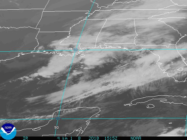
Frances is een beetje aan het inzakken, heeft last van vertical sheer winds uit het zuidwesten veroorzaakt door een kleine anticycloon aldaar.
De luchtdruk is van 936 mbar naar 957 mbar gestegen en het oog is verdwenen, zie ook hieronder:
te zien is dat "slechts" 100 kts gehaald word ipv 125 wat het was op het hoogtepunt, dus bijna terug naar categorie 2
[ Bericht 10% gewijzigd door meranto op 03-09-2004 17:57:31 ]
De luchtdruk is van 936 mbar naar 957 mbar gestegen en het oog is verdwenen, zie ook hieronder:


te zien is dat "slechts" 100 kts gehaald word ipv 125 wat het was op het hoogtepunt, dus bijna terug naar categorie 2
[ Bericht 10% gewijzigd door meranto op 03-09-2004 17:57:31 ]
Powered by Gentoo
Dan kon het wel eens snel afgelopen zijn.quote:Op vrijdag 3 september 2004 17:42 schreef meranto het volgende:
het oog is verdwenen
voor de liefhebber de laatste satelietfoto nog dan:
15:30 GMT
17:30 Rotterdamse tijd
Het blijft allemaal nog altijd maar een voorspelling, zo ging Charley in 3 uur tijd van 110 miles/h naar 145 miles/h en daalde de luchtdruk van 964 mbar naar 941 mbar voordat hij aan land ging.....
In 3 uur dus van categorie 2 naar 4, das best knap
[ Bericht 34% gewijzigd door meranto op 03-09-2004 18:01:30 ]
15:30 GMT
17:30 Rotterdamse tijd

Het blijft allemaal nog altijd maar een voorspelling, zo ging Charley in 3 uur tijd van 110 miles/h naar 145 miles/h en daalde de luchtdruk van 964 mbar naar 941 mbar voordat hij aan land ging.....
In 3 uur dus van categorie 2 naar 4, das best knap
[ Bericht 34% gewijzigd door meranto op 03-09-2004 18:01:30 ]
Powered by Gentoo
wat extra plaatjes (die ook elders op fok zijn gepost):
en de animatie hoe de orkaan zich uitbreid:
http://www.goes.noaa.gov/HURRLOOPS/huwvloop.html
[/quote]

en de animatie hoe de orkaan zich uitbreid:
http://www.goes.noaa.gov/HURRLOOPS/huwvloop.html
[/quote]
Drugs are good mkay?
Of een transformatie... als ze dan d'r oog weer open doet dan zal het goed raak zijnquote:Op vrijdag 3 september 2004 17:45 schreef Steijn het volgende:
[..]
Dan kon het wel eens snel afgelopen zijn.
die was gisteren toch al... nouja niet dat ik er veel van weet.. maar 2 keer een transformatie..quote:Op vrijdag 3 september 2004 20:16 schreef DemonRage het volgende:
[..]
Of een transformatie... als ze dan d'r oog weer open doet dan zal het goed raak zijn
Powered by Garmin Etrex Legend
Frances is wel een categorie 3 orkaan maar het gevaar van Frances nu is dat ze heel langzaam beweegt. Dat maakt kansen op overstromingen erg groot. Daarnaast zal Florida 2 dagen lang orkaan winden voelen door de trage beweging. Dus schade kan nog aanzienlijk zijn.
Frances is afgezwakt tot te 2e categorie: http://www.intellicast.co(...)rodnav=none&pid=none zie onderaan.
Huidige voorspelling:
Huidige voorspelling:

Powered by Gentoo
Compleet lege wegen (i-95) tussen Miami en Palm Beach door het uitstaande advies.
Omdat Frances nu zo goed als stilhangt ( 6km/h) voor de kust van Florida en waarschijnlijk deze snelheid zal aanhouden, kan Florida tussen de 10 en 20 uur overlast hebben van wind en hevige regenval, waarna velen zonder electriciteit zullen zitten.
En een schroefje van een camera dat de wind nu al niet kon weerstaan
Omdat Frances nu zo goed als stilhangt ( 6km/h) voor de kust van Florida en waarschijnlijk deze snelheid zal aanhouden, kan Florida tussen de 10 en 20 uur overlast hebben van wind en hevige regenval, waarna velen zonder electriciteit zullen zitten.


En een schroefje van een camera dat de wind nu al niet kon weerstaan


.quote:Op zondag 5 september 2004 00:51 schreef Steijn het volgende:
NBC6 Live
http://nbc6.feedroom.com/iframeset.jsp?ord=779815
Geweldig om al die mensen te zien die nu het strand op gaan .
Nou ik zou dolgraag zo'n hurricane meemaken. Noem me maar een fanaat maar wil ooit nog eens een hurricane of tyfoon meemaken. Dat wordt dus een keer een vakantie boeken in augustus. Natuurlijk is het erg gevaarlijk maar dat heb ik er wel voor over.quote:Op zondag 5 september 2004 01:07 schreef Roel_Jewel het volgende:
Geweldig om al die mensen te zien die nu het strand op gaan .
Aha.... Frances is behoorlijk bezig daar in florida. Windsnelheden tot 170km per uur, die hoop ik nooit meetemaken hier in nederland, volgens mij waait ons land dan compleet weg. Grootste oorkaan in 100jaar. paar miljoen mensen zonder stroom.
Frances is twee keer zo groot als Nederland . Dus als dat over ons land zou gaan, blijft er weinig staan, gok ik .quote:Op zondag 5 september 2004 10:54 schreef aloa het volgende:
Aha.... Frances is behoorlijk bezig daar in florida. Windsnelheden tot 170km per uur, die hoop ik nooit meetemaken hier in nederland, volgens mij waait ons land dan compleet weg. Grootste oorkaan in 100jaar. paar miljoen mensen zonder stroom.
Voor laatste nieuws over Frances is http://news.google.nl/ handig. Ook op http://edition.cnn.com/2004/WEATHER/09/05/hurricane.frances/ is wat info te vinden over schade en stroomuitval.
precies, dat moet maar niet. Ik kan me zulke windsnelheden niet voorstellen, als het hier echt stormt, kracht9 of meer, dan vind ik het al hard tekeer gaan.quote:Op zondag 5 september 2004 10:58 schreef Roel_Jewel het volgende:
[..]
Frances is twee keer zo groot als Nederland . Dus als dat over ons land zou gaan, blijft er weinig staan, gok ik .