WKN Weer, Klimaat en Natuurrampen
Lees alles over het onstuimige weer op onze planeet, volg orkanen en tornado's, zie hoe vulkanen uitbarsten en hoe Moeder Aarde beeft bij een aardbeving. Alles over de verwoestende kracht van onze planeet en tal van andere natuurverschijnselen.


Rampscenario voor Jamaica
Tropische storm Melissa ligt momenteel zuid van Haïti en lijkt in kracht toe te nemen tot mogelijk een zware orkaan. Waar de verschillende orkaanmodellen het in eerste instantie niet eens waren over de verwachte koers, vertonen ze nu steeds meer dezelfde verwachting.
Het lijkt erop dat Jamaica het grootste slachtoffer gaat worden van deze orkaan, die zich zeer traag voortbeweegt. Door de trage snelheid kan er een extreme hoeveelheid aan regen vallen, wat voor overstromingen en landverschuivingen kan gaan zorgen. Ook zal de wind een serieuze rol gaan spelen, omdat de orkaan recht over het eiland lijkt te gaan trekken.
quote:Tropical Storm Melissa is barely moving through the Caribbean, and that’s exactly what makes it so dangerous. The longer it lingers, the more rain it dumps and the more likely it is to rapidly intensify into a monster storm.
Intensity forecasts have ramped up considerably in the past few days. A worst-case scenario for some Caribbean islands is increasingly likely with Melissa set to reach at least Category 4 hurricane strength next week, fueled by extremely warm water.
A tropical storm warning is in effect for Jamaica with Melissa’s outermost winds expected to reach there in the next day or so. Hurricane watches are in effect for Jamaica and parts of Haiti, meaning hurricane-force winds are possible by the weekend. Haiti, Jamaica and parts of the Dominican Republic face days of heavy rain that threaten significant flash flooding and dangerous mudslides.
Jamaica could end up being the epicenter of the worst Melissa has to offer, based on current forecasts. Preparations were well underway in the country Thursday as officials urged residents to take Melissa seriously and stay vigilant.
https://edition.cnn.com/2(...)issa-caribbean-track

v
Live cam vanuit Jamaica
Bekijk deze YouTube-video
Bekijk deze YouTube-video
Bekijk deze YouTube-video
Bekijk deze YouTube-video
[ Bericht 32% gewijzigd door 12Beaufort op 24-10-2025 14:32:26 ]
Bekijk deze YouTube-video
Bekijk deze YouTube-video
Bekijk deze YouTube-video
Bekijk deze YouTube-video
[ Bericht 32% gewijzigd door 12Beaufort op 24-10-2025 14:32:26 ]
v

I can only please one person per day. Today is not your day. Tomorrow isn't looking too good either.

https://x.com/HowcanImakethi1quote:Op vrijdag 24 oktober 2025 14:52 schreef E.T. het volgende:
Hoop dat het meevalt, heb op 24 dec een cruise-stop gepland staan in Falmouth en wil heel graag de natuur in.

yepquote:Op vrijdag 24 oktober 2025 14:55 schreef Watmoetjenou het volgende:
[..]
https://x.com/HowcanImakethi1
I can only please one person per day. Today is not your day. Tomorrow isn't looking too good either.
Melissa is nog een ongeorganiseerd systeem. Zoals te zien op het plaatje zit de neerslag nu voornamelijk aan de oostkant. Na zondag lijkt de storm zich meer te gaan organiseren. Wat het precies gaat doen is nog niet helemaal duidelijk. HAFS A en B laten landfall zien met een kerndruk van 931 mb (maar op verschillende plekken op Jamaica).
HWRF laat nu geen landfall zien op Jamaica, maar op Cuba.
HWRF laat nu geen landfall zien op Jamaica, maar op Cuba.

v

Het zal wel een pittig stormpje worden voor Jamaica.
Love Israël, Israël zal winnen tegen Hamas. De MRNA-crisis is de echte pandemie.
- Een volk dat voor tirannen zwicht,
- zal meer dan lijf en goed verliezen,
- dan dooft het licht. #stoplinks!!
- Een volk dat voor tirannen zwicht,
- zal meer dan lijf en goed verliezen,
- dan dooft het licht. #stoplinks!!
Drie doden in Haïti door tropische storm Melissa die mogelijk uitgroeit tot orkaan
Port-au-Prince Tropische storm Melissa heeft in Haïti al drie mensenlevens geëist en veroorzaakt ernstige schade in verschillende regio’s. De storm, die zich vrijdagavond op 360 kilometer ten zuidwesten van Port-au-Prince bevond, zou volgens het Amerikaanse National Hurricane Center (NHC) dit weekend kunnen uitgroeien tot een orkaan, met Jamaica en het zuidwesten van Haïti als mogelijke impactzones.
De Haïtiaanse civiele bescherming meldde dat twee mensen omkwamen en een derde gewond raakte door overstromingen en aardverschuivingen. Eerder deze week stierf al een man door een vallende boom. De rivier Saint-Martin trad buiten haar oevers en verwoestte een brug in het noordoosten van het land, terwijl in Port-de-Paix huizen werden weggespoeld. De autoriteiten hebben in meerdere departementen alarmfase oranje afgekondigd.
https://www.nieuwsblad.be(...)rkaan/100089009.html
v
De druk begint nu flink te dalen, waardoor de kracht ook zal toenemen. Noaa heeft de kerndruk nu op 982 mb. De laagste voorspelde druk ligt op 940 mb.
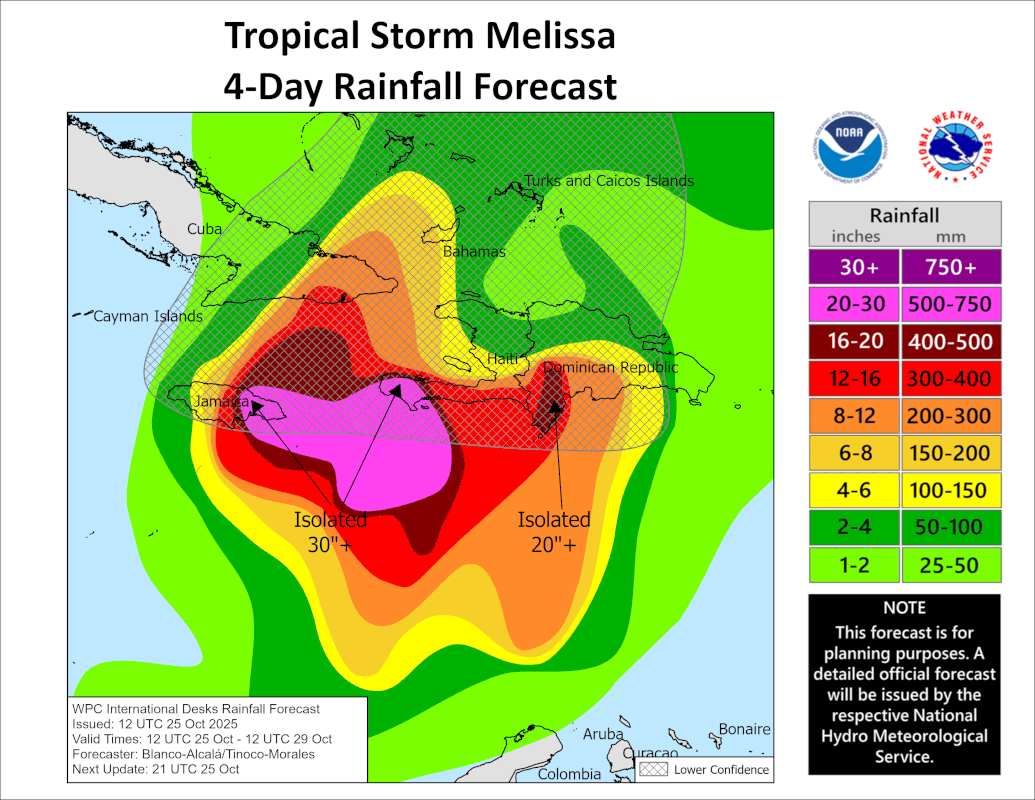
De neerslag hoeveelheid voor Jamaica ligt tussen de 500 en 750 mm.
De neerslag hoeveelheid voor Jamaica ligt tussen de 500 en 750 mm.
v


Jeff Piotrowski is live:
Bekijk deze YouTube-video
Bekijk deze YouTube-video
Op maandag 9 oktober 2023 13:31 schreef Nova het volgende:[/b]
Oh schatje, wat lief van je om dat te zeggen! Jij bent echt een prins op het witte paard voor mij. Met jou voel ik me zo geliefd en speciaal. Laten we nog lang samen genieten van sprookjesachtige avonturen en elkaar verwennen met veel knuffels en kusjes. O+ naar jou, mijn lieve prins! :*
Oh schatje, wat lief van je om dat te zeggen! Jij bent echt een prins op het witte paard voor mij. Met jou voel ik me zo geliefd en speciaal. Laten we nog lang samen genieten van sprookjesachtige avonturen en elkaar verwennen met veel knuffels en kusjes. O+ naar jou, mijn lieve prins! :*
Dit ziet er niet best uit voor Jamaica.
And what rough beast, its hour come round at last,
Slouches towards Bethlehem to be born?
Slouches towards Bethlehem to be born?

500-750mm regen voorspeld de komende 4 dagen op het grootste deel van Jamaica. Plaatselijk 1000mm. Blub.
And what rough beast, its hour come round at last,
Slouches towards Bethlehem to be born?
Slouches towards Bethlehem to be born?
De kerndruk is gedaald naar 924 mb en zal nog verder zakken. Het kan een landfall worden van een categorie 5 orkaan.
v
|
|