WKN Weer, Klimaat en Natuurrampen
Lees alles over het onstuimige weer op onze planeet, volg orkanen en tornado's, zie hoe vulkanen uitbarsten en hoe Moeder Aarde beeft bij een aardbeving. Alles over de verwoestende kracht van onze planeet en tal van andere natuurverschijnselen.


Winter op het zuidelijk halfrond 2025
Het is lente op het noordelijk halfrond, maar op het zuidelijk halfrond is het herfst. Het ijs van Antarctica is zich inmiddels weer aan het uitbreiden en hier en daar valt al de eerste sneeuw.
Ook hier kan de winter hard toeslaan, al is dat minder hard dan op het noordelijk halfrond. Het verschil zit vooral in de open zee die tussen Antarctica en het vaste land zit, hierdoor warmt de kou meer op omdat deze over nog 'warm' water zijn weg richting land zal moeten vinden. Vooral het zuidelijk deel van Argentinie, Chili en New Zeeland krijgen elk jaar te maken met winterweer, maar ook in het zuiden van Australie kan de winter van zich laten horen.
De weerrecords.
Opzich niet heel indrukkwekkend. Zelfs in Nederland is het kouder geweest dan in heel Oceanië.
-Zuid-Amerika: -39,0°C in Valle de Los Patos Superior, San Juan, Argentinië
-Oceanië: -25,6°C in Ranfurly, Nieuw-Zeeland
-De laagste temperatuur ooit in Australië gemeten was -23,0 graden op 28 juni 1994 in Charlotte Pass (New South Wales). Deze locatie in de Snowy Mountains ligt op 1727 meter hoogte en is doorgaans een koude plek. Ook in de zomer vriest het hier soms. Tasmanië noteerde op 30 juni 1983 minima van 13 graden onder nul. De temperatuur van het zeewater varieert zomers van 25 graden in Brisbane tot 15 graden in Tasmanië.
De bedoeling van dit topic is om het nieuws over de winter op het zuidelijk halfrond bij te houden.
Het topic van vorig jaar staat hier

Het is lente op het noordelijk halfrond, maar op het zuidelijk halfrond is het herfst. Het ijs van Antarctica is zich inmiddels weer aan het uitbreiden en hier en daar valt al de eerste sneeuw.
Ook hier kan de winter hard toeslaan, al is dat minder hard dan op het noordelijk halfrond. Het verschil zit vooral in de open zee die tussen Antarctica en het vaste land zit, hierdoor warmt de kou meer op omdat deze over nog 'warm' water zijn weg richting land zal moeten vinden. Vooral het zuidelijk deel van Argentinie, Chili en New Zeeland krijgen elk jaar te maken met winterweer, maar ook in het zuiden van Australie kan de winter van zich laten horen.

De weerrecords.
Opzich niet heel indrukkwekkend. Zelfs in Nederland is het kouder geweest dan in heel Oceanië.
-Zuid-Amerika: -39,0°C in Valle de Los Patos Superior, San Juan, Argentinië
-Oceanië: -25,6°C in Ranfurly, Nieuw-Zeeland
-De laagste temperatuur ooit in Australië gemeten was -23,0 graden op 28 juni 1994 in Charlotte Pass (New South Wales). Deze locatie in de Snowy Mountains ligt op 1727 meter hoogte en is doorgaans een koude plek. Ook in de zomer vriest het hier soms. Tasmanië noteerde op 30 juni 1983 minima van 13 graden onder nul. De temperatuur van het zeewater varieert zomers van 25 graden in Brisbane tot 15 graden in Tasmanië.

De bedoeling van dit topic is om het nieuws over de winter op het zuidelijk halfrond bij te houden.
Het topic van vorig jaar staat hier
v


Komende week gaat het flink sneeuwen in het gebergte van het zuidelijke eiland van New Zeeland (Nieuw-Zeelandse Alpen).
Op sommige plekken kan er meer dan 50 cm vallen. De sneeuw zal daarna weer snel verdwijnen door stijgende temperaturen.
[ Bericht 2% gewijzigd door 12Beaufort op 27-04-2025 16:14:48 ]
Op sommige plekken kan er meer dan 50 cm vallen. De sneeuw zal daarna weer snel verdwijnen door stijgende temperaturen.

[ Bericht 2% gewijzigd door 12Beaufort op 27-04-2025 16:14:48 ]
v
Nieuw Zeeland.
[ Bericht 0% gewijzigd door 12Beaufort op 28-04-2025 12:39:20 ]
quote:Unseasonal snow is expected for inland Canterbury on Wednesday and Thursday, MetService said, while wild winds were expected for eastern and central parts of the country from Wednesday, with disruptive southerlies expected to surge through Wellington.
"Everyone is going to get a bit of something this week – there will be some sun, lots of rain and strong winds, and even some snow coming our way, as a low-pressure system passes right over central Aotearoa New Zealand," MetService meteorologist Dom Barry said.
For the North Island, Barry said Northland, Auckland and Coromandel could expect wet and windy conditions from tomorrow, with heavy rain and thunderstorms expected for the northern most regions.
The South Island's West Coast will also see some heavy falls, while remaining areas of both islands have some cloud about, with the showers in the east.
Heavy rain would be hauled across much of the country heading into Wednesday by a low-pressure system set to track across the central North Island, Barry said.
Some of that rain would fall as snow above 600 metres in parts of the South Island.
https://www.odt.co.nz/new(...)eather-ahead-most-nz
[ Bericht 0% gewijzigd door 12Beaufort op 28-04-2025 12:39:20 ]
v
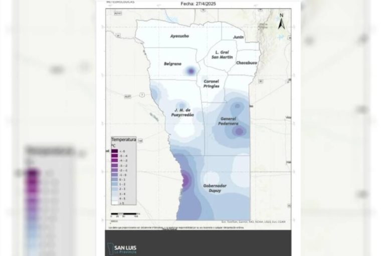
In San Luis (Argentinië) is de temperatuur dit jaar voor het eerst onder het vriespunt gedaald. In de departementen Dupuy en Belgrano werden bijzonder lage temperaturen geregistreerd. Daarnaast viel er tot zondagmorgen regen in een groot deel van het binnenland van de provincie.
Volgens de kaart van het REM zijn in verschillende delen van de provincie voor het eerst dit jaar temperaturen onder nul gemeten. In het zuiden van de provincie, nabij de grens met Mendoza en in het departement Belgrano, werden temperaturen tussen -1 en -2 graden geregistreerd.
Volgens de kaart van het REM zijn in verschillende delen van de provincie voor het eerst dit jaar temperaturen onder nul gemeten. In het zuiden van de provincie, nabij de grens met Mendoza en in het departement Belgrano, werden temperaturen tussen -1 en -2 graden geregistreerd.
v
Code geel, in Nieuw Zeeland voor woensdag en donderdag. Er kan tot een hoogte van 800 meter sneeuw gaan vallen.

v
Winters weer op het zuidelijk eiland van Nieuw Zeeland. Er is een code oranje voor sneeuw tot 800 meter hoogte in de Nieuw Zeelandse Alpen. Ook staat er storm met windstoten tot 130 km.

quote:Orange heavy snow warnings were in force overnight for the Canterbury High Country, with 12 to 20cm of snow expected to fall above 800 metres.
Several watches were in place, including heavy rain watches for the eastern Bay of Plenty, Wairarapa and Wellington.
Strong wind watches were also forecast for Auckland, the Coromandel Peninsula, northern Waikato, inland Wairarapa, southern Hawke's Bay, Horowhenua and Kapiti Coast, the Marlborough Sounds, and the West Coast.
https://www.1news.co.nz/2(...)rong-winds-for-wgtn/
v
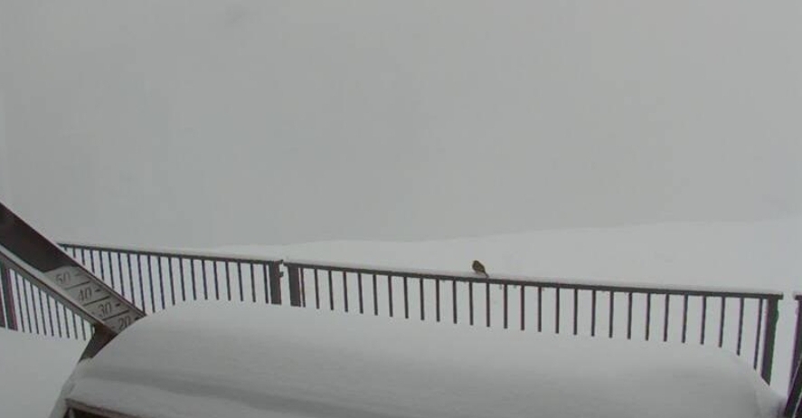
Een aantal webcams vanuit Nieuw Zeeland. Afgelopen nacht is daat sneeuw gevallen.
Verder in Nieuw Zeeland veel overlast door overstromingen. Onder de 800 meter is de sneeuw als regen gevallen en heeft daar enkele rivieren doen overstromen.


Verder in Nieuw Zeeland veel overlast door overstromingen. Onder de 800 meter is de sneeuw als regen gevallen en heeft daar enkele rivieren doen overstromen.
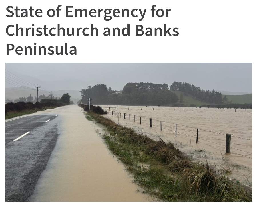
quote:A Local State of Emergency has been declared for Christchurch and Banks Peninsula.
Mayor Phil Mauger made the declaration at 4pm due to the impact of the wet weather such as flooding, slips, landslide and falling trees, particularly on Banks Peninsula.
“We need to make sure we’re able to keep people safe by putting all of our resources into responding to any problems that arise and one of the best ways we can do this is by declaring a Local State of Emergency.”
“We expected the weather would ease, which hasn’t happened so declaring will mean we are prepared for anything that may happen overnight,” the Mayor said.
“The decision to include Christchurch was made as precautionary measure. High tide is expected at 7.41pm so declaring means we would have access to powers under the State of Emergency if they’re required.”
https://www.newsline.ccc.(...)-and-banks-peninsula
v
In het zuidelijk deel van Argentinië gaat de temperatuur naar winterse waarden. Op een aantal plekken is zelfs strenge vorst mogelijk.
Ook neemt de kans op sneeuw toe de komende dagen.
Ook neemt de kans op sneeuw toe de komende dagen.
quote:Er wordt zware sneeuwval verwacht in Bariloche
Op zaterdag zal de minimumtemperatuur 1º zijn en slechts oplopen tot 3º. Er worden zware sneeuwbuien verwacht die de hele dag aanwezig zullen zijn. De wind zal 50 kilometer per uur bereiken met rukwinden van 78 kilometer per uur.
Voor zondag wordt een minimumtemperatuur van -2º en een maximum van 4º verwacht. Er is 40 procent kans op sneeuwbuien in de ochtend en in de middag, afgewisseld met regen. De wind van 31 kilometer per uur kan rukwinden van 50 kilometer per uur bereiken.
https://www.elcordilleran(...)ertes-para-bariloche

v
Er geldt een code oranje voor sneeuw en wind in het berggebied. Er worden slechte weersomstandigheden verwacht met veel regenval en harde wind. De getroffen gebieden zijn:
Aluminé-gebergte.
Het Chos Malal-gebergte.
Loncopué-gebergte.
Minas-gebergte.
Picunches-gebergte.
Ñorquín-gebergte.
Huiliches-gebergte.
Het Lácargebergte.
Ten zuiden van Aluminé.
In Río Negro gelden de volgende gebieden met een waarschuwing voor sneeuw en wind:
Bariloche.
Pilcaniyeu-gebergte.
Ñorquincó-gebergte.
https://www.rionegro.com.(...)n-de-semana-4129550/
v
Zware regenval heeft zaterdag in de Argentijnse provincie Buenos Aires tot overstromingen geleid. Duizenden mensen zijn geëvacueerd, maar er zijn voorlopig geen meldingen van slachtoffers.
Op verschillende plaatsen in de provincie zijn rivieren en beken buiten hun oevers getreden. Belangrijke verkeersassen zijn ondergelopen en heel wat akkers staan onder water. Gouverneur Axel Kicillof zegt dat de toestand vooral in de overstroomde landbouwgebieden kritiek is. Daarnaast staan ook in Campana en Zarate, twee steden ten noorden van de hoofdstad Buenos Aires, meerdere straten blank.
Minstens 3.700 mensen in het noorden van de provincie zijn geëvacueerd, zo meldt de krant La Nación op basis van de nationale hulpdiensten. Op tv-beelden is te zien hoe mensen met bootjes uit hun huizen worden gehaald.
Volgens de nieuwssite Infobae zijn ook drie autobussen met tientallen kinderen, die terugkeerden van een schoolreis in de stad Buenos Aires, gestrand op een landweg. “Ze zitten al twaalf uur vast”, zo getuigt de moeder van een van de getroffen 12-jarige meisjes.
https://m.nieuwsblad.be/c(...)ll&utm_source=google
v
Een witte wereld voor het meest zuidelijke stadje ter wereld.


Bekijk deze YouTube-videoquote:Ushuaia is de zuidelijkste stad ter wereld. Het is gelegen aan de zuidelijke kust van de provincie Vuurland, Antarctica en Zuid-Atlantische eilanden van Argentinië, aan het Beaglekanaal. Het is de hoofdstad van die provincie en telt ongeveer 60.000 inwoners.
https://nl.wikipedia.org/wiki/Ushuaia
v

quote:Fears for an extreme cold snap have not eventuated, despite chilly temperatures around the motu.
The country went into the latter part of the week with almost two dozen weather warnings in place, but rain eased on Friday in Tāupo and the Bay of Plenty, and the South avoided heavy snowfall.
On Saturday, a strong wind watch was issued for the Chatham Islands through to Sunday due to a nearby deep low, bringing northerly gales.
MetService meterologist Sylvia Martino told RNZ Dunedin Airport and Takapō took out the chilliest spots, at minus five overnight, while Christchurch dropped to minus one.
Snow has closed parts of State Highway 85 in Otago, State Highway 80 between Lake Pukaki and Aoraki/Mount Cook and State Highway 8 between Fairlie and Twizel.
MetService had issued an orange-level heavy snow warning for inland Canterbury, from the Rakaia River southwards, overnight. A heavy snow watch remained for inland areas of Canterbury and Marlborough between the Rakaia River and Ward until later on Saturday morning.
A warning was also in place for State Highway 1 on the central North Island's Desert Road, with one to three centimetres of snow to accumulate above 800 metres.
https://www.rnz.co.nz/new(...)-chilly-temperatures
v
quote:MetService says it's time to start "digging out those thermals" as a cold front is bringing plunging temperatures to many across the country from today.
Disruptions have already begun with "very rough" sea conditions forcing the cancellation of Cook Strait ferry sailings this weekend.
MetService meteorologist Heather Keats told Breakfast the cold was going to be "quite a shock to the system".
"So we've got this south-easterly flow that's going to turn southerly. That's going to spread all over the country today [and] tomorrow, it won't really start to ease until Sunday," she said.
"When you've got the source here being from the south, it's going to be cold and then when you have a massive low which we do hanging out east, that's going to be the driving force of the rain front today, which is going to push onto the South Island."

https://www.1news.co.nz/2(...)ecasts-cold-weekend/
v
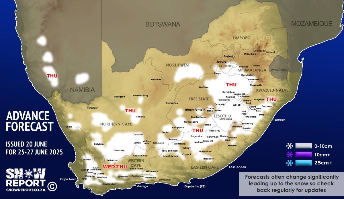
quote:Niet alleen Zuid-Afrika en Lesotho, maar ook delen van Namibië en Botswana zijn in de greep van winterse kou. Sinds dit weekend en begin volgende week grijpt een koudebel uit de Zuidelijke Oceaan om zich heen. Sneeuw in Zuid-Afrika zal vallen in minstens 8 van de 9 provincies. Waarschuwingen en code geel voor zware sneeuw zijn uitgevaardigd, vooral in de hoger gelegen plateaus en bergen, en in Lesotho.
In acht van de negen provincies gaat het sneeuwen, wat vrij uitzonderlijk weer in Zuid-Afrika is. Toch is sneeuw op de hoogste tafelbergen (bij Kaapstad, en in de Drakensbergen) niet ongewoon. Maar nu valt er wel degelijk veel sneeuw. Enkel de Limpopo-provincie (in het noordoosten) blijft buiten schot.
Zware sneeuwval in Lesotho, tot 60 cm sneeuw
Verder wordt op maandag zware sneeuwval verwacht in Lesotho (tot 60 cm) en de grensregio’s van de Vrijstaat, KwaZoeloe-Natal en de zuidelijke Drakensbergen. In KwaZoeloe-Natal, met name in het westen en rond het plaatsje Underberg (aan de voet van voorgenoemde bergen), zal het op maandag zwaar sneeuwen bij extreem lage temperaturen. Ook in delen van de Vrijstaat-provincie, met name het oosten, kan een lichte sneeuwlaag vallen. Meer zware sneeuw wordt verwacht rond de Sanipas (route tussen Lesotho en Zuid-Afrika) en omliggende bergen.
https://www.noodweer.be/s(...)rctische-kou-080625/
v


Van bijna dood tot olympiër:
Bwoah wat een genot daar
Van bijna dood op weg naar de Olympische Spelen, tot olympiër in 2026? Elk beetje hulp wordt bijzonder gewaardeerd!
https://www.gofundme.com/(...)he-spelen-na-ongeval
https://www.gofundme.com/(...)he-spelen-na-ongeval
Dodentol door sneeuwstormen in Zuid-Afrika loopt op tot 49, ook acht schoolkinderen overleden nadat bus wordt weggespoeld
De dodentol door de overstromingen na de sneeuwstormen in Zuid-Afrika van de voorbije dagen is opgelopen tot 49, onder wie vier kinderen in een schoolbus. Dat hebben de autoriteiten van de provincie Oost-Kaap woensdag gemeld op basis van informatie van de politie. De weerdienst waarschuwt voor nog meer overstromingen en landverschuivingen.
Vooral de provincies Oostkaap en KwaZulu-Natal zijn hard getroffen. Verschillende wegen rond de stad Kokstad zijn afgesloten. De Zuid-Afrikaanse weerdienst heeft voor verschillende gemeenten in de provincie Oostkaap het op één na hoogste waarschuwingsniveau voor sneeuwval afgekondigd.
Nabij de stad Mthatha, in de Oost-Kaap, werd een schoolbus meegesleurd door het wassende water. Zeker acht kinderen en de chauffeur kwamen om het leven, meldt de politie woensdag. Drie kinderen konden zich redden.
https://www.hln.be/weerni(...)%2Fwww.google.com%2F
v

quote:Op donderdag 12 juni 2025 06:28 schreef 12Beaufort het volgende:
Dodentol door sneeuwstormen in Zuid-Afrika loopt op tot 49, ook acht schoolkinderen overleden nadat bus wordt weggespoeld
De dodentol door de overstromingen na de sneeuwstormen in Zuid-Afrika van de voorbije dagen is opgelopen tot 49, onder wie vier kinderen in een schoolbus. Dat hebben de autoriteiten van de provincie Oost-Kaap woensdag gemeld op basis van informatie van de politie. De weerdienst waarschuwt voor nog meer overstromingen en landverschuivingen.
Vooral de provincies Oostkaap en KwaZulu-Natal zijn hard getroffen. Verschillende wegen rond de stad Kokstad zijn afgesloten. De Zuid-Afrikaanse weerdienst heeft voor verschillende gemeenten in de provincie Oostkaap het op één na hoogste waarschuwingsniveau voor sneeuwval afgekondigd.
Nabij de stad Mthatha, in de Oost-Kaap, werd een schoolbus meegesleurd door het wassende water. Zeker acht kinderen en de chauffeur kwamen om het leven, meldt de politie woensdag. Drie kinderen konden zich redden.
https://www.hln.be/weerni(...)%2Fwww.google.com%2F
|
|