WKN Weer, Klimaat en Natuurrampen
Lees alles over het onstuimige weer op onze planeet, volg orkanen en tornado's, zie hoe vulkanen uitbarsten en hoe Moeder Aarde beeft bij een aardbeving. Alles over de verwoestende kracht van onze planeet en tal van andere natuurverschijnselen.


Vooralsnog alleen absoluut pleurisweer, tot aan PDS thunderstorm warnings aan toe
100.000 katjes
Fuck the EBU!
Fuck the EBU!
Ook zeer veel regen verwacht in een groot gebied
Wir werden vermutlich einiges bezüglich Überschwemmungen aus den USA hören bis zum Wochenende. Der Streifen mit 100 bis lokal > 300 l/m² hat eine SW - NO Ausdehnung von über 1500 Kilometer. Alle Modelle zum Vergleich
https://x.com/Kachelmannwettr/status/1907153623215128990
Wir werden vermutlich einiges bezüglich Überschwemmungen aus den USA hören bis zum Wochenende. Der Streifen mit 100 bis lokal > 300 l/m² hat eine SW - NO Ausdehnung von über 1500 Kilometer. Alle Modelle zum Vergleich
https://x.com/Kachelmannwettr/status/1907153623215128990
Never Stop Exploring!
Life begins at the end of your comfort zone!
Follow me on Twitter: https://twitter.com/EdwinKr83 Instagram: https://www.instagram.com/edwinkr83/
Life begins at the end of your comfort zone!
Follow me on Twitter: https://twitter.com/EdwinKr83 Instagram: https://www.instagram.com/edwinkr83/
High risk idd met name voor regen.quote:Op dinsdag 1 april 2025 21:51 schreef INViCTuS het volgende:
Ook zeer veel regen verwacht in een groot gebied
Wir werden vermutlich einiges bezüglich Überschwemmungen aus den USA hören bis zum Wochenende. Der Streifen mit 100 bis lokal > 300 l/m² hat eine SW - NO Ausdehnung von über 1500 Kilometer. Alle Modelle zum Vergleich
https://x.com/Kachelmannwettr/status/1907153623215128990

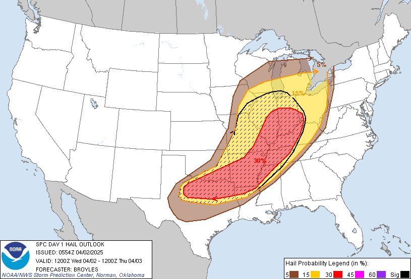

Is dit ook alleen voor neerslag of nu ook voor tornado's?quote:
[ afbeelding ]
Nog iets uitgebreid vanochtend.
edit: tornado's dus ook
quote:...SUMMARY...
A tornado outbreak is expected today and tonight from parts of the
mid Mississippi and lower Ohio Valleys westward into the eastern
Ozarks. Numerous tornadoes, along with multiple long-track EF3+
tornadoes appear likely. In addition, tornadoes, severe wind gusts,
and large hail will be possible across a broad area from north Texas
northeastward to the southern Great Lakes.
...Mid Mississippi and Lower Ohio Valleys/Eastern Ozarks...
A potent mid-level trough will move northeastward across the central
U.S. today, as a mid-level jet strengthens to over 120 knots, and
ejects rapidly northeastward into the Upper Midwest. At the surface,
a low will move into the upper Mississippi Valley, as a cold front
advances eastward through the central states. Ahead of the front, a
moist airmass will advect northward into the Ozarks and lower to mid
Mississippi Valley, with surface dewpoints increasing into the mid
to upper 60s F. While storms will likely be ongoing near the front
during the day, the airmass further to the east is forecast to
remain undisturbed and will significantly destabilize during the
day. By early to mid afternoon, MLCAPE is forecast to increase into
the 2500 to 3500 J/kg range across much of the moist airmass. The
500 mb jet is forecast to eject northeastward at nearly 55 knots
into the upper Mississippi Valley. Large-scale ascent associated
with the right entrance region of the jet will overspread the moist
sector, becoming favorable for vigorous convective development.
Model forecasts are in relatively good agreement, that scattered
discrete convective initiation will take place well to the east of
the front near the instability axis during the mid to late
afternoon. Forecast soundings across the mid Mississippi Valley from
21Z to 00Z increase 0-3 km storm-relatively helicity to around 400
m2/s2, and have strong deep-layer shear near 60 knots. This will be
favorable for supercells and tornadoes. The ECMWF and NAM are in
good agreement, developing a 60 to 70 knot low-level jet max
centered over far western Tennessee at 00Z. As supercells move
eastward into the low-level jet, very strong low-level shear will be
favorable for numerous tornadoes. The most intense tornadic
supercells will be capable of producing long-track EF3+ tornadoes.
Multiple EF3+ tornadoes are expected in the mid Mississippi Valley.
The duration of the tornado threat should persist from afternoon
into the evening. A potential for supercells and tornadoes will
extend northward into the lower Ohio Valley and southwestward into
the southern Ozarks. In those two locations, the more intense
discrete supercells could produce strong tornadoes.
In addition to the tornado threat, supercells associated with large
hail and severe wind gusts are expected to form in the mid to late
afternoon across a large area from the Ark-La-Tex northeastward to
the southern Great Lakes. Large hail will also be possible with
supercells that develop along and near the front, further west into
the Ozarks. The more intense supercells should have potential to
produce hailstones greater than 2 inches in diameter. During the mid
to late evening and overnight period, several organized line
segments are expected to organize and move eastward into the
Tennessee Valley, lower Ohio Valley and southern Great Lakes. Gusts
above 70 mph will be possible with the more intense bowing segments.
The severe threat is expected to continue into the overnight period.
...North Texas...
A mid-level trough will move northeastward across the central Plains
this morning. At the surface, as a cold front will advance eastward
through the southern Plains. Ahead of the front, a moist and
unstable airmass will be in place over much of the eastern half of
Texas. In spite of weak forcing, isolated thunderstorms may initiate
along or ahead of the front as surface temperatures warm this
morning. Forecast soundings ahead of the front in north Texas have
0-6 km shear around 50 knots with 700-500 mb lapse rates near 7.5
C/km. This environment will likely support a large hail threat with
any supercells that can develop. Hailstones greater than 2 inches in
diameter and severe wind gusts will be possible within the more
vigorous supercell downdrafts. The severe threat is expected to
gradually end during the day across parts of northwest and
north-central Texas as the front moves eastward. However, isolated
supercells with large hail could redevelop during the evening and
overnight, as warm advection again brings low-level moisture
northward into the Red River Valley.
Blijft ook donderdag, vrijdag en zaterdag onrustig waarbij het grootste gevaar op woensdag en zaterdag ligt


wel vaak raak de laatste tijd. 2e high risk al
Never Stop Exploring!
Life begins at the end of your comfort zone!
Follow me on Twitter: https://twitter.com/EdwinKr83 Instagram: https://www.instagram.com/edwinkr83/
Life begins at the end of your comfort zone!
Follow me on Twitter: https://twitter.com/EdwinKr83 Instagram: https://www.instagram.com/edwinkr83/
Van bijna dood tot olympiër:

Van bijna dood op weg naar de Olympische Spelen, tot olympiër in 2026? Elk beetje hulp wordt bijzonder gewaardeerd!
https://www.gofundme.com/(...)he-spelen-na-ongeval
https://www.gofundme.com/(...)he-spelen-na-ongeval
Van bijna dood tot olympiër:
Een Y'All Watch 
Van bijna dood op weg naar de Olympische Spelen, tot olympiër in 2026? Elk beetje hulp wordt bijzonder gewaardeerd!
https://www.gofundme.com/(...)he-spelen-na-ongeval
https://www.gofundme.com/(...)he-spelen-na-ongeval
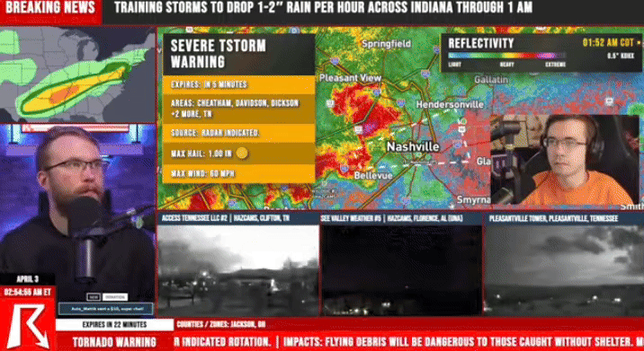
Selmer TN is al geraakt door een tornado maar die bovenstaande links van Hornsby gaat er nog een keer overheen als ze pech hebben 


quote:
Edit: Minimaal één van die foto's is nep, want daglicht. Eerste comment onder die Tweet haalt dat ook al aan. Triest.
100.000 katjes
Fuck the EBU!
Fuck the EBU!
|
|