WKN Weer, Klimaat en Natuurrampen
Lees alles over het onstuimige weer op onze planeet, volg orkanen en tornado's, zie hoe vulkanen uitbarsten en hoe Moeder Aarde beeft bij een aardbeving. Alles over de verwoestende kracht van onze planeet en tal van andere natuurverschijnselen.


Inmiddels schijnt dat al op 32 te liggenquote:Op zaterdag 15 maart 2025 22:41 schreef 12Beaufort het volgende:
20 doden..
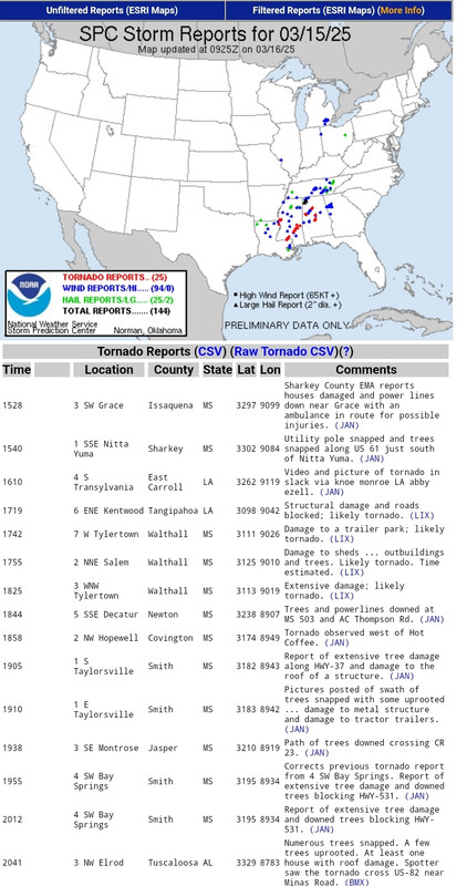
The threat of tornadoes in parts of the U.S. proved deadly as whipping winds moved east into the Mississippi Valley and Deep South on Saturday, causing at least 20 fatalities in four states, injuries and widespread damage.
Mississippi Gov. Tate Reeves said on social media Saturday that tornadoes had been reported in six counties overnight. He said three hospitalizations have been reported and that "this number is expected to increase." More severe weather is expected in the state today, he said.
Never Stop Exploring!
Life begins at the end of your comfort zone!
Follow me on Twitter: https://twitter.com/EdwinKr83 Instagram: https://www.instagram.com/edwinkr83/
Life begins at the end of your comfort zone!
Follow me on Twitter: https://twitter.com/EdwinKr83 Instagram: https://www.instagram.com/edwinkr83/
Wat 'n beelden, ook die post hiervoor. Die boomsprietjesquote:Op zondag 16 maart 2025 07:09 schreef Drass het volgende:
https://youtube.com/shorts/ciVkpkvt_gA?si=aflHJnmAWZOWLWp1
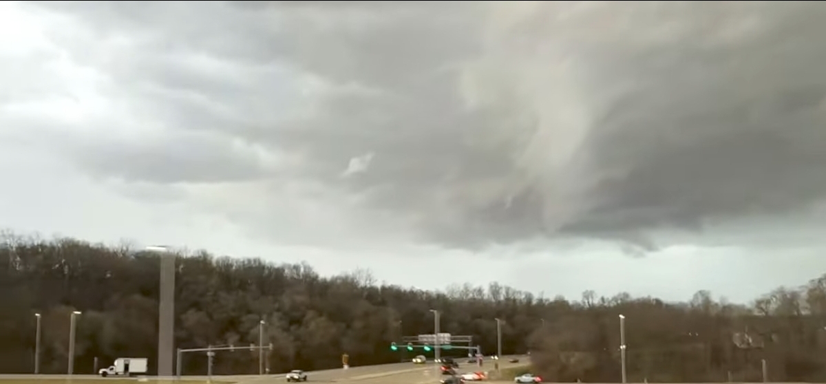
Cave City in Arkansas

Violent tornadoes ripped through parts of the U.S., wiping out schools and toppling semitractor-trailers, part of a monster storm that has killed at least 36 people across six states.
The deaths came as a massive storm system moving across the country unleashed winds that triggered deadly dust storms and fanned more than 100 wildfires. Forecasters assigned an unusual "high risk" designation to the system, which was also blamed for icy winter weather in northern parts of the country and severe thunderstorms, including on the West Coast, on Sunday.
In all, extreme weather conditions were forecast to affect an area home to more than 100 million people. Winds gusting up to 80 mph were predicted from the Canadian border to Texas, threatening blizzard conditions in colder northern areas and wildfire risk in warmer, drier places to the south.
Heavy thunderstorms in the forecast for Ponte Vedra Beach, Florida, prompted schedule changes for the 2025 Players Championship, CBS Sports reported. The tournament moved up tee times Sunday and grouped golfers together to ensure the last 18 holes would be completed before the evening.
https://news.google.com/r(...)S&gl=US&ceid=US%3Aen
v
Je moet ook wel echt een totaalidioot zijn als je deze beelden kan maken.quote:
100.000 katjes
Fuck the EBU!
Fuck the EBU!
Die zijn er gelukkig genoeg, dus ik speur twitter wel even af :pquote:
[..]
Je moet ook wel echt een totaalidioot zijn als je deze beelden kan maken.
quote:Al minstens veertig doden door stormen en tornado's in Verenigde Staten
Het aantal doden door de zware stormen die sinds vrijdag door het midden en zuiden van de Verenigde Staten trekken, is opgelopen tot minstens veertig. De stormen gaan gepaard met tornado's en bosbranden.
De staat Missouri is met zeker twaalf doden het zwaarst getroffen, melden CNN en BBC News. Gouverneur Mike Kehoe spreekt van "verbijsterende verwoesting". Hij meldt dat honderden huizen, scholen en bedrijven verloren zijn gegaan of zwaar zijn beschadigd.
In Kansas kwamen ten minste acht mensen om het leven nadat een zandstorm een kettingbotsing met 55 voertuigen had veroorzaakt. Texas werd getroffen door een soortgelijke storm. Daarbij botsten 38 auto's op elkaar en kwamen minstens vier mensen om het leven.
In Oklahoma woedden bijna 150 bosbranden, aangewakkerd door windstoten tot 133 kilometer per uur. Hierbij zijn inmiddels vier doden gemeld.
Ook Mississippi werd zwaar getroffen, met zes dodelijke slachtoffers door tornado's. In Arkansas kwamen drie mensen om en raakten 29 anderen gewond. Alabama telde nog eens drie doden, onder wie een 82-jarige vrouw.
Noodtoestand uitgeroepen in Arkansas, Georgia en Oklahoma
In Arkansas, Georgia en Oklahoma is de noodtoestand uitgeroepen. "De Nationale Garde is ingezet in Arkansas en mijn regering staat klaar om de staats- en lokale functionarissen te helpen, terwijl ze hun gemeenschappen helpen te herstellen van de schade", schrijft president Donald Trump op zijn eigen platform Truth Social.
Het stormvoorspellingscentrum van de nationale weerdienst meldt dat de stormen richting de oostkust van de VS trekken. Tegen maandagavond en dinsdag zou het aan de hele oostkust opgeklaard moeten zijn.
Voor diegenen die nog weten wat de term *Joplin* in dit topic betekent
Nu op netflix
https://www.moviemeter.nl(...)oed-op-netflix-17075
Bekijk deze YouTube-video
Nu op netflix
https://www.moviemeter.nl(...)oed-op-netflix-17075
Bekijk deze YouTube-video
Echt wel 1 van de meest extreme tornado's die er zijn geweest. Omvang, schade en leed. 1.6 km breed met windsnelheden 300/320 km/h. dat is echt bizar.quote:Op zaterdag 22 maart 2025 10:06 schreef Frutsel het volgende:
Voor diegenen die nog weten wat de term *Joplin* in dit topic betekent
Nu op netflix
https://www.moviemeter.nl(...)oed-op-netflix-17075
Bekijk deze YouTube-video
Ik ga dit nog wel kijken
Never Stop Exploring!
Life begins at the end of your comfort zone!
Follow me on Twitter: https://twitter.com/EdwinKr83 Instagram: https://www.instagram.com/edwinkr83/
Life begins at the end of your comfort zone!
Follow me on Twitter: https://twitter.com/EdwinKr83 Instagram: https://www.instagram.com/edwinkr83/
Doet mij ook weer terugdenken aan de El Reno tornado met daarbij een aantal stormjagers van Discovery die overleden.
Deze en die van Joplin via Fok kunnen volgen. Behoorlijk heftig.
Deze en die van Joplin via Fok kunnen volgen. Behoorlijk heftig.
Ik zag hem gisteren voorbij komen.quote:
Voor diegenen die nog weten wat de term *Joplin* in dit topic betekent
Nu op netflix
https://www.moviemeter.nl(...)oed-op-netflix-17075
Bekijk deze YouTube-video
Ga ik zeker eerdaags kijken...
Een paar jaar daar voor had je die van Greensburg. Die vond ik net zo extreem...
v

Ik heb hem woensdag gelijk gekeken maar vond het wel jammer dat er best diep in gegaan wordt op de personen die vertellen. Ik wil gewoon vooral de spannende tornadobeelden zien en dat vond ik in verhouding te weinig. Desalniettemin altijd goed als er een natuurrampenserie/docu/film bij komt, zo vaak maken ze die niet!quote:
Voor diegenen die nog weten wat de term *Joplin* in dit topic betekent
Nu op netflix
https://www.moviemeter.nl(...)oed-op-netflix-17075
Bekijk deze YouTube-video
Er zijn tekenen dat komend weekend een flinke uitbraak kan opleveren. Ditmaal niet de mazzel dat alle energie 2 dagen eerder door een kleiner voorgerecht wordt weggenomen.
100.000 katjes
Fuck the EBU!
Fuck the EBU!
The primary severe risk appears likely to evolve Sunday/Day 6, from
Missouri/Arkansas/northern Louisiana, spreading eastward through the
day, and eventually approaching the west slopes of the Appalachians.
As the western U.S. upper trough emerges into the Plains,
supporting deepening of surface low pressure, a moist warm sector
will destabilize through the day, likely yielding storm development
initially west of the Mississippi Valley, and then spreading
eastward through the evening. The favorable thermodynamic
environment will combine with strong/veering flow through the middle
troposphere, suggesting of severe storms including supercells, and
attendant, all-hazards severe potential.
Vooralsnog geen grote zorgen, maar borrelt wel wat.


Joekel van een gebied inmiddels opgewaardeerd

quote:...SUMMARY...
A widespread/substantial severe-weather episode is forecast across
an area centered on the Ohio/Mid and Lower Mississippi/Lower
Missouri/Tennessee River Valleys. Very large hail, damaging winds,
and strong tornadoes are expected.
...Synopsis...
An evolving/slowly amplifying mid-level trough is forecast to shift
slowly across the central U.S. Sunday. As this occurs, a deepening
surface low will shift northeastward across the Upper Great Lakes
region. A trailing cold front will sweep southeastward across the
central U.S. as the low deepens/advances, and should extend from the
Lower Great Lakes to the central Gulf Coast states by Monday
morning.
...Lower Great Lakes to the Lower Mississippi and Tennessee
Valleys...
A broad/moist but initially capped airmass is forecast to expand
across much of the eastern half of the U.S. Sunday, ahead of the
advancing cold front. Daytime heating, and continued northward flux
of low-level moisture will result in a moderate destabilization.
Scattered storms may be ongoing across portions of Missouri
northeastward to the Wisconsin area at the start of the period, and
possibly in a more isolated manner southwestward into Texas. Local
severe risk may accompany this early-day convection. The
aforementioned destabilization that is expected should support
renewed storm development near the advancing cold front -- initially
from Illinois southwestward to East Texas, and then spreading
eastward/expanding in coverage with time.
Along with the favorable thermodynamic environment within which the
storms will be evolving, highly favorable shear will also exist,
with low-level southerly/southwesterly flow veering and increasing
substantially with height yielding curved -- and then elongated --
hodographs. Supercells are expected within this environment, and
very large hail is expected given the cold air/steep lapse rates
through the mid troposphere. Along with the hail risk, damaging
wind gusts are expected -- particularly where upscale growth into
bands occurs. Additionally, this setup appears very favorable for
tornadoes, a few of which may be strong/potentially long-lived.
Risk will spread eastward with time into the evening/overnight.
Some diminishing of the risk should occur late into the upper Ohio
Valley, but vigorous storms and all-hazards risk will likely
continue through the end of the period across the Tennessee
Valley/Gulf Coast states.
|
|