WKN Weer, Klimaat en Natuurrampen
Lees alles over het onstuimige weer op onze planeet, volg orkanen en tornado's, zie hoe vulkanen uitbarsten en hoe Moeder Aarde beeft bij een aardbeving. Alles over de verwoestende kracht van onze planeet en tal van andere natuurverschijnselen.


De Verenigde Staten kennen extreme weersituaties. Tornado's en orkanen eisen elk jaar tientallen levens. Plotseling opkomende onweersbuien zijn vooral in Florida gevaarlijk. In bergachtige gebieden en in woestijnen neemt de grond weinig water op en veranderen beekjes als gevolg van hevige regenval plotseling in kolkende watermassa's.
Ook in Europa en in Nederland komen tornado's voor. Voor Europa hebben we inmiddels dit topic:
WKN / Tornado's in Europa #1
Tornado's
Tornado's ontstaan overal in de Verenigde Staten, maar het merendeel ten oosten van de Rocky Mountains in Texas, Kansas en Oklahoma, ook wel Tornado Alley genoemd. Jaarlijks razen ongeveer 1000 tornado's over de Verenigde Staten.
Er zijn twee tornadoseizoenen. De eerste is in april en mei en het tweede in november. In november beperken de tornado's zich meer tot Alabama, Kentucky, Mississippi en Louisiana.
Maar jaarlijks komen er in bijna alle staten tornado's voor.
Florida is berucht wegens het grote aantal onweersdagen. In Lightning Alley onweert het op meer dan 90 dagen per jaar.
Tornado's vs Orkanen
Tornado's worden vaak verward met Orkanen. Terwijl tornado's lokaal veel schade aan kunnen richten hebben we het bij tornado's over een klein gebied (enkele kilometers in doorsnee) waarbij de zware tornado's windsnelheden van 400-500km/u kunnen halen en daar totale verwoesting aanrichten. Vaak duurt een tornado hooguit enkele minuten of incidenteel tientallen minuten.
zie ook: Tornado information - Wiki en Tornado Fujita Scale
Als je wilt weten wat de schade kan zijn bij verschillende tornado's kijk je even hier waar in foto's wordt afgebeeld wat de schade is.
https://watchers.news/201(...)age-scale-in-images/

Orkanen daarentegen zijn enorme (onweers-/noodweer) complexen die honderden kilometers qua omtrek kunnen zijn waarbij de zwaarste orkanen windsnelheden van 250-300+ km/u worden gehaald en er een vloedgolf aan water mee komt die meters hoog het land op wordt gestuwd. Tevens kunnen deze complexen wel een dag aanhouden en daarbij enorme hoeveelheden neerslag laten neerdalen op een enorm groot gebied.
Meer informatie over de orkanen vindt je hier:
Topicreeks: Hurricane Season - Orkaanseizoenen

Tornado risico per maand

Het Amerikaanse Weather Channel geeft bij elke voorwaarschuwing aan wat de risico's zijn voor die dag en de dagen er na. Dit noemen ze de "TOR:CON" waarde. Aan de hand van die waarde wordt bepaald wat het tornado risico zal zijn:
De TOR:CON index loopt van 0 tot 10. Vermenigvuldig het getal met 10% om het risicopercentage te krijgen dat een tornado binnen 50 mijl het aangegeven gebied zal treffen.quote:8+ Very high probability of a tornado
6 - High probability of a tornado
4 - Moderate chance of a tornado nearby, but hail and/or high wind gusts possible
2 - Low chance of a tornado, but hail and/or high wind gusts possible
0 - Near-zero chance of a tornado or a severe thunderstorm
The birth of an EF-4 tornado
Bekijk deze YouTube-video
Cap? What is cap in the atmosphere
Bekijk deze YouTube-video
Een zeer zeldzame 'High Risk' voorspelling? Wat houdt dat in?
[x]https://twitter.com/weatherchannel/status/1787466495141810347[/x]
[b]Enkele site's voor informatie:
• National Weather Service
• Tornado Records
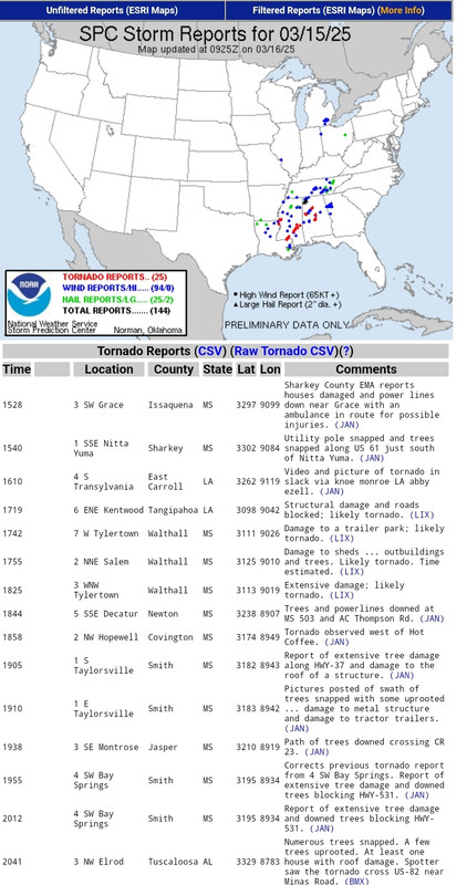
• Storm Reports
• AccuWeather
• SevereStudios met live-stormchase map
• National Center for Atmospheric Research
• Current Cape & Lift USA
• Weatheronline Expert maps
• Chasing-Live.net
Weather Channel Live Zend uit als het echt *nodig* is
• Weather Channel Live
Tv-Stations USA by state
• Newslink TV-stations by state
News channels Alabama:
• CBS42
• Fox Alabama Live
• ABC3340
• WBRC
News channels Arkansas:
• KATV
• Fox16
News channels Indiana
• channel 14
News channels Kansas:
• KAKE
• KSN
• Kansas Weather Channel LiveStream
News channels Mississippi
• MS NewsNow
• WCBI
News channels Nebraska
• KETV
• NBC Nebraska
News channels Texas:
• TXCN
• KXXV
• KLTV
• TexasStormChasers
News channels Oklahoma:
• News9
• KFOR
• Oklahoma Weather Tracker
News channel Louisiana/Kentucky
• Wave 3 News
News channel North Carolina
• 9 WNCT
Tornadochasers
• Tornadovideos.net
• Tornado titans
• Kansas Twisters
• Tornadocentral
• Texas Storm Chasers
• Storm Trackers
Mayflower, AK, EF5 tornado april 2014
SPOILEROm spoilers te kunnen lezen moet je zijn ingelogd. Je moet je daarvoor eerst gratis Registreren. Ook kun je spoilers niet lezen als je een ban hebt.El Reno, OK, EF5 tornado 31 mei 2013 - R.I.P. Team TwistexSPOILEROm spoilers te kunnen lezen moet je zijn ingelogd. Je moet je daarvoor eerst gratis Registreren. Ook kun je spoilers niet lezen als je een ban hebt.Moore, OK, EF5 tornado 20 mei 2013SPOILEROm spoilers te kunnen lezen moet je zijn ingelogd. Je moet je daarvoor eerst gratis Registreren. Ook kun je spoilers niet lezen als je een ban hebt.Joplin EF5 Tornado 22 mei 2011SPOILEROm spoilers te kunnen lezen moet je zijn ingelogd. Je moet je daarvoor eerst gratis Registreren. Ook kun je spoilers niet lezen als je een ban hebt.Tornado Outbreak 27 April 2011SPOILEROm spoilers te kunnen lezen moet je zijn ingelogd. Je moet je daarvoor eerst gratis Registreren. Ook kun je spoilers niet lezen als je een ban hebt.Tuscaloosa EF4 Tornado 27 April 2011SPOILEROm spoilers te kunnen lezen moet je zijn ingelogd. Je moet je daarvoor eerst gratis Registreren. Ook kun je spoilers niet lezen als je een ban hebt.hagelstorm Oklahoma City 16 mei 2010SPOILEROm spoilers te kunnen lezen moet je zijn ingelogd. Je moet je daarvoor eerst gratis Registreren. Ook kun je spoilers niet lezen als je een ban hebt.Yazoo City EF4 24 april 2010SPOILEROm spoilers te kunnen lezen moet je zijn ingelogd. Je moet je daarvoor eerst gratis Registreren. Ook kun je spoilers niet lezen als je een ban hebt. Parkersburg EF5 Tornado 25 mei 2008Greensburg EF5 4 mei 2007SPOILEROm spoilers te kunnen lezen moet je zijn ingelogd. Je moet je daarvoor eerst gratis Registreren. Ook kun je spoilers niet lezen als je een ban hebt.SPOILEROm spoilers te kunnen lezen moet je zijn ingelogd. Je moet je daarvoor eerst gratis Registreren. Ook kun je spoilers niet lezen als je een ban hebt.Bekijk deze YouTube-video
Nieuwsberichten, foto's, filmpjes over tornado's, onweer, overstromingen etc etc kun je hier in dit topic kwijt.
Vorige delen
http://forum.fok.nl/topicchain/853
[ Bericht 0% gewijzigd door Frutsel op 17-04-2025 20:25:26 ]Never Stop Exploring!
Life begins at the end of your comfort zone!
Follow me on Twitter: https://twitter.com/EdwinKr83 Instagram: https://www.instagram.com/edwinkr83/ Never Stop Exploring!
Life begins at the end of your comfort zone!
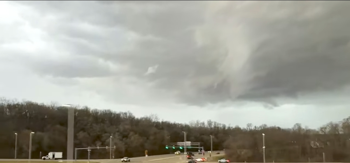
Follow me on Twitter: https://twitter.com/EdwinKr83 Instagram: https://www.instagram.com/edwinkr83/Behoorlijk wat warnings al geweest. Kon 1 tornado spotten op een stream.
Vandaag (vanavond) historische uitbraak. Gaat er slecht uitzien voor de staten Alabama en Georgia.En Mississippi.quote:Op zaterdag 15 maart 2025 06:49 schreef Drass het volgende:
Behoorlijk wat warnings al geweest. Kon 1 tornado spotten op een stream.
Vandaag (vanavond) historische uitbraak. Gaat er slecht uitzien voor de staten Alabama en Georgia.
Heb meerdere gezien op op X, maar je kan ze steeds minder vaak hier ladenNever Stop Exploring!
Life begins at the end of your comfort zone!
Follow me on Twitter: https://twitter.com/EdwinKr83 Instagram: https://www.instagram.com/edwinkr83/Nog volop bezig bij Ryan Hall.
Zie dat Mayfield weer geraakt kan worden. Dat plaatsje is paar jaar geleden al compleet verwoest qua centrum.")
heywoodu

Van bijna dood tot olympiër:Bij toeval kwam ik deze tegen, waar uitgerekend Mayfield genoemd wordt als waar het voor Hall zo'n beetje echt begon.quote:
Nog volop bezig bij Ryan Hall.
Zie dat Mayfield weer geraakt kan worden. Dat plaatsje is paar jaar geleden al compleet verwoest qua centrum.
https://people.com/real-l(...)ld-exclusive-8704217Van bijna dood op weg naar de Olympische Spelen, tot olympiër in 2026? Elk beetje hulp wordt bijzonder gewaardeerd!
https://www.gofundme.com/(...)he-spelen-na-ongevalDroom baan trouwens. Zou zo met hem willen ruilen.quote:
[..]
Bij toeval kwam ik deze tegen, waar uitgerekend Mayfield genoemd wordt als waar het voor Hall zo'n beetje echt begon.
https://people.com/real-l(...)ld-exclusive-8704217Oh Jezus, dit zou het voorgerecht moeten zijn voor vanavond, maar het was nu al knotsgek. Vanavond wordt echt behoorlijk 100.000 katjes
Fuck the EBU!Dus het kan al gaan spoken vanaf het eind van de middag Nederlandse tijd.quote:The most dangerous tornado threat should begin across eastern Louisiana and Mississippi during the late morning to afternoon, spread across Alabama late day into the evening, and reach western parts of the Florida Panhandle and Georgia Saturday night.
[ Bericht 54% gewijzigd door Nattekat op 15-03-2025 10:40:19 ]100.000 katjes
Fuck the EBU!Boven Birmingham (Alabama), wat zo'n beetje midden in de high risk area ligt, zit nu nog een hele pluk met buien net ten noorden daarvan. Dat is wel het laatste. Denk dat het dan nog wel even duurt voor het weer op gang gaat komen. Tijdverschil is 6 uur, dus wel echt eind middag begin avond Nederlandse tijd voor het ten westen van de high risk area zou moeten beginnen. Gok ikquote:
[ afbeelding ]
[ afbeelding ]
[..]
Dus het kan al gaan spoken vanaf het eind van de middag Nederlandse tijd.Never Stop Exploring!
Life begins at the end of your comfort zone!
Follow me on Twitter: https://twitter.com/EdwinKr83 Instagram: https://www.instagram.com/edwinkr83/Ik dacht dat ik Ryan hoorde zeggen, rond 4u lokale tijd is hij weer terug inderdaad.quote:
[..]
Boven Birmingham (Alabama), wat zo'n beetje midden in de high risk area ligt, zit nu nog een hele pluk met buien net ten noorden daarvan. Dat is wel het laatste. Denk dat het dan nog wel even duurt voor het weer op gang gaat komen. Tijdverschil is 6 uur, dus wel echt eind middag begin avond Nederlandse tijd voor het ten westen van de high risk area zou moeten beginnen. Gok ikDan is het hier dus 22 uur. Meest intense buien zullen daar wel vanaf een uur of 15 lokale tijd op gang gaan komen. Tussen 21 en 22 uur hier zal die wel weer live gaan.quote:
[..]
Ik dacht dat ik Ryan hoorde zeggen, rond 4u lokale tijd is hij weer terug inderdaad.Never Stop Exploring!
Life begins at the end of your comfort zone!
Follow me on Twitter: https://twitter.com/EdwinKr83 Instagram: https://www.instagram.com/edwinkr83/Hoor wat berichten over nu al flink wat gewonden en doden. Paar dorpen die vol geraakt worden door wedge tornado's. Allemaal niet best en we zijn pas in de eerste uren.Dezelfde Taylorsville die nu een PDS warning heeft gekregen voor een andere tornado?quote:100.000 katjes
Fuck the EBU!quote:
[..]
Dezelfde Taylorsville die nu een PDS warning heeft gekregen voor een andere tornado?
 Zeker 17 doden in VS door serie tornado's
Bij een reeks tornado's in de Amerikaanse staten Arkansas en Missouri zijn ten minste 17 mensen om het leven gekomen. Volgens lokale media zijn er tientallen gewonden. De schade door het natuurgeweld is op sommige plekken enorm.
De meeste slachtoffers vielen in het zuidoosten van Missouri. In die staat werden gisteravond (Amerikaanse tijd) meer dan twintig tornado's geregistreerd, waaronder een ten westen van Saint Louis, de grootste stad in Missouri.
Volgens de lokale autoriteiten in Missouri zijn zeker 500 huizen, een kerk en supermarkt door de tornado's verwoest.
In de aangrenzende staat Arkansas zijn voorlopig drie doden gemeld. Ook zijn volgens de autoriteiten 29 mensen gewond geraakt.
De nationale weerdienst waarschuwt voor nieuwe tornado's in de staten Alabama en Mississippi, die ten oosten van Arkansas liggen.
https://nos.nl/artikel/25(...)door-serie-tornado-sv20 doden..
The threat of tornadoes in parts of the U.S. proved deadly as whipping winds moved east into the Mississippi Valley and Deep South on Saturday, causing at least 20 fatalities in four states, injuries and widespread damage.
Mississippi Gov. Tate Reeves said on social media Saturday that tornadoes had been reported in six counties overnight. He said three hospitalizations have been reported and that "this number is expected to increase." More severe weather is expected in the state today, he said.vInmiddels schijnt dat al op 32 te liggenquote:Op zaterdag 15 maart 2025 22:41 schreef 12Beaufort het volgende:
20 doden..
The threat of tornadoes in parts of the U.S. proved deadly as whipping winds moved east into the Mississippi Valley and Deep South on Saturday, causing at least 20 fatalities in four states, injuries and widespread damage.
Mississippi Gov. Tate Reeves said on social media Saturday that tornadoes had been reported in six counties overnight. He said three hospitalizations have been reported and that "this number is expected to increase." More severe weather is expected in the state today, he said.Never Stop Exploring!
Life begins at the end of your comfort zone!
Follow me on Twitter: https://twitter.com/EdwinKr83 Instagram: https://www.instagram.com/edwinkr83/Wat 'n beelden, ook die post hiervoor. Die boomsprietjesquote:
https://youtube.com/shorts/ciVkpkvt_gA?si=aflHJnmAWZOWLWp1
Cave City in Arkansas Violent tornadoes ripped through parts of the U.S., wiping out schools and toppling semitractor-trailers, part of a monster storm that has killed at least 36 people across six states.
The deaths came as a massive storm system moving across the country unleashed winds that triggered deadly dust storms and fanned more than 100 wildfires. Forecasters assigned an unusual "high risk" designation to the system, which was also blamed for icy winter weather in northern parts of the country and severe thunderstorms, including on the West Coast, on Sunday.
In all, extreme weather conditions were forecast to affect an area home to more than 100 million people. Winds gusting up to 80 mph were predicted from the Canadian border to Texas, threatening blizzard conditions in colder northern areas and wildfire risk in warmer, drier places to the south.
Heavy thunderstorms in the forecast for Ponte Vedra Beach, Florida, prompted schedule changes for the 2025 Players Championship, CBS Sports reported. The tournament moved up tee times Sunday and grouped golfers together to ensure the last 18 holes would be completed before the evening.
https://news.google.com/r(...)S&gl=US&ceid=US%3AenvJe moet ook wel echt een totaalidioot zijn als je deze beelden kan maken.quote:100.000 katjes
Fuck the EBU!Die zijn er gelukkig genoeg, dus ik speur twitter wel even af :pquote:
[..]
Je moet ook wel echt een totaalidioot zijn als je deze beelden kan maken.quote:Al minstens veertig doden door stormen en tornado's in Verenigde Staten
Het aantal doden door de zware stormen die sinds vrijdag door het midden en zuiden van de Verenigde Staten trekken, is opgelopen tot minstens veertig. De stormen gaan gepaard met tornado's en bosbranden.
De staat Missouri is met zeker twaalf doden het zwaarst getroffen, melden CNN en BBC News. Gouverneur Mike Kehoe spreekt van "verbijsterende verwoesting". Hij meldt dat honderden huizen, scholen en bedrijven verloren zijn gegaan of zwaar zijn beschadigd.
In Kansas kwamen ten minste acht mensen om het leven nadat een zandstorm een kettingbotsing met 55 voertuigen had veroorzaakt. Texas werd getroffen door een soortgelijke storm. Daarbij botsten 38 auto's op elkaar en kwamen minstens vier mensen om het leven.
In Oklahoma woedden bijna 150 bosbranden, aangewakkerd door windstoten tot 133 kilometer per uur. Hierbij zijn inmiddels vier doden gemeld.
Ook Mississippi werd zwaar getroffen, met zes dodelijke slachtoffers door tornado's. In Arkansas kwamen drie mensen om en raakten 29 anderen gewond. Alabama telde nog eens drie doden, onder wie een 82-jarige vrouw.
Noodtoestand uitgeroepen in Arkansas, Georgia en Oklahoma
In Arkansas, Georgia en Oklahoma is de noodtoestand uitgeroepen. "De Nationale Garde is ingezet in Arkansas en mijn regering staat klaar om de staats- en lokale functionarissen te helpen, terwijl ze hun gemeenschappen helpen te herstellen van de schade", schrijft president Donald Trump op zijn eigen platform Truth Social.
Het stormvoorspellingscentrum van de nationale weerdienst meldt dat de stormen richting de oostkust van de VS trekken. Tegen maandagavond en dinsdag zou het aan de hele oostkust opgeklaard moeten zijn.Voor diegenen die nog weten wat de term *Joplin* in dit topic betekent
Nu op netflix
https://www.moviemeter.nl(...)oed-op-netflix-17075
Bekijk deze YouTube-videoEcht wel 1 van de meest extreme tornado's die er zijn geweest. Omvang, schade en leed. 1.6 km breed met windsnelheden 300/320 km/h. dat is echt bizar.quote:Op zaterdag 22 maart 2025 10:06 schreef Frutsel het volgende:
Voor diegenen die nog weten wat de term *Joplin* in dit topic betekent
Nu op netflix
https://www.moviemeter.nl(...)oed-op-netflix-17075
Bekijk deze YouTube-video
Ik ga dit nog wel kijkenNever Stop Exploring!
Life begins at the end of your comfort zone!
Follow me on Twitter: https://twitter.com/EdwinKr83 Instagram: https://www.instagram.com/edwinkr83/Doet mij ook weer terugdenken aan de El Reno tornado met daarbij een aantal stormjagers van Discovery die overleden.
Deze en die van Joplin via Fok kunnen volgen. Behoorlijk heftig.Ik zag hem gisteren voorbij komen.quote:
Voor diegenen die nog weten wat de term *Joplin* in dit topic betekent
Nu op netflix
https://www.moviemeter.nl(...)oed-op-netflix-17075
Bekijk deze YouTube-video
Ga ik zeker eerdaags kijken...
Een paar jaar daar voor had je die van Greensburg. Die vond ik net zo extreem...v Ik heb hem woensdag gelijk gekeken maar vond het wel jammer dat er best diep in gegaan wordt op de personen die vertellen. Ik wil gewoon vooral de spannende tornadobeelden zien en dat vond ik in verhouding te weinig. Desalniettemin altijd goed als er een natuurrampenserie/docu/film bij komt, zo vaak maken ze die niet!quote:
Voor diegenen die nog weten wat de term *Joplin* in dit topic betekent
Nu op netflix
https://www.moviemeter.nl(...)oed-op-netflix-17075
Bekijk deze YouTube-videoEr zijn tekenen dat komend weekend een flinke uitbraak kan opleveren. Ditmaal niet de mazzel dat alle energie 2 dagen eerder door een kleiner voorgerecht wordt weggenomen.100.000 katjes
Fuck the EBU!The primary severe risk appears likely to evolve Sunday/Day 6, from
Missouri/Arkansas/northern Louisiana, spreading eastward through the
day, and eventually approaching the west slopes of the Appalachians.
As the western U.S. upper trough emerges into the Plains,
supporting deepening of surface low pressure, a moist warm sector
will destabilize through the day, likely yielding storm development
initially west of the Mississippi Valley, and then spreading
eastward through the evening. The favorable thermodynamic
environment will combine with strong/veering flow through the middle
troposphere, suggesting of severe storms including supercells, and
attendant, all-hazards severe potential.
Vooralsnog geen grote zorgen, maar borrelt wel wat.Joekel van een gebied inmiddels opgewaardeerdquote:...SUMMARY...
A widespread/substantial severe-weather episode is forecast across
an area centered on the Ohio/Mid and Lower Mississippi/Lower
Missouri/Tennessee River Valleys. Very large hail, damaging winds,
and strong tornadoes are expected.
...Synopsis...
An evolving/slowly amplifying mid-level trough is forecast to shift
slowly across the central U.S. Sunday. As this occurs, a deepening
surface low will shift northeastward across the Upper Great Lakes
region. A trailing cold front will sweep southeastward across the
central U.S. as the low deepens/advances, and should extend from the
Lower Great Lakes to the central Gulf Coast states by Monday
morning.
...Lower Great Lakes to the Lower Mississippi and Tennessee
Valleys...
A broad/moist but initially capped airmass is forecast to expand
across much of the eastern half of the U.S. Sunday, ahead of the
advancing cold front. Daytime heating, and continued northward flux
of low-level moisture will result in a moderate destabilization.
Scattered storms may be ongoing across portions of Missouri
northeastward to the Wisconsin area at the start of the period, and
possibly in a more isolated manner southwestward into Texas. Local
severe risk may accompany this early-day convection. The
aforementioned destabilization that is expected should support
renewed storm development near the advancing cold front -- initially
from Illinois southwestward to East Texas, and then spreading
eastward/expanding in coverage with time.
Along with the favorable thermodynamic environment within which the
storms will be evolving, highly favorable shear will also exist,
with low-level southerly/southwesterly flow veering and increasing
substantially with height yielding curved -- and then elongated --
hodographs. Supercells are expected within this environment, and
very large hail is expected given the cold air/steep lapse rates
through the mid troposphere. Along with the hail risk, damaging
wind gusts are expected -- particularly where upscale growth into
bands occurs. Additionally, this setup appears very favorable for
tornadoes, a few of which may be strong/potentially long-lived.
Risk will spread eastward with time into the evening/overnight.
Some diminishing of the risk should occur late into the upper Ohio
Valley, but vigorous storms and all-hazards risk will likely
continue through the end of the period across the Tennessee
Valley/Gulf Coast states.Vooralsnog alleen absoluut pleurisweer, tot aan PDS thunderstorm warnings aan toe100.000 katjes
Fuck the EBU!Ook zeer veel regen verwacht in een groot gebied
Wir werden vermutlich einiges bezüglich Überschwemmungen aus den USA hören bis zum Wochenende. Der Streifen mit 100 bis lokal > 300 l/m² hat eine SW - NO Ausdehnung von über 1500 Kilometer. Alle Modelle zum Vergleich
https://x.com/Kachelmannwettr/status/1907153623215128990Never Stop Exploring!
Life begins at the end of your comfort zone!
Follow me on Twitter: https://twitter.com/EdwinKr83 Instagram: https://www.instagram.com/edwinkr83/High risk idd met name voor regen.quote:
Ook zeer veel regen verwacht in een groot gebied
Wir werden vermutlich einiges bezüglich Überschwemmungen aus den USA hören bis zum Wochenende. Der Streifen mit 100 bis lokal > 300 l/m² hat eine SW - NO Ausdehnung von über 1500 Kilometer. Alle Modelle zum Vergleich
https://x.com/Kachelmannwettr/status/1907153623215128990
Is dit ook alleen voor neerslag of nu ook voor tornado's?quote:
[ afbeelding ]
Nog iets uitgebreid vanochtend.edit: tornado's dus ookquote:...SUMMARY...
A tornado outbreak is expected today and tonight from parts of the
mid Mississippi and lower Ohio Valleys westward into the eastern
Ozarks. Numerous tornadoes, along with multiple long-track EF3+
tornadoes appear likely. In addition, tornadoes, severe wind gusts,
and large hail will be possible across a broad area from north Texas
northeastward to the southern Great Lakes.
...Mid Mississippi and Lower Ohio Valleys/Eastern Ozarks...
A potent mid-level trough will move northeastward across the central
U.S. today, as a mid-level jet strengthens to over 120 knots, and
ejects rapidly northeastward into the Upper Midwest. At the surface,
a low will move into the upper Mississippi Valley, as a cold front
advances eastward through the central states. Ahead of the front, a
moist airmass will advect northward into the Ozarks and lower to mid
Mississippi Valley, with surface dewpoints increasing into the mid
to upper 60s F. While storms will likely be ongoing near the front
during the day, the airmass further to the east is forecast to
remain undisturbed and will significantly destabilize during the
day. By early to mid afternoon, MLCAPE is forecast to increase into
the 2500 to 3500 J/kg range across much of the moist airmass. The
500 mb jet is forecast to eject northeastward at nearly 55 knots
into the upper Mississippi Valley. Large-scale ascent associated
with the right entrance region of the jet will overspread the moist
sector, becoming favorable for vigorous convective development.
Model forecasts are in relatively good agreement, that scattered
discrete convective initiation will take place well to the east of
the front near the instability axis during the mid to late
afternoon. Forecast soundings across the mid Mississippi Valley from
21Z to 00Z increase 0-3 km storm-relatively helicity to around 400
m2/s2, and have strong deep-layer shear near 60 knots. This will be
favorable for supercells and tornadoes. The ECMWF and NAM are in
good agreement, developing a 60 to 70 knot low-level jet max
centered over far western Tennessee at 00Z. As supercells move
eastward into the low-level jet, very strong low-level shear will be
favorable for numerous tornadoes. The most intense tornadic
supercells will be capable of producing long-track EF3+ tornadoes.
Multiple EF3+ tornadoes are expected in the mid Mississippi Valley.
The duration of the tornado threat should persist from afternoon
into the evening. A potential for supercells and tornadoes will
extend northward into the lower Ohio Valley and southwestward into
the southern Ozarks. In those two locations, the more intense
discrete supercells could produce strong tornadoes.
In addition to the tornado threat, supercells associated with large
hail and severe wind gusts are expected to form in the mid to late
afternoon across a large area from the Ark-La-Tex northeastward to
the southern Great Lakes. Large hail will also be possible with
supercells that develop along and near the front, further west into
the Ozarks. The more intense supercells should have potential to
produce hailstones greater than 2 inches in diameter. During the mid
to late evening and overnight period, several organized line
segments are expected to organize and move eastward into the
Tennessee Valley, lower Ohio Valley and southern Great Lakes. Gusts
above 70 mph will be possible with the more intense bowing segments.
The severe threat is expected to continue into the overnight period.
...North Texas...
A mid-level trough will move northeastward across the central Plains
this morning. At the surface, as a cold front will advance eastward
through the southern Plains. Ahead of the front, a moist and
unstable airmass will be in place over much of the eastern half of
Texas. In spite of weak forcing, isolated thunderstorms may initiate
along or ahead of the front as surface temperatures warm this
morning. Forecast soundings ahead of the front in north Texas have
0-6 km shear around 50 knots with 700-500 mb lapse rates near 7.5
C/km. This environment will likely support a large hail threat with
any supercells that can develop. Hailstones greater than 2 inches in
diameter and severe wind gusts will be possible within the more
vigorous supercell downdrafts. The severe threat is expected to
gradually end during the day across parts of northwest and
north-central Texas as the front moves eastward. However, isolated
supercells with large hail could redevelop during the evening and
overnight, as warm advection again brings low-level moisture
northward into the Red River Valley.Blijft ook donderdag, vrijdag en zaterdag onrustig waarbij het grootste gevaar op woensdag en zaterdag ligtwel vaak raak de laatste tijd. 2e high risk alNever Stop Exploring!
Life begins at the end of your comfort zone!
Follow me on Twitter: https://twitter.com/EdwinKr83 Instagram: https://www.instagram.com/edwinkr83/
Van bijna dood tot olympiër:Van bijna dood op weg naar de Olympische Spelen, tot olympiër in 2026? Elk beetje hulp wordt bijzonder gewaardeerd!
https://www.gofundme.com/(...)he-spelen-na-ongeval
Van bijna dood tot olympiër:Een Y'All Watch Van bijna dood op weg naar de Olympische Spelen, tot olympiër in 2026? Elk beetje hulp wordt bijzonder gewaardeerd!
https://www.gofundme.com/(...)he-spelen-na-ongevalSelmer TN is al geraakt door een tornado maar die bovenstaande links van Hornsby gaat er nog een keer overheen als ze pech hebbenquote:
Edit: Minimaal één van die foto's is nep, want daglicht. Eerste comment onder die Tweet haalt dat ook al aan. Triest.100.000 katjes
Fuck the EBU!De warnings blijven maar komen ook, het houdt niet op. Ze zullen geen lekkere nachtrust hebben daar100.000 katjes
Fuck the EBU!Plons
Das sind die Regenmengen bis einschließlich Samstag in Arkansas und angrenzend. Das Gebiet hier mit 150 bis 300 l/m² ist etwa 700 km lang und bis um 300 km breit. Es werden große Überflutungen erwartet. Andere Modelle über die blauen Buttons oben. /FR
https://x.com/Kachelmannw(...)fcPWpYDHQB2x_AQ&s=19Never Stop Exploring!
Life begins at the end of your comfort zone!
Follow me on Twitter: https://twitter.com/EdwinKr83 Instagram: https://www.instagram.com/edwinkr83/
Van bijna dood tot olympiër: Ja, sowieso.quote:Van bijna dood op weg naar de Olympische Spelen, tot olympiër in 2026? Elk beetje hulp wordt bijzonder gewaardeerd!
https://www.gofundme.com/(...)he-spelen-na-ongevalElk jaar een paar maanden lang mogelijk. Onzekerheidquote:
Je zou maar in Arkanas wonen. Drie van dit soort avonden op rij.Never Stop Exploring!
Life begins at the end of your comfort zone!
Follow me on Twitter: https://twitter.com/EdwinKr83 Instagram: https://www.instagram.com/edwinkr83/Zeker zeven doden door noodweer en tornado's in VS
Bij zware stormen die door het midden van de Verenigde Staten razen zijn zeker zeven mensen om het leven gekomen.
Volgens ABC News zijn de afgelopen 24 uur zeker 24 tornado's ontstaan. Behalve voor tornado's wordt ook gewaarschuwd voor overstromingen.
In drie verschillende staten worden doden gemeld. In Tennessee vielen zeker vijf doden en ook in Missouri en Indiana vielen doden. Ook raakten minstens dertien mensen gewond toen tornado's en zware onweersbuien door de getroffen gebieden trokken. De schade aan huizen, wegen en elektriciteitsvoorzieningen is in sommige gebieden groot.
Noodtoestand
De gouverneurs van Tennessee en Kentucky hebben de noodtoestand afgekondigd. En in onder meer Texas gelden tornadowaarschuwingen. Het slechte weer in het gebied begon woensdag en duurt waarschijnlijk tot en met zaterdag.
Het is de tweede keer in korte tijd dat het gebied wordt getroffen door noodweer. In maart kwamen bij stormen in het zuiden en het Middenwesten ruim veertig mensen om het leven.
https://nos.nl/artikel/25(...)r-en-tornado-s-in-vsvDodental opgelopen naar 23... zwaarste tornado staat momenteel nog altijd op EF3+
Aantal tornado's wordt nog onderzocht, waaronder die bij Selmer, mogelijk gaan die nog opgewaardeerd worden.
https://en.wikipedia.org/(...)il_2%E2%80%937,_2025Bekijk deze YouTube-video
Never forget
Staat trouwens nog een stuk over in het eerste deel uit 2007 van deze reeks
Zat de stream van Ryan te bekijken, machtig ding vannacht. 2 textbook supercells met tornado's daarin en de klassieke hook.Bekijk deze YouTube-videoquote:Tornadoes rip through Omaha and Essex as severe weather sweeps across Nebraska and Iowa
At least 15 tornadoes touched down in Iowa and Nebraska on April 17, 2025, as a severe weather system swept through the region. Tornadoes were confirmed in Omaha, Nebraska, and Essex, Iowa, damaging homes, toppling power lines, and causing significant disruption to local communities.
The Storm Prediction Center (SPC) received 15 tornado reports across Nebraska and Iowa as a severe weather system moved southward through the state on Thursday, April 17.
Ten tornadoes were reported in Nebraska, while 5 were reported in Iowa. While many other tornadoes have been reported in the region, they are yet to be confirmed by the National Weather Service (NWS).
A tornado touched down in Omaha at around 19:00 local time on Thursday, prompting people to take shelter as the sirens went off. Tornado sirens also went off in Bennington and Elkhorn. At Eppley Airfield, people took cover for about 15 minutes as the storm approached.
For a brief period, the NWS flagged the event as “catastrophic” as it passed through the region and moved eastwards.
Authorities in Douglas and Washington Counties reached the scene to assess the impact and urged citizens to avoid the area between 72nd Street and 78th Street, from Omaha Trace to Dutch Hall Road.
“There are multiple downed power lines, damage to homes, and scattered debris,” the Douglas County Sheriff’s Office said.Met zoals gisteren weer wat kansen op tornado's. Gisternacht eentje gespot, maar was daar ook al donker. Dus niet al te mooi.Het is toch bizar dat deze medewerkers gewoon bleven werken ondanks er een zware onweersbui aan zat te komen.quote:
Echter denk ik eerder dat het hier om de gustfront gaat dan om een tornado, die hadden dit niet overleefd of waren zwaar gewond, ook al was het op 100meter afstand dat de tornado langs trok. Natuurlijk hangt het wel vanaf hoe sterk die was.
Wat me wel opvalt is dat ze geluk hebben dat de wind vanaf het schuine dak komt, dus de meeste wind schoot over hun heen.Ja dan stelt het niks voor natuurlijk, tot je em zelf over je heen krijgtquote:
[..]
Dan ziet zo'n wedge er op eens heel lullig uit.Ja gaat lekker daar zeg, een kijken of we beelden van kunnen oppakken vandaagquote:
Moderate day 3 risk. Dat moet haast wel roze gaan kleuren... Doe mee met het voorspellen van het weer!
Weekvoorspelling | Week 37 (Inschrijven tot 8-9, 11:59)
Maandvoorspelling | September (Gesloten)
Jaarvoorspelling 2024! / 2025!Die is inderdaad mooi.quote:
En dan buiten de supercel een wolkenloze lucht waardoor de hele structuur goed te zien is.Ja vannacht 1.5u kunnen volgen. Historisch grote wedge van meer dan een uur op de grond. Daarna werden het nog iets kleinere. Prachtige losse supercells.quote:
Gaat er vanavond ook zo uit zien.Schijnt een hele flinke huis te houden in St. Louis momenteel. Dus eh.quote:
Tornado kans is vrij klein. Gaat vooral om zware windstoten.
Het zijn dit jaar echt de dagen dat je het niet verwacht die het meest leveren.100.000 katjes
Fuck the EBU!
Sommerset, Kentucky
Die hebben een behoorlijk pittige over zich heen gekregen100.000 katjes
Fuck the EBU!Die kregen 3 supercells over zich heen in een paar uur.quote:
[ afbeelding ]
Sommerset, Kentucky
Die hebben een behoorlijk pittige over zich heen gekregen
En het schuift langzaam op richting tornado alley.
Echt een belachelijk actief jaar dit trouwens.100.000 katjes
Fuck the EBU!
Je hoeft geen expert te zijn om het monster op deze kaart te herkennen. Greensburg heeft echt heel veel geluk gehad 100.000 katjes
Fuck the EBU!
Daarin tegen is Plevna in Kansas geraakt met wat lijkt op 1 van de zwaarste tornado's van dit jaar.
Enorme wedge die gelukkig daarna uit elkaar viel voordat een grote stad werd bereikt.Ik denk dat dit dezelfde storm is.quote:
[ x ]
Daarin tegen is Plevna in Kansas geraakt met wat lijkt op 1 van de zwaarste tornado's van dit jaar.
Enorme wedge die gelukkig daarna uit elkaar viel voordat een grote stad werd bereikt.100.000 katjes
Fuck the EBU!Even duimen dat het in het oostelijke deel van dat gebied gebeurt. Moore is al heel lang buiten schot gebleven en dat mag wel zo blijven.quote:
Weer een moderate outbreak vandaag. Groter gebied, vooral Oklahoma.100.000 katjes
Fuck the EBU!Eens daar wonen ook weinig mensen ipv bij Oklahoma City.quote:
[..]
Even duimen dat het in het oostelijke deel van dat gebied gebeurt. Moore is al heel lang buiten schot gebleven en dat mag wel zo blijven.Inmiddels geupgrade naar EF4.quote:
[ x ]
Nog van eergisteren. Goed het pad te zien.100.000 katjes
Fuck the EBU!Brad Arnold en Reed Timmer rijden achter elkaar. Dan weet je dat er wat staat te gebeuren daar.100.000 katjes
Fuck the EBU!Bekijk deze YouTube-videoquote:Giant hail and tornadoes hit Afton area, Texas as storms sweep through southern U.S.
Giant hail measuring up to 15 cm (6 inches) struck Afton, Texas, on Sunday, May 25, 2025, as storms swept across the southern U.S. during Memorial Day weekend. The storms were accompanied by multiple tornadoes, with at least five reported in Texas, including one near Afton.
A quasi-stationary storm system brought large hail to the Southeast and Mid-Atlantic on Sunday, May 25, with reports of hailstones exceeding 10 cm (4 inches) in diameter in parts of Texas.
The Storm Prediction Center received three of the largest hail reports from Afton, with measurements of 15 cm (6 inches), 13 cm (5 inches), and 11.5 cm (4.5 inches). Additional reports on social media indicated hailstones in the Afton area measuring between 14 and 15 cm (5.5 to 6 inches).
At least six tornadoes were reported on Sunday, including five in Texas and one in New Mexico. One tornado occurred near Afton.
A green-hued supercell was observed near Guthrie, producing large hail up to 13 cm (5 inches) in diameter and giving the sky a greenish-blue hue.
The storms were part of a slow-moving system extending from the Southeast to the Central Rockies, bringing severe weather to parts of the southern United States, including Texas, Missouri, and Oklahoma, on May 25.
Storm damage was reported across Oklahoma on Saturday, May 24, as storms downed trees and power lines, damaged buildings, and left nearly 60 000 people without power.Het is vandaag 12 jaar geleden dat team Twistex om is gekomen bij de El Reno EF3 tornado100.000 katjes
Fuck the EBU!quote:Severe storm, suspected tornado cause damage in Cattaraugus County, New York
A severe storm, potentially accompanied by a tornado, struck Cattaraugus County, New York, on June 9, 2025, causing significant damage to homes, infrastructure, and trees, and leaving 400 customers without power.
e National Weather Service issued a Tornado Warning for the county at 17:36 local time (LT), urging residents in Great Valley, Franklinville, Humphrey, and Ellicottville to seek shelter.
The storm moved northeast at 25 km/h (15 mph), causing significant structural damage to homes, leveling farms, and uprooting trees. It left a clear path of destruction visible through wooded areas and about 400 customers without power.
In Great Valley, a FedEx employee was trapped in a van that was thrown into a ravine by the storm but was rescued unharmed.
NWS Buffalo is analyzing damage patterns to determine the cause of damage.
Forum Opties Forumhop: Hop naar: