WKN Weer, Klimaat en Natuurrampen
Lees alles over het onstuimige weer op onze planeet, volg orkanen en tornado's, zie hoe vulkanen uitbarsten en hoe Moeder Aarde beeft bij een aardbeving. Alles over de verwoestende kracht van onze planeet en tal van andere natuurverschijnselen.


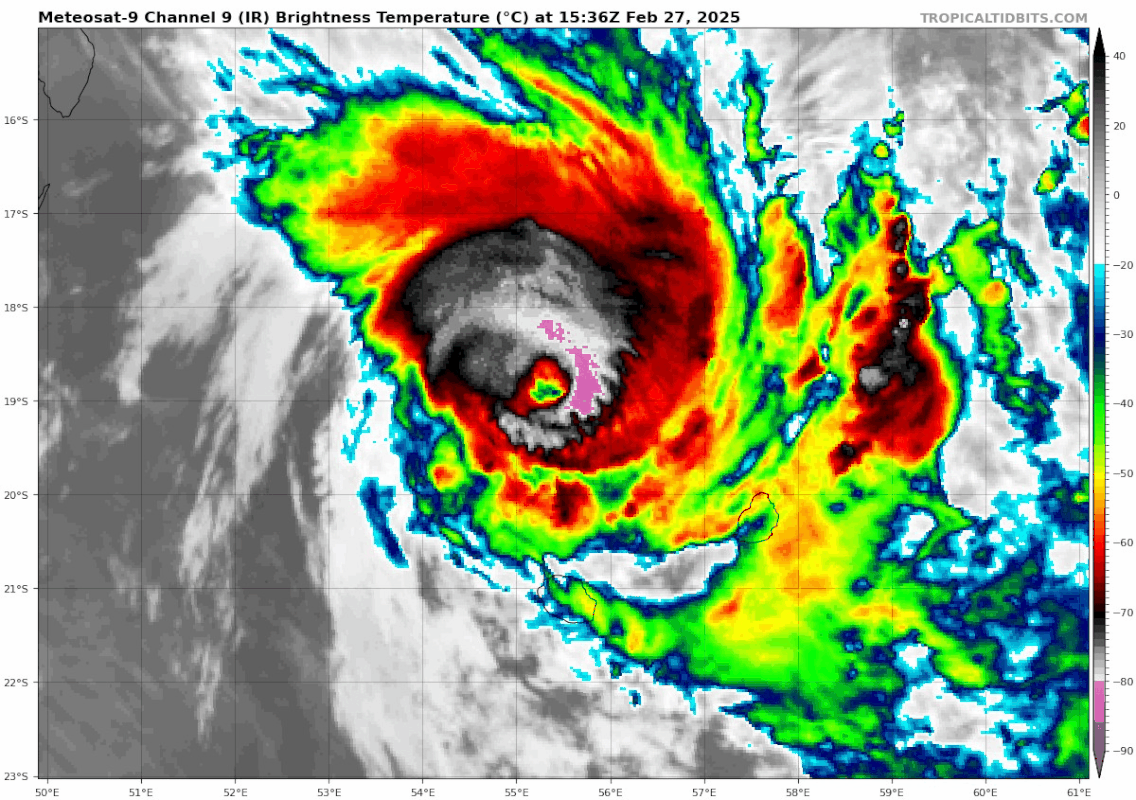
Cycloon Garance nadert Réunion
Garance raast richting het Franse eiland Réunion en zal waarschijnlijk de eerste cycloon met orkaankracht zijn die het eiland in 36 jaar tijd treft.
Réunion ligt ten oosten van Madagascar en heeft ongeveer 900.000 inwoners. Meteo France heeft een rode waarschuwing voor het eiland afgegeven vanwege hoge golven, die het eiland al hebben bereikt, en sterke winden.
Meteo France meldde dat cycloon Garance donderdagavond lokale tijd een "intense cycloon" was, met winden die overeenkomen met een categorie 3 orkaan op de Saffir-Simpson windschaal.
"Garance zal Réunion later donderdagavond tot vrijdag treffen met zeer veel regen. Lokale hoeveelheden kunnen oplopen tot meer dan 50 cm.
"Windstoten tot 240 km zijn mogelijk, wat zal leiden tot schade. Door de neerslag, en hoge golven kunnen landverschuivingen en overstromingen ontstaan.
https://www.accuweather.c(...)-hit-reunion/1749300
v
Een paarse waarschuwing voor Reunion. De orkaan ligt nu voor de kust van het eiland met een kerndruk van 954mb.

quote:La Réunion island raises highest 'purple alert' as cyclone nears
Weather service Meteo-France warned there could be a "direct impact" on La Réunion, urging the population of around 900,000 to stay indoors.
Authorities in La Réunion put the Indian Ocean island on its highest "purple alert" Friday, February 28, as a cyclone bore down threatening a "direct impact."
"Faced with a direct impact, with winds gusting to more than 200 km/h (around 125 miles per hour), the prefect will trigger the purple alert," authorities said in a press release published on X.
La Réunion and nearby Mauritius – around 225 kilometres (140 miles) to the northeast – have been on high alert since Wednesday as Cyclone Garance neared the popular tourist destinations.
Mauritius shut its main airport on Wednesday, while La Réunion did the same on Thursday.
Weather service Meteo-France warned there could be a "direct impact" on La Réunion, urging the population of around 900,000 to stay indoors.
https://www.lemonde.fr/en(...)nears_6738666_4.html
v

quote:Tropical Cyclone Garance makes historic landfall over Réunion Island
Tropical Cyclone Garance made a historic landfall over Réunion Island at approximately 10:00 local time (06:00 UTC) on February 28, 2025, bringing in record winds of over 200 km/h (125 mph) to the region. A Purple Violent Cyclone Alert is in effect for the entire island.
Tropical Cyclone Garance made landfall on the north coast of Réunion Island at approximately 10:00 local time (06:00 UTC) on February 28, 2025, bringing destructive winds and heavy rainfall.
At the time of landfall, the cyclone’s minimum central pressure was recorded at 971.5 hPa in Gillot, located about 7 km (4 miles) east of Saint-Denis. The storm is moving south-southwest at approximately 24 km/h (15 mph) and is expected to maintain this trajectory throughout Friday.
Historical records indicate that only five cyclones have previously made landfall on the island, making Garance the sixth. However, this number may vary due to inconsistencies in older meteorological records.
The cyclone produced wind gusts of 214 km/h (133 mph) at Gillot Airport, the highest recorded since Cyclone Jenny struck the island in 1962. “With modern observation methods, this is a record for the station,” Météo France meteorologists said.
Wind gusts reached 174 km/h (108 mph) at Maïdo, 169 km/h (105 mph) at Bellevue-Bras Panon, and 16 km/h (10 mph) at Plaine des Cafres. The strong winds have uprooted trees and torn roofs off buildings on the island.
A Purple Violent Cyclone Alert is in effect for the entire island. Wind gusts of up to 220 km/h (137 mph) are forecast for northern and eastern areas.
“Beware of the temporary calm associated with the eye’s passage, which may be locally felt. Heavy rainfall and very dangerous seas accompany the cyclone,” Météo France said.
Despite some improvement, severe weather is expected to persist through Friday into Saturday, March 1. Wind gusts of 80–100 km/h (50–62 mph) will continue across much of the island through early Friday night before weakening to 60–80 km/h (37–50 mph) by late Friday night.
Rough sea conditions will persist due to strong winds and a northwest swell of 1.5–2 m (5–6.5 feet) from Pointe des Aigrettes to Pointe des Cascades. Conditions are expected to improve on Saturday morning, with rainfall decreasing by the afternoon.
Strong northerly winds with gusts of 70–80 km/h (44–50 mph) will persist from Saint-Paul to Étang-Salé, from Sainte-Rose to Saint-Philippe, and in all exposed highlands and plains. Winds will be noticeably weaker in Chef-Lieu and Saint-Pierre.

3 doden...
quote:At least three people died when cyclone Garance slammed into the French overseas territory of La Reunion on Friday with wind speeds of up to 155 kph (96 mph), Prime Minister Francois Bayrou said.
The cyclone made landfall in the north of the Indian Ocean island, which lies off Madagascar, blowing away roofs and cutting power and access to drinking water for many residents. It exited the southwest of the island several hours later, Meteo France weather agency said.
Meteo France said the worst of the storm had passed. The storm alert was downgraded from the highest level, purple, to red, earlier in the day, which allowed rescue workers to leave their shelters and start to assess damage and help those affected.
A mandatory order for residents to stay indoors remained in place and authorities expected rough weather conditions until at least the end of the day.
The prefecture said earlier that 180,000 households - about 42% of the electricity utility's customers - had lost power, and nearly 10% had no access to drinking water.
Wind speeds had dropped, Meteo France said, but 80-100 kph gusts were possible overnight, with heavy rains now seen as a bigger risk. Weather conditions should improve on Saturday.
In nearby Mauritius, authorities reopened the airport after the threat from the storm eased.
https://www.reuters.com/b(...)ties-say-2025-02-28/
v
Dodentol opgelopen tot vijf na cycloon op La Réunion
De dodentol van de doortocht van cycloon Garance op het Franse eiland La Réunion is gestegen naar vijf. In de hoofdstad Saint-Denis de la Réunion werd het lichaam van een man gevonden. Dat meldt de prefectuur van het Franse overzeese departement in de Indische Oceaan.
Vrijdag raakte reeds bekend dat in de hoofdstad een vrouw meegesleurd werd door het water en dat een man om het leven kwam bij een brand ontstaan door een elektriciteitsprobleem. In de gemeente Trois Bassins liet een vrouw het leven toen ze gegrepen werd door een modderstroom. In Saint-Denis werd ook al het levenloze lichaam van een man gevonden.
De cycloon kwam vrijdag aan land op het eiland ten westen van Madagaskar. Tot zaterdagochtend gold er nog alarmfase rood. De storm ontwortelde bomen, wagens werden meegesleurd door het wassende water en wegen en elektriciteit onderbroken.
https://www.gva.be/buiten(...)eunion/46952951.html
v
|
|